Madison County, Virginia

Last updated

Madison County
Madison County Courthouse (Built 1829), Madison, Virginia.jpg
Madison County Courthouse, built 1829
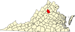
Map of Virginia highlighting Madison County.svg
Location within the U.S. state of Virginia
Virginia in United States.svg
Virginia's location within the U.S.
Coordinates: 38°25′N78°17′W / 38.41°N 78.28°W / 38.41; -78.28
CountryFlag of the United States.svg United States
StateFlag of Virginia.svg  Virginia
Founded1792
Named for Madison family
Seat Madison
Largest townMadison
Area
  Total322 sq mi (830 km2)
  Land321 sq mi (830 km2)
  Water1.2 sq mi (3 km2)  0.4%
Population
 (2020)
  Total13,837
  Density43/sq mi (17/km2)
Time zone UTC−5 (Eastern)
  Summer (DST) UTC−4 (EDT)
Congressional district 7th
Website www.madisonco.virginia.gov

Madison County is a county located in the Commonwealth of Virginia. As of the 2020 census, the population was 13,837. [1] Its county seat is Madison. [2]

Contents

History

Madison County was established in December 1792, created from Culpeper County. [3] The county is named for the Madison family that owned land along the Rapidan River. President James Madison is a descendant of that family.

Geography

Charlottesville to Merrifield.svg
Madison

According to the U.S. Census Bureau, the county has a total area of 322 square miles (830 km2), of which 321 square miles (830 km2) is land and 1.2 square miles (3.1 km2) (0.4%) is water. [4]

A significant portion of western Madison County is within Shenandoah National Park, including Hawksbill Mountain, the highest point in both the park and in Madison County, Old Rag Mountain, one of the park's most popular tourist destinations, and Rapidan Camp, the presidential retreat built by Herbert Hoover. Hoover's Camp was built between 1929 and 1932. The camp consisted of 13 buildings with the main one being "The Brown House". In 2017, only three of these houses are still standing (The Brown House, The Prime Minister Cabin, and The Creel). The camp was built where two streams merge to form the Rapidan River because fishing was Hoover's favorite pastime. Hoover even made sure that the camp was built at an elevation where mosquitos would not be a nuisance while fishing. The camp was donated to the Commonwealth of Virginia in 1932 so other presidents could use it and in December 1935 it officially became a part of Shenandoah National Park. [5]

Adjacent counties

National protected area

Major highways

Demographics

Historical population
CensusPop.Note
1800 8,322
1810 8,3810.7%
1820 8,4901.3%
1830 9,2368.8%
1840 8,107−12.2%
1850 9,33115.1%
1860 8,854−5.1%
1870 8,670−2.1%
1880 10,56221.8%
1890 10,225−3.2%
1900 10,216−0.1%
1910 10,055−1.6%
1920 9,595−4.6%
1930 8,952−6.7%
1940 8,465−5.4%
1950 8,273−2.3%
1960 8,187−1.0%
1970 8,6385.5%
1980 10,23218.5%
1990 11,94916.8%
2000 12,5204.8%
2010 13,3086.3%
2020 13,8374.0%
U.S. Decennial Census [6]
1790–1960 [7] 1900–1990 [8]
1990–2000 [9] 2010 [10] 2020 [11]

2020 census

Madison County, Virginia – Racial and ethnic composition
Note: the US Census treats Hispanic/Latino as an ethnic category. This table excludes Latinos from the racial categories and assigns them to a separate category. Hispanics/Latinos may be of any race.
Race / Ethnicity (NH = Non-Hispanic)Pop 2010 [10] Pop 2020 [11] % 2010% 2020
White alone (NH)11,39411,56385.62%83.57%
Black or African American alone (NH)1,2921,0569.71%7.63%
Native American or Alaska Native alone (NH)22140.17%0.10%
Asian alone (NH)74860.56%0.62%
Pacific Islander alone (NH)410.03%0.01%
Some Other Race alone (NH)10530.08%0.38%
Mixed Race or Multi-Racial (NH)2766232.07%4.50%
Hispanic or Latino (any race)2364411.77%3.19%
Total13,30813,837100.00%100.00%

2000 Census

As of the census [12] of 2000, there were 12,520 people, 4,739 households, and 3,521 families residing in the county. The population density was 39 people per square mile (15 people/km2). There were 5,239 housing units at an average density of 16 units per square mile (6.2 units/km2). The racial makeup of the county was 86.71% White, 11.41% Black or African American, 0.14% Native American, 0.50% Asian, 0.02% Pacific Islander, 0.29% from other races, and 0.93% from two or more races. 0.77% of the population were Hispanic or Latino of any race.

There were 4,739 households, out of which 30.90% had children under the age of 18 living with them, 61.40% were married couples living together, 8.80% had a female householder with no husband present, and 25.70% were non-families. 21.80% of all households were made up of individuals, and 9.50% had someone living alone who was 65 years of age or older. The average household size was 2.60 and the average family size was 3.03.

In the county, the population was spread out, with 24.10% under the age of 18, 6.90% from 18 to 24, 27.60% from 25 to 44, 26.40% from 45 to 64, and 15.00% who were 65 years of age or older. The median age was 40 years. For every 100 females there were 95.00 males. For every 100 females aged 18 and over, there were 94.60 males.

The median income for a household in the county was $39,856, and the median income for a family was $44,857. Males had a median income of $30,805 versus $24,384 for females. The per capita income for the county was $18,636. About 6.90% of families and 9.60% of the population were below the poverty line, including 12.70% of those under age 18 and 10.20% of those age 65 or over.

Communities

Towns

Census-designated place

Other unincorporated communities

Politics

Madison County is a Republican stronghold and has not voted for a Democratic presidential nominee since 1940.

United States presidential election results for Madison County, Virginia [13]
Year Republican Democratic Third party
No.%No.%No.%
2020 5,30065.20%2,69833.19%1311.61%
2016 4,41963.32%2,20331.57%3575.12%
2012 3,86958.50%2,63939.90%1061.60%
2008 3,75856.10%2,86242.72%791.18%
2004 3,55661.61%2,17637.70%400.69%
2000 2,94058.48%1,84436.68%2434.83%
1996 2,29650.91%1,73438.45%48010.64%
1992 2,34148.99%1,70035.57%73815.44%
1988 2,50162.12%1,42735.44%982.43%
1984 2,72367.15%1,30232.11%300.74%
1980 1,95955.64%1,35138.37%2115.99%
1976 1,71052.97%1,46645.42%521.61%
1972 1,86473.41%63925.17%361.42%
1968 1,18848.71%47819.60%77331.69%
1964 1,06055.12%86244.83%10.05%
1960 99860.38%63638.48%191.15%
1956 85056.86%53335.65%1127.49%
1952 1,01264.96%54034.66%60.39%
1948 66255.72%42836.03%988.25%
1944 81156.79%61643.14%10.07%
1940 64648.14%69251.56%40.30%
1936 66245.13%80454.81%10.07%
1932 52237.83%84961.52%90.65%
1928 77257.10%58042.90%00.00%
1924 34735.74%58960.66%353.60%
1920 43145.80%49953.03%111.17%
1916 34837.50%57261.64%80.86%
1912 21031.02%40259.38%659.60%

Education

Madison County Public Schools has around 2000 students in four schools. Madison Primary School has grades K–2 and has around 370 students. Waverly Yowell Elementary School has grades 3–5 and around 410 students. William Wetsel Middle School has grades 6–8 and around 415 students. Madison County High School has grades 9–12 and has around 665 students. All statistics based on 2007–2008 VA DOE statistics. It is also home to Woodberry Forest School, a private, all-male boarding school.

Censorship

In January 2023, the Madison County School Board banned 21 books from the high school library, including books by Stephen King, Toni Morrison, and Christian writer Anne Rice. [14]

Madison County High School

Madison County High School is the county's only High School. Grades 9–12 attend MCHS. The total number of students at MCHS was 584 for 2013–2014. [15] Madison County's nickname is the Mountaineers and have two main logos. One is an inked drawing of a Mountaineer standing on a mountain. In the background, a caravan of people and covered wagons can be seen being led by the Mountaineer. The second main logo is a "M" with a "C" offset and connected to it standing for Madison County, the name of both the county and high school. The colors are blue and white. MCHS fields athletic teams in football, basketball, soccer, volleyball, wrestling, track, cross country, golf, baseball and softball. Swimming was added as a sport in 2011. Cheerleading teams are also fielded for football and basketball games. Madison is home to the 2012 Group A, Division 1 state champions in Forensics.

MCHS offers AP courses and dual enrollment courses through Germanna Community College. MCHS has full accreditation from the Virginia Department of Education with Virginia Standards of Learning passing rates ranging from 94 percent on the history to 86 percent on the science. MCHS graduates more than 90% of its students per year.

William H. Wetsel Middle School

William H. Wetsel Middle School was opened in August 1993 under the leadership of Principal, John Anderson. Grades 6 and 7 were moved from Waverly Yowell Elementary School and Grade 8 was removed from Madison County High School to form a Grades 6-8 middle school. William Wetsel, the school's namesake, was a former agriculture teacher and superintendent in Madison County.

See also

Related Research Articles

<span class="mw-page-title-main">Frederick County, Virginia</span> County in Virginia, United States

Frederick County is located in the Commonwealth of Virginia. As of the 2020 census, the population was 91,419. Its county seat is Winchester. The county was formed in 1743 by the splitting of Orange County. It is Virginia's northernmost county. Frederick County is included in the Winchester, VA-WV Metropolitan Statistical Area, which is also included in the Washington-Baltimore-Northern Virginia, DC-MD-VA-WV-PA Combined Statistical Area.

<span class="mw-page-title-main">Greene County, Virginia</span> County in Virginia, United States

Greene County is a county in Virginia in the eastern United States. As of the 2020 census, the population was 20,552. Its county seat is Stanardsville.

<span class="mw-page-title-main">Warren County, Virginia</span> County in Virginia, United States

Warren County is a U.S. county located in the Commonwealth of Virginia. The 2020 census places Warren County within the Washington-Arlington-Alexandria, DC-VA-MD-WV Metropolitan Statistical Area with a population of 40,727. The county was established in 1836. The county seat is Front Royal.

<span class="mw-page-title-main">Spotsylvania County, Virginia</span> County in Virginia, United States

Spotsylvania County is a county in the U.S. state of Virginia. As of the July 2021 estimate, the population was 145,300. Its county seat is Spotsylvania Courthouse.

<span class="mw-page-title-main">Shenandoah County, Virginia</span> County in Virginia, United States

Shenandoah County is a county located in the Commonwealth of Virginia. As of the 2020 United States Census, the population was 44,186. Its county seat is Woodstock. It is part of the Shenandoah Valley region of Virginia.

<span class="mw-page-title-main">Rockingham County, Virginia</span> County in Virginia, United States

Rockingham County is a county located in the U.S. state of Virginia. As of the 2020 census, the population was 83,757. Its county seat is the independent city of Harrisonburg.

<span class="mw-page-title-main">Richmond County, Virginia</span> County in Virginia, United States

Richmond County is a county located on the Northern Neck in the U.S. state of Virginia. As of the 2020 census, the population sits at 8,923. Its county seat is Warsaw. The rural county should not be confused with the large city and state capital Richmond, Virginia. It was formed in 1692 when the first Rappahannock County was divided to form Richmond County and Essex County.

<span class="mw-page-title-main">Rappahannock County, Virginia</span> County in Virginia, United States

Rappahannock County is a county located in the northern Piedmont region of the Commonwealth of Virginia, US, adjacent to Shenandoah National Park. As of the 2020 Census, the population was 7,348. Its county seat is Washington. The name "Rappahannock" comes from the Algonquian word lappihanne, meaning "river of quick, rising water" or "where the tide ebbs and flows." The county is included in the Washington-Arlington-Alexandria, DC-VA-MD-WV Metropolitan Statistical Area.

<span class="mw-page-title-main">Pulaski County, Virginia</span> County in Virginia, United States

Pulaski County is a county located in the southwestern part of the U.S. state of Virginia. As of the 2020 census, the population was 33,800. Its county seat is Pulaski. Pulaski County is part of the Blacksburg–Christiansburg, VA Metropolitan Statistical Area.

<span class="mw-page-title-main">Page County, Virginia</span> County in Virginia, United States

Page County is located in the Commonwealth of Virginia. As of the 2020 census, the population was 23,709. Its county seat is Luray. Page County was formed in 1831 from Shenandoah and Rockingham counties and was named for John Page, Governor of Virginia from 1802 to 1805.

<span class="mw-page-title-main">Orange County, Virginia</span> County in Virginia, United States

Orange County is a county located in the Central Piedmont region of the Commonwealth of Virginia. At the 2020 census, the population was 36,254. Its county seat is Orange. Orange County includes Montpelier, the 2,700-acre (1,100 ha) estate of James Madison, the 4th President of the United States and often known as the "Father of the Constitution". The county will celebrate its 290th anniversary in 2024.

<span class="mw-page-title-main">Middlesex County, Virginia</span> County in Virginia, United States

Middlesex County is a county located on the Middle Peninsula in the U.S. state of Virginia. As of the 2020 census, the population was 10,625. Its county seat is Saluda.

<span class="mw-page-title-main">Culpeper County, Virginia</span> County in Virginia, United States

Culpeper County is a county located along the borderlands of the northern and central region of the Commonwealth of Virginia. As of the 2020 United States Census, the population was 52,552. Its county seat and only incorporated community is Culpeper.

<span class="mw-page-title-main">Bath County, Virginia</span> County in Virginia, United States

Bath County is a United States county on the central western border of the Commonwealth of Virginia, on the West Virginia state line. As of the 2020 census, the population was 4,209, the second-least populous county in Virginia. Bath's county seat is Warm Springs.

<span class="mw-page-title-main">Hoover, Alabama</span> City in Alabama, United States

Hoover is a city in the Jefferson and Shelby counties in north central Alabama, United States. Hoover is the largest suburban city in Alabama and the 6th largest city in Alabama. The population was 92,606 at the 2020 census. Hoover is part of the Birmingham, AL Metropolitan Statistical Area and is also included in the Birmingham-Cullman-Talladega, AL Combined Statistical Area. Hoover's territory is along the foothills of the Appalachian Mountains.

<span class="mw-page-title-main">Shenandoah, Texas</span> City in Montgomery County, Texas, United States

Shenandoah is a city in Montgomery County, Texas, United States. Its population was 3,499 at the 2020 census. It is the hometown of David Vetter, the famous "boy in the plastic bubble". In 1986, the Shenandoah city council renamed Tamina School Road to David Memorial Drive in honor of Vetter.

<span class="mw-page-title-main">Culpeper, Virginia</span> Town in Virginia, United States

Culpeper is an incorporated town in Culpeper County, Virginia, United States. The population was 20,062 at the 2020 census, up from 16,379 at the 2010 census. It is the county seat of Culpeper County.

<span class="mw-page-title-main">Orange, Virginia</span> Town in Virginia, United States

Orange is a town and the county seat of Orange County, Virginia, United States. The population was 5,062 at the 2020 census, representing a 7.2% increase since the 2010 census. Orange is 28 miles (45 km) northeast of Charlottesville, 88 miles (142 km) southwest of Washington, D.C., and 4 miles (6 km) east of Founding Father and fourth U.S. president James Madison's plantation of Montpelier.

<span class="mw-page-title-main">Stanley, Virginia</span> Town in Virginia, United States

Stanley is a town in Page County, Virginia, United States. The population was 1,689 at the 2010 census.

<span class="mw-page-title-main">Rapidan Camp</span> Historic house in Virginia, United States

Rapidan Camp in Shenandoah National Park in Madison County, Virginia, was built by U.S. President Herbert Hoover and his wife Lou Henry Hoover, and served as their rustic retreat throughout Hoover's administration from 1929 to 1933. The first family's residential cabin was known as the "Brown House" in contrast to their more famous residence, the White House.

References

  1. "Madison County, Virginia". United States Census Bureau . Retrieved January 30, 2022.
  2. "Find a County". National Association of Counties. Retrieved June 7, 2011.
  3. "Madison County, Virginia". genealogenie.net. Archived from the original on January 2, 2013. Retrieved August 21, 2018.
  4. "US Gazetteer files: 2010, 2000, and 1990". United States Census Bureau. February 12, 2011. Retrieved April 23, 2011.
  5. "Herbert and Lou Henry Hoover's Rapidan Camp--Presidents: A Discover Our Shared Heritage Travel Itinerary". www.nps.gov. Retrieved November 8, 2017.
  6. "Census of Population and Housing from 1790-2000". US Census Bureau . Retrieved January 24, 2022.
  7. "Historical Census Browser". University of Virginia Library. Retrieved January 3, 2014.
  8. "Population of Counties by Decennial Census: 1900 to 1990". United States Census Bureau. Retrieved January 3, 2014.
  9. "Census 2000 PHC-T-4. Ranking Tables for Counties: 1990 and 2000" (PDF). United States Census Bureau. Archived (PDF) from the original on March 27, 2010. Retrieved January 3, 2014.
  10. 1 2 "P2 Hispanic or Latino, and Not Hispanic or Latino by Race – 2010: DEC Redistricting Data (PL 94-171) - Madison County, Virginia". United States Census Bureau .
  11. 1 2 "P2 Hispanic or Latino, and Not Hispanic or Latino by Race – 2020: DEC Redistricting Data (PL 94-171) - Madison County, Virginia". United States Census Bureau .
  12. "U.S. Census website". United States Census Bureau . Retrieved May 14, 2011.
  13. Leip, David. "Dave Leip's Atlas of U.S. Presidential Elections". uselectionatlas.org. Retrieved December 8, 2020.
  14. "Madison County School Board bans 21 books from high school library". madrapp.com. Retrieved January 17, 2023.
  15. VA Dept of Education. "School Report Card". VA State Govt.