Emporia, Virginia

Last updated

Emporia, Virginia
Emporia10.jpg
Downtown Emporia
Emporia Seal.png
Nickname: 
"E-Town"
Emporia-Location.svg
Location in the Commonwealth of Virginia
Coordinates: 36°41′34″N77°32′17″W / 36.69278°N 77.53806°W / 36.69278; -77.53806
Country United States
State Virginia
County Greensvile (None after incorporation -Independent city)
Chartered1967
Government
   Mayor Carolyn Carey
Area
[1]
  Total6.97 sq mi (18.05 km2)
  Land6.90 sq mi (17.88 km2)
  Water0.06 sq mi (0.17 km2)
Elevation
128 ft (39 m)
Population
 (2020)
  Total5,766
  Density830/sq mi (320/km2)
Time zone UTC-5 (EST)
  Summer (DST) UTC-4 (EDT)
ZIP code
23847/23867
Area code 434
FIPS code 51-25808 [2]
GNIS feature ID1498475 [3]
Website http://www.ci.emporia.va.us/

Emporia is an independent city in the Commonwealth of Virginia, surrounded by Greensville County, United States. Emporia and a predecessor town have been the county seat of Greensville County since 1791. [4] As of the 2020 census, the population was 5,766, [5] making it the third-least populous city in Virginia. The Bureau of Economic Analysis combines the city of Emporia with surrounding Greensville County for statistical purposes.

Contents

History

Emporia has long been a transportation crossroads. The Meherrin River, like the Nottoway River and the Blackwater River, empties to the southeast into Albemarle Sound. The Town of Hicksford (originally Hicks' [6] Ford) was settled by Captain Robert Hicks (1658-1739) in the Virginia Colony, where the Fort Road of eastern Virginia crossed the Meherrin River en route to Fort Christanna. The road was a major north–south trail used by native peoples and sometimes called the "Halifax road".

Captain Hicks was an Indian trader who resided in Prince George Co. prior to moving his family to Hicksford upon becoming the Commander of Fort Christanna. (His surname is spelled both "Hicks" and "Hix" in colonial records.) In 1709, Hicks purchased a land tract of 1280 acres along the northside of the Meherrin River that was previously surveyed by Arthur Kavanaugh. [6]

When Greensville County separated from Brunswick County in 1781, Hicksford became the county seat. (Court convened monthly at a nearby tavern). In May 1781, British Col. Banastre Tarleton's cavalry crossed at Hicksford while raiding Greensville and Southampton counties. [7]

After statehood, the Virginia General Assembly recognized the Town of Belfield on the river's northern bank in 1798, and Hicksford on the southern bank the next year. [8]

In the following decades, the surrounding area remained rural. But development in Hicksford exceeded that of Belfield. An 1847 account documented 12-20 dwellings in Hicksford worth about $10,025 and Belfield's buildings were valued at $3050; in 1865 Hicksford's buildings were valued at $20,700 and Belfield's at $3650. However, by 1885 Hicksford had increased in assets only to $22,915 while Belfield had grown to $7300. [9]

During the American Civil War, the Petersburg Railroad (to Weldon), built in 1830, was a tactical prize as Union troops sought to isolate the confederate capital. In 1857, Belfield was a stop on the Petersburg Railroad. Two battles for the control of the Weldon Railroad were fought near Petersburg during the Siege of Petersburg in June 1864 and September 1864.

On December 7, 1864, 28,000 Union troops led by Major General Gouverneur K. Warren tried to sever that key supply route further south by uprooting tracks, and managed to stop Confederate troops under Major General Wade Hampton from destroying the Meherrin River bridge. However, when the Federals retreated, Confederates rebuilt the railway line. [10] After the war, the Wilmington and Weldon Railroad was leased to the Wilmington, Columbia and Augusta Railroad. It went bankrupt in 1878.

Benjamin D. Tillar Jr. (1855-1887), a Greensville County native and state delegate, received a charter for the Atlantic and Danville Railway. He planned for it to go from Portsmouth as had the Weldon railroad, but with a more westward route through the Meherrin River towns. [11]

In 1887, Hicksford and Belfield merged, forming the newly incorporated town of Emporia. It was named after the town of Emporia, Kansas, home town of Tillar's friend U.S. Senator Preston B. Plumb of Kansas. However, the railroad boom proved short-lived, as poor farm conditions and the Panic of 1893 caused the county's population to decrease between 1880 and 1890. The Seaboard and Roanoke Railroad also ran through Emporia.

Emporia was re-chartered by the state in 1892. The town issued its first bonds in 1900 (to establish a water plant, and fund lighting and street improvements). It hosted an agricultural fair in 1906, and brick buildings replaced frame structures. Banks were chartered, followed by land improvement companies and insurance companies, then various stores, automobile companies and cola bottlers. [12]

The Virginia General Assembly re-chartered the Town of Emporia as an independent city in 1967, five years after the Norfolk and Western Railway purchased and reorganized the Atlantic and Danville Railway. Now, a major north–south CSX railway line crosses a Norfolk Southern east–west line in Emporia.

Also, U.S. Route 58 crosses Emporia east-west and Interstate 95 and U.S. Route 301 cross north–south. Emporia continues to serve travelers.

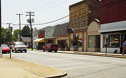
Historic buildings in Emporia include the Belfield-Emporia Historic District, Hicksford-Emporia Historic District, Greensville County Courthouse Complex, Greensville County Training School, H. T. Klugel Architectural Sheet Metal Work Building, Old Merchants and Farmers Bank Building, and Village View, all of which are listed on the National Register of Historic Places. [13]

Geography

Emporia is located at 36°41′34″N77°32′17″W / 36.69278°N 77.53806°W / 36.69278; -77.53806 (36.693018, -77.53809). [14]

According to the United States Census Bureau, the city has a total area of 7.0 square miles (18.1 km2), of which 6.9 square miles (17.9 km2) is land and 0.1 square miles (0.26 km2) (1.1%) is water. [14] The city is located about 65 miles south of Richmond, about 80 miles west of Norfolk and about 60 miles north of Rocky Mount, North Carolina.

Governance

The City of Emporia is governed by a council/manager system. There are seven members of city council elected from districts and a weak mayor elected at large. City council and the mayor are elected to four year terms, in federal election years. Their terms are staggered so that not all members are elected at once. [15]

The City of Emporia is also served by its own Treasurer, Commissioner of the Revenue, Sheriff and General Registrar. The courts system, Greensville County Sheriff, Commonwealth's Attorney and the Public Schools are shared with Greensville County.

Emporia is the location of several voting houses that serve as polling places for Greensville County's Election District I. [16]

Climate

The climate in this area is characterized by hot, humid summers and generally mild to cool winters. According to the Köppen Climate Classification system, Emporia has a humid subtropical climate, abbreviated "Cfa" on climate maps. [17]

Climate data for Emporia, Virginia (1991–2020 normals, extremes 1893–present)
MonthJanFebMarAprMayJunJulAugSepOctNovDecYear
Record high °F (°C)81
(27)
82
(28)
89
(32)
95
(35)
98
(37)
106
(41)
109
(43)
103
(39)
100
(38)
100
(38)
85
(29)
80
(27)
109
(43)
Mean daily maximum °F (°C)50.9
(10.5)
54.2
(12.3)
61.5
(16.4)
71.7
(22.1)
78.8
(26.0)
86.0
(30.0)
89.8
(32.1)
88.3
(31.3)
82.7
(28.2)
72.9
(22.7)
62.6
(17.0)
54.0
(12.2)
71.1
(21.7)
Daily mean °F (°C)39.8
(4.3)
42.4
(5.8)
49.0
(9.4)
58.7
(14.8)
67.2
(19.6)
75.4
(24.1)
79.6
(26.4)
78.1
(25.6)
72.2
(22.3)
60.9
(16.1)
50.4
(10.2)
43.1
(6.2)
59.7
(15.4)
Mean daily minimum °F (°C)28.7
(−1.8)
30.5
(−0.8)
36.6
(2.6)
45.8
(7.7)
55.7
(13.2)
64.8
(18.2)
69.3
(20.7)
67.8
(19.9)
61.6
(16.4)
49.0
(9.4)
38.3
(3.5)
32.3
(0.2)
48.4
(9.1)
Record low °F (°C)−24
(−31)
0
(−18)
12
(−11)
21
(−6)
32
(0)
41
(5)
50
(10)
43
(6)
34
(1)
23
(−5)
12
(−11)
0
(−18)
−24
(−31)
Average precipitation inches (mm)3.40
(86)
2.59
(66)
4.05
(103)
3.43
(87)
3.71
(94)
3.97
(101)
4.86
(123)
5.07
(129)
4.92
(125)
3.47
(88)
3.16
(80)
3.56
(90)
46.19
(1,173)
Average snowfall inches (cm)0.6
(1.5)
0.3
(0.76)
0.0
(0.0)
0.0
(0.0)
0.0
(0.0)
0.0
(0.0)
0.0
(0.0)
0.0
(0.0)
0.0
(0.0)
0.0
(0.0)
0.0
(0.0)
0.5
(1.3)
1.4
(3.6)
Average precipitation days (≥ 0.01 in)10.08.710.39.210.59.510.69.28.97.08.39.9112.1
Average snowy days (≥ 0.1 in)0.30.20.00.00.00.00.00.00.00.00.00.20.7
Source: NOAA [18] [19]

Demographics

Historical population
CensusPop.Note
1890 1,088
1900 1,027−5.6%
1910 2,01896.5%
1920 1,869−7.4%
1930 2,14414.7%
1940 2,73527.6%
1950 5,664107.1%
1960 5,535−2.3%
1970 5,300−4.2%
1980 4,840−8.7%
1990 5,3069.6%
2000 5,6656.8%
2010 5,9274.6%
2020 5,766−2.7%
U.S. Decennial Census [20]
1790-1960 [21] 1900-1990 [22]
1990-2000 [23]

2020 Census

Emporia, Virginia – racial and ethnic composition
(NH = Non-Hispanic)
Note: the US Census treats Hispanic/Latino as an ethnic category. This table excludes Latinos from the racial categories and assigns them to a separate category. Hispanics/Latinos may be of any race.
Race / ethnicityPop. 2010 [24] Pop. 2020 [25] % 2010% 2020
White alone (NH)1,8481,52931.18%26.52%
Black or African American alone (NH)3,6853,63162.17%62.97%
Native American or Alaska Native alone (NH)870.13%0.12%
Asian alone (NH)43500.73%0.87%
Pacific Islander alone (NH)440.07%0.07%
Some other race alone (NH)7370.12%0.64%
Mixed race/multi-racial (NH)701631.18%2.83%
Hispanic or Latino (any race)2623454.42%5.98%
Total5,9275,766100.00%100.00%

2010 Census

As of the 2010 United States Census, there were 5,927 people living in the city. 62.5% were Black or African American, 32.7% White, 0.7% Asian, 0.3% Native American, 0.1% Pacific Islander, 2.1% of some other race and 1.5% of two or more races. 4.4% were Hispanic or Latino (of any race).

As of the census [26] of 2000, there were 5,665 people, 2,226 households, and 1,406 families living in the city. The population density was 821.9 people per square mile (317.3 people/km2). There were 2,412 housing units at an average density of 349.9 units per square mile (135.1 units/km2). The racial makeup of the city was 56.15% Black or African American, 42.45% White, 0.07% Native American, 0.53% Asian, 0.07% Pacific Islander, 0.30% from other races, and 0.42% from two or more races. 1.48% of the population were Hispanic or Latino of any race.

There were 2,226 households, out of which 29.2% had children under the age of 18 living with them, 37.5% were married couples living together, 21.0% had a female householder with no husband present, and 36.8% were non-families. 32.2% of all households were made up of individuals, and 17.4% had someone living alone who was 65 years of age or older. The average household size was 2.43 and the average family size was 3.05.

By percentage of counties or independent cities, Emporia has the highest population of Muslims in the United States as of the 2010 census, with 28.99% of the independent city being adhering Muslims. [27]

In the city, the population was spread out, with 25.2% under the age of 18, 8.1% from 18 to 24, 25.6% from 25 to 44, 20.6% from 45 to 64, and 20.6% who were 65 years of age or older. The median age was 39 years. For every 100 females, there were 83.4 males. For every 100 females age 18 and over, there were 78.1 males.

The median income for a household in the city was $30,333, and the median income for a family was $35,743. Males had a median income of $27,772 versus $21,657 for females. The per capita income for the city was $15,377. About 11.4% of families and 16.0% of the population were below the poverty line, including 21.5% of those under age 18 and 14.5% of those age 65 or over.

Festivals

The Emporia Bicycling Club hosts regular group rides, including the annual Great Peanut ride which attracts hundreds of bicyclists who ride to visit a peanut farm and are treated to hearty meals and live entertainment at camp.

The Virginia Pork Festival was held each second Wednesday in June. Over 40,000 pounds of pork is served alongside alcoholic beverages, hushpuppies and sweet potato french fries. The festival is currently on hold due to lack of funding.

Education

Greensville County Public Schools serves both Emporia and Greensville County. [28] Its high school is Greensville County High School.

Circa 1972 there was an effort by Emporia residents to create a separate school division. On June 22, 1972, the United States Supreme Court denied the creation of the district on a 5-4 basis, with the four dissenters having been appointed by U.S. president Richard Nixon. [29]

Notable people

See also

Related Research Articles

<span class="mw-page-title-main">Southampton County, Virginia</span> County in Virginia, United States

Southampton County is a county located on the southern border of the Commonwealth of Virginia. North Carolina is to the south. As of the 2020 census, the population was 17,996. Its county seat is Courtland.

<span class="mw-page-title-main">Norton, Virginia</span> Independent city in Virginia, United States

Norton is an independent city in the Commonwealth of Virginia, located in the far western tip of the state in Wise County, Virginia. As of the 2020 census, the population was 3,687, making it the least populous city in Virginia. The Bureau of Economic Analysis combines the city of Norton with surrounding Wise County for statistical purposes.

<span class="mw-page-title-main">Manassas Park, Virginia</span> Independent city in Virginia, United States

Manassas Park is an independent city in the U.S. state of Virginia. As of the 2020 census, the population was 17,219. Manassas Park is bordered by the city of Manassas and Prince William County. Manassas Park is a part of the Washington-Arlington-Alexandria, DC-VA-MD-WV Metropolitan Statistical Area.

<span class="mw-page-title-main">Lunenburg County, Virginia</span> County in Virginia, United States

Lunenburg County is a county located in the Commonwealth of Virginia. As of the 2020 census, the population was 11,936. Its county seat is Lunenburg.

<span class="mw-page-title-main">Greensville County, Virginia</span> County in Virginia, United States

Greensville County is a county located in the Commonwealth of Virginia. As of the 2020 census, the population was 11,391. Its county seat is Emporia.

<span class="mw-page-title-main">Grayson County, Virginia</span> County in Virginia, United States

Grayson County is a county located in the southwestern part of the Commonwealth of Virginia. As of the 2020 census, the population was 15,333. Its county seat is Independence. Mount Rogers, the state's highest peak at 5,729 feet (1,746 m), is in Grayson County.

<span class="mw-page-title-main">Covington, Virginia</span> Independent city in Virginia, United States

Covington is an independent city in the Commonwealth of Virginia. As of the 2020 census, the population was 5,737, making it the second-least populous city in Virginia. It is surrounded by Alleghany County, of which it is also the county seat. Located at the confluence of Jackson River and Dunlap Creek, Covington is one of three cities in the Roanoke Regional Partnership. The Bureau of Economic Analysis combines the city of Covington with Alleghany county for statistical purposes.

<span class="mw-page-title-main">Brunswick County, Virginia</span> County in Virginia, United States

Brunswick County is a United States county located on the southern border of the Commonwealth of Virginia. This rural county is known as one of the claimants to be the namesake of Brunswick stew. Brunswick County was created in 1720 from parts of Prince George, Surry and Isle of Wight counties. The county was named for the former Duchy of Brunswick-Lunenburg, the region from which the British monarchs of the House of Hanover originated. As of the 2020 census, the county population was 15,849. The Brunswick county seat is Lawrenceville.

<span class="mw-page-title-main">Northampton County, North Carolina</span> County in North Carolina, United States

Northampton County is a county located in the U.S. state of North Carolina. As of the 2020 census, the population was 17,471. Its county seat is Jackson.

<span class="mw-page-title-main">Wausau, Florida</span> Town in the state of Florida, United States

Wausau is a town in Washington County, Florida, United States. The Town of Wausau is part of the Florida Panhandle in North Florida. The population was 371 at the 2020 census.

<span class="mw-page-title-main">Allen, Kansas</span> City in Lyon County, Kansas

Allen is a city in Lyon County, Kansas, United States. As of the 2020 census, the population of the city was 160.

<span class="mw-page-title-main">Emporia, Kansas</span> City in Lyon County, Kansas, United States

Emporia is a city in and the county seat of Lyon County, Kansas, United States. As of the 2020 census, the population of the city was 24,139. Emporia lies between Topeka and Wichita at the intersection of U.S. Route 50 with Interstates 335 and 35 on the Kansas Turnpike. Emporia is also a college town, home to Emporia State University and Flint Hills Technical College. It is home of two annual sporting events: Unbound Gravel and Dynamic Discs Open.

<span class="mw-page-title-main">Weldon, North Carolina</span> Town in North Carolina, United States

Weldon is a town in Halifax County, North Carolina, United States. The population was 1,655 at the 2010 census. It is part of the Roanoke Rapids, North Carolina Micropolitan Statistical Area.

<span class="mw-page-title-main">Martin, Tennessee</span> City in Tennessee, United States

Martin is a city in Weakley County, Tennessee, United States. The population was 10,825 according to the 2020 census. The city is the home of the University of Tennessee at Martin.

<span class="mw-page-title-main">Meridian, Texas</span> City in Texas, United States

Meridian is a city and the county seat of Bosque County in central Texas, United States. It is forty-seven miles northwest of Waco. The population was 1,493 at the 2010 census.

<span class="mw-page-title-main">Spearman, Texas</span> City in Texas, United States

Spearman is a city in and the county seat of Hansford County, Texas, United States. As of the 2010 census, the city population was 3,368. It is known for its collection of windmills from the J.B. Buchanan windmill collection.

<span class="mw-page-title-main">Moundsville, West Virginia</span> City in West Virginia, United States

Moundsville is a city in and the county seat of Marshall County, West Virginia, United States, along the Ohio River. The population was 8,122 at the 2020 census. It is part of the Wheeling metropolitan area. The city was named for the nearby ancient Grave Creek Mound, constructed 250 to 100 BC by indigenous people of the Adena culture.

<span class="mw-page-title-main">Jarratt, Virginia</span> Town in Virginia, United States

Jarratt is a town in Greensville and Sussex counties in the U.S. state of Virginia. The population was 652 at the 2020 census. In 1848, Jarratt was a stop on the Petersburg Railroad. Jaratt was incorporated in 1938.

<span class="mw-page-title-main">Sussex County, Virginia</span> County in Virginia, United States

Sussex County is a rural county located in the southeast of the Commonwealth of Virginia. As of the 2020 census, the population was 10,829. Its county seat is Sussex. It was formed in 1754 from Surry County. The county is named after the county of Sussex, England.

<span class="mw-page-title-main">Hicksford–Emporia Historic District</span> Historic district in Virginia, United States

Hicksford–Emporia Historic District, also known as Emporia, is a national historic district located at Emporia, Virginia. The district includes 36 contributing buildings and 2 contributing objects in the Hicksford section of Emporia. In 1848, Hicksford was a stop on the Petersburg Railroad. In 1887, the neighboring towns of Hicksford and Belfield merged to form the town of Emporia. The district generally consists of late 19th century or early 20th century, when Hicksford–Emporia began to evolve from a small agricultural outpost to a large commercial and governmental center. Located at the heart of the district is the separately listed Greensville County Courthouse Complex. Other notable buildings include the Citizen's National Bank, the Widow's Son's Masonic Lodge (1905), First Presbyterian Church (1907-1908), Emporia Elementary School, Emporia Armory (mid-1930s), Greensville County Auditorium (1934), and Emporia Post Office (1938). The Old Merchants and Farmers Bank Building is also separately listed.

References

  1. "2019 U.S. Gazetteer Files". United States Census Bureau. Retrieved August 7, 2020.
  2. "U.S. Census website". United States Census Bureau . Retrieved January 31, 2008.
  3. "US Board on Geographic Names". United States Geological Survey. October 25, 2007. Retrieved January 31, 2008.
  4. "Find a County". National Association of Counties. Archived from the original on May 31, 2011. Retrieved June 7, 2011.
  5. "Emporia city, Emporia city, Virginia". United States Census Bureau . Retrieved January 26, 2022.
  6. 1 2 "Robert Hicks". Native American Roots. Retrieved May 6, 2021.
  7. "Tarleton's Movements - Emporia - VA - US - Historical Marker Project" . Retrieved April 11, 2017.
  8. Travis C. McDonald Jr., Emporia: A Centennial Retrospective 1887-1987' (Emporia Centennial Committee 1987)
  9. McDonald p. 8
  10. "VA-UM46 Hicksford Raid" . Retrieved April 11, 2017.
  11. "Benjamin D. Tillar, Jr. UM-39 - Marker History". January 1, 1853. Retrieved April 11, 2017.
  12. McDonald pp. 8-16
  13. "National Register Information System". National Register of Historic Places . National Park Service. July 9, 2010.
  14. 1 2 "US Gazetteer files: 2010, 2000, and 1990". United States Census Bureau. February 12, 2011. Retrieved April 23, 2011.
  15. "City Council | Emporia VA".
  16. "Greensville, VA".
  17. "Emporia, Virginia Köppen Climate Classification (Weatherbase)" . Retrieved April 11, 2017.
  18. "NowData – NOAA Online Weather Data". National Oceanic and Atmospheric Administration. Retrieved July 5, 2021.
  19. "Station: Emporia 1 WNW, VA". U.S. Climate Normals 2020: U.S. Monthly Climate Normals (1991-2020). National Oceanic and Atmospheric Administration. Retrieved July 5, 2021.
  20. "Census of Population and Housing from 1790". US Census Bureau . Retrieved January 24, 2022.
  21. "Historical Census Browser". University of Virginia Library. Retrieved January 2, 2014.
  22. "Population of Counties by Decennial Census: 1900 to 1990". United States Census Bureau. Retrieved January 2, 2014.
  23. "Census 2000 PHC-T-4. Ranking Tables for Counties: 1990 and 2000" (PDF). United States Census Bureau. Archived (PDF) from the original on October 9, 2022. Retrieved January 2, 2014.
  24. "P2 HISPANIC OR LATINO, AND NOT HISPANIC OR LATINO BY RACE - 2010: DEC Redistricting Data (PL 94-171) - Emporia city, Virginia". United States Census Bureau .
  25. "P2 HISPANIC OR LATINO, AND NOT HISPANIC OR LATINO BY RACE - 2020: DEC Redistricting Data (PL 94-171) - Emporia city, Virginia". United States Census Bureau .
  26. "U.S. Census website". United States Census Bureau . Retrieved May 14, 2011.
  27. "Muslim Estimate Counties (2010) | QuickLists | The Association of Religion Data Archives". www.thearda.com. Retrieved May 15, 2017.
  28. Gabay, Barry (October 16, 2015). "SOCIOECONOMIC INTEGRATION AND THE GREATER RICHMOND SCHOOL DISTRICT: THE FEASIBILITY OF INTERDISTRICT CONSOLIDATION" (PDF). University of Richmond Law Review . 51: 397–438. Archived (PDF) from the original on October 9, 2022. - page cited: 436.
  29. "Splinter School District Dispute In Texas Reaches a U.S. Court". The New York Times . September 19, 1972. Retrieved August 10, 2019.

36°41′35″N77°32′17″W / 36.693018°N 77.53809°W / 36.693018; -77.53809