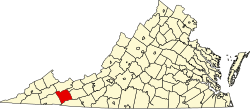
Smyth County | |
---|---|
Coordinates: 36°50′N81°32′W / 36.84°N 81.53°W | |
Country | United States |
State | Virginia |
Founded | 1832 |
Named for | Alexander Smyth |
Seat | Marion |
Largest town | Marion |
Area | |
• Total | 452 sq mi (1,170 km2) |
• Land | 451 sq mi (1,170 km2) |
• Water | 1.4 sq mi (4 km2) 0.3% |
Population (2020) | |
• Total | 29,800 |
• Density | 66/sq mi (25/km2) |
Time zone | UTC−5 (Eastern) |
• Summer (DST) | UTC−4 (EDT) |
Congressional district | 9th |
Website | www |
Smyth County is a county located in the U.S. state of Virginia. As of the 2020 census, the population was 29,800. [1] Its county seat is Marion. [2]
Smyth County was formed on February 23, 1832, from Washington and Wythe counties. The county is named after Alexander Smyth, a general during the War of 1812 who was elected to the state Senate, House of Delegates, and as a Representative to the United States Congress.
According to the U.S. Census Bureau, the county has a total area of 452 square miles (1,170 km2), of which 451 square miles (1,170 km2) is land and 1.4 square miles (3.6 km2) (0.3%) is water. [3] Smyth County is one of the 423 counties served by the Appalachian Regional Commission, [4] and it is identified as part of "Greater Appalachia" by Colin Woodard in his book American Nations: A History of the Eleven Rival Regional Cultures of North America . [5]
Census | Pop. | Note | %± |
---|---|---|---|
1840 | 6,522 | — | |
1850 | 8,162 | 25.1% | |
1860 | 8,952 | 9.7% | |
1870 | 8,898 | −0.6% | |
1880 | 12,160 | 36.7% | |
1890 | 13,360 | 9.9% | |
1900 | 17,121 | 28.2% | |
1910 | 20,326 | 18.7% | |
1920 | 22,125 | 8.9% | |
1930 | 25,125 | 13.6% | |
1940 | 28,861 | 14.9% | |
1950 | 30,187 | 4.6% | |
1960 | 31,066 | 2.9% | |
1970 | 31,349 | 0.9% | |
1980 | 33,366 | 6.4% | |
1990 | 32,370 | −3.0% | |
2000 | 33,081 | 2.2% | |
2010 | 32,208 | −2.6% | |
2020 | 29,800 | −7.5% | |
U.S. Decennial Census [6] 1790–1960 [7] 1900–1990 [8] 1990–2000 [9] 2010 [10] 2020 [11] |
Race / Ethnicity | Pop 2010 [10] | Pop 2020 [11] | % 2010 | % 2020 |
---|---|---|---|---|
White alone (NH) | 30,642 | 27,762 | 95.14% | 93.16% |
Black or African American alone (NH) | 630 | 408 | 1.96% | 1.37% |
Native American or Alaska Native alone (NH) | 41 | 36 | 0.13% | 0.12% |
Asian alone (NH) | 82 | 104 | 0.25% | 0.35% |
Pacific Islander alone (NH) | 3 | 1 | 0.01% | 0.00% |
Some Other Race alone (NH) | 18 | 49 | 0.06% | 0.16% |
Mixed Race/Multi-Racial (NH) | 265 | 882 | 0.82% | 2.96% |
Hispanic or Latino (any race) | 527 | 558 | 1.64% | 1.87% |
Total | 32,208 | 29,800 | 100.00% | 100.00% |
Note: the US Census treats Hispanic/Latino as an ethnic category. This table excludes Latinos from the racial categories and assigns them to a separate category. Hispanics/Latinos can be of any race.
As of the census [12] of 2000, there were 33,081 people, 13,493 households, and 9,607 families residing in the county. The population density was 73 inhabitants per square mile (28/km2). There were 15,111 housing units at an average density of 33 units per square mile (13 units/km2). The racial makeup of the county was 96.86% White, 1.87% Black or African American, 0.15% Native American, 0.18% Asian, 0.32% from other races, and 0.60% from two or more races. 0.86% of the population were Hispanic or Latino of any race.
There were 13,493 households, out of which 29.20% had children under the age of 18 living with them, 55.70% were married couples living together, 11.20% had a female householder with no husband present, and 28.80% were non-families. 26.00% of all households were made up of individuals, and 12.50% had someone living alone who was 65 years of age or older. The average household size was 2.37 and the average family size was 2.83.
In the county, the population was spread out, with 21.60% under the age of 18, 8.00% from 18 to 24, 28.10% from 25 to 44, 26.00% from 45 to 64, and 16.30% who were 65 years of age or older. The median age was 40 years. For every 100 females there were 93.80 males. For every 100 females aged 18 and over, there were 90.50 males.
The median income for a household in the county was $30,083, and the median income for a family was $36,392. Males had a median income of $26,698 versus $19,712 for females. The per capita income for the county was $16,105. About 9.90% of families and 13.30% of the population were below the poverty line, including 15.20% of those under age 18 and 14.00% of those age 65 or over.
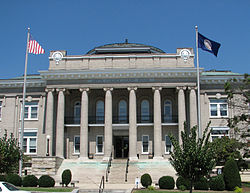
The Smyth County Tourism Association was formed in April 2006 to promote sustainable tourism development and manages the operation of the state-certified H.L. Bonham Regional Development and Tourism Center. The organization markets the area through https://visitsmythcountyva.com/
Year | Republican | Democratic | Third party(ies) | |||
---|---|---|---|---|---|---|
No. | % | No. | % | No. | % | |
2024 | 11,521 | 79.63% | 2,805 | 19.39% | 142 | 0.98% |
2020 | 10,963 | 77.55% | 3,008 | 21.28% | 165 | 1.17% |
2016 | 9,750 | 75.64% | 2,665 | 20.67% | 475 | 3.69% |
2012 | 8,379 | 65.58% | 4,171 | 32.64% | 227 | 1.78% |
2008 | 7,817 | 63.54% | 4,239 | 34.46% | 246 | 2.00% |
2004 | 7,906 | 64.18% | 4,143 | 33.63% | 270 | 2.19% |
2000 | 6,580 | 56.05% | 4,836 | 41.19% | 324 | 2.76% |
1996 | 4,966 | 42.74% | 4,990 | 42.95% | 1,663 | 14.31% |
1992 | 6,128 | 47.39% | 4,924 | 38.08% | 1,879 | 14.53% |
1988 | 7,446 | 63.49% | 3,989 | 34.02% | 292 | 2.49% |
1984 | 8,593 | 67.08% | 4,102 | 32.02% | 116 | 0.91% |
1980 | 6,033 | 50.86% | 5,335 | 44.98% | 493 | 4.16% |
1976 | 5,032 | 47.29% | 5,246 | 49.30% | 363 | 3.41% |
1972 | 6,409 | 72.27% | 2,280 | 25.71% | 179 | 2.02% |
1968 | 5,297 | 54.32% | 2,631 | 26.98% | 1,823 | 18.70% |
1964 | 3,830 | 48.16% | 4,113 | 51.72% | 9 | 0.11% |
1960 | 4,256 | 59.62% | 2,864 | 40.12% | 18 | 0.25% |
1956 | 4,771 | 66.23% | 2,374 | 32.95% | 59 | 0.82% |
1952 | 3,694 | 64.98% | 1,972 | 34.69% | 19 | 0.33% |
1948 | 2,897 | 60.08% | 1,750 | 36.29% | 175 | 3.63% |
1944 | 2,726 | 54.53% | 2,266 | 45.33% | 7 | 0.14% |
1940 | 2,134 | 46.70% | 2,420 | 52.95% | 16 | 0.35% |
1936 | 2,067 | 46.75% | 2,337 | 52.86% | 17 | 0.38% |
1932 | 1,843 | 43.92% | 2,287 | 54.50% | 66 | 1.57% |
1928 | 2,751 | 58.68% | 1,937 | 41.32% | 0 | 0.00% |
1924 | 2,232 | 53.50% | 1,907 | 45.71% | 33 | 0.79% |
1920 | 1,883 | 55.16% | 1,516 | 44.41% | 15 | 0.44% |
1916 | 1,321 | 53.63% | 1,134 | 46.04% | 8 | 0.32% |
1912 | 609 | 27.46% | 1,022 | 46.08% | 587 | 26.47% |
Montgomery County is a county located in the Valley and Ridge area of the U.S. state of Virginia. As population in the area increased, Montgomery County was formed in 1777 from Fincastle County, which in turn had been taken from Botetourt County. As of the 2020 census, the population was 99,721. Its county seat is Christiansburg, and Blacksburg is the largest town. Montgomery County is part of the Blacksburg-Christiansburg metropolitan area. It is dominated economically by the presence of Virginia Tech, Virginia's third largest public university, which is the county's largest employer.
Perry County is a county located in the Black Belt region in the central part of the U.S. state of Alabama. As of the 2020 census, the population was 8,511. Its county seat is Marion. The county was established in 1819 and is named in honor of Commodore Oliver Hazard Perry of Rhode Island and the United States Navy. As of 2020, Perry County was the only county in Alabama, and one of 40 in the United States, not to have access to any wired broadband connections.
Wythe County is a county located in the southwestern part of the U.S. state of Virginia. As of the 2020 census, the population was 28,290. Its county seat is Wytheville.
Washington County is a county located in the Commonwealth of Virginia. As of the 2020 census, the population was 53,935. Its county seat is Abingdon. Washington County is part of the Kingsport–Bristol–Bristol, TN-VA Metropolitan Statistical Area, which is a component of the Johnson City–Kingsport–Bristol, TN-VA Combined Statistical Area, commonly known as the "Tri-Cities" region, which includes Bristol TN-VA, Kingsport TN, and Johnson City TN.
Russell County is a county located in the Commonwealth of Virginia. As of the 2020 census, the population was 25,781. Its county seat is Lebanon.
Richmond County is a county located on the Northern Neck in the U.S. state of Virginia. As of the 2020 census, the population sits at 8,923. Its county seat is Warsaw. The rural county should not be confused with the large city and state capital Richmond, Virginia. It was formed in 1692 when the first Rappahannock County was divided to form Richmond County and Essex County.
Pulaski County is a county located in the southwestern part of the U.S. state of Virginia. As of the 2020 census, the population was 33,800. Its county seat is Pulaski. Pulaski County is part of the Blacksburg–Christiansburg, VA Metropolitan Statistical Area.
Lancaster County is a county located on the Northern Neck in the Commonwealth of Virginia. As of the 2020 census, the population sits at 10,919. Its county seat is Lancaster.
Grayson County is a county located in the southwestern part of the Commonwealth of Virginia. As of the 2020 census, the population was 15,333. Its county seat is Independence. Mount Rogers, the state's highest peak at 5,729 feet (1,746 m), is in Grayson County.
Giles County is a county located in the U.S. state of Virginia on the West Virginia state line. As of the 2020 census, the population was 16,787. Its county seat is Pearisburg.
Dickenson County is a county located in the Commonwealth of Virginia. As of the 2020 census, the population was 14,124. Its county seat is Clintwood.
Craig County is a county located in the Commonwealth of Virginia. As of the 2020 census, the population was 4,892. Its county seat is New Castle.
Buchanan County is a United States county in far western Virginia, the only county in the state to border both West Virginia and Kentucky. The county is part of the Southwest Virginia region and lies in the rugged Appalachian Plateau portion of the Appalachian Mountains. Its county seat is Grundy. Buchanan County was established in 1858 from parts of Russell and Tazewell counties, and it was named in honor of then-President James Buchanan. Local pronunciation differs from that of the 15th president's surname; here the county is pronounced as "Búh-can-nin". In 1880, part of Buchanan County was taken to form Dickenson County.
Bland County is a county located in the southwestern portion of the Commonwealth of Virginia. The county seat is the unincorporated area of Bland. At the 2020 census, the population was 6,270.
Bath County is a United States county on the central western border of the Commonwealth of Virginia, on the West Virginia state line. As of the 2020 census, the population was 4,209, the second-least populous county in Virginia. Bath's county seat is Warm Springs.
Grundy is a town in Buchanan County, Virginia, United States, an area located within the Appalachian Mountains region. It is the county seat of Buchanan County. The town is home to the Appalachian School of Law. The population was 875 at the 2020 census.
Chilhowie is a town in Smyth County, Virginia, United States, on the Middle Fork of the Holston River. The population was 1,781 at the 2010 census. The name Chilhowie is said to come from a Cherokee word meaning "valley of many deer". It is also notable for having only one traffic light in the entire city. I-81 runs through Chilhowie. It is located at exit 35.
Saltville is a town in Smyth and Washington counties in the U.S. state of Virginia. The population was 1,824 at the 2020 census. It is part of the Kingsport–Bristol (TN)–Bristol (VA) Metropolitan Statistical Area, which is a component of the Johnson City–Kingsport–Bristol, TN-VA Combined Statistical Area – commonly known as the "Tri-Cities" region.
Tazewell County is a county located in the southwestern portion of the U.S. state of Virginia. As of the 2020 census, the population was 40,429. Its county seat is Tazewell.
Carroll County is a United States county located in the southwestern part of the Commonwealth of Virginia. Roughly one fifth of the county lies in the Virginia Piedmont region, while the rest is part of the Appalachian Mountains. The county seat and only town is Hillsville.