Lick Skillet, Virginia | |
|---|---|
Unincorporated community | |
 Lick Skillet, Virginia  Lick Skillet, Virginia | |
| Coordinates: 36°53′39″N81°47′28″W / 36.89417°N 81.79111°W | |
| Country | United States |
| State | Virginia |
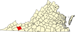
| County | Smyth |
| Elevation | 1,929 ft (588 m) |
| Time zone | UTC-5 (Eastern (EST)) |
| • Summer (DST) | UTC-4 (EDT) |
| GNIS feature ID | 1484836 [1] |
Lick Skillet is an unincorporated community in Smyth County, Virginia, United States. [1] According to local legend, Lick Skillet's name is derived from the roads around the community which form the appearance of a skillet. [2]