Seven Mile Ford, Virginia

Last updated
General store SevenMileFordVA.jpg
General store

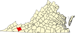
Seven Mile Ford is a census-designated place (CDP) in Smyth County, Virginia, United States. The population as of the 2010 Census was 783. [1] It obtained its current name as a result of being a river crossing seven miles from the Royal Oak Fort in Marion, Virginia. U.S. Hwy 11 passes through the center of the community, which is approximately 4 miles (6.4 km) from Chilhowie. [2]

Aspenvale Cemetery was listed on the National Register of Historic Places in 1980. [3]

Related Research Articles

Washington County, Virginia U.S. county in Virginia

Washington County is a county located in the Commonwealth of Virginia. As of the 2010 census, the population was 54,876. Its county seat is Abingdon.

Smyth County, Virginia U.S. county in Virginia

Smyth County is a county located in the U.S. state of Virginia. As of the 2010 census, the population was 32,208. Its county seat is Marion.

Iberville Parish, Louisiana Parish in Louisiana

Iberville Parish is a parish located south of Baton Rouge in the U.S. state of Louisiana. As of the 2010 census, the population was 33,387. Its seat is Plaquemine. The parish was formed in 1807.

Chester, South Carolina City in South Carolina, United States

Chester is a small rural city in Chester County, South Carolina, United States. The population was 5,607 at the 2010 census, down from 6,476 at the 2000 census. It is the county seat of Chester County.

Newberry, South Carolina City in South Carolina, United States

Newberry is a city in Newberry County, South Carolina, United States, in the Piedmont 43 miles northwest of Columbia. The charter was adopted in 1894. The population was 10,277 at the 2010 census. It is the county seat of Newberry County; at one time it was called Newberry Courthouse.

Madison Heights, Virginia CDP in Virginia, United States

Madison Heights is a census-designated place (CDP) in Amherst County, Virginia, United States. The population was 11,285 at the 2010 census. It is part of the Lynchburg Metropolitan Statistical Area.

Brookneal, Virginia Town in Virginia, United States

Brookneal is an incorporated town in Campbell County, Virginia, United States. The population was 1,112 as of the 2010 census. It is part of the Lynchburg Metropolitan Statistical Area.

McKenney, Virginia Town in Virginia, United States

McKenney is an incorporated town in Dinwiddie County, Virginia, United States. The population was 483 at the 2010 census.

Boydton, Virginia Town in Virginia, United States

Boydton is a town in Mecklenburg County, Virginia, United States. The population was 431 at the 2010 census. It is the county seat of Mecklenburg County, and it is near Kerr Lake.

Marion, Virginia Town in Virginia, United States

Marion is a town in and the county seat of Smyth County, Virginia, United States. Conveniently positioned upon Interstate 81, Marion is easily accessible. Located in the Blue Ridge portion of the Southern Appalachian mountains in Southwest Virginia, the general Marion area is well known for its scenic beauty. The town is named for American Revolutionary War officer Francis Marion. The town limits had a population of approximately 6,000, per 2020 Census estimates. However, an additional 9,000 residents in unincorporated Smyth County have Marion mailing addresses, giving the Marion, VA ZIP code (24354) a population of over 15,000, which is about half of the county's total population.

Glade Spring, Virginia Town in Virginia, United States

Glade Spring is a town in Washington County, Virginia, United States. The population was 1,456 at the 2010 census. It is part of the Kingsport–Bristol (TN)–Bristol (VA) Metropolitan Statistical Area, which is a component of the Johnson City–Kingsport–Bristol, TN-VA Combined Statistical Area – commonly known as the "Tri-Cities" region.

Saluda, Virginia

Saluda is a census-designated place (CDP) in and the county seat of Middlesex County, Virginia, United States. The population as of the 2010 Census was 769.

Sussex is a census-designated place (CDP) in and the county seat of Sussex County, Virginia, United States. The population as of the 2010 Census was 256.

New Kent, Virginia

New Kent is a census-designated place (CDP) in and the county seat of New Kent County, Virginia, United States. The population as of the 2010 Census was 239.

Nottoway, Virginia

Nottoway, or Nottoway Court House, is a census-designated place (CDP) in and the county seat of Nottoway County, Virginia, United States. The population as of the 2010 Census was 84.

Liberty Township, Parke County, Indiana Township in Indiana, United States

Liberty Township is one of thirteen townships in Parke County, Indiana, United States. As of the 2010 census, its population was 739 and it contained 324 housing units.

Raccoon Township, Parke County, Indiana Township in Indiana, United States

Raccoon Township is one of thirteen townships in Parke County, Indiana, United States. As of the 2010 census, its population was 659 and it contained 345 housing units.

Oil Township, Perry County, Indiana Township in Indiana, United States

Oil Township is one of seven townships in Perry County, Indiana, United States. As of the 2010 census, its population was 2,546 and it contained 531 housing units.

Center Township, Rush County, Indiana Township in Indiana, United States

Center Township is one of twelve townships in Rush County, Indiana. As of the 2010 census, its population was 780 and it contained 316 housing units.

Belspring, Virginia Census-designated place in Virginia, United States

Belspring is a census-designated place (CDP) in Pulaski County, Virginia, United States, located at an elevation of 1,778 feet (542 m) above sea level. It has the ZIP Code 24058 and the area code 540. The population of the CDP was 256 at the 2010 Census.

References

  1. Virginia Trend Report 2: State and Complete Places (Sub-state 2010 Census Data). Archived 2017-08-16 at the Wayback Machine Missouri Census Data Center. Accessed 2011-06-08.
  2. Smyth County History Archived 2007-08-09 at the Wayback Machine
  3. "National Register Information System". National Register of Historic Places . National Park Service. July 9, 2010.

Coordinates: 36°48′37″N81°37′46″W / 36.81028°N 81.62944°W / 36.81028; -81.62944