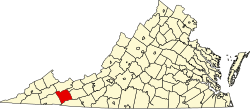
Adwolfe, Virginia

Last updated
Adwolfe, Virginia
CDP
Coordinates: 36°47′1″N81°35′21″W / 36.78361°N 81.58917°W / 36.78361; -81.58917 Coordinates: 36°47′1″N81°35′21″W / 36.78361°N 81.58917°W / 36.78361; -81.58917
CountryUnited States
State Virginia
County Smyth
Area
  Total7.9 sq mi (20.3 km2)
  Land7.9 sq mi (20.3 km2)
  Water0.0 sq mi (0.0 km2)
Elevation
2,329 ft (710 m)
Population
 (2010)
  Total1,530
Time zone UTC−5 (Eastern (EST))
  Summer (DST) UTC−4 (EDT)
FIPS code 51-00468 [1]
GNIS feature ID1495185 [2]

Adwolfe is a census-designated place (CDP) in Smyth County, Virginia, United States. The population was 1,530 at the 2010 census.

Contents

Geography

Adwolfe is located at 36°47′1″N81°35′21″W / 36.78361°N 81.58917°W / 36.78361; -81.58917 (36.783641, 81.589270). [3]

According to the United States Census Bureau, the CDP has a total area of 7.8 square miles (20.3 km2), all of it land.

Demographics

As of the census [1] of 2000, there were 1,457 people, 587 households, and 459 families residing in the CDP. The population density was 185.6 people per square mile (71.7/km2). There were 617 housing units at an average density of 78.6/sq mi (30.3/km2). The racial makeup of the CDP was 98.22% White, 0.14% African American, 0.21% Asian, 0.48% from other races, and 0.96% from two or more races. Hispanic or Latino of any race were 1.17% of the population.

There were 587 households, out of which 29.0% had children under the age of 18 living with them, 65.1% were married couples living together, 9.2% had a female householder with no husband present, and 21.8% were non-families. 18.4% of all households were made up of individuals, and 7.5% had someone living alone who was 65 years of age or older. The average household size was 2.48 and the average family size was 2.79.

In the CDP, the population was spread out, with 20.1% under the age of 18, 8.3% from 18 to 24, 29.0% from 25 to 44, 29.0% from 45 to 64, and 13.5% who were 65 years of age or older. The median age was 41 years. For every 100 females, there were 99.6 males. For every 100 females age 18 and over, there were 98.6 males.

The median income for a household in the CDP was $37,117, and the median income for a family was $42,941. Males had a median income of $29,861 versus $20,038 for females. The per capita income for the CDP was $16,880. About 3.6% of families and 7.8% of the population were below the poverty line, including 6.9% of those under age 18 and 4.5% of those age 65 or over.

Related Research Articles

Kaibab, Arizona CDP in Coconino and Mohave Counties, Arizona

Kaibab is a census-designated place (CDP) in Coconino and Mohave counties in the U.S. state of Arizona. It is coterminous with the Kaibab Indian Reservation. The population was 124 at the 2010 census.

Wilhoit, Arizona CDP in Yavapai County, Arizona

Wilhoit is a census-designated place (CDP) in Yavapai County, Arizona, United States. The population was 664 at the 2000 census.

South Bradenton, Florida CDP in Florida, United States

South Bradenton is a census-designated place (CDP) in Manatee County, Florida, United States. The population was 21,587 at the 2000 census. It is part of the Bradenton–Sarasota–Venice Metropolitan Statistical Area.

Fairview Shores, Florida Census-designated place in Florida, United States

Fairview Shores is a census-designated place and an unincorporated area in Orange County, Florida, United States. The population was 10,239 at the 2010 census. It is part of the Orlando–Kissimmee–Sanford, Florida Metropolitan Statistical Area.

Crooked Lake Park, Florida Census-designated place in Florida, United States

Crooked Lake Park is a census-designated place (CDP) in Polk County, Florida, United States. The population was 1,682 at the 2000 census. It is part of the Lakeland–Winter Haven Metropolitan Statistical Area.

Bliss Corner, Massachusetts Census-designated place in Massachusetts, United States

Bliss Corner is a census-designated place (CDP) in the town of Dartmouth in Bristol County, Massachusetts, United States. The population was 5,280 at the 2010 census.

Marion Center, Massachusetts Census-designated place in Massachusetts, United States

Marion Center is a census-designated place (CDP) in the town of Marion in Plymouth County, Massachusetts, United States. The population was 1,111 at the 2010 census.

Lake Katrine, New York CDP in New York, United States

Lake Katrine is a hamlet in Ulster County, New York, United States. The population was 2,397 at the 2010 census.

South Weldon, North Carolina Census-designated place in North Carolina, United States

South Weldon is an unincorporated community and census-designated place (CDP) in Halifax County, North Carolina, in the United States. As of the 2010 census, the CDP population was 705. It is part of the Roanoke Rapids, North Carolina Micropolitan Statistical Area.

Hays, North Carolina CDP in North Carolina, United States

Hays is a census-designated place (CDP) in Wilkes County, North Carolina, United States. The population was 1,731 at the 2000 census. North Wilkes High School, one of Wilkes County's four public high schools, is located in Hays.

Fort McKinley is an unincorporated community in Harrison Township in Montgomery County, Ohio, United States. It was delineated as a census-designated place (CDP) at the 2000 census, when its population was 3,989. It was not delineated as a CDP for the 2010 census.

Rosemount, Ohio Census-designated place in Ohio, United States

Rosemount is a census-designated place (CDP) in Clay Township, Scioto County, Ohio, United States. The population was 2,112 at the 2010 census.

Richboro, Pennsylvania Census-designated place in Pennsylvania, United States

Richboro is a census-designated place (CDP) in Northampton Township, Bucks County, Pennsylvania, United States. The population was 6,563 at the 2010 census.

Thompsonville, Pennsylvania Census-designated place in Pennsylvania, United States

Thompsonville is a census-designated place (CDP) in Washington County, Pennsylvania, United States. The population was 3,520 at the 2010 census.

Spry, Pennsylvania CDP in Pennsylvania, United States

Spry is a census-designated place (CDP) in York County, Pennsylvania, United States. The population was 4,891 at the 2010 census.

Saxon, South Carolina CDP in South Carolina, United States

Saxon is a census-designated place (CDP) in Spartanburg County, South Carolina, United States. The population was 3,424 at the 2010 census.

Buffalo, South Carolina CDP in South Carolina, United States

Buffalo is a census-designated place (CDP) in Union County, South Carolina, United States. The population was 1,266 at the 2010 United States Census.

Normanna, Texas Census-designated place in Texas, United States

Normanna is a census-designated place in Bee County, Texas, United States. The population was 113 at the 2010 census.

Atkins, Virginia CDP in Virginia, United States

Atkins is a census-designated place (CDP) in Smyth County, Virginia, United States. The population was 1,143 at the 2010 census.

Gilbert Creek, West Virginia CDP in West Virginia, United States

Gilbert Creek is a census-designated place (CDP) in Mingo County, West Virginia, United States. The population was 1,090 at the 2010 census. The community takes its name from nearby Gilbert Creek.

References

  1. 1 2 "U.S. Census website". United States Census Bureau . Retrieved 2008-01-31.
  2. "US Board on Geographic Names". United States Geological Survey. 2007-10-25. Retrieved 2008-01-31.
  3. "US Gazetteer files: 2010, 2000, and 1990". United States Census Bureau. 2011-02-12. Retrieved 2011-04-23.