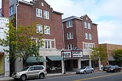
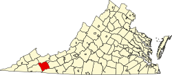
Marion, Virginia

Last updated

Town of Marion, Virginia
LincolnTheatreMarionVA.jpg
The Lincoln Theatre in Marion, Virginia.
Marion Seal.PNG
Motto: 
America's Coolest Hometown
USA Virginia location map.svg
Red pog.svg
Marion
Location in the Commonwealth of Virginia
Usa edcp location map.svg
Red pog.svg
Marion
Marion (the United States)
Coordinates: 36°50′N81°31′W / 36.833°N 81.517°W / 36.833; -81.517
Country United States
State Virginia
County Smyth
Area
[1]
   Town
5.16 sq mi (10.76 km2)
  Land5.13 sq mi (10.69 km2)
  Water0.03 sq mi (0.08 km2)
Elevation
2,500 ft (800 m)
Population
 (2020)
   Town
6,022
  Density1,347.31/sq mi (537.98/km2)
   Metro
Approximately 14,500 total population
Time zone UTC−5 (EST)
  Summer (DST) UTC−4 (EDT)
ZIP code
24354
Area code 276
FIPS code 51-49464 [2]
GNIS feature ID1498513 [3]
Website www.marionva.org

Marion is a town in, and the county seat of, Smyth County, Virginia, United States. It is positioned upon Interstate 81, in the Blue Ridge portion of the Southern Appalachian mountains in Southwest Virginia. [4] The town is named for American Revolutionary War officer Francis Marion. The town limits had a population of approximately 6,000, per 2020 Census estimates. However, together with the neighborhoods, an additional 9,000 residents residing in unincorporated Smyth County have Marion mailing addresses, granting the Marion, VA ZIP code (24354) a total population of about 14,500, which is around half of the county's total population.

Contents

Geography

Marion, Virginia is the location of two large side-by-side ground storage water tower tanks, which are separately labeled "HOT" (in red letters) and "COLD" (in blue). The landmarks, positioned just off of Marion exit 47, are visible to both north and south bound Interstate 81 traffic lanes.

According to the United States Census Bureau, the town has a total area of 5.2 square miles (10.7 km2), all of it land.

Marion is home to Hungry Mother State Park, one of the six original Virginia State Parks from the 1930s.

Demographics

Historical population
CensusPop.Note
1860 445
1870 368−17.3%
1880 919149.7%
1890 1,65179.7%
1900 2,04523.9%
1910 2,72733.3%
1920 3,25319.3%
1930 4,15627.8%
1940 5,17724.6%
1950 6,98234.9%
1960 8,38520.1%
1970 8,158−2.7%
1980 7,287−10.7%
1990 6,858−5.9%
2000 6,503−5.2%
2010 6,292−3.2%
2020 6,022−4.3%
source: [5] [6]

2020 census

Marion Racial Composition [7]
RaceNum.Perc.
White 5,21387.17%
Black or African American 2614.54%
Native American 120.21%
Asian 591.03%
Pacific Islander 10.02%
Other/Mixed 2243.89%
Hispanic or Latino 1813.15%

As of the 2020 United States Census, there were 6,022 people, 2,573 households, and 1,394 families residing within the town limits.

2000 census

As of the census [2] of 2000, there were 6,503 people, 2,677 households, and 1,648 families residing in the town. The population density was 1,528.3 people per square mile (590.7/km2). There were 2,865 housing units at an average density of 689.6 per square mile (266.6/km2). The racial makeup of the town was 91.98% White, 5.94% African American, 0.24% Native American, 0.52% Asian, 0.02% Pacific Islander, 0.38% from other races, and 0.93% from two or more races. Hispanic or Latino of any race were 1.13% of the population.

There were 2,677 households, out of which 24.4% had children under the age of 18 living with them, 42.6% were married couples living together, 14.3% had a female householder with no husband present, and 39.0% were non-families. 36.5% of all households were made up of individuals, and 19.3% had someone living alone who was 65 years of age or older. The average household size was 2.13 and the average family size was 2.76.

In the town, the population was spread out, with 19.4% under the age of 18, 9.7% from 18 to 24, 26.0% from 25 to 44, 24.2% from 45 to 64, and 20.7% who were 65 years of age or older. The median age was 42 years. For every 100 females, there were 88.1 males. For every 100 females aged 18 and over, there were 86.2 males.

The current (2020) median income for a household in the town is $54,652.

History

Marion College, a two-year Lutheran women's college, operated from 1873 to 1967. Marion Hall, constructed in 1968 and named in honor of Francis Marion, is a residence hall at Roanoke College.

Marion is also home to Southwestern Virginia Mental Health Institute.

In December 1864, during the Civil War, it was the site of the Battle of Marion.

Marion is the birthplace of the soft drink Mountain Dew. [8] Although Mountain Dew was first marketed under that name in Knoxville, TN, the original soft drink's formula changed drastically from Knoxville's formula to the syrup mixture that constitutes today's drink, which is Marion's version. In 1961, the rights to Mountain Dew were purchased by the Marion-based Tip Corporation. The Mountain Dew flavor was reworked by Marion resident William H. "Bill" Jones. Due to the success of the revised formulation, the Pepsi Corporation purchased the Tip Corporation in 1964. [9] [10] Marion also hosted the Mountain Dew Festival for more than 50 years. [11]

The Emory and Henry College School of Health Sciences was established in 2014.

Back of the Dragon, a segment of SR16 popular among motorcycle and sports car enthusiasts for its sharp turns and scenic overlooks, begins in Marion, Virginia.

Marion's Park Place Drive-In Theatre, originally constructed in 1954, was named the eighth best drive-in in the United States by USA Today in May 2024. [12]

R. T. Greer and Company, Henderson Building, Hotel Lincoln, Hungry Mother State Park Historic District, Lincoln Theatre, Marion Historic District, Marion Male Academy, Norfolk & Western Railway Depot, Preston House, and the Abijah Thomas House are listed on the National Register of Historic Places. [13]

In late September 2024, the town suffered from flooding and destruction from the impacts of Hurricane Helene.

Notable people

Climate

The climate in this area has mild differences between highs and lows, and there is adequate rainfall year-round. According to the Köppen Climate Classification system, Marion has a humid subtropical climate, abbreviated "Cfb" on climate maps. Marion's normal temperature numbers are typically at or near 45/25 F in January (coldest month), and 85/65 F in July (warmest month). [16]

Related Research Articles

<span class="mw-page-title-main">Bedford, Virginia</span> Incorporated town in Virginia, United States

Bedford is an incorporated town and former independent city located within Bedford County in the U.S. state of Virginia. It serves as the county seat of Bedford County. As of the 2020 census, the population was 6,657. It is part of the Lynchburg Metropolitan Statistical Area.

<span class="mw-page-title-main">Smyth County, Virginia</span> County in Virginia, United States

Smyth County is a county located in the U.S. state of Virginia. As of the 2020 census, the population was 29,800. Its county seat is Marion.

<span class="mw-page-title-main">Marion County, Iowa</span> County in Iowa, United States

Marion County is a county in the U.S. state of Iowa. As of the 2020 census, the population was 33,414. The county seat is Knoxville. It is named for Francis Marion, a brigadier general from South Carolina in the American Revolutionary War.

<span class="mw-page-title-main">Knoxville, Iowa</span> City in Iowa, United States

Knoxville is a city in and the county seat of Marion County, Iowa, United States. The population was 7,595 at the time of the 2020 census, an increase from 7,313 in the 2010 census. Knoxville is home of the National Sprint Car Hall of Fame & Museum, located next to the famous Knoxville Raceway dirt track.

<span class="mw-page-title-main">Clintwood, Virginia</span> Town in Virginia, United States

Clintwood is a town in Dickenson County, Virginia, United States. The population was 1,377 at the 2020 census. It is the county seat of Dickenson County.

<span class="mw-page-title-main">Pearisburg, Virginia</span> Town in Virginia, United States

Pearisburg is a town in and the county seat of Giles County, Virginia, United States. The population was 2,909 at the time of the 2020 census. Pearisburg is part of the Blacksburg-Christiansburg metropolitan area.

<span class="mw-page-title-main">Independence, Virginia</span> Town in Virginia, United States

Independence is a town located in and the county seat of Grayson County, Virginia. At the 2020 U.S. census, it had a population of 1,001. It is situated on Virginia's Crooked Road, a heritage trail celebrating the musical heritage of Southwest Virginia.

<span class="mw-page-title-main">Halifax, Virginia</span> Town in Virginia, United States

Halifax is a town in Halifax County, Virginia, United States, along the Banister River. The population was 1,309 at the 2010 census. It is the county seat of Halifax County.

<span class="mw-page-title-main">Monterey, Virginia</span> Town in Virginia, United States

Monterey is a town and the county seat of Highland County, Virginia, United States. The population was 165 at the 2020 census.

<span class="mw-page-title-main">Pulaski, Virginia</span> Town in Virginia, United States

Pulaski is a town in Pulaski County, Virginia, United States. The population was 9,086 at the 2010 census. It is the county seat of Pulaski County.

<span class="mw-page-title-main">New Market, Virginia</span> Town in Virginia, United States

New Market is a town in Shenandoah County, Virginia, United States. Founded as a small crossroads trading town in the Shenandoah Valley, it has a population of 2,155 as of the most recent 2020 U.S. census. The north–south U.S. 11 and the east–west U.S. 211 pass near it and cross Massanutten Mountain at the town's titular gap.

<span class="mw-page-title-main">Chilhowie, Virginia</span> Town in Virginia, United States

Chilhowie is a town in Smyth County, Virginia, United States, on the Middle Fork of the Holston River. The population was 1,781 at the 2010 census. The name Chilhowie is said to come from a Cherokee word meaning "valley of many deer". It is also notable for having only one traffic light in the entire city. I-81 runs through Chilhowie. It is located at exit 35.

<span class="mw-page-title-main">Big Stone Gap, Virginia</span> Town in Virginia, United States

Big Stone Gap is a town in Wise County, Virginia, United States. The town was economically centered around the coal industry for much of its early development. The population was 5,254 at the 2020 census.

<span class="mw-page-title-main">Madison, West Virginia</span> City in West Virginia, United States

Madison is a city and former coal town in Boone County, West Virginia, United States. The population was 2,911 at the 2020 census. It is the county seat of Boone County.

<span class="mw-page-title-main">Grantsville, West Virginia</span> Town in West Virginia, United States

Grantsville is a town in Calhoun County, West Virginia, United States. The population was 482 at the 2020 census. It is the county seat of Calhoun County. The town was established along the Little Kanawha River in 1865 and named for Ulysses S. Grant. Grantsville is home to Wayne Underwood Park, which includes a .25-mile-long (0.40 km) walking trail, and to the annual West Virginia Wood Festival.

<span class="mw-page-title-main">Farmington, West Virginia</span> Town in West Virginia, United States

Farmington is a town in Marion County, West Virginia, United States. The population was 389 at the 2020 census. The small town is situated on Buffalo Creek and the Allegheny Mountains about 6 miles west of Fairmont, Marion County's county seat. It is best known for being the site of the 1968 Farmington Mine disaster.

<span class="mw-page-title-main">Marlinton, West Virginia</span> Town in West Virginia, United States

Marlinton is a town in and the county seat of Pocahontas County, West Virginia, United States. The population was 998 at the 2020 census. Located along the Greenbrier River, it is known for its scenery.

<span class="mw-page-title-main">Albright, West Virginia</span> Town in West Virginia, United States

Albright is a town in central Preston County, West Virginia, United States, along the Cheat River. The population was 260 at the 2020 census.

<span class="mw-page-title-main">Cairo, West Virginia</span> Town in West Virginia, United States

Cairo is a town in Ritchie County, West Virginia, United States, along West Virginia Route 31, the North Fork of the Hughes River, and the North Bend Rail Trail. The population was 174 at the 2020 census.

<span class="mw-page-title-main">Davis, West Virginia</span> Town in West Virginia, United States

Davis is a town in Tucker County, West Virginia, United States, situated along the Blackwater River. The population was 595 at the 2020 census.

References

  1. "2019 U.S. Gazetteer Files". United States Census Bureau. Retrieved August 7, 2020.
  2. 1 2 "U.S. Census website". United States Census Bureau . Retrieved January 31, 2008.
  3. "US Board on Geographic Names". United States Geological Survey. October 25, 2007. Retrieved January 31, 2008.
  4. "Find a County". National Association of Counties. Retrieved June 7, 2011.
  5. "Population Finder: Marion, Virginia". U.S. Census Bureau. Archived from the original on February 10, 2020. Retrieved July 17, 2014.
  6. "Marion town Virginia, United States". U.S. Census Bureau. Retrieved February 12, 2022.
  7. "Explore Census Data". data.census.gov. Retrieved December 7, 2021.
  8. Jessica Fuller (July 19, 2019). "Johnson City, Marion or Knoxville: Where did Mountain Dew begin?". News Channel 11 wjhl.com. Nexstar Media. Archived from the original on July 20, 2019. Retrieved December 27, 2022.
  9. Maddry, Larry (August 6, 1994). "Reprinted Article: Soft drink finally gets its Dew from small Virginia town". Virginian Pilot. Norfolk, VA. Archived from the original on December 17, 2018. Retrieved December 23, 2014.
  10. Byrd, Kimberly; Williams, Debra (2005). Smyth County, Virginia (Images of America Series). Arcadia Publishing. ISBN   9780738517568.
  11. Glenna Elledge (July 27, 1994). "Town of Marion recognizes 'Home of Mountain Dew'". Smyth County News. Archived from the original on February 5, 2016. Retrieved December 23, 2014 via William H. Jones Mountain Dew.
  12. "See movies under the stars at the 10 best drive-in theaters". USA Today . May 22, 2024. Retrieved August 29, 2024.
  13. "National Register Information System". National Register of Historic Places . National Park Service. July 9, 2010.
  14. United States Congress. "W. Pat Jennings (id: J000098)". Biographical Directory of the United States Congress.
  15. Davis, Henry Blaine Jr. (1998). Generals In Khaki. Raleigh, NC: Pentland Press. p. 316. ISBN   978-1-5719-7088-6 via Google Books.
  16. "Marion, Virginia Köppen Climate Classification". Weatherbase.