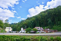
Clinchco, Virginia

Last updated

Clinchco, Virginia
Clinchco-from-Banner-va.jpg
Clinchco
VAMap-doton-Clinchco.PNG
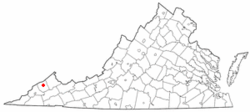
Location of Clinchco, Virginia
Coordinates: 37°9′45″N82°21′36″W / 37.16250°N 82.36000°W / 37.16250; -82.36000
CountryUnited States
State Virginia
County Dickenson
Area
[1]
  Total2.83 sq mi (7.32 km2)
  Land2.79 sq mi (7.23 km2)
  Water0.03 sq mi (0.08 km2)
Elevation
1,398 ft (426 m)
Population
 (2010)
  Total337
  Estimate 
(2019) [2]
294
  Density105.26/sq mi (40.64/km2)
Time zone UTC−5 (Eastern (EST))
  Summer (DST) UTC−4 (EDT)
ZIP code
24226
Area code 276
FIPS code 51-17504 [3]
GNIS feature ID1502782 [4]
Website https://clinchcova.net/

Clinchco is a town in Dickenson County, Virginia, United States. The town, formerly known as Moss, was named for both the Clinchfield Railroad and the Clinchfield Coal Corporation. [5] The population was 337 at the 2010 census, [6] down from 424 at the 2000 census. The Clinchco post office was established in 1917. [7]

Contents

Geography

Clinchco is located in north-central Dickenson County at 37°9′45″N82°21′36″W / 37.16250°N 82.36000°W / 37.16250; -82.36000 (37.162466, 82.359951). [8] The town is situated in the valley of the McClure River, a northeast-flowing tributary of the Russell Fork, part of the Levisa Fork/Big Sandy River system leading north to the Ohio River. Virginia State Routes 63 and 83 run through the center of town. VA 83 leads northeast (downriver) 7 miles (11 km) to Haysi, while VA 63 follows a ridge route that takes 10 miles (16 km) to reach Haysi. The two highways run south (upriver) together 5 miles (8 km) to Fremont. St. Paul is 29 miles (47 km) south of Clinchco via VA 63, and Pound is 20 miles (32 km) west via VA 83.

According to the United States Census Bureau, Clinchco has a total area of 2.84 square miles (7.35 km2), of which 2.80 square miles (7.26 km2) is land and 0.03 square miles (0.08 km2), or 1.15%, is water. [6]

Demographics

Historical population
CensusPop.Note
2000 424
2010 337−20.5%
2019 (est.)294 [2] −12.8%
U.S. Decennial Census [9]

At the 2000 census there were 424 people, 189 households, and 113 families in the town. The population density was 153.8 people per square mile (59.3/km2). There were 226 housing units at an average density of 82.0 per square mile (31.6/km2). The racial makeup of the town was 90.57% White, 8.96% African American, 0.24% from other races, and 0.24% from two or more races. Hispanic or Latino of any race were 1.42%. [3]

Of the 189 households 30.2% had children under the age of 18 living with them, 45.5% were married couples living together, 10.6% had a female householder with no husband present, and 39.7% were non-families. 37.0% of households were one person and 18.0% were one person aged 65 or older. The average household size was 2.24 and the average family size was 3.00.

The age distribution was 23.6% under the age of 18, 7.1% from 18 to 24, 26.9% from 25 to 44, 25.7% from 45 to 64, and 16.7% 65 or older. The median age was 39 years. For every 100 females, there were 86.0 males. For every 100 females age 18 and over, there were 86.2 males.

The median household income was $18,393 and the median family income was $23,750. Males had a median income of $30,313 versus $19,688 for females. The per capita income for the town was $12,257. About 26.0% of families and 30.1% of the population were below the poverty line, including 40.0% of those under age 18 and 23.6% of those age 65 or over.

Notable people

Picture a bunch of mountains all grouped together with narrow, winding roads lacing through them. Clinchco's a little speck by the side of one of those roads, far in the southwest tip of the triangle of Virginia. [10]

Climate

The climate in this area is characterized by relatively high temperatures and evenly distributed precipitation throughout the year. The Köppen Climate System describes the weather as humid subtropical, and uses the abbreviation Cfa. [11]

Related Research Articles

<span class="mw-page-title-main">Russell County, Virginia</span> County in Virginia, United States

Russell County is a county located in the Commonwealth of Virginia. As of the 2020 census, the population was 25,781. Its county seat is Lebanon.

<span class="mw-page-title-main">Dickenson County, Virginia</span> County in Virginia, United States

Dickenson County is a county located in the Commonwealth of Virginia. As of the 2020 census, the population was 14,124. Its county seat is Clintwood.

<span class="mw-page-title-main">Buchanan County, Virginia</span> County in Virginia, United States

Buchanan County is a United States county in far western Virginia, the only county in the state to border both West Virginia and Kentucky. The county is part of the Southwest Virginia region and lies in the rugged Appalachian Plateau portion of the Appalachian Mountains. Its county seat is Grundy.

<span class="mw-page-title-main">Fort Benning South, Georgia</span> CDP in Georgia, United States

Fort Benning South is a former census-designated place (CDP) in Chattahoochee County, Georgia, United States. It is part of the Columbus, Georgia-Alabama Metropolitan Statistical Area. The population was 11,737 at the 2000 census. The area is now part of the consolidated city of Cusseta.

<span class="mw-page-title-main">South Dennis, Massachusetts</span> Census-designated place in Massachusetts, United States

South Dennis is a census-designated place (CDP) in the town of Dennis in Barnstable County, Massachusetts, United States. The population was 3,643 at the 2010 census, the most of the 5 CDPs in Dennis.

<span class="mw-page-title-main">Melfa, Virginia</span> Town in Virginia, United States

Melfa is a town in Accomack County on the Eastern Shore of Virginia in the United States. The population was 408 at the 2010 census.

<span class="mw-page-title-main">Parksley, Virginia</span> Town in Virginia, United States

Parksley is a town in Accomack County, Virginia, United States. The population was 842 at the 2010 census. It is home to the Eastern Shore Railway Museum.

<span class="mw-page-title-main">Clintwood, Virginia</span> Town in Virginia, United States

Clintwood is a town in Dickenson County, Virginia, United States. The population was 1,414 at the 2010 census, with an estimated population of 1,304 in 2018. It is the county seat of Dickenson County.

<span class="mw-page-title-main">Haysi, Virginia</span> Town in Virginia, United States

Haysi is a town in Dickenson County, Virginia, United States. The population was 498 at the 2010 census, up from 186 at the 2000 census, over which time period the town's area tripled.

<span class="mw-page-title-main">Virgilina, Virginia</span> Town in Virginia, United States

Virgilina is a town in Halifax County, Virginia, United States. The population was 154 at the 2010 census. Virgilina was once a copper mining town. It was a stop on the Atlantic and Danville Railway as recently as the 1950s. It is named "Virgilina" because it is located on the Virginia and North Carolina border.

<span class="mw-page-title-main">Cleveland, Virginia</span> Town in Virginia, United States

Cleveland is a town in central Russell County, Virginia, United States. The population was 128 at the 2010 census.

<span class="mw-page-title-main">Lebanon, Virginia</span> Town in Virginia, United States

Lebanon is a town in Russell County, Virginia, United States. The population was 3,424 at the 2010 census. It is the county seat of Russell County.

<span class="mw-page-title-main">Clinchport, Virginia</span> Town in Virginia, United States

Clinchport is a town in Scott County, Virginia. The population was 64 at the 2020 census. Clinchport is the least-populated municipality in Virginia. It is part of the Kingsport-Bristol-Bristol, TN-VA Metropolitan Statistical Area, which is a component of the Johnson City-Kingsport-Bristol, TN-VA Combined Statistical Area – commonly known as the "Tri-Cities" region.

<span class="mw-page-title-main">Duffield, Virginia</span> Town in Virginia, United States

Duffield is a town in Scott County, Virginia, United States. The population was 73 at the 2020 census. It is part of the Kingsport-Bristol-Bristol, TN-VA Metropolitan Statistical Area, which is a component of the Johnson City-Kingsport-Bristol, TN-VA Combined Statistical Area – commonly known as the "Tri-Cities" region.

<span class="mw-page-title-main">Dungannon, Virginia</span> Town in Virginia, United States

Dungannon is a town in Scott County, Virginia. The population was 332 at the 2010 census. It was named after the town of Dungannon in County Tyrone, Northern Ireland.

<span class="mw-page-title-main">Weber City, Virginia</span> Town in Virginia, United States

Weber City is an incorporated town in Scott County, Virginia, United States. The population was 1,327 at the 2010 census. It is part of the Kingsport–Bristol (TN)–Bristol (VA) Metropolitan Statistical Area, which is a component of the Johnson City–Kingsport–Bristol, TN-VA Combined Statistical Area – commonly known as the "Tri-Cities" region.

<span class="mw-page-title-main">Whitesville, West Virginia</span> Town in West Virginia, United States

Whitesville is a town and former coal town in Boone County, West Virginia, United States, along the Big Coal River. The population was 361 at the 2020 census. Whitesville was incorporated on August 15, 1935 by the Boone County Circuit Court. The town derives its name from B. W. White, a pioneer settler. Whitesville was formerly known as Jarrold's Valley and Pritchard City.

<span class="mw-page-title-main">Rainelle, West Virginia</span> Town in West Virginia, United States

Rainelle is a town on the western edge of Greenbrier County, West Virginia, United States. It sits at the base of Sewell Mountain and Sims Mountain, and is bisected by the Meadow River. The only means of transportation to and from Rainelle are roads; primarily US 60 and WV 20, which merge on the western end of the town, and the James River and Kanawha Turnpike, which enters from the south. The population was 1,190 at the 2020 census.

<span class="mw-page-title-main">West Hamlin, West Virginia</span> Town in West Virginia, United States

West Hamlin is a town in Lincoln County, West Virginia, United States, along the Guyandotte River. The population was 519 at the 2020 census, and is now down to 509, according to the 2021 census. West Hamlin is a part of the Huntington-Ashland, WV-KY-OH, Metropolitan Statistical Area (MSA). West Hamlin is west of the county seat at Hamlin, hence the name.

<span class="mw-page-title-main">Matoaka, West Virginia</span> Census-designated place in West Virginia, United States

Matoaka is a census-designated place in Mercer County, West Virginia, United States. The population was 227 at the 2010 census. It is part of the Bluefield, WV-VA micropolitan area which has a population of 107,578. This town is named for Chief Powhatan's daughter Matoaka who was better known by her nickname "Pocahontas". Matoaka became an unincorporated town when it voted to dissolve its charter in May 2018.

References

  1. "2019 U.S. Gazetteer Files". United States Census Bureau. Retrieved August 7, 2020.
  2. 1 2 "Population and Housing Unit Estimates". United States Census Bureau. May 24, 2020. Retrieved May 27, 2020.
  3. 1 2 "U.S. Census website". United States Census Bureau . Retrieved January 31, 2008.
  4. "US Board on Geographic Names". United States Geological Survey. October 25, 2007. Retrieved January 31, 2008.
  5. Hanson, Raus McDill (1969). Virginia Place Names: Derivations, Historical Uses. McClure Press.
  6. 1 2 "Geographic Identifiers: 2010 Demographic Profile Data (G001): Clinchco town, Virginia". American Factfinder. U.S. Census Bureau. Archived from the original on February 13, 2020. Retrieved January 13, 2016.
  7. "Dickenson County". Jim Forte Postal History. Archived from the original on March 4, 2016. Retrieved September 29, 2014.
  8. "US Gazetteer files: 2010, 2000, and 1990". United States Census Bureau. February 12, 2011. Retrieved April 23, 2011.
  9. "Census of Population and Housing". Census.gov. Retrieved June 4, 2015.
  10. Brotherton, Marcus (2011). Shifty's War: The Authorized Biography of Sergeant Darrell "Shifty" Powers, the Legendary Sharpshooter from the Band of Brothers. New York: Penguin. ISBN   9780425240977.
  11. Climate Summary for Clinchco, Virginia