Dickenson County is a county located in the Commonwealth of Virginia. As of the 2020 census, the population was 14,124. Its county seat is Clintwood.

Buchanan County is a United States county in far western Virginia, the only Virginia county to border both West Virginia and Kentucky. The county is part of the Southwest Virginia region and lies in the rugged Appalachian Plateau portion of the Appalachian Mountains. Its county seat is Grundy.

Clinchco is a town in Dickenson County, Virginia, United States. The town, formerly known as Moss, was named for both the Clinchfield Railroad and the Clinchfield Coal Corporation. The population was 337 at the 2010 census, down from 424 at the 2000 census. The Clinchco post office was established in 1917.

Haysi is a town in Dickenson County, Virginia, United States. The population was 498 at the 2010 census, up from 186 at the 2000 census, over which time period the town's area tripled.
U.S. Route 15 is a part of the U.S. Highway System that runs from Walterboro, South Carolina to Painted Post, New York. In Virginia, the U.S. Highway runs 230.37 miles (370.74 km) from the North Carolina state line near Clarksville north to the Maryland state line at the Potomac River near Lucketts. US 15 is a major north–south highway through the Piedmont of Virginia, connecting Clarksville and Farmville in Southside Virginia with Culpeper, Warrenton, and Leesburg in Northern Virginia.

U.S. Route 421 (US 421) is a part of the U.S. Highway System that runs from Fort Fisher, North Carolina to Michigan City, Indiana. In Virginia, the U.S. Highway runs 69.23 miles (111.41 km) from the Tennessee state line between the twin cities of Bristol, Tennessee and Bristol, Virginia north and west to the Kentucky state line near St. Charles. Between its endpoints, US 421 has lengthy concurrencies with US 23 and US 58 during its course through Bristol, Weber City, Gate City, Duffield, and Pennington Gap in Southwest Virginia.

State Route 72 is a primary state highway in the southwest part of the U.S. state of Virginia. It runs from SR 71 in Gate City north to SR 65 at Fort Blackmore, northeast with SR 65 to Dungannon, and north via Coeburn to SR 83 near Clintwood.

State Route 67 is a primary state highway in the southwest part of the U.S. state of Virginia. It runs from SR 80 near Honaker east to U.S. Route 460 at Raven, east concurrently with US 460 and US 460 Business into downtown Richlands, and north to SR 616 at Jewell Ridge on the Tazewell–Buchanan county line.
U.S. Route 460 (US 460) in Virginia runs west-east through the southern part of the Commonwealth. The road has two separate pieces in Virginia, joined by a relatively short section in West Virginia. Most of US 460 is a four-lane divided highway and is a major artery in the southern third of the state. From Petersburg to Suffolk, US 460 is a four-lane non-divided highway. It is a popular alternative to Interstate 64 (I-64) when going from Richmond and other points in central Virginia to the Currituck Sound and Outer Banks of North Carolina, avoiding the congestion and tunnels of the more northerly I-64 corridor. The road passes through several small towns that built up at stops along the railroad line.

State Route 80 is a primary state highway in the southwest part of the U.S. state of Virginia. It runs from the Kentucky state line at Breaks Interstate Park east to U.S. Route 11 near Meadowview. Kentucky Route 80 and Missouri's Route 80 continue the number west to Matthews, Missouri. The entire length of SR 80 is part of U.S. Bicycle Route 76.
U.S. Route 19 is a part of the U.S. Highway System that runs from Memphis, Florida to Erie, Pennsylvania. In Virginia, the highway runs 88.89 miles (143.05 km) between two pairs of twin cities: Bristol, Tennessee and Bristol, Virginia, at the Virginia–Tennessee state line, and Bluefield, Virginia and Bluefield, West Virginia, at the Virginia–West Virginia state line. Between its endpoints, US 19 has lengthy concurrencies with US 11, US 58 Alternate, and US 460 during its course connecting Abingdon, Lebanon, and Tazewell within Washington, Russell, and Tazewell counties in Southwest Virginia.

Virginia State Route 9 is a primary state highway in the U.S. state of Virginia. Known as Charles Town Pike, the state highway runs 13.08 miles (21.05 km) from the West Virginia state line near Mechanicsville, where the highway continues west as West Virginia Route 9, east to SR 7 and SR 7 Business in Paeonian Springs. SR 9 is the main east–west highway of northwestern Loudoun County, connecting Leesburg with Hillsboro and the West Virginia cities of Charles Town and Martinsburg. As a result, the state highway and its West Virginia continuation are a major, overburdened commuter route between the Eastern Panhandle of West Virginia and Washington, D.C.

State Route 63 is a primary state highway in the U.S. state of Virginia. The state highway runs 39.28 miles (63.22 km) from U.S. Route 58 Alternate in St. Paul north to SR 80 and SR 83 in Haysi.
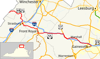
State Route 55 is a primary state highway in the U.S. state of Virginia. Known for most of its length as John Marshall Highway, the state highway runs 64.71 miles (104.14 km) from the West Virginia state line, where the highway continues as West Virginia Route 55, east to U.S. Route 29 in Gainesville. West of its interchange with Interstate 81 (I-81) in Strasburg, SR 55 runs concurrently with the easternmost portion of US 48 as part of Corridor H. East of Front Royal, the state highway serves as the local complement of I-66 as it passes through the towns of Marshall, The Plains, and Haymarket.

State Route 24 is a primary state highway in the U.S. state of Virginia. The state highway runs 89.57 miles (144.15 km) from U.S. Route 221 and SR 116 in Roanoke east to US 60 in Mt. Rush. SR 24 connects Roanoke with several small communities in southern Bedford County and central Campbell County. The state highway also runs concurrently with US 460 west of Appomattox and passes through Appomattox Court House National Historical Park, which is the site of Robert E. Lee's final stand and surrender in the American Civil War.

State Route 43 is a primary state highway in the U.S. state of Virginia. The state highway consists of two disjoint segments that have a total length of 61.20 miles (98.49 km). The southern portion of the state highway runs 39.79 miles (64.04 km) from U.S. Route 29 Business in Altavista north to the Blue Ridge Parkway at Peaks of Otter. The northern segment has a length of 21.41 miles (34.46 km) between the Blue Ridge Parkway near Buchanan and US 220 in Eagle Rock. The two sections of SR 43 are connected by 4.9 miles (7.9 km) of the Blue Ridge Parkway. The southern portion of the state highway connects Altavista with Bedford and Peaks of Otter. The northern section of SR 43 follows the James River through a narrow valley between Buchanan and Eagle Rock.

Virginia State Route 130 is a primary state highway in the U.S. state of Virginia. The state highway runs 34.69 miles (55.83 km) from U.S. Route 11 at Natural Bridge east to SR 669 and SR 670 east of US 29 near Madison Heights. SR 130 runs concurrently with US 501 from Glasgow through the James River gorge through the Blue Ridge Mountains, connecting eastern Rockbridge County with western and southern Amherst County near Lynchburg.

State Route 122 is a primary state highway in the U.S. state of Virginia. The state highway runs 54.58 miles (87.84 km) from SR 40 in Rocky Mount north to U.S. Route 501 in Big Island. SR 122 passes through the Blue Ridge foothills of Franklin and Bedford counties, connecting Rocky Mount with the town of Bedford. The state highway provides access to Booker T. Washington National Monument and Smith Mountain Lake, and the National D-Day Memorial via its Bedford business route.

State Route 151 is a primary state highway in the U.S. state of Virginia. The state highway runs 35.22 miles (56.68 km) from U.S. Route 29 at Buffalo Hill north to US 250 at Critzers Shop. SR 151 traverses the Blue Ridge foothills of western Nelson County, where the highway provides access to the Wintergreen Resort.

State Route 218 is a primary state highway in the U.S. state of Virginia. The state highway runs 30.00 miles (48.28 km) from U.S. Route 1 and US 17 Business in Falmouth east to SR 205 in Tetotum. SR 218 connects suburban communities in Stafford County east of Fredericksburg with rural areas in northern and eastern King George County.


