Virginia State Route 72

Last updated

Virginia 72.svg

State Route 72
VA 72 map.svg
Route information
Maintained by VDOT
Length49.19 mi [1] [2] [3] (79.16 km)
ExistedJuly 1, 1933 [4] –present
Tourist
routes
Virginia D6-V1.svg Virginia Byway
Major junctions
South endVirginia 71.svg SR 71 in Gate City
 Virginia 65.svg SR 65 in Dungannon
Alt plate.svg
US 58.svg US 58 Alt. in Coeburn
North endVirginia 83.svg SR 83 near Clintwood
Location
Counties Scott, Wise, Dickenson
Highway system
Virginia 71.svg SR 71 SR 73 Virginia 73.svg

State Route 72 (SR 72) is a primary state highway in the southwest part of the U.S. state of Virginia. It runs from SR 71 in Gate City north to SR 65 at Fort Blackmore, northeast with SR 65 to Dungannon, and north via Coeburn to SR 83 near Clintwood.

Contents

Route description

View north at the south end of SR 72 at SR 71 in Gate City 2017-06-12 17 30 38 View north along Virginia State Route 72 (Veterans Memorial Highway) at Virginia State Route 71 (Nickelsville Highway) in Gate City, Scott County, Virginia.jpg
View north at the south end of SR 72 at SR 71 in Gate City

SR 72 begins at SR 71 in Slabtown, east of downtown Gate City. The intersection of the two routes lies on the town limits of Gate City. It heads north across the Moccasin Ridge via some small creek valleys and crosses Copper Creek at Williams Mill. SR 72 continues north across Copper Ridge and into the Clinch River valley, where it meets SR 65. SR 65 and SR 72 overlap, paralleling the Clinch River to Dungannon. After the two routes split, SR 72 continues to follow the river to the northeast, but then splits in order to cross Stone Mountain. [5]

The land flattens out near the ScottWise county line, and SR 72 continues northwest and north across the Guest River and past Maytown to an interchange with U.S. Route 58 Alternate within the town limits of Coeburn. Signage in Coeburn directs through traffic on SR 72 to use US 58 Alt. to Front and Second Streets west of downtown Coeburn rather than using the official route on Front Street. Just 0.1 miles (0.16 km) past the interchange, SR 72 reaches SR 158 at a signalized intersection. SR 72 turns west with SR 158, formerly US 58 Alt. until a bypass around Coeburn was built, and then splits to the north. It runs alongside small creeks, passing Bondtown and Cranes Nest on its way to Fuller Gap, where it crosses Guest Mountain and the Tennessee Valley Divide. It then descends through small creek valleys and alongside the Cranes Nest River to the Dickenson County line. [5]

SR 72 continues along the Cranes Nest River, but splits to cross a small ridge at Hibbitts Gap. Then it continues northerly alongside small creeks, past Darwin to its end at SR 83 at Georges Fork, west of Clintwood. [5]

History

The road from Coeburn north to Clintwood was part of the original state highway system designated in 1918, as a spur of SR 11 (now US 58 Alt.). [6] In the 1923 renumbering it became part of SR 114, which continued east from Clintwood to Haysi. The piece south of Clintwood was renumbered SR 122 in the 1928 renumbering, and that same year it was extended south from Clintwood to Dungannon and southeast to end at SR 107 (now SR 71). [7] SR 122 was renumbered SR 72 in the 1933 renumbering. In 1949, the section south of Dungannon was transferred to the secondary system as SR 774, due to its "local character and very low traffic volume" of 187 per day. [8] (SR 774 now carries about 360 vehicles per day. [1] ) SR 72 was extended in 1986, running southwest on SR 65 to Fort Blackmore and then south to SR 71 in Gate City, taking over parts of SR 619, SR 676, SR 661, SR 710, and SR 660. [9]

Major intersections

CountyLocationmi [10] kmDestinationsNotes
Scott Gate City 0.000.00Virginia 71.svg SR 71 (Nickelsville Highway / East Jackson Street) Nickelsville, Gate City
Fort Blackmore 10.7817.35Virginia 65.svgCircle sign 619.svg SR 65 south (Clinch River Highway) / SR 619 (Old Route 72) Clinchport Southern end of SR 65 concurrency
Dungannon 19.1730.85Virginia 65.svg SR 65 north (Sinking Creek Highway) St. Paul, Gate City Northern end of SR 65 concurrency
Wise Coeburn 30.5949.23Alt plate.svg
US 58.svg US 58 Alt.  Norton
Interchange; exit 2 (US 58 Alt.)
30.7849.54Virginia 158.svg SR 158 east (Front Street)Southern end of SR 158 concurrency
31.4350.58Virginia 158.svg SR 158 west (Front Street)Northern end of SR 158 concurrency
Dickenson Georges Fork 49.1979.16Virginia 83.svg SR 83 (Dickenson Highway) Pound, Clintwood, Breaks Interstate Park
1.000 mi = 1.609 km; 1.000 km = 0.621 mi

Related Research Articles

Virginia State Route 5 State highway in Virginia, United States

State Route 5 runs between the independent cities of Richmond and Williamsburg in the U.S. state of Virginia. Between Charles City County and James City County, it crosses the Chickahominy River via the Judith Stewart Dresser Bridge, a fixed-span bridge which replaced historic Barrett's Ferry and the former drawbridge.

Virginia State Route 31 Primary state highway in the U.S

State Route 31 is a primary state highway in the U.S. state of Virginia. The state highway runs 24.56 miles (39.53 km) from U.S. Route 460 in Wakefield north to SR 5 and SR 199 in Williamsburg. SR 31 is the primary north–south highway of Surry County, where the highway serves the towns of Surry and Dendron. The state highway also connects Williamsburg with Jamestown. The sections of SR 31 on either side of the James River are connected by the Jamestown Ferry.

Virginia State Route 114

State Route 114 is a primary state highway in the U.S. state of Virginia. Known as Peppers Ferry Road, the state highway runs 10.32 miles (16.61 km) from U.S. Route 11 in Fairlawn east to US 460 in Christiansburg. SR 114 is the northernmost of three east–west highways between Radford and Christiansburg and the most direct highway between Radford and Blacksburg. The state highway also connects those cities with the Radford Army Ammunition Plant.

Virginia State Route 70

State Route 70 is a primary state highway in Lee County, Virginia, running from the Tennessee state line to U.S. Route 58 in Jonesville. Its continuation in Tennessee, also numbered State Route 70, continues south to the North Carolina state line at North Carolina Highway 208.

Virginia State Route 71

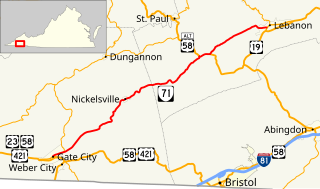
State Route 71 is a primary state highway in the southwest part of the U.S. state of Virginia. It runs from Gate City northeast to Lebanon, mostly through river valleys. Despite running more east–west than north–south, it is signed north–south; it parallels the similarly-oriented U.S. Route 11 and Interstate 81.

U.S. Route 23 in Virginia

U.S. Route 23 is a part of the U.S. Highway System that runs from Jacksonville, Florida to Mackinaw City, Michigan. In Virginia, the U.S. Highway runs 60.80 miles (97.85 km) from the Tennessee state line near Weber City north to the Kentucky state line near Pound. US 23, which is known as Orby Cantrell Highway for most of its course, is a four-lane divided highway that follows Corridor B of the Appalachian Development Highway System through Southwest Virginia. The U.S. Highway serves as the main east–west highway of Scott County and the primary north–south highway of Wise County. US 23 runs concurrently with US 58 from Weber City to Duffield and with US 58 Alternate between Big Stone Gap and the independent city of Norton.

Virginia State Route 75

State Route 75 is a primary state highway in the southwest part of the U.S. state of Virginia, running southwest from U.S. Route 11 and U.S. Route 58 Alternate in Abingdon to Tennessee's State Route 44.

Virginia State Route 67

State Route 67 is a primary state highway in the southwest part of the U.S. state of Virginia. It runs from State Route 80 near Honaker east to U.S. Route 460 at Raven, east concurrently with US 460 and U.S. Route 460 Business into downtown Richlands, and north to State Route 616 at Jewell Ridge on the Tazewell–Buchanan county line.

Virginia State Route 16

State Route 16 is a primary state highway in the southwest part of the U.S. state of Virginia. It runs from the North Carolina border at North Carolina Highway 16 north to the West Virginia border at West Virginia Route 16, passing through the towns of Troutdale, Marion, and Tazewell. Highway 16 is part of a three-state route 16 that connects the Charlotte region with northwestern West Virginia.

Virginia State Route 80

State Route 80 is a primary state highway in the southwest part of the U.S. state of Virginia. It runs from the Kentucky state line at Breaks Interstate Park east to U.S. Route 11 near Meadowview. Kentucky Route 80 and Missouri's Route 80 continue the number west to Matthews, Missouri.

Virginia State Route 83

State Route 83 is a primary state highway in the U.S. state of Virginia. The state highway runs 61.71 miles (99.31 km) from U.S. Route 23 Business in Pound east to the West Virginia state line in Paynesville, where the highway continues as West Virginia Route 83. SR 83 is the main highway of Dickenson County, where it connects the county's three towns of Clintwood, Clinchco, and Haysi. The state highway connects those towns with Pound in Wise County and Grundy in Buchanan County, and connects Grundy with McDowell County, West Virginia.

Virginia State Route 65

State Route 65, formerly State Route 66, is a primary state highway in the U.S. state of Virginia. The state highway runs 34.06 miles (54.81 km) from U.S. Route 23, US 58, and US 421 in Clinchport north to US 58 Alternate in Castlewood.

Virginia State Route 99

State Route 99 is a primary state highway in the U.S. state of Virginia. The state highway runs 5.20 miles (8.37 km) from the north town limit of Pulaski east to SR F-047 just east of Interstate 81 (I-81) and SR 100 at McAdam.

Virginia State Route 8 State highway in Virginia, United States

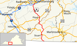
State Route 8 is a primary state highway in the U.S. state of Virginia. The state highway runs 55.88 miles (89.93 km) from the North Carolina state line near Palmetto, where the highway continues south as North Carolina Highway 8, north to U.S. Route 11 in Christiansburg. SR 8 is part of a 151-mile (243 km) two-state highway 8 system and is the main north–south highway of Patrick County, Floyd County, and southern Montgomery County, connecting their respective county seats of Stuart, Floyd, and Christiansburg with each other and with the Blue Ridge Parkway. The state highway also links the New River Valley region of Virginia with Southside Virginia via US 58 and the Piedmont Triad of North Carolina via NC 8.

Virginia State Route 41

State Route 41 is a primary state highway in the U.S. state of Virginia. Known as Franklin Turnpike, the state highway runs 22.5 miles (36.2 km) from SR 360 northeast of Danville to SR 57 in Callands. The Virginia Department of Transportation (VDOT) officially designates the route north of U.S. Route 29 Bus. in Danville as a part of SR 41 but the Franklin Turnpike south and east of this point is signed as SR 41.

Virginia State Route 144

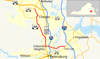
State Route 144 is a primary state highway in the U.S. state of Virginia. The state highway runs 13.97 miles (22.48 km) from SR 36 at Fort Lee north to SR 145 at Centralia. SR 144's east–west segment is the main highway between Colonial Heights and both Fort Lee and Hopewell. The state highway's north–south section connects U.S. Route 1 and US 301 in Colonial Heights with SR 10 in Chester. It was first added to the state highway system in 1930 as State Route 425 and had gained its current routing and designation by 1987.

References

  1. 1 2 "2005 Virginia Department of Transportation Jurisdiction Report - Daily Traffic Volume Estimates - Scott County" (PDF). (269 KB)
  2. "2005 Virginia Department of Transportation Jurisdiction Report - Daily Traffic Volume Estimates - Wise County" (PDF). (247 KB)
  3. "2005 Virginia Department of Transportation Jurisdiction Report - Daily Traffic Volume Estimates - Dickenson County" (PDF). (146 KB)
  4. "New Numbers of Va. Highways Effective July 1". The Richmond Times-Dispatch. May 10, 1933. p. 5. Retrieved January 21, 2020 via Newspapers.com. Open Access logo PLoS transparent.svg
  5. 1 2 3 Google (August 6, 2014). "Virginia State Route 72" (Map). Google Maps . Google. Retrieved August 6, 2014.
  6. State Highway Commission of Virginia (July 5, 1922). Minutes of the First Meeting of the State Highway Commission Created Under the Acts of 1922 (PDF) (Report). Richmond, VA: Commonwealth of Virginia., Proposed "State Highway System" for Virginia, as Recommended by the State Roads Committee, January, 1918
  7. State Highway Commission of Virginia (August 9–10, 1928). Minutes of Meeting (PDF) (Report). Richmond, VA: Commonwealth of Virginia. pp. 12–13.
  8. State Highway Commission of Virginia (April 19–20, 1949). Minutes of Meeting (PDF) (Report). Roanoke and Richmond, VA: Commonwealth of Virginia. p. 3.
  9. State Highway and Transportation Board (May 15, 1986). Minutes of Meeting (PDF) (Report). Richmond, VA: Commonwealth of Virginia. p. 2.
  10. "VDOT Annual Average Daily Traffic (AADT)" (Shapefile). Virginia Department of Transportation. 2012. Retrieved May 17, 2014.

Route map:

KML file (edithelp)
    KML is from Wikidata
    <  SR 121 District 1 State Routes
    1928–1933
    SR 123  >