Dickenson County, Virginia

Last updated

Dickenson County
Dickenson County Courthouse.jpg
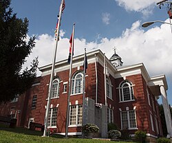
Dickenson County Courthouse in Clintwood
DickensonSeal.jpg
Map of Virginia highlighting Dickenson County.svg
Location within the U.S. state of Virginia
Virginia in United States.svg
Virginia's location within the U.S.
Coordinates: 37°07′N82°21′W / 37.12°N 82.35°W / 37.12; -82.35
CountryFlag of the United States.svg United States
StateFlag of Virginia.svg  Virginia
Founded1880
Named for William J. Dickinson
Seat Clintwood
Largest townClintwood
Area
  Total334 sq mi (870 km2)
  Land331 sq mi (860 km2)
  Water3.1 sq mi (8 km2)  0.9%
Population
 (2020)
  Total14,124
  Density42/sq mi (16/km2)
Time zone UTC−5 (Eastern)
  Summer (DST) UTC−4 (EDT)
Congressional district 9th
Website www.dickensonva.org

Dickenson County is a county located in the Commonwealth of Virginia. As of the 2020 census, the population was 14,124. [1] Its county seat is Clintwood. [2]

Contents

History

Dickenson County, formed in 1880 from parts of Buchanan County, Russell County, and Wise County, is Virginia's youngest county. It was named for William J. Dickenson, [3] delegate to the Virginia General Assembly from Russell County, 1859–1861, 1865–1867, and 1877–1882. This formation came as a result of demands from the inhabitants that they be represented by a county government closer to the people. In 1880, Delegate Dickenson sponsored the bill in the House of Delegates to establish Dickenson County as the one-hundredth county in Virginia. Dickenson County has since become known as "Virginia's Baby."

Geography

According to the U.S. Census Bureau, the county has a total area of 334 square miles (870 km2), of which 331 square miles (860 km2) is land and 3.1 square miles (8.0 km2) (0.9%) is water. [4]

Districts

The county is divided into five magisterial districts with a supervisor elected from each district every four years. The districts are: Clintwood, Ervinton, Sandlick, Kenady, and Willis.

Adjacent counties

National protected area

Major highways

Demographics

Historical population
CensusPop.Note
1890 5,077
1900 7,74752.6%
1910 9,19918.7%
1920 13,54247.2%
1930 16,16319.4%
1940 21,26631.6%
1950 23,39310.0%
1960 20,211−13.6%
1970 16,077−20.5%
1980 19,80623.2%
1990 17,620−11.0%
2000 16,395−7.0%
2010 15,903−3.0%
2020 14,124−11.2%
2023 (est.)13,640 [5] −3.4%
U.S. Decennial Census [6]
1790–1960 [7] 1900–1990 [8]
1990–2000 [9] 2010 [10] 2020 [11]

2020 census

Dickenson County, Virginia – Racial and ethnic composition
Note: the US Census treats Hispanic/Latino as an ethnic category. This table excludes Latinos from the racial categories and assigns them to a separate category. Hispanics/Latinos may be of any race.
Race / Ethnicity (NH = Non-Hispanic)Pop 2010 [10] Pop 2020 [11] % 2010% 2020
White alone (NH)15,65013,69198.41%96.93%
Black or African American alone (NH)51480.32%0.34%
Native American or Alaska Native alone (NH)23220.14%0.16%
Asian alone (NH)17120.11%0.08%
Pacific Islander alone (NH)020.00%0.01%
Some Other Race alone (NH)9120.06%0.08%
Mixed Race or Multi-Racial (NH)672540.42%1.80%
Hispanic or Latino (any race)86830.54%0.59%
Total15,90314,124100.00%100.00%

2000 census

As of the census [12] of 2000, there were 16,395 people, 6,732 households, and 4,887 families residing in the county. The population density was 49 people per square mile (19 people/km2). There were 7,684 housing units at an average density of 23 units per square mile (8.9 units/km2). The racial makeup of the county was 98.96% White, 0.35% Black or African American, 0.12% Native American, 0.07% Asian, 0.05% from other races, and 0.45% from two or more races. 0.43% of the population were Hispanic or Latino of any race.

There were 6,732 households, out of which 30.40% had children under the age of 18 living with them, 58.00% were married couples living together, 10.60% had a female householder with no husband present, and 27.40% were non-families. 25.30% of all households were made up of individuals, and 11.30% had someone living alone who was 65 years of age or older. The average household size was 2.42 and the average family size was 2.88.

In the county, the population was spread out, with 22.10% under the age of 18, 8.90% from 18 to 24, 27.60% from 25 to 44, 26.90% from 45 to 64, and 14.50% who were 65 years of age or older. The median age was 40 years. For every 100 females there were 95.70 males. For every 100 females age 18 and over, there were 93.60 males.

The median income for a household in the county was $23,431, and the median income for a family was $27,986. Males had a median income of $27,281 versus $17,695 for females. The per capita income for the county was $12,822. About 16.90% of families and 21.30% of the population were below the poverty line, including 26.80% of those under age 18 and 17.30% of those age 65 or over.

Education

Public high schools

Public middle schools

Public elementary schools

Media

Radio station

Law enforcement

Dickenson County Sheriff's Office
AbbreviationDCSO
Agency overview
Formed1880
Jurisdictional structure
Constituting instrument
  • Yes
General nature
Operational structure
Headquarters Clintwood, Virginia
Deputies35
Civilians15
Agency executive
Website
Official Website

The Dickenson County Sheriff's Office (DCSO) is the primary law enforcement agency in Dickenson County, Virginia. When the office was formed in 1880, one person was appointed as the Election Supervisor, Tax Collector, and the Chief Law Enforcement Officer. Now the sheriff is an elected official. [13]

Politics

United States presidential election results for Dickenson County, Virginia [14]
Year Republican Democratic Third party
No.%No.%No.%
2020 5,74878.71%1,50320.58%520.71%
2016 4,93276.58%1,33520.73%1732.69%
2012 4,27461.91%2,47335.82%1572.27%
2008 3,32449.22%3,27848.54%1512.24%
2004 3,59148.49%3,76150.78%540.73%
2000 3,12243.21%3,95154.68%1532.12%
1996 2,22932.45%3,91356.97%72610.57%
1992 2,57431.61%4,83959.43%7308.96%
1988 3,09140.65%4,46158.67%520.68%
1984 3,92144.34%4,84854.82%750.85%
1980 3,68746.12%4,17752.25%1311.64%
1976 3,47142.28%4,58355.83%1551.89%
1972 3,63356.22%2,71141.95%1181.83%
1968 3,41246.01%3,35545.25%6488.74%
1964 2,14338.00%3,48561.80%110.20%
1960 2,20344.42%2,75655.56%10.02%
1956 3,44448.15%3,69551.66%140.20%
1952 2,91347.41%3,21052.25%210.34%
1948 2,19742.48%2,94556.94%300.58%
1944 1,76238.69%2,78661.18%60.13%
1940 1,78541.10%2,55158.74%70.16%
1936 1,14629.92%2,68370.05%10.03%
1932 1,22831.67%2,63567.95%150.39%
1928 1,86849.85%1,87950.15%00.00%
1924 1,29442.47%1,61853.10%1354.43%
1920 1,06753.62%90345.38%201.01%
1916 75352.62%65045.42%281.96%
1912 39836.55%52948.58%16214.88%

Communities

Towns

Census-designated place

Other unincorporated communities

Notable people

See also

Related Research Articles

<span class="mw-page-title-main">Wythe County, Virginia</span> County in Virginia, United States

Wythe County is a county located in the southwestern part of the U.S. state of Virginia. As of the 2020 census, the population was 28,290. Its county seat is Wytheville.

<span class="mw-page-title-main">Washington County, Virginia</span> County in Virginia, United States

Washington County is a county located in the Commonwealth of Virginia. As of the 2020 census, the population was 53,935. Its county seat is Abingdon.

<span class="mw-page-title-main">Smyth County, Virginia</span> County in Virginia, United States

Smyth County is a county located in the U.S. state of Virginia. As of the 2020 census, the population was 29,800. Its county seat is Marion.

<span class="mw-page-title-main">Scott County, Virginia</span> County in Virginia, United States

Scott County is a county located in the far southwestern part of the U.S. state of Virginia, on the border with Tennessee. As of the 2020 census, the population was 21,576. Its county seat is Gate City. Scott County was formed by an act of the General Assembly on November 24, 1814, from parts of Washington, Lee, and Russell counties and was named for Virginia -born General Winfield Scott. Scott County is part of the Kingsport–Bristol–Bristol, TN-VA Metropolitan Statistical Area, which is a component of the Johnson City–Kingsport–Bristol, TN-VA Combined Statistical Area, commonly known as the "Tri-Cities" region. The County Administrator is Freda Russell Starnes.

<span class="mw-page-title-main">Russell County, Virginia</span> County in Virginia, United States

Russell County is a county located in the Commonwealth of Virginia. As of the 2020 census, the population was 25,781. Its county seat is Lebanon.

<span class="mw-page-title-main">Richmond County, Virginia</span> County in Virginia, United States

Richmond County is a county located on the Northern Neck in the U.S. state of Virginia. As of the 2020 census, the population sits at 8,923. Its county seat is Warsaw. The rural county should not be confused with the large city and state capital Richmond, Virginia. It was formed in 1692 when the first Rappahannock County was divided to form Richmond County and Essex County.

<span class="mw-page-title-main">Pulaski County, Virginia</span> County in Virginia, United States

Pulaski County is a county located in the southwestern part of the U.S. state of Virginia. As of the 2020 census, the population was 33,800. Its county seat is Pulaski. Pulaski County is part of the Blacksburg–Christiansburg, VA Metropolitan Statistical Area.

<span class="mw-page-title-main">Nottoway County, Virginia</span> County in Virginia, United States

Nottoway County is a county located in the Commonwealth of Virginia. As of the 2020 census, the population was 15,642. Its county seat is Nottoway. It is situated south of the James River, thus making it a part of the Southside Virginia Region.

<span class="mw-page-title-main">Lee County, Virginia</span> County in Virginia, United States

Lee County is the westernmost county in the U.S. Commonwealth of Virginia. As of the 2020 census, the population was 22,173. Its county seat is Jonesville.

<span class="mw-page-title-main">Lancaster County, Virginia</span> County in Virginia, United States

Lancaster County is a county located on the Northern Neck in the Commonwealth of Virginia. As of the 2020 census, the population sits at 10,919. Its county seat is Lancaster.

<span class="mw-page-title-main">Halifax County, Virginia</span> County in Virginia, United States

Halifax County is a county located in the Commonwealth of Virginia. As of the 2020 census, the population was 34,022. Its county seat is Halifax.

<span class="mw-page-title-main">Giles County, Virginia</span> County in Virginia, United States

Giles County is a county located in the U.S. state of Virginia on the West Virginia state line. As of the 2020 census, the population was 16,787. Its county seat is Pearisburg.

<span class="mw-page-title-main">Clarke County, Virginia</span> County in Virginia, United States

Clarke County is a county in the Commonwealth of Virginia. As of the 2020 census, the population was 14,783. Its county seat is Berryville. Clarke County is included in the Washington-Arlington-Alexandria, DC-VA-MD-WV Metropolitan Statistical Area.

<span class="mw-page-title-main">Buchanan County, Virginia</span> County in Virginia, United States

Buchanan County is a United States county in far western Virginia, the only county in the state to border both West Virginia and Kentucky. The county is part of the Southwest Virginia region and lies in the rugged Appalachian Plateau portion of the Appalachian Mountains. Its county seat is Grundy.

<span class="mw-page-title-main">Appomattox County, Virginia</span> County in Virginia, United States

Appomattox County is a United States county located in the Piedmont region and near the center of the Commonwealth of Virginia. The county is part of the Lynchburg, VA Metropolitan Statistical Area, and its county seat is the town of Appomattox.

<span class="mw-page-title-main">Clintwood, Virginia</span> Town in Virginia, United States

Clintwood is a town in Dickenson County, Virginia, United States. The population was 1,377 at the 2020 census. It is the county seat of Dickenson County.

<span class="mw-page-title-main">Haysi, Virginia</span> Town in Virginia, United States

Haysi is a town in Dickenson County, Virginia, United States. The population was 498 at the 2010 census, up from 186 at the 2000 census, over which time period the town's area tripled.

<span class="mw-page-title-main">Yorkshire, Virginia</span> CDP in Virginia, United States

Yorkshire is a census-designated place (CDP) in Prince William County, Virginia, United States. It is an annex of Manassas, Virginia. The population was 6,732 at the 2000 census.

<span class="mw-page-title-main">Tazewell County, Virginia</span> County in Virginia, United States

Tazewell County is a county located in the southwestern portion of the U.S. state of Virginia. As of the 2020 census, the population was 40,429. Its county seat is Tazewell.

<span class="mw-page-title-main">King William County, Virginia</span> County in Virginia, United States

King William County is a county located in the U.S. state of Virginia. As of the 2020 census, the population was 17,810. Its county seat is King William.

References

  1. "Dickenson County, Virginia". United States Census Bureau . Retrieved January 30, 2022.
  2. "Find a County". National Association of Counties. Archived from the original on May 31, 2011. Retrieved June 7, 2011.
  3. Gannett, Henry (1905). The Origin of Certain Place Names in the United States. Govt. Print. Off. pp.  106.
  4. "US Gazetteer files: 2010, 2000, and 1990". United States Census Bureau. February 12, 2011. Retrieved April 23, 2011.
  5. "QuickFacts". United States Census Bureau. Retrieved July 18, 2024.
  6. "Census of Population and Housing from 1790-2000". US Census Bureau . Retrieved January 24, 2022.
  7. "Historical Census Browser". University of Virginia Library. Retrieved January 2, 2014.
  8. "Population of Counties by Decennial Census: 1900 to 1990". United States Census Bureau. Retrieved January 2, 2014.
  9. "Census 2000 PHC-T-4. Ranking Tables for Counties: 1990 and 2000" (PDF). United States Census Bureau. Archived (PDF) from the original on October 9, 2022. Retrieved January 2, 2014.
  10. 1 2 "P2 Hispanic or Latino, and Not Hispanic or Latino by Race – 2010: DEC Redistricting Data (PL 94-171) - Dickenson County, Virginia". United States Census Bureau .
  11. 1 2 "P2 Hispanic or Latino, and Not Hispanic or Latino by Race – 2020: DEC Redistricting Data (PL 94-171) - Dickenson County, Virginia". United States Census Bureau .
  12. "U.S. Census website". United States Census Bureau . Retrieved May 14, 2011.
  13. Dickenson County Sheriff's Office - Sheriff's Office
  14. Leip, David. "Dave Leip's Atlas of U.S. Presidential Elections". uselectionatlas.org. Retrieved December 9, 2020.
  15. Friskics-Warren, Bill (June 23, 2016). "Ralph Stanley, Whose Mountain Music Gave Rise to Bluegrass, Dies at 89". The New York Times . Retrieved June 24, 2016.

37°07′N82°21′W / 37.12°N 82.35°W / 37.12; -82.35