Ridge-and-Valley Appalachians

Last updated

Valley and Ridge province as part of the Appalachian Highlands division, based on the U.S. Geological Survery physiographic classification Valley and ridge with other provinces of appalachian highlands.jpg
Valley and Ridge province as part of the Appalachian Highlands division, based on the U.S. Geological Survery physiographic classification

The Ridge-and-Valley Appalachians, also called the Ridge and Valley Province or the Valley and Ridge Appalachians, are a physiographic province of the larger Appalachian Highlands division. The physiographic province is divided into three sections: the Hudson Valley, the Central, and the Tennessee. [1]

Contents

The river valleys were areas of indigenous settlements for thousands of years. In the historic period, the Cherokee people had towns along many of the rivers in western South Carolina and North Carolina, as well as on the western side of the Appalachian Mountains in present-day Tennessee. Similarly, the Catawba people occupied areas along the upper Catawba River in Western North Carolina, to the east of Cherokee County.

The ridge and valley system presents an important obstacle to east–west land travel even with today's technology. It was a nearly insurmountable barrier to European-American migrants who walked or rode horses traveling west to settle the Ohio Country, and later the Northwest Territory and Oregon Country. In the era when animal power dominated transportation, there was no safe way to cross east–west in the middle of the range; crossing was only possible nearer its extremes except for a few rough passages opened mid-range during the colonial era, including Cumberland Gap, Braddock's Road, and Forbes Road.

These were later improved as America's first National Roads, including Wilderness Road, Cumberland Road, Lincoln Highway, designated as U.S. Route 40 and U.S. Route 30 in later years. Early settlers of Ohio Country tended to enter it via the Ohio River; river systems were the most important transportation corridors. It was difficult in the late 19th and 20th centuries to construct railroads and modern highways through this area.

Geography

Valley and Ridge province of the Appalachian Highlands and its three physiographic sections: the Hudson, the Central, and the Tennessee Rivers Valley and Ridge Province of the Appalachian Highlands.jpg
Valley and Ridge province of the Appalachian Highlands and its three physiographic sections: the Hudson, the Central, and the Tennessee Rivers

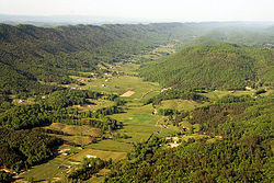
The eastern head of the Ridge and Valley region is marked by the Great Appalachian Valley, which lies just west of the Blue Ridge. The western side of the Ridge and Valley region is marked by steep escarpments such as the Allegheny Front, the Cumberland Mountains, and Walden Ridge. The Valley and Ridge is located on the west side of the Blue Ridge Mountains.

An aerial view of Bedford County, Pennsylvania, showing (from center to right): Wills, Evitts, and Tussey Mountains in December 2006 Bedford-co-air.jpg
An aerial view of Bedford County, Pennsylvania, showing (from center to right): Wills, Evitts, and Tussey Mountains in December 2006

The Province extends from southeastern New York in the north through northwestern New Jersey, westward into Pennsylvania through the Lehigh Valley, and southward into Maryland, West Virginia, Virginia, Kentucky, Tennessee, Georgia, and Alabama. They form a broad arc between the Blue Ridge Mountains and the Appalachian Plateau physiographic province, which includes the Allegheny and Cumberland plateaus. They are characterized by long, even ridges, with long, continuous valleys in between.

Significant ridges (from north to south)

NameState
Shawangunk Ridge New York
Kittatinny Mountain New Jersey
Bald Eagle Mountain Pennsylvania
Blue Mountain Pennsylvania
South Mountain Pennsylvania
Jacks Mountain Pennsylvania
Moosic Mountains Pennsylvania
Nittany Mountain Pennsylvania
Tuscarora Mountain Pennsylvania
Tussey Mountain Pennsylvania
Wills Mountain Pennsylvania and Maryland
Dans Mountain Maryland
Sideling Hill West Virginia, Maryland, and Pennsylvania
Cacapon Mountain West Virginia
Knobly Mountain West Virginia
Mill Creek Mountain West Virginia
New Creek Mountain West Virginia
North Fork Mountain West Virginia
Patterson Creek Mountain West Virginia
Sleepy Creek Mountain West Virginia
South Branch Mountain West Virginia
Spruce Mountain West Virginia
Allegheny Mountain Virginia and West Virginia
Great North Mountain Virginia and West Virginia
North Mountain Virginia and West Virginia
Shenandoah Mountain Virginia and West Virginia
Massanutten Mountain Virginia
Pine Mountain Kentucky, Virginia, and Tennessee
Clinch Mountain Tennessee and Virginia
Powell Mountain Tennessee and Virginia
Bays Mountain Tennessee
House Mountain Tennessee
Sharp's Ridge Tennessee
Taylor Ridge (Georgia) Georgia
Johns Mountain Georgia
Lavender Mountain Georgia
White Oak Mountain Tennessee and Georgia
Missionary Ridge Tennessee and Georgia
Stringer's Ridge Tennessee
Cheaha Mountain Alabama
Red Mountain Alabama


Ridges and valleys near Norton, Virginia in Wise County, Virginia Bristol tenn ridgelines2.jpg
Ridges and valleys near Norton, Virginia in Wise County, Virginia
A map of the Cumberland Plateau and Ridge and Valley Appalachians on the border between Virginia and West Virginia WV plateau.jpg
A map of the Cumberland Plateau and Ridge and Valley Appalachians on the border between Virginia and West Virginia
An aerial view Massanutten Mountain, including the south fork of the Shenandoah River (on left) and part of the Blue Ridge Mountains in Virginia Massanutten-air.jpg
An aerial view Massanutten Mountain, including the south fork of the Shenandoah River (on left) and part of the Blue Ridge Mountains in Virginia

Geology

The Valley and Ridge Province was formed during the Alleghanian orogeny, a mountain-building event that occurred between 325 and 260 million years ago. [2] The rocks in the region were subjected to immense pressure and heat, causing them to deform and fold. The softer parts of these rock units (chiefly shale and limestone) were eroded to form the valleys and the harder parts of the folds (quartzites) formed the mountain tops and ridges. [3] The ridges represent the edges of the erosion-resistant strata, and the valleys portray the absence of the more erodible strata. Smaller streams have developed their valleys following the lines of the more easily eroded strata. [4] [5]

Blue Mountain in the Lehigh Valley region of Pennsylvania Blue Mountain Ridge (Pennsylvania).jpg
Blue Mountain in the Lehigh Valley region of Pennsylvania
Pennsylvania's ridge country seen from Clarks Knob in Franklin County, Pennsylvania Ridgecountry.jpg
Pennsylvania's ridge country seen from Clarks Knob in Franklin County, Pennsylvania

A few major rivers, including the Delaware River, the Susquehanna River, the New River, and the Potomac River, are older than the present mountains, having cut water gaps that are perpendicular to hard strata ridges. The evidence points to a wearing down of the entire region to a low level with little relief, so that major rivers were flowing in unconsolidated sediments unaffected by the underlying rock structure. The region was then uplifted slowly enough so that the rivers could maintain their course, cutting through the ridges as they developed.

Valleys in the region are either synclinal or anticlinal.

These mountains are at their development in central Pennsylvania, a phenomenon termed the Pennsylvania climax.

See also

Related Research Articles

<span class="mw-page-title-main">Appalachian Mountains</span> Mountain range in eastern North America

The Appalachian Mountains, often called the Appalachians, are a mountain range in eastern to northeastern North America. Here, the term "Appalachian" refers to several different regions associated with the mountain range, and its surrounding terrain. The general definition used is one followed by the United States Geological Survey and the Geological Survey of Canada to describe the respective countries' physiographic regions. The US uses the term Appalachian Highlands and Canada uses the term Appalachian Uplands..

<span class="mw-page-title-main">Geology of the Appalachians</span> Geologic description of the Appalachian Mountains

The geology of the Appalachians dates back more than 1.1 billion years to the Mesoproterozoic era when two continental cratons collided to form the supercontinent Rodinia, 500 million years prior to the later development of the range during the formation of the supercontinent Pangea. The rocks exposed in today's Appalachian Mountains reveal elongate belts of folded and thrust faulted marine sedimentary rocks, volcanic rocks and slivers of ancient ocean floor – strong evidence that these rocks were deformed during plate collision. The birth of the Appalachian ranges marks the first of several mountain building plate collisions that culminated in the construction of the supercontinent Pangea with the Appalachians and neighboring Anti-Atlas mountains near the center. These mountain ranges likely once reached elevations similar to those of the Alps and the Rocky Mountains before they were eroded.

<span class="mw-page-title-main">Great Appalachian Valley</span> Major landform in eastern North America

The Great Appalachian Valley, also called The Great Valley or Great Valley Region, is one of the major landform features of eastern North America. It is a gigantic trough, including a chain of valley lowlands, and the central feature of the Appalachian Mountains system. The trough stretches about 1,200 miles (1,900 km) from Quebec in the north to Alabama in the south and has been an important north–south route of travel since prehistoric times.

<span class="mw-page-title-main">Allegheny Mountains</span> Mountain range in the northeastern United States

The Allegheny Mountain Range, informally the Alleghenies, is part of the vast Appalachian Mountain Range of the Eastern United States and Canada and posed a significant barrier to land travel in less developed eras. The Allegheny Mountains have a northeast–southwest orientation, running for about 300 miles (480 km) from north-central Pennsylvania, southward through western Maryland and eastern West Virginia.

<span class="mw-page-title-main">Cumberland Plateau</span> Plateau in the United States

The Cumberland Plateau is the southern part of the Appalachian Plateau in the Appalachian Mountains of the United States. It includes much of eastern Kentucky and Tennessee, and portions of northern Alabama and northwest Georgia. The terms "Allegheny Plateau" and the "Cumberland Plateau" both refer to the dissected plateau lands lying west of the main Appalachian Mountains. The terms stem from historical usage rather than geological difference, so there is no strict dividing line between the two. Two major rivers share the names of the plateaus, with the Allegheny River rising in the Allegheny Plateau and the Cumberland River rising in the Cumberland Plateau in Harlan County, Kentucky.

<span class="mw-page-title-main">Allegheny Plateau</span> Dissected plateau in the eastern United States

The Allegheny Plateau is a large dissected plateau area of the Appalachian Mountains in western and central New York, northern and western Pennsylvania, northern and western West Virginia, and eastern Ohio. It is divided into the unglaciated Allegheny Plateau and the glaciated Allegheny Plateau.

<span class="mw-page-title-main">Cumberland Mountains</span> Mountain range in the southeastern United States

The Cumberland Mountains are a mountain range in the southeastern section of the Appalachian Mountains. They are located in western Virginia, southwestern West Virginia, the eastern edges of Kentucky, and eastern middle Tennessee, including the Crab Orchard Mountains. Their highest peak, with an elevation of 4,223 feet (1,287 m) above mean sea level, is High Knob, which is located near Norton, Virginia.

<span class="mw-page-title-main">Allegheny Front</span> Major escarpment in the Allegheny Mountains

The Allegheny Front is the major southeast- or east-facing escarpment in the Allegheny Mountains in southern Pennsylvania, western Maryland, eastern West Virginia, and western Virginia. The Allegheny Front forms the boundary between the Ridge-and-Valley Appalachians to its east and the Appalachian Plateau to its west. The Front is closely associated with the Appalachian Mountains' Eastern Continental Divide, which in this area divides the waters of the Ohio/Mississippi river system, flowing to the Gulf of Mexico, from rivers flowing into Chesapeake Bay and from there into the Atlantic Ocean.

<span class="mw-page-title-main">Alleghanian orogeny</span> Mountain-forming event that formed the Appalachian and Allegheny Mountains

The Alleghanian orogeny or Appalachian orogeny is one of the geological mountain-forming events that formed the Appalachian Mountains and Allegheny Mountains. The term and spelling Alleghany orogeny was originally proposed by H.P. Woodward in 1957.

<span class="mw-page-title-main">Appalachian Plateau</span> Series of rugged dissected plateaus in the eastern United States

The Appalachian Plateau is a series of rugged dissected plateaus located on the western side of the Appalachian Mountains. The Appalachian Mountains are a range that run from Nova Scotia in Canada to Alabama in the United States.

<span class="mw-page-title-main">Geology of Georgia (U.S. state)</span> Overview of the geology of the U.S. state of Georgia

The U.S. state of Georgia is commonly divided into four geologic regions that influence the location of the state's four traditional physiographic regions. The four geologic regions include the Appalachian foreland, Blue Ridge, Piedmont, and Coastal Plain. These four geologic regions commonly share names with and typically overlap the four physiographic regions of the state: the Appalachian Plateau and adjacent Valley and Ridge; the Blue Ridge; the Piedmont and the Coastal Plain.

<span class="mw-page-title-main">Great Indian Warpath</span> Trails in eastern North America used by Native Americans

The Great Indian Warpath (GIW)—also known as the Great Indian War and Trading Path, or the Seneca Trail—was that part of the network of trails in eastern North America developed and used by Native Americans which ran through the Great Appalachian Valley. The system of footpaths extended from what is now upper New York to deep within Alabama. Various Native peoples traded and made war along the trails, including the Catawba, numerous Algonquian tribes, the Cherokee, and the Iroquois Confederacy. The British traders' name for the route was derived from combining its name among the northeastern Algonquian tribes, Mishimayagat or "Great Trail", with that of the Shawnee and Delaware, Athawominee or "Path where they go armed".

<span class="mw-page-title-main">Bald Eagle Mountain</span>

Bald Eagle Mountain – once known locally as Muncy Mountain – is a stratigraphic ridge in the Ridge-and-Valley Appalachians of central Pennsylvania, United States, running east of the Allegheny Front and northwest of Mount Nittany. It lies along the southeast side of Bald Eagle Creek and south of the West Branch Susquehanna River, and is the westernmost ridge in its section of the Ridge-and-Valley Appalachians. The ridge line separates the West Branch Susquehanna Valley from the Nippenose and White Deer Hole valleys, and Bald Eagle Valley from Nittany Valley.

<span class="mw-page-title-main">Brush Mountain (Blair County, Pennsylvania)</span>

Brush Mountain is a stratigraphic ridge in the Appalachian Mountains of central Pennsylvania, United States, lying east of the Allegheny Front and west of Tussey Mountain. It runs along the southeast side of the Little Juniata River and forms a horseshoe around Sinking Run, and is the westernmost ridge in its section of the Ridge-and-valley Appalachians. The western ridge line separates the Logan Valley from the Sinking Valley.

<span class="mw-page-title-main">Wills Mountain</span>

Wills Mountain is a quartzite-capped ridge in the Ridge and Valley physiographic province of the Appalachian Mountains in Pennsylvania and Maryland, extending from near Bedford, Pennsylvania, to near Cumberland, Maryland. It is the northernmost of several mountain ridges included within the Wills Mountain Anticline.

<span class="mw-page-title-main">Appalachian Highlands</span> Physiographic division of the United States

The Appalachian Highlands is one of eight government-defined physiographic divisions of the contiguous United States. The links with the Appalachian Uplands in Canada to make up the Appalachian Mountains. The Highlands includes seven physiographic provinces, which is the second level in the physiographic classification system in the United States. At the next level of physiographic classification, called section/subsection, there are 20 unique land areas with one of the provinces having no sections.

<span class="mw-page-title-main">Geology of Pennsylvania</span> Overview of the geology of the U.S. state of Pennsylvania

The Geology of Pennsylvania consists of six distinct physiographic provinces, three of which are subdivided into different sections. Each province has its own economic advantages and geologic hazards and plays an important role in shaping everyday life in the state. From the southeast corner to the northwest corner of the state, the include: the Atlantic Plain Province province, the Piedmont Province, the New England Province, the Ridge and Valley Province, the Appalachain Province, and the Central Lowlands Province.

The U.S. state of Tennessee is geographically diverse, with varying terrains and several distinct physiographic regions. Its landforms range from the Blue Ridge Mountains in the eastern part of the state to flat and fertile plains along the Mississippi River. The state is geographically, legally, culturally, and economically divided into three Grand Divisions: East Tennessee, Middle Tennessee, and West Tennessee.

<span class="mw-page-title-main">Blair Gap</span>

Blair Gap, one of the gaps of the Allegheny, is a water gap along the eastern face atop the Allegheny Front escarpment. Like other gaps of the Allegheny, the slopes of Blair Gap were amenable to foot travel, pack mules, and possibly wagons allowing Amerindians, and then, after about 1778–1780 settlers, to travel west into the relatively depopulated Ohio Country decades before the railroads were born and tied the country together with steel.

<span class="mw-page-title-main">Gaps of the Allegheny</span>

The gaps of the Allegheny, meaning gaps in the Allegheny Ridge in west-central Pennsylvania, is a series of escarpment eroding water gaps along the saddle between two higher barrier ridge-lines in the eastern face atop the Allegheny Ridge or Allegheny Front escarpment. The front extends south through Western Maryland and forms much of the border between Virginia and West Virginia, in part explaining the difference in cultures between those two post-Civil War states. While not totally impenetrable to daring and energetic travelers on foot, passing the front outside of the water gaps with even sure footed mules was nearly impossible without navigating terrain where climbing was necessary on slopes even burros would find extremely difficult.

References

  1. "Physiographic divisions of the conterminous U. S." water.usgs.gov. Retrieved September 6, 2023.
  2. Hatcher, R.D. "Tracking lower-to-mid-to-upper crustal deformation processes through time and space through three Paleozoic orogenies in the Southern Appalachians using dated metamorphic assemblages and faults". Geological Society of America Abstracts with Programs. Geological Society of America. Archived from the original on August 6, 2018. Retrieved January 23, 2012.
  3. Stanley, 421-2
  4. Stanley, 421-2
  5. "Valley and Ridge Province (U.S. National Park Service)". www.nps.gov. Retrieved September 6, 2023.

Further reading