Montgomery Village, Maryland

Last updated
Montgomery Village, Maryland
Montgomery Village Foundation, Inc.
Saint John Neumann Church (Montgomery Village, Maryland).JPG
The Saint John Neumann Church in August 2013
Flag of Montgomery Village, Maryland.svg
Seal of Montgomery Village, Maryland.svg
Nickname: 
"MVF" [1]
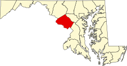
Montgomery County Maryland Incorporated and Unincorporated areas Montgomery Village Highlighted.svg
Location of Montgomery Village in Montgomery County, Maryland
Coordinates: 39°10′35″N77°11′34″W / 39.17639°N 77.19278°W / 39.17639; -77.19278
CountryFlag of the United States.svg United States
State Flag of Maryland.svg  Maryland
County Flag of Montgomery County, Maryland.svg Montgomery
Created1962 (1962)
Foundation incorporated1966 (1966)
Government
  TypeFoundation
  PresidentMatt Brolley
Area
[2]
  Total3.96 sq mi (10.26 km2)
  Land3.88 sq mi (10.05 km2)
  Water0.08 sq mi (0.21 km2)
Elevation
371 ft (113 m)
Population
 (2020)
  Total34,893
  Density8,988.41/sq mi (3,470.42/km2)
Time zone UTC−5 (Eastern (EST))
  Summer (DST) UTC−4 (EDT)
ZIP codes
20877, 20879, 20886
Area code(s) 301, 240
FIPS code 24-53325
GNIS feature ID1712797
Website www.montgomeryvillage.com

Montgomery Village is a census-designated place (CDP) in Montgomery County, Maryland, United States, and a northern suburb of Washington, D.C. It is a large, planned suburban community, developed in the late 1960s and 1970s just outside Gaithersburg's city limits. Montgomery Village's population was 34,893 at the time of the 2020 U.S. Census, [3] and it is a part of the Washington metropolitan area.

Contents

History

1960s

Montgomery Village was created in 1962 by Kettler Brothers, Inc. The vision for a planned community in Gaithersburg is credited to architect Charles Kettler, who incorporated Kettler Brothers with his brothers Milton and Clarence in 1952. The first land purchase was the Walker Farm in 1962. Subsequent purchases were the Thomas Farm, The Mills Farm, The French Farm, The Patton Farm, The Fulks Farm, The Wilson Farm, and The James Walter Deppa property. The Walker Farm was the largest of all the properties the Kettlers bought. It was 412 acres (1.67 km2) and now is Walkers Choice, Cider Mill, Horizon Run, Christopher Court, Dockside, Nathan's Hill, Millrace, the Montgomery Village Library, Montgomery Village Day-Care Center, the Off-Price Centers, Bayberry, the Verandahs, Grover's Forge, Lake Whetstone, South Valley Park, and part of Lakeforest Mall. [4]

On February 28, 1966, the Kettler brothers broke ground for the first house in Montgomery Village. The first model homes were opened in Lakeside of Whetstone in August 1967. The first residents of Montgomery Village moved in on September 25, 1967, in Goshenside.

The Montgomery Village Foundation was incorporated in 1966. In 1968, the Whetstone Community Center opened, as did Whetstone Elementary and Montgomery Village Junior High schools.

1970s

In 1970, The Village Mall opened, which is now the Village Shopping Center on Montgomery Village Avenue. Then in 1971, a Holiday Inn was opened. In 1973, bus service to Washington, D.C., began. [5]

1990s

In 1998, Montgomery Village began using its own ZIP code, 20886. [6]

2000s

In 2007, Montgomery Village's YMCA swimming pool closed. [7]

2010s

The Montgomery Village Golf Club closed November 30, 2014 [8] and will be turned into a neighborhood. [9]

2020s

Montgomery Village is seeing a surge in redevelopment. A firm has purchased the golf course and is approved to move forward with the Bloom Montgomery Village neighborhood featuring an 80-acre park and dog park, new single-family and townhomes. The groundbreaking is scheduled for March 2020 with the first model homes opening in fall 2020.

Montgomery Village 'The Village" currently has a farmers market on Saturdays from May through October, free summer concerts selling beer & wine, 3 summer youth swim teams, All Comers Swim Meet, 3 Community Centers (2 are rentable), annual art show, 4 July parade and carnival and 5k, A great Pumpkin race and fall festival, Brunch with a Bunny, flashlight Easter Egg Hunt, seasonal indoor/outdoor flea markets, Holiday craft bazaar, Annual Thanksgiving morning workout, Community Christmas Tree lighting, Breakfast with Santa, Holiday Toys for Tots Concert, a full year-round recreation program, summer youth camp program, an Active Seniors group with weekly activities, daddy-daughter Valentines Day Dance, wine & paint nights, Bingo nights, September annual dog swim (in one of the many pools) several tennis courts, 7 seasonal swimming pools, a heated pool (extends summer swimming season) paved bike and walking trails, ponds for non-motorized boating and fishing, pedestrian tunnels located under busy roads throughout for pedestrian safety, several parks and tot lots, protected natural streams, public transportation, a new renovated County Library, 2 exits to I-270 (Montgomery Village Ave & Watkins Mill Rd/2020)

Geography

Although Montgomery Village is an unincorporated area, its boundaries are defined according to Montgomery County zoning rules and by its own unique ZIP code. Montgomery Village can use Gaithersburg addresses even though the village is outside city limits. Montgomery Village is recognized by the U.S. Census Bureau as a census-designated place, and by the U.S. Geological Survey as a populated place located at 39°10′35″N77°11′34″W / 39.17639°N 77.19278°W / 39.17639; -77.19278 (39.176469, -77.192654). [10]

According to the U.S. Census Bureau, [11] the place has a total area of 4.055 square miles (10.50 km2), of which 3.974 square miles (10.29 km2) is land and 0.081 square miles (0.21 km2) (1.99%) is water.

Education

Montgomery Village is served by Montgomery County Public Schools. [12]

Elementary schools

Middle schools

High schools

Demographics

Historical population
CensusPop.Note
1980 18,725
1990 32,31572.6%
2000 38,05117.8%
2010 32,032−15.8%
2020 34,8938.9%
source: [13] [14]
2010–2020 [3]

2010

As of the 2010 U.S. Census, there were 32,032 people and 11,751 households residing in the area. [13] The population density was 8,018 people per square mile (3,096 people/km2). [13] There were 12,471 housing units. [13]

The median income for a household in the area was $76,526. [13] The per capita income for the area was $35,389. [13]

2000

As of the 2000 U.S. Census, [15] there were 38,051 people, 14,142 households, and 9,729 families residing in the area. The population density was 5,875.1 inhabitants per square mile (2,268.4/km2). There were 14,548 housing units at an average density of 2,246.2 per square mile (867.3/km2). The ethnic makeup of the area was 38.1% White, 23.2% African American, 0.2% Native American, 10.7% Asian, 0.0% Pacific Islander, 0.5% from other races, and 2.9% from two or more races. Hispanic or Latino of any race were 24.0% of the population.

There were 14,142 households, out of which 36.8% had children under the age of 18 living with them, 52.5% were married couples living together, 12.6% had a female householder with no husband present, and 31.2% were non-families. 24.0% of all households were made up of individuals, and 4.9% had someone living alone who was 65 years of age or older. The average household size was 2.68 and the average family size was 3.21.

In the area, the population was spread out, with 26.6% under the age of 18, 7.5% from 18 to 24, 35.4% from 25 to 44, 23.5% from 45 to 64, and 7.0% who were 65 years of age or older. The median age was 34 years. For every 100 females there were 90.9 males. For every 100 females age 21 and over, there were 87.7 males.

The median income for a household in the area was $66,828, and the median income for a family was $74,920 (these figures had risen to $89,601 and $97,837 respectively as of a 2008 estimate). [16] Males had a median income of $50,046 versus $38,665 for females. The per capita income for the area was $29,620. About 3.9% of families and 7.1% of the population were below the poverty line, including 6.6% of those under age 18 and 3.4% of those age 65 or over.

Related Research Articles

<span class="mw-page-title-main">Washington County, Maryland</span> County in Maryland, United States

Washington County is located in the western part of the U.S. state of Maryland. As of the 2020 census, the population was 154,705. It is the most populous county in the Western Maryland region and its county seat is Hagerstown.

<span class="mw-page-title-main">Gaithersburg, Maryland</span> City in Maryland, United States

Gaithersburg, officially the City of Gaithersburg, is a city in Montgomery County, Maryland, United States. At the time of the 2020 U.S. Census, Gaithersburg had a population of 69,657, making it the ninth-largest community in the state. Gaithersburg is located to the northwest of Washington, and is considered a suburb and a primary city within the Washington–Arlington–Alexandria, DC–VA–MD–WV Metropolitan Statistical Area. Gaithersburg was incorporated as a town in 1878 and as a city in 1968.

<span class="mw-page-title-main">Olney, Maryland</span> Census-designated place in Maryland, United States

Olney is a U.S. census-designated place and an unincorporated area in Montgomery County, Maryland. It is located in the north central part of the county, ten miles (16 km) north of Washington, D.C.

<span class="mw-page-title-main">Chevy Chase Section Five, Maryland</span> Village in Maryland, United States

Chevy Chase Section Five is an incorporated village in Montgomery County, Maryland, United States. The population was 672 at the 2020 census.

<span class="mw-page-title-main">Chevy Chase Section Three, Maryland</span> Village in Maryland, United States

Chevy Chase Section Three is a village in Montgomery County, Maryland, United States. It was organized as a special tax district in 1916 and incorporated as a village in 1982. The population was 802 at the 2020 census.

<span class="mw-page-title-main">Chevy Chase View, Maryland</span> Town in Maryland, United States

Chevy Chase View is a town in Montgomery County, Maryland, United States. Established as a Special Tax District in 1924, the town was formally incorporated on October 28, 1993. The population was 1,005 at the 2020 census.

<span class="mw-page-title-main">Chevy Chase Village, Maryland</span> Town in Maryland, United States

Chevy Chase Village is an incorporated municipality in Montgomery County, Maryland, United States, bordering Washington, D.C. It is made up of sections 1, 1a, and 2 of Chevy Chase, as originally designated by The Chevy Chase Land Company. The population was 2,049 as of the 2020 census. The town was the wealthiest in Maryland as of 2017, with a median income of over $250,000, the highest income bracket listed by the census bureau, and a median home value of $1,823,800.

<span class="mw-page-title-main">Clarksburg, Maryland</span> Census-designated place in Maryland, United States

Clarksburg is a census-designated place and an unincorporated area in northern Montgomery County, Maryland, United States. It is located at the northern end of the Interstate 270 technology corridor, approximately four miles north of Germantown. As of the 2020 census, Clarksburg had a population of 29,051.

<span class="mw-page-title-main">Darnestown, Maryland</span> Census-designated place in the United States

Darnestown is a United States census-designated place (CDP) and an unincorporated area in Montgomery County, Maryland. The CDP is 17.70 square miles (45.8 km2) with the Potomac River as its southern border and the Muddy Branch as much of its eastern border. Seneca Creek borders portions of its north and west sides. The Travilah, North Potomac, and Germantown census-designated places are adjacent to it, as is the city of Gaithersburg. Land area for the CDP is 16.39 square miles (42.4 km2). As of the 2020 census, the Darnestown CDP had a population of 6,723, while the village of Darnestown is considerably smaller in size and population. Downtown Washington, D.C. is about 22 miles (35 km) to the southeast.

<span class="mw-page-title-main">Kemp Mill, Maryland</span> Census-designated place in Maryland, United States

Kemp Mill is a census-designated place and an unincorporated census area in Montgomery County, Maryland, United States. The population was 13,378 at the 2020 census.

<span class="mw-page-title-main">Laytonsville, Maryland</span> Town in Maryland, United States

Laytonsville is a town in Montgomery County, Maryland, United States. The population was 572 at the 2020 census, up from 353 in 2010. Laytonsville was incorporated in 1892.

<span class="mw-page-title-main">Martin's Additions, Maryland</span> Village in Maryland, United States

Martin's Additions is a village in Montgomery County, Maryland, United States. It was established as a Special Tax District in 1916 and incorporated as a village in 1985. The population was 946 at the 2020 Census.

<span class="mw-page-title-main">North Chevy Chase, Maryland</span> Village in Maryland, United States

North Chevy Chase is a village in Montgomery County, Maryland, United States. It was established as a special tax district in 1924 and incorporated as a village in 1996. The population was 682 at the 2020 census, up from 519 in 2010.

<span class="mw-page-title-main">North Kensington, Maryland</span> Census-designated place in Maryland, United States

North Kensington is a census-designated place and an unincorporated area in Montgomery County, Maryland, United States. It had a population of 9,497 in 2020.

<span class="mw-page-title-main">Potomac, Maryland</span> Census-designated place in Maryland, United States

Potomac is an unincorporated community and census-designated place (CDP) in Montgomery County, Maryland. As of the 2020 census, it had a population of 47,018. It is named after the nearby Potomac River.

<span class="mw-page-title-main">Travilah, Maryland</span> Census-designated place in Maryland

Travilah is a United States census-designated place and an unincorporated area in Montgomery County, Maryland. It is 17.28 square miles (44.8 km2) located along the north side of the Potomac River, and surrounded by the communities of Potomac, North Potomac, and Darnestown—all census-designated places. It had a population of 11,985 as of the 2020 census.

<span class="mw-page-title-main">Washington Grove, Maryland</span> Historic district in Maryland, United States

Washington Grove is a town in Montgomery County, Maryland, United States. The population was 505 at the 2020 census. The Washington Grove Historic District was listed on the National Register of Historic Places in 1980.

<span class="mw-page-title-main">Calverton, Maryland</span> Census-designated place in Maryland, United States

Calverton is an unincorporated area and census-designated place located on the boundary between Montgomery and Prince George's counties, Maryland, in the United States. At the 2020 census, it had a population of 17,316.

<span class="mw-page-title-main">Chevy Chase (town), Maryland</span> Town in Montgomery County, Maryland, US

Chevy Chase is an incorporated town in Montgomery County, Maryland, United States. The population was 2,904 at the 2020 census.

<span class="mw-page-title-main">Derwood, Maryland</span> Census-designated place in Maryland, United States

Derwood is an unincorporated area and census-designated place in east-central Montgomery County, Maryland, United States. It lies just north of Rockville, southeast of Gaithersburg, southwest of Olney, and northwest of the greater Silver Spring area. Derwood was originally "Deer Park" and was then "Deer Wood" before getting its current name.

References

  1. "Montgomery Village". www.mvf.org.
  2. "2020 U.S. Gazetteer Files". United States Census Bureau. Retrieved April 26, 2022.
  3. 1 2 "QuickFacts: Montgomery Village CDP, Maryland". United States Census Bureau. Retrieved 17 August 2021.
  4. "Village History | Montgomery Village". montgomeryvillage.com. Retrieved 2016-11-28.
  5. Montgomery Village Foundation – Village History Archived 2008-01-29 at the Wayback Machine
  6. Bates, Jennifer (December 30, 1998). "Top Montgomery Village news stories for 1998". The Gazette. Gaithersburg, Maryland: Post-Newsweek Media, Inc. Archived from the original on March 7, 2012. Retrieved March 7, 2012.{{cite web}}: CS1 maint: unfit URL (link)
  7. "For young and old, the Village YMCA pool will be missed". www.gazette.net. Archived from the original on 28 March 2019. Retrieved 12 January 2022.
  8. O'Connell, Jonathan (April 10, 2014). "In Montgomery Village, turning a golf course into a neighborhood". The Washington Post. Washington, D.C. Retrieved March 10, 2016.
  9. "In Montgomery Village, turning a golf course into a neighborhood - The Washington Post". The Washington Post . 2014-04-10. Retrieved 2017-07-29.
  10. "US Gazetteer files: 2010, 2000, and 1990". United States Census Bureau. 2011-02-12. Retrieved 2011-04-23.
  11. Geography, US Census Bureau. "2016 U.S. Gazetteer Files Record Layouts". www.census.gov. Retrieved 2016-11-28.
  12. "Montgomery County Public Schools, Rockville, MD". gis.mcpsmd.org. Retrieved 2016-11-28.
  13. 1 2 3 4 5 6 United States Census Bureau (February 5, 2015). "Montgomery Village CDP, Maryland". State and County QuickFacts. United States of America: United States Census Bureau. Archived from the original on February 11, 2015. Retrieved February 11, 2015.
  14. "CENSUS OF POPULATION AND HOUSING (1790-2000)". United States Census Bureau . Retrieved July 17, 2010.
  15. "U.S. Census website". United States Census Bureau . Retrieved 2008-01-31.
  16. |04000US24|16000US2467675&_street=&_county=montgomery+village&_cityTown=montgomery+village&_state=04000US24&_zip=&_lang=en&_sse=on&ActiveGeoDiv=geoSelect&_useEV=&pctxt=fph&pgsl=160&_submenuId=factsheet_1&ds_name=ACS_2007_3YR_SAFF&_ci_nbr=null&qr_name=null&reg=null:null&_keyword=&_industry= 2006-2008 American Community Survey 3-Year Estimates [ permanent dead link ]