Eastern Shore of Maryland

Last updated
Eastern Shore of Maryland
Marylandeasternshore.gif
The counties of the Eastern Shore of Maryland
Coordinates: 38°42′N75°48′W / 38.7°N 75.8°W / 38.7; -75.8
CountryUnited States
State Maryland
Largest city Salisbury
Counties
Population
 (2020 Census) [1]
  Total456,815
Time zone UTC−5 (EST)
  Summer (DST) UTC−4 (EDT)

The Eastern Shore of Maryland is a part of the U.S. state of Maryland that lies mostly on the east side of the Chesapeake Bay. Nine counties are normally included in the region. The Eastern Shore is part of the larger Delmarva Peninsula that Maryland shares with Delaware and Virginia.

Contents

As of the 2020 census, its population was 456,815, with about 7% of Marylanders living in the region. The region is politically more conservative than the rest of the state, generally returning more votes for Republicans than Democrats in statewide and national elections.

Developed in the colonial and federal period for agriculture, the Eastern Shore has remained a relatively rural region. Salisbury is the most populous community on the Eastern Shore of Maryland. The region's economy is dominated by three industry sectors: fishing along the coasts, especially for shellfish such as the blue crab; farming, especially large-scale chicken farms; and tourism, especially centered on the Atlantic coast and beach resort of Ocean City. Because of its coastal and low-lying geography, the region is vulnerable to extreme weather events, including hurricanes and larger environmental issues like climate change and rising sea levels.

The region contains a few major roads; the main connection to the other parts of Maryland is the Chesapeake Bay Bridge, which carries U.S. Route 50 and U.S. Route 301. U.S. Route 13 connects the southern part of the Eastern Shore to both Delaware and points north and Virginia and points south.

Geography

Crisfield, a seafood center along Chesapeake Bay CrisfieldWaterfront.jpg
Crisfield, a seafood center along Chesapeake Bay
A farm in Kent County KentCountyMD.jpg
A farm in Kent County
Blackwater National Wildlife Refuge in Dorchester County BlackwaterNWR.jpg
Blackwater National Wildlife Refuge in Dorchester County

The Eastern Shore of Maryland comprises Caroline, Cecil, Dorchester, Kent, Queen Anne's, Somerset, Talbot, Wicomico, and Worcester counties. [2] These lie on the eastern side of the Chesapeake Bay and Susquehanna River, which is the western border of Cecil County with Harford County. The region borders the Mason–Dixon line with Delaware to the east and north, the Atlantic Ocean on the east, and Virginia's Eastern Shore on the south. Maryland's and Virginia's Eastern Shores, along with most of Delaware, form the Delmarva Peninsula.

The location of the southern border with Virginia was a cause for significant dispute amongst colonists prior to 1668, when Phillip Calvert of Maryland and Edmund Scarborough of Virginia demarcated the Calvert-Scarborough Line. This line ran northeast from Watkins Point in the Chesapeake through the James L. Horsey Farm and beyond to the Atlantic, but was ultimately never observed due to poor marking. The line in use today was established under the Award of 1877; this line travels east from Watkins Point, then up the middle of the Pocomoke River before heading due east along the Calvert-Scarborough Line at the point where it intersects the river. [3]

Like New Castle County, Delaware, Cecil County is crossed by the Fall Line, a geologic division where the rockier highlands of the Piedmont region meet the Atlantic coastal plain, a flat, sandy area that forms the coast. The coastal plain includes the Delmarva Peninsula and hence the Eastern Shore of Maryland. The geology of Delmarva is an inseparable part of the Eastern Shore, which has few rocky outcrops south of Kent County.

The Chesapeake and Delaware Canal crosses from Back Creek on the Elk River to Port Penn, Delaware. While it was a shallow canal with locks after its construction in 1829, it was deepened in the early 20th century to sea level, and physically separates the Delmarva Peninsula from the rest of the United States. Maryland south of the canal is considered the Eastern Shore by residents. The term Western Shore is used by Eastern Shore residents to describe all the counties of Maryland west of the Chesapeake Bay, but especially those of the Baltimore-Washington metropolitan area and Southern Maryland.

The north–south section of the Mason–Dixon line forms the border between Maryland and Delaware. The border was originally marked every mile by a stone, and every five miles by a "crownstone". The line is not quite due north and south, but is as straight as survey methods of the 1760s could make it. It was surveyed as a compromise solution to a century-long wrangle over colonial territory between the Penn and Calvert families of England. If the Chesapeake Bay/Delaware Bay watershed divide had been taken as the borderline, the state of Delaware would be about half its current size.

History

Queen Anne's County courthouse 1Queen Anne's Co. courthouse.jpg
Queen Anne's County courthouse

Early history

William Claiborne was granted land that was then part of the Colony of Virginia in 1629. He named it "Kent County". In 1631, he sailed north up the Chesapeake Bay from its south and west side to the area known today as Kent Island. There he made a fortified settlement that is considered to be the first English settlement within the Province of Maryland. Talbot County was formed in 1662. Cecil County was formed in 1674, by proclamation of the Governor, from eastern portions of Baltimore County and the northern portion of Kent County. Wicomico County was formed in 1867, as the 9th and last county, created from Somerset and Worcester counties.

Formation of counties

19th century

Chesapeake Bay Maritime Museum in St. Michaels Chesapeake Bay Maritime Museum.JPG
Chesapeake Bay Maritime Museum in St. Michaels

Ocean City was founded on July 4, 1875, [4] when the Atlantic Hotel opened on Assateague Island. At the time, Assateague Island was continuous from the Delaware state line to well south of Ocean City: the Ocean City Inlet was not formed until a hurricane in August 1933 cut across the south end of the town. The inlet was cut not by waves sweeping inland, but by 4 or 5 days' worth of freshwater runoff from the coastal creeks running seaward. By 1935, government money had built jetties to make the inlet permanent, dividing Fenwick Island (north) from Assateague Island (south). Early transportation to the island was by train.

Until the 1820s, travel and commerce between the Eastern Shore and Baltimore were less important than the connections between it and Philadelphia. Water travel by sailboat and steamer linked the Eastern Shore to Baltimore more tightly beginning about 1813, when the first steamboat traveled the Bay. By the 1880s, railroad lines linked the Eastern Shore to Philadelphia and later, Norfolk, Virginia, by way of a railroad line straight south from Wilmington to Dover, Delmar, Salisbury, and Cape Charles. Maryland's Eastern Shore was served by branch lines running generally southwest from the main route. See List of railroad lines in the Delmarva Peninsula. The Eastern Shore's many branchlines were built after the Civil War by local companies; by the late nineteenth century, all were controlled by the Pennsylvania Railroad (which also bought control of the steamboat and ferry routes), then Conrail and Norfolk Southern. Today the remaining active railroad tracks on the Eastern Shore are operated by short-line railroads Delmarva Central Railroad and the Maryland and Delaware Railroad.

Commercial east–west ties between Delaware towns and Maryland towns were culturally significant in Colonial and Early American periods despite the border line, which largely cut through woods and swamps. Trade with Philadelphia was conducted by overland routes to Delaware towns such as Odessa (then called Cantwell's Bridge) and Smyrna, then called Duck Creek. Agricultural products and milled grain were taken up the Delaware River by "shallop men" in small vessels called shallops. These cultural connections continue to this day.

20th and 21st centuries

An east–west rail route ran from a ferry terminal at Claiborne, west of St. Michaels, to Ocean City, via the Baltimore and Eastern Shore Railroad and the Wicomico and Pocomoke Railroad. Travelers could also take a ferry to Love Point on Kent Island, board a Queen Anne's Railroad train, and travel east to Lewes and Rehoboth Beach, Delaware.

Automobile transportation across the Chesapeake Bay was by ferryboat until 1952, when the first Chesapeake Bay Bridge was opened for traffic.

In the late 1950s and early 1960s, developers began selling lots on Assateague Island, south of the inlet. However, a storm on March 6, 1962 destroyed houses, shacks, and roads. [5] The state and federal governments intervened before reconstruction by creating the Assateague Island National Seashore and Assateague State Park to preserve this area rather than have it be developed.

An Eastern Shore Baseball League operated during three periods between 1922 and 1949. [6] It was a Class D minor league with teams in all three states of Delmarva.

Demographics

Although the Eastern Shore comprises a large part of Maryland's land area, it had a population of 456,815 as of the 2020 Census, representing about 7.4% of Maryland's total population. [1] [7] The most populous city in the region is Salisbury, and the most populous county is Cecil. [8] [1]

Elections

The Eastern Shore is considerably more conservative than the more densely populated and urban Western Shore. Since the late 20th century, when conservative whites shifted to the Republican Party, the region has strongly supported Republican candidates for governor. The three Republican nominees for governor from 1994 to 2018Ellen Sauerbrey, Bob Ehrlich, and Larry Hogan– swept all nine counties. This streak ended in 2022 when Democrat Wes Moore won Kent and Talbot counties, though Republican Dan Cox still won the Eastern Shore overall.

At the presidential level, the Eastern Shore also leans Republican. But Kent and Somerset counties have flipped back and forth in supporting Democratic and Republican presidential candidates. The last Democrat to win Dorchester County was Bill Clinton from Arkansas in 1996. Cecil County has not gone Democratic since Jimmy Carter from Georgia won the county in 1976. Queen Anne's, Caroline, Wicomico, and Worcester counties have voted Republican at every election subsequent to Lyndon Johnson's landslide. Up until 2020, this was true for Talbot County as well, but it was won by Joe Biden. [9]

The Eastern Shore has long been a part of Maryland's 1st Congressional district. [10] Democrat Roy Dyson represented the 1st district from 1981 until 1990, when he was defeated by Republican Wayne Gilchrest. Gilchrest held the seat until 2008, when State Senator Andy Harris defeated him in the Republican primary. Harris narrowly lost the subsequent general election to Democrat Frank Kratovil, Queen Anne's County state's attorney. In 2010, Harris again ran for the district and handily defeated Kratovil after a single term in office. Harris has held the seat without serious difficulty since.

In the Maryland General Assembly, the Eastern Shore encompasses a portion of district 35B and all of districts 35A, 36, 37A and 37B, 38A, 38B and 38C. All seats are held by Republicans except for a state delegate seat in district 37A.

Gubernatorial election results
Year Republican Democratic OtherTotal
2022 [11] 55.33%91,42541.24%68,1373.43%5,661165,223
2018 [12] 75.80%131,64923.02%39,9861.16%1,279173,657
2014 [13] 71.45%100,60826.93%37,9191.62%2,277140,804
2010 [14] 59.35%92,23138.19%59,3432.46%3,827155,401
2006 [15] 62.05%90,31936.92%53,7481.03%1,502145,569
2002 [16] 68.07%90,00031.19%41,2410.73%970132,211
1998 [17] 59.02%66,43440.94%46,0790.04%50112,563
1994 [18] 62.60%65,58537.40%39,1870.00%3104,775
1990 [19] 59.43%52,28840.57%35,6920.00%087,980
Presidential election results
Presidential election results [20]
Year Democratic Republican Others
2020 41.0% 94,71656.6%130,6222.4% 5,588
2016 36.3% 77,10458.4%123,9915.3% 11,329
2012 42.0% 86,87956.0%115,6692.0% 4,062
2008 42.9% 87,70055.5%113,5181.6% 3,285
2004 38.8% 71,43560.1%110,6611.1% 1,942
2000 43.0% 64,33653.7%80,3293.2% 4,787
1996 42.8% 54,53746.7%59,52210.6% 13,510
1992 36.5% 50,12144.1%60,51819.4% 26,713
1988 36.3% 41,79763.3%72,8860.5% 551
1984 32.5% 34,93467.1%72,2350.4% 454
1980 42.9% 43,44751.3%52,0005.8% 5,919
1976 48.6% 43,83851.4%46,301
1972 27.5% 23,21571.2%60,0201.3% 1,088
1968 30.0% 25,50646.6%39,57823.3% 19,808
1964 57.0%45,89943.0% 34,585
1960 47.1% 38,72252.9%43,534

Economy

Tourism

Ocean City, Maryland's beach, looking north from the pier Ocean City MD beach looking north from pier.jpeg
Ocean City, Maryland's beach, looking north from the pier

Ocean City's skyline, containing tall hotels and condominiums, stands out within Delmarva. At the southern end of the town, a recreational boardwalk spans over thirty blocks, containing carnival rides and games, restaurants, bars, arcades, and clothing boutiques.

Tourists visit St. Michaels on a neck surrounded by water; the colonial former port of Oxford; Chestertown; and isolated Smith Island in the Chesapeake Bay. North of Crisfield is Janes Island State Park, with camping and kayaking trails through marshlands. Cambridge continues to be a popular destination for tourism because of the Blackwater National Wildlife Refuge, the Hyatt Chesapeake Bay Resort, Spa & Marina, and the Harriet Tubman National Park.

Fishing

At the southern end of the Chesapeake coast of Maryland, the town of Crisfield is home to a fishing, crabbing, and seafood processing industry.

Agriculture

In the 21st century, the main economic activities on the Eastern Shore are vegetable and grain farming, seafood, large-scale chicken breeding (Perdue Farms was founded in Salisbury and is still headquartered there today), and tourism. Tobacco was the chief commodity crop during colonial times. The agricultural economy switched to mixed products, including grain, in the second half of the 18th century. [21] [ unreliable source? ]

Energy

Energy in the Eastern shore is provided by five oil and natural gas plants. [22]

Pipeline

Environment

As part of the broader Chesapeake Bay watershed, the Eastern Shore confronts common environmental issues of the watershed, such as nutrient runoff from agriculture, but it is also vulnerable to climate change.

Because of its low-lying geography and sandy soil, the region is particularly vulnerable to sea level rise and salt water intrusion. [23] Moreover, because of the coastal geography, infrastructure is already being damaged both due to sea level rise, and storm surge from tropical storms and hurricanes. [23]

The Eastern Shore's economy depends on the larger fisheries and farming, both of which are sensitive to climate change. [23]

Transportation

Chesapeake Bay Bridge, which connects the Eastern Shore with the Washington, D.C. and Baltimore metropolitan area and the rest of Maryland Chesapeake Bay Bridge MD1.jpg
Chesapeake Bay Bridge, which connects the Eastern Shore with the Washington, D.C. and Baltimore metropolitan area and the rest of Maryland

Various waterways provide a medium for commerce and boaters: the Atlantic Ocean, Chesapeake Bay, the Susquehanna River, and the Chesapeake and Delaware Canal.

There are three major routes to the Eastern Shore:

The two major highways on the Eastern Shore are U.S. Route 13 and U.S. Route 50, which meet in Salisbury.

Airports

Salisbury-Ocean City Wicomico Regional Airport, in Salisbury, [25] is the only commercial airport on the Delmarva Peninsula.

Airports for private aircraft include:

Secession

The Eastern Shore has made several attempts to separate from Maryland. Proposals were debated in Maryland's General Assembly in 1833–1835, 1852, and 1998. There were earlier proposals visualizing a state encompassing the Delmarva Peninsula. The 1998 proposal by state Senators Richard F. Colburn and J. Lowell Stoltzfus did not specify a status for Eastern Shore's nine counties following secession, but suggested the new state's name could be "Delmarva". [31]

Sports

Arthur W. Perdue Stadium, home of the Delmarva Shorebirds Minor League baseball team Shorebirdsgame.jpg
Arthur W. Perdue Stadium, home of the Delmarva Shorebirds Minor League baseball team

The Delmarva Shorebirds are a minor league baseball team who play Class A baseball in the South Atlantic League at Arthur W. Perdue Stadium in Salisbury, affiliated with the Baltimore Orioles.

Notable people

Towns and cities

County seats:

See also

Related Research Articles

<span class="mw-page-title-main">Delmarva Peninsula</span> Large peninsula on the East Coast of the US

The Delmarva Peninsula, or simply Delmarva, is a large peninsula and proposed state on the East Coast of the United States, occupied by the vast majority of the state of Delaware and parts of the Eastern Shore of Maryland and Eastern Shore of Virginia.

<span class="mw-page-title-main">Somerset County, Maryland</span> County in Maryland, United States

Somerset County is the southernmost county in the U.S. state of Maryland. As of the 2020 census, the population was 24,620, making it the second-least populous county in Maryland. The county seat is Princess Anne.

<span class="mw-page-title-main">Worcester County, Maryland</span> County in Maryland, United States

Worcester County is the easternmost county of the U.S. state of Maryland. As of the 2020 census, the population was 52,460. Its county seat is Snow Hill.

<span class="mw-page-title-main">Crisfield, Maryland</span> City in Maryland, United States

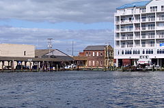
Crisfield is a city in Somerset County, Maryland, United States, located on the Tangier Sound, an arm of the Chesapeake Bay. The population was 2,515 at the 2020 census. It is included in the Salisbury, Maryland-Delaware Metropolitan Statistical Area. Crisfield has the distinction of being the southernmost incorporated city in Maryland.

<span class="mw-page-title-main">Eastern Shore of Virginia</span> Region of Accomack and Northampton counties, Virginia, United States

The Eastern Shore of Virginia is the easternmost region of the Commonwealth of Virginia in the United States. It consists of two counties on the Atlantic coast. It is detached from the mainland of Virginia by the Chesapeake Bay. The 70-mile-long (110 km) region is part of the Delmarva Peninsula. Its population was 45,695 as of 2020.

<span class="mw-page-title-main">Kent Island (Maryland)</span> Largest Island and historic place in the Chesapeake Bay, United States

Kent Island is the largest island in the Chesapeake Bay and a historic place in Maryland. To the east, a narrow channel known as the Kent Narrows barely separates the island from the Delmarva Peninsula, and on the other side, the island is separated from Sandy Point, an area near Annapolis, by roughly four miles (6.4 km) of water. At only four miles wide, the main waterway of the bay is at its narrowest at this point and is spanned here by the Chesapeake Bay Bridge. The Chester River runs to the north of the island and empties into the Chesapeake Bay at Kent Island's Love Point. To the south of the island lies Eastern Bay. The United States Census Bureau reports that the island has 31.62 square miles (81.90 km2) of land area.

<span class="mw-page-title-main">Salisbury–Ocean City–Wicomico Regional Airport</span> Airport in Maryland, U.S.

Salisbury-Ocean City: Wicomico Regional Airport, or, more succinctly Salisbury Regional Airport, is located in unincorporated Wicomico County, Maryland, 5 miles (8.0 km) southeast from downtown Salisbury, Maryland, United States. Salisbury is the largest metropolitan area of Maryland's Eastern Shore with a population of 405,803 in the metropolitan statistical area, and is centrally located on the Delmarva Peninsula.

<span class="mw-page-title-main">U.S. Route 50 in Maryland</span> Section of U.S. Highway in Maryland, United States

U.S. Route 50 is a major east–west route of the U.S. Highway system, stretching just over 3,000 miles (4,800 km) from West Sacramento, California, east to Ocean City, Maryland, on the Atlantic Ocean. In the U.S. state of Maryland, US 50 exists in two sections. The longer of these serves as a major route connecting Washington, D.C., with Ocean City; the latter is the eastern terminus of the highway. The other section passes through the southern end of Garrett County for less than 10 miles (16 km) as part of the Northwestern Turnpike, entering West Virginia at both ends. One notable section of US 50 is the dual-span Chesapeake Bay Bridge across the Chesapeake Bay, which links the Baltimore–Washington metropolitan area with the Eastern Shore region, allowing motorists to reach Ocean City and the Delaware Beaches.

<span class="mw-page-title-main">U.S. Route 13 in Maryland</span> U.S. Highway in Maryland

U.S. Route 13 (US 13) is a United States Numbered Highway running from Fayetteville, North Carolina, north to Morrisville, Pennsylvania. In the U.S. state of Maryland, the route runs 42.48 miles (68.36 km) from the Virginia border south of Pocomoke City in Worcester County north to the Delaware border in Delmar, Wicomico County, where the route intersects Maryland Route 54 (MD 54)/Delaware Route 54 (DE 54), which runs along the state line. The majority of the route within Maryland is a four-lane divided highway that passes through rural areas of woodland and farmland. The route also runs through a few municipalities including Pocomoke City and Princess Anne and it bypasses Fruitland and Salisbury to the east on the Salisbury Bypass, which is a freeway. US 13 intersects many major roads including the southern terminus of US 113 in Pocomoke City, MD 413 in Westover, and MD 12 and US 50 where the route is on the Salisbury Bypass. The route shares a concurrency with US 50 along a portion of the Salisbury Bypass.

<span class="mw-page-title-main">Jeannie Haddaway</span> American politician

Jeannie Haddaway-Riccio is a politician from Maryland who served as Secretary of the Maryland Department of Natural Resources. She previously served as the deputy chief of staff to Maryland Governor Larry Hogan (2016–2019); as director of intergovernmental affairs for Hogan (2015–2016); and as a member of the Maryland House of Delegates, from District 37B (2003–2015).

<span class="mw-page-title-main">Richard F. Colburn</span> American politician

Richard F. Colburn, a Republican, is a former State Senator for District 37 in Maryland.

The Salisbury, MD-DE Metropolitan Statistical Area is a United States Census Bureau-designated metropolitan area centered in and around Salisbury, Maryland, including four counties: Somerset, Wicomico, and Worcester in Maryland; and Sussex in Delaware.

<span class="mw-page-title-main">Union Station (Salisbury, Maryland)</span> Historic railway station in Maryland, US

Union Station is a historic railway station located at Salisbury, Wicomico County, Maryland, United States. It was constructed in 1913–14, near the junction where the New York, Philadelphia & Norfolk Railroad intersected with the Baltimore, Chesapeake and Atlantic Railroad in the center of Salisbury. Both railroads became part of the Pennsylvania Railroad (PRR). It has a 1+12-story, Flemish bond brick main block covered by a medium-pitched hip roof sheathed in slate, with single-story wings. From the 1920s to the 1950s, the PRR ran several passenger trains a day, including the Del-Mar-Va Express, through the station, north–south from Philadelphia to Cape Charles, Virginia.

The Baltimore, Chesapeake and Atlantic railroad, nicknamed Black Cinders & Ashes, ran from Claiborne, Maryland, to Ocean City, Maryland. It operated 87 miles (140.0 km) of center-line track and 15.6 miles (25.11 km) of sidings. Chartered in 1886, the railroad started construction in 1889 and cost $2.356 million ($2024=76,736,000).

<span class="mw-page-title-main">1964 United States presidential election in Maryland</span> U.S. presidential election in Maryland

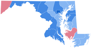
The 1964 United States presidential election in Maryland took place on November 3, 1964, as part of the 1964 United States presidential election. State voters chose 10 representatives, or electors, to the Electoral College, who voted for president and vice president.

Mindie Burgoyne is an American writer and businessperson. She works for the Maryland Department of Business and Economic Development and has written several books about the history and folklore of the Eastern Shore of Maryland. She is the founder and owner of Chesapeake Ghost Walks.

<span class="mw-page-title-main">Carl Anderton Jr.</span> American politician

Carl Anderton Jr. is a Republican member of the Maryland House of Delegates representing district 38B.

<span class="mw-page-title-main">1986 Maryland gubernatorial election</span> Election for governor of Maryland, U.S.

The 1986 Maryland gubernatorial election was held on November 4, 1986. Democratic nominee William Donald Schaefer defeated Republican nominee Thomas J. Mooney with 82.37% of the vote. To date this is the largest percentage total ever for a contested statewide election in Maryland.

<span class="mw-page-title-main">1932 United States presidential election in Maryland</span> U.S. presidential election in Maryland

The 1932 United States presidential election in Maryland took place on November 8, 1932, as part of the 1932 United States presidential election. State voters chose eight representatives, or electors, to the Electoral College, who voted for president and vice president.

<span class="mw-page-title-main">1872 United States presidential election in Maryland</span> U.S. presidential election in Maryland

The 1872 United States presidential election in Maryland took place on November 5, 1872. All contemporary 37 states were part of the 1872 United States presidential election. The state voters chose eight electors to the Electoral College, which selected the president and vice president.

References

  1. 1 2 3 Maryland Department of Planning. "2020 and 2010 Census Population by Jurisdiction" (PDF). Maryland.gov. Retrieved July 1, 2023.
  2. "About Maryland's Eastern Shore". Maryland.com.
  3. Clark, Charles Branch (1950). The Eastern Shore of Maryland and Virginia. Vol. 1. Lewis Historical Publishing Co. pp. 232–233. OCLC   3198545.
  4. Ocean City History Archived 2008-05-13 at the Wayback Machine . ococean.com. Retrieved July 1, 2008.
  5. Assateague Island Administrative History Archived 2011-06-29 at the Wayback Machine The Becoming of the Seashore
  6. MLB Top 100 Teams Archived 2008-06-22 at the Wayback Machine . MLB.com. Retrieved July 1, 2008.
  7. "QuickFacts: Maryland". United States Census Bureau . Retrieved July 1, 2023.
  8. "Maryland Regions". VisitMaryland. Retrieved July 1, 2023.
  9. Sullivan, Robert David; ‘How the Red and Blue Map Evolved Over the Past Century’ Archived 2016-11-16 at the Wayback Machine ; America Magazine, in The National Catholic Review; June 29, 2016
  10. "Maryland Election Districts Map". mdelect.net. Retrieved 4 May 2018.[ permanent dead link ]
  11. "Official 2022 Gubernatorial General Election Results for Governor / Lt. Governor". elections.maryland.gov. Retrieved 2023-03-30.
  12. "Data Files for the 2018 Gubernatorial Election Results". elections.maryland.gov. Retrieved 2019-01-05.
  13. "2014 Gubernatorial Election". elections.maryland.gov. Retrieved 2019-01-05.
  14. "2010 Gubernatorial Elections". elections.maryland.gov. Retrieved 2019-01-05.
  15. "2006 Gubernatorial Election". elections.maryland.gov. Retrieved 2019-01-05.
  16. "2002 Gubernatorial Election". elections.maryland.gov. Retrieved 2019-01-05.
  17. "1998 Gubernatorial Elections". elections.maryland.gov. Retrieved 2019-01-05.
  18. "1994 Gubernatorial Elections". elections.maryland.gov. Retrieved 2019-01-05.
  19. "1990 Gubernatorial Elections". elections.maryland.gov. Retrieved 2022-02-01.
  20. "Our Campaigns" . Retrieved February 20, 2021.
  21. The Encyclopedia Americana: A Library of Universal Knowledge, Encyclopedia Americana Corp., 1919, p. 352, retrieved 2008-03-02
  22. "The Future of Power Generation on the Eastern Shore". www.commonsenseeasternshore.org. 2019-03-20. Retrieved 2020-12-11.
  23. 1 2 3 "What Climate Change Means for Maryland" (PDF). United States Environmental Protection Agency. August 2016.
  24. Baltimore Sun - Chesapeake Bay Bridge Summary. baltimoresun.com. Retrieved July 1, 2008.
  25. Wicomico County Tourism Transportation
  26. Queen Anne's County Bay Bridge Airport
  27. Dorchester County, Maryland Archived 2011-04-01 at the Wayback Machine Airport Division
  28. Somerset County, Maryland Airport
  29. Talbot County Government Archived 2011-04-19 at the Wayback Machine Airport Information
  30. Town of Ocean City Archived 2011-04-02 at the Wayback Machine Official Ocean City Municipal Airport
  31. Michael Dresser (February 11, 1998). "Saying so long to city bullies". The Baltimore Sun. Archived from the original on January 11, 2013.
  32. Lynch, Heather (1998-02-11). "Johnson recalled in a landside". The Daily Times. p. 1. Retrieved 2023-07-15 via Newspapers.com.
  33. "Birckhead Appointed Adjutant General By Governor; Snow Hill Alumna Becomes Nation's First Black Woman To Lead State Military In Country". News Ocean City Maryland Coast Dispatch Newspaper. 2023-04-11. Retrieved 2023-07-02.
  34. "Education Makers, Earl S. Richardson". The History Makers (www.thehistorymakers.com). Retrieved May 1, 2015.
  35. "Paul S. Sarbanes, U.S. Senator (Maryland)". msa.maryland.gov. Archived from the original on 2 March 2018. Retrieved 4 May 2018.