South Gate, Maryland

Last updated
South Gate, Maryland
Anne Arundel County Maryland Incorporated and Unincorporated areas South Gate Highlighted.svg
Location of South Gate, Maryland
Coordinates: 39°7′56″N76°37′52″W / 39.13222°N 76.63111°W / 39.13222; -76.63111 Coordinates: 39°7′56″N76°37′52″W / 39.13222°N 76.63111°W / 39.13222; -76.63111
CountryFlag of the United States.svg United States
State Flag of Maryland.svg  Maryland
County Flag of Anne Arundel County, Maryland.png Anne Arundel
Area
  Total6.3 sq mi (16.3 km2)
  Land6.3 sq mi (16.3 km2)
  Water0.0 sq mi (0.0 km2)
Elevation
66 ft (20 m)
Population
 (2000)
  Total28,672
  Density4,543.9/sq mi (1,754.4/km2)
Time zone UTC−5 (Eastern (EST))
  Summer (DST) UTC−4 (EDT)
FIPS code 24-73550
GNIS feature ID1867301

South Gate was a census-designated place (CDP) in Anne Arundel County, Maryland, United States, for the 2000 census, at which time its population was 28,672. It was added primarily to the Glen Burnie CDP for the 2010 census.

Contents

Geography

South Gate is located at 39°7′56″N76°37′52″W / 39.13222°N 76.63111°W / 39.13222; -76.63111 (39.132358, 76.631126). [1]

According to the United States Census Bureau, the CDP had a total area of 6.3 square miles (16 km2), all land.

Demographics

As of the census [2] of 2000, there were 28,672 people, 11,273 households, and 7,372 families living in the CDP. The population density was 4,543.9 inhabitants per square mile (1,754.4/km2). There were 11,750 housing units at an average density of 1,862.1 per square mile (719.0/km2). The racial makeup of the CDP was 70.94% White, 19.64% African American, 0.35% Native American, 5.28% Asian, 0.09% Pacific Islander, 1.30% from other races, and 2.39% from two or more races. Hispanic or Latino of any race were 3.14% of the population.

There were 11,273 households, out of which 35.0% had children under the age of 18 living with them, 45.0% were married couples living together, 15.3% had a female householder with no husband present, and 34.6% were non-families. 25.9% of all households were made up of individuals, and 4.2% had someone living alone who was 65 years of age or older. The average household size was 2.53 and the average family size was 3.06.

In the CDP, the population was spread out, with 25.9% under the age of 18, 10.9% from 18 to 24, 35.8% from 25 to 44, 20.6% from 45 to 64, and 6.8% who were 65 years of age or older. The median age was 32 years. For every 100 females, there were 95.5 males. For every 100 females age 18 and over, there were 92.8 males.

The median income for a household in the CDP was $48,867, and the median income for a family was $55,780. Males had a median income of $37,529 versus $27,924 for females. The per capita income for the CDP was $22,061. About 5.1% of families and 6.5% of the population were below the poverty line, including 8.5% of those under age 18 and 2.4% of those age 65 or over.

Related Research Articles

<span class="mw-page-title-main">Littletown, Arizona</span> CDP in Pima County, Arizona

Littletown was a census-designated place (CDP) in Pima County, Arizona, United States. The population was 1,010 at the 2000 census. The area was annexed into Tucson in 2017.

<span class="mw-page-title-main">Ferndale, Maryland</span> Census-designated place in Maryland, United States

Ferndale is a census-designated place (CDP) in Anne Arundel County, Maryland, United States. At the 2010 census, the population was 16,746.

<span class="mw-page-title-main">Edgemere, Maryland</span> Census-designated place in Maryland, United States

Edgemere is an unincorporated community and census-designated place in Baltimore County, Maryland, United States. The population was 8,669 at the 2010 census. Founded in 1899 as Edgemere being renamed from previous name "Fitzell". Meeting held at the Fitzell Farm which was situated where the old Rheem plant was located.

<span class="mw-page-title-main">Rossville, Maryland</span> Census-designated place in Maryland, United States

Rossville is an unincorporated community and census-designated place in Baltimore County, Maryland, United States. The population was 15,147 at the 2010 census.

<span class="mw-page-title-main">Calvert Beach-Long Beach, Maryland</span> Former Census-designated place in Maryland, United States

Calvert Beach-Long Beach was a census-designated place (CDP) in Calvert County, Maryland, United States. The population was 2,487 at the 2000 census. For the 2010 census the area was split into two CDPs: Calvert Beach and Long Beach.

<span class="mw-page-title-main">Potomac Heights, Maryland</span> Census-designated place in Maryland, United States

Potomac Heights is a census-designated place (CDP) in Charles County, Maryland, United States. The population was 1,117 at the 2010 census. It has a volunteer fire department and numerous older rambler homes built for workers at the nearby U.S. Navy munitions plant in Indian Head.

<span class="mw-page-title-main">Linganore-Bartonsville, Maryland</span> Former Census-designated place in Maryland

Linganore-Bartonsville was a census-designated place (CDP) in Frederick County, Maryland, United States, for the 2000 census, at which time its population was 12,529. For the 2010 census the area was split into three CDPs: Linganore, Bartonsville, and Spring Ridge.

<span class="mw-page-title-main">West Monroe, Michigan</span> Census-designated place & unincorporated community in Michigan, United States

West Monroe is an unincorporated community and census-designated place (CDP) in Monroe County in the U.S. state of Michigan. The population was 3,227 at the 2020 census. The CDP is located within Monroe Charter Township.

<span class="mw-page-title-main">Whittingham, New Jersey</span> Census-designated place in New Jersey, United States

Whittingham, also known as Greenbriar at Whittingham, is an unincorporated community and census-designated place (CDP) located within Monroe Township, in Middlesex County, New Jersey, United States. As of the 2010 United States Census, the CDP's population was 2,476. The area is focused around the age-restricted gated community of Whittingham.

Evening Shade is a census-designated place (CDP) in Sequoyah County, Oklahoma, United States. It is part of the Fort Smith, Arkansas-Oklahoma Metropolitan Statistical Area. The population was 359 at the 2010 census.

<span class="mw-page-title-main">Iola, Pennsylvania</span> Census-designated place in Pennsylvania, United States

Iola is a census-designated place in Columbia County, Pennsylvania. It is part of Northeastern Pennsylvania. The population was 144 at the 2010 census. It is part of the Bloomsburg–Berwick Micropolitan Statistical Area.

<span class="mw-page-title-main">Skyline View, Pennsylvania</span> Census-designated place in Pennsylvania, United States

Skyline View is an unincorporated community and census-designated place (CDP) in West Hanover Township, Dauphin County, Pennsylvania, United States. The population was 4,003 at the 2010 census, up from 2,307 at the 2000 census. It is part of the Harrisburg–Carlisle Metropolitan Statistical Area.

<span class="mw-page-title-main">Emigsville, Pennsylvania</span> CDP in Pennsylvania, United States

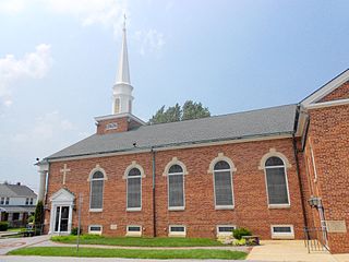
Emigsville is a census-designated place (CDP) in York County, Pennsylvania, United States. The population was 2,672 at the 2010 census.

<span class="mw-page-title-main">Grantley, Pennsylvania</span> CDP in Pennsylvania, United States

Grantley is a census-designated place (CDP) in York County, Pennsylvania, United States. The population was 3,628 at the 2010 census.

<span class="mw-page-title-main">Parkville, Pennsylvania</span> CDP in Pennsylvania, United States

Parkville is a census-designated place (CDP) in York County, Pennsylvania, United States. The population was 6,706 at the 2010 census.

<span class="mw-page-title-main">Pennville, Pennsylvania</span> CDP in Pennsylvania, United States

Pennville is a census-designated place (CDP) in York County, Pennsylvania, United States. The population was 1,947 at the 2010 census.

<span class="mw-page-title-main">Spry, Pennsylvania</span> CDP in Pennsylvania, United States

Spry is a census-designated place (CDP) in York County, Pennsylvania, United States. The population was 4,891 at the 2010 census.

<span class="mw-page-title-main">Susquehanna Trails, Pennsylvania</span> CDP in Pennsylvania, United States

Susquehanna Trails is a census-designated place (CDP) in York County, Pennsylvania, United States. The population was 2,264 at the 2010 census.

<span class="mw-page-title-main">Valley View, York County, Pennsylvania</span> CDP in Pennsylvania, United States

Valley View is a census-designated place (CDP) in York County, Pennsylvania, United States. The population was 2,817 at the 2010 census.

<span class="mw-page-title-main">Weigelstown, Pennsylvania</span> CDP in Pennsylvania, United States

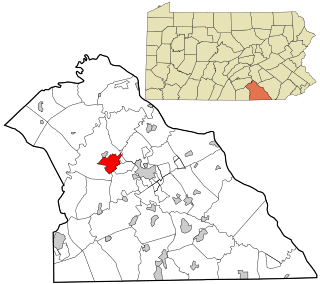
Weigelstown is a census-designated place (CDP) in York County, Pennsylvania, United States. The population was 12,875 at the 2010 census.

References

  1. "US Gazetteer files: 2010, 2000, and 1990". United States Census Bureau. 2011-02-12. Retrieved 2011-04-23.
  2. "U.S. Census website". United States Census Bureau . Retrieved 2008-01-31.