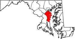
Arundel Gardens, Maryland | |
---|---|
Coordinates: 39°12′45″N76°37′08″W / 39.21250°N 76.61889°W | |
Country | United States |
State | Maryland |
County | Anne Arundel |
Elevation | 48 m (157 ft) |
Time zone | UTC−5 (Eastern (EST)) |
• Summer (DST) | UTC−4 (EDT) |
Area codes | 410 & 443 |
GNIS feature ID | 589658 [1] |
Arundel Gardens is an unincorporated community in Anne Arundel County, Maryland, United States. [2] Arundel Gardens is located along Maryland Route 2 north of Interstate 695, in the southern part of the Brooklyn Park census-designated place. [3]
Anne Arundel County, also notated as AA or A.A. County, is located in the U.S. state of Maryland. As of the 2020 United States census, its population was 588,261, an increase of just under 10% since 2010. Its county seat is Annapolis, which is also the capital of the state. The county is named for Anne Arundell, Lady Baltimore, a member of the ancient family of Arundells in Cornwall, England, and the wife of Cecilius Calvert, 2nd Baron Baltimore (1605–1675), founder and first lord proprietor of the colony Province of Maryland.
Annapolis is the capital city of the U.S. state of Maryland and the county seat of, and only incorporated city in, Anne Arundel County. Situated on the Chesapeake Bay at the mouth of the Severn River, 25 miles (40 km) south of Baltimore and about 30 miles (50 km) east of Washington, D.C., Annapolis forms part of the Baltimore–Washington metropolitan area. The 2020 census recorded its population as 40,812, an increase of 6.3% since 2010.
Crofton is a census-designated place and planned community in Anne Arundel County, Maryland, United States, located 9.8 miles (15.8 km) west of the state capital Annapolis, 24 miles (39 km) south of Baltimore, and 24 miles (39 km) east-northeast of Washington, D.C. The community was established in 1964 and as of the 2020 census, it had a population of 29,136.
Crownsville is a census-designated place (CDP) in Anne Arundel County, Maryland, United States. The population was 1,757 at the 2010 census. It hosts the Anne Arundel County Fair each September, as well as the annual Maryland Renaissance Festival for several summer weekends. A state psychiatric hospital was formerly in Crownsville. The area offers waterfront scenery and easy access to urban metropolitan areas and culture.
Fort Meade is a census-designated place (CDP) in Anne Arundel County, Maryland, United States. The population was 9,327 at the 2010 census. It is the home to the National Security Agency, Central Security Service, United States Cyber Command and the Defense Information Systems Agency, which are located on the U.S. Army post Fort George G. Meade.
Maryland City is a census-designated place (CDP) in Anne Arundel County, Maryland, United States. The population was 16,093 at the 2010 census. It is located east of Laurel, just over the border with Prince George's County, and it has a Laurel ZIP Code. Maryland City mostly consists of an older, compact housing development and is adjacent to Fort Meade army base. A large newer development on the north side of Maryland Route 198 is known as Russett and is included within the Maryland City CDP.
Odenton is a census-designated place (CDP) in Anne Arundel County, Maryland, United States, located approximately 10–20 minutes from the state capital, Annapolis. The population was 37,132 at the 2010 census, up from 20,534 at the 2000 census. The town's population growth rate of 80.8% between 2000 and 2010 was the greatest of any town in western Anne Arundel County. Odenton is located west of Annapolis, south of Baltimore, and northeast of Washington.
Parole, a suburb of Annapolis, is a census-designated place (CDP) in Anne Arundel County, Maryland, United States. The population was 15,922 at the 2010 census. It has several major roads intersect at the western edge of the state capital, Annapolis, and it contains the Annapolis Mall, a number of other large shopping centers, and the Anne Arundel Medical Center. It is generally considered to be part of Annapolis, rather than a separate town. The neighborhood was named because it was a parole camp, where Union and Confederate prisoners of war were brought for mutual exchange and eventual return to their respective homes.
Laurel is a city in Maryland, United States, located midway between Washington, D.C. and Baltimore on the banks of the Patuxent River. While the city limits are entirely in northern Prince George's County, outlying developments extend into Anne Arundel, Montgomery and Howard counties. Founded as a mill town in the early 19th century, Laurel expanded local industry and was later able to become an early commuter town for Washington and Baltimore workers following the arrival of the Baltimore and Ohio Railroad in 1835. Largely residential today, the city maintains a historic district centered on its Main Street, highlighting its industrial past.
The Baltimore–Washington Parkway is a limited-access highway in the U.S. state of Maryland, running southwest from Baltimore to Washington, D.C. The road begins at an interchange with U.S. Route 50 (US 50) near Cheverly in Prince George's County at the Washington, D.C. border, and continues northeast as a parkway maintained by the National Park Service (NPS) to MD 175 near Fort Meade, serving many federal institutions. This portion of the parkway is dedicated to Gladys Noon Spellman, a representative of Maryland's 5th congressional district, and has the unsigned Maryland Route 295 (MD 295) designation. Commercial vehicles, including trucks, are prohibited within this stretch. This section is administered by the NPS's Greenbelt Park unit. After leaving park service boundaries the highway is maintained by the state and signed with the MD 295 designation. This section of the parkway passes near Baltimore–Washington International Thurgood Marshall Airport. Upon entering Baltimore, the Baltimore Department of Transportation takes over maintenance of the road and it continues north to an interchange with Interstate 95 (I-95). Here, the Baltimore–Washington Parkway ends and MD 295 continues north unsigned on Russell Street, which carries the route north into downtown Baltimore. In downtown Baltimore, MD 295 follows Paca Street northbound and Greene Street southbound before ending at US 40.
Anne Arundel Community College (AACC) is a public community college in Arnold, Maryland. The college was founded in 1961 and is accredited by the Middle States Commission on Higher Education. The community college offers letters of recognition, 46 associate degree programs, and 62 certificate programs through its five schools.
Hanover is an unincorporated community in the Baltimore/Annapolis area in northwestern Anne Arundel County and eastern Howard County in the U.S. state of Maryland, located south of Baltimore.
Gibson Island is an island and unincorporated community on the western shore of the Chesapeake Bay. It is part of Anne Arundel County, Maryland, United States and is the eastern terminus of Maryland Route 177. It is connected by a causeway to Pasadena, Maryland. The two locations do not share a ZIP code.
Marriottsville is an unincorporated community in Howard, Carroll and Baltimore counties, Maryland, United States. Marriottsville is located along Marriottsville Road near the Carroll County line, 10.3 miles (16.6 km) north-northwest of Columbia.
The Arundel Formation, also known as the Arundel Clay, is a clay-rich sedimentary rock formation, within the Potomac Group, found in Maryland of the United States of America. It is of Aptian age. This rock unit had been economically important as a source of iron ore, but is now more notable for its dinosaur fossils. It consists of clay lenses within depressions in the upper part of the Patuxent Formation that may represent oxbow swamp facies. It is named for Anne Arundel County, Maryland.
The William Paca House is an 18th-century Georgian mansion in Annapolis, Maryland, United States. Founding Father William Paca was a signatory of the Declaration of Independence and a three-term Governor of Maryland. The house was built between 1763 and 1765 and its architecture was largely designed by Paca himself. The 2-acre (8,100 m2) walled garden, which includes a two-story summer house, has been restored to its original state.
General's Highway Corridor Park is located at 1758 Crownsville Road, in the town of Crownsville, Maryland, United States. It is located near the site of the annual Maryland Renaissance Festival in the heart of Anne Arundel County.
This is a list of the National Register of Historic Places listings in Anne Arundel County, Maryland.
Friendship is an unincorporated community and census-designated place (CDP) in Anne Arundel County, Maryland, United States. As of the 2010 census, its population was 447.
Birdsville is an unincorporated community in Anne Arundel County, Maryland, United States. Birdsville is located along Maryland Route 2, 3.2 miles (5.1 km) southwest of Edgewater.