Herald Harbor, Maryland

Last updated
Herald Harbor, Maryland
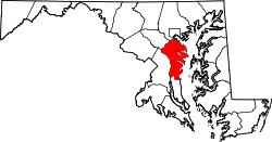
Anne Arundel County Maryland Incorporated and Unincorporated areas Herald Harbor Highlighted.svg
Location of Herald Harbor, Maryland
Coordinates: 39°3′5″N76°34′30″W / 39.05139°N 76.57500°W / 39.05139; -76.57500 Coordinates: 39°3′5″N76°34′30″W / 39.05139°N 76.57500°W / 39.05139; -76.57500
CountryFlag of the United States.svg United States
State Flag of Maryland.svg  Maryland
County Flag of Anne Arundel County, Maryland.png Anne Arundel
Area
[1]
  Total2.46 sq mi (6.36 km2)
  Land1.68 sq mi (4.35 km2)
  Water0.78 sq mi (2.01 km2)
Elevation
52 ft (16 m)
Population
 (2020)
  Total2,869
  Density1,708.76/sq mi (659.84/km2)
Time zone UTC−5 (Eastern (EST))
  Summer (DST) UTC−4 (EDT)
FIPS code 24-38025
GNIS feature ID0590448

Herald Harbor is a census-designated place and an unincorporated community in Anne Arundel County, Maryland, United States. As of the 2010 census, the population was 2,603. [2] It is a quiet residential area with a scenic view of the Severn River and is near the community of Crownsville and Interstate 97. Herald Harbor is known for its area immediately along the Severn River known as Long Point on the Severn, [3] a fairly affluent neighborhood composed mainly of retired and wealthy land owners.
Contents

Geography

Herald Harbor is located at 39°3′5″N76°34′30″W / 39.05139°N 76.57500°W / 39.05139; -76.57500 (39.051260, 76.574960). [4]

According to the United States Census Bureau, the CDP has a total area of 2.4 square miles (6.3 km2), of which 1.7 square miles (4.4 km2) is land and 0.77 square miles (2.0 km2), or 31.31%, is water, consisting of the tidal Severn River. [2]

The name "Herald Harbor" is originally derived from a Washington, D.C. newspaper, the Washington Herald , which promoted its subscriptions by giving away small plots of land in the area for summer homes.

Demographics

Historical population
CensusPop.
2020 2,869
U.S. Decennial Census [5]

As of the census [6] of 2000, there were 2,313 people, 941 households, and 641 families residing in the CDP. The population density was 1,373.0 people per square mile (531.6/km2). There were 1,022 housing units at an average density of 606.6/sq mi (234.9/km2). The racial makeup of the CDP was 96.97% White, 0.65% African American, 0.30% Native American, 0.82% Asian, 0.04% Pacific Islander, 0.17% from other races, and 1.04% from two or more races. Hispanic or Latino of any race were 1.25% of the population.

There were 941 households, out of which 28.6% had children under the age of 18 living with them, 58.8% were married couples living together, 6.3% had a female householder with no husband present, and 31.8% were non-families. 22.0% of all households were made up of individuals, and 4.3% had someone living alone who was 65 years of age or older. The average household size was 2.46 and the average family size was 2.90.

In the CDP, the population was spread out, with 21.1% under the age of 18, 6.1% from 18 to 24, 34.5% from 25 to 44, 30.3% from 45 to 64, and 8.0% who were 65 years of age or older. The median age was 39 years. For every 100 females, there were 105.6 males. For every 100 females age 18 and over, there were 101.8 males.

The median income for a household in the CDP was $73,893, and the median income for a family was $83,812. Males had a median income of $55,000 versus $28,684 for females. The per capita income for the CDP was $34,189. About 4.1% of families and 5.9% of the population were below the poverty line, including 10.3% of those under age 18 and none of those age 65 or over.

Related Research Articles

West Carson, California Place in California, United States

West Carson is an unincorporated community in Los Angeles County, California. The population was 21,699 at the 2010 census, up from 21,138 at the 2000 census. For statistical purposes, the United States Census Bureau has defined West Carson as a census-designated place (CDP).

Burnt Store Marina, Florida Census-designated place in Florida, United States

Burnt Store Marina is an unincorporated community and census-designated place (CDP) in Lee County, Florida, United States. The population was 1,793 at the 2010 census, up from 1,271 at the 2000 census. It is part of the Cape Coral-Fort Myers, Florida Metropolitan Statistical Area.

Page Park, Florida Census-designated place in Florida, United States

Page Park is a census-designated place (CDP) in Lee County, Florida, United States. The population was 514 at the 2010 census. It is part of the Cape Coral-Fort Myers, Florida Metropolitan Statistical Area.

Crownsville, Maryland Census-designated place in Maryland, United States

Crownsville is a census-designated place (CDP) in Anne Arundel County, Maryland, United States. The population was 1,757 at the 2010 census. It hosts the Anne Arundel County Fair each September, as well as the annual Maryland Renaissance Festival for several summer weekends. A state psychiatric hospital was formerly in Crownsville. The area offers waterfront scenery and easy access to urban metropolitan areas and culture.

Riviera Beach, Maryland Census-designated place in Maryland, United States

Riviera Beach is a census-designated place and a neighborhood within Pasadena in Anne Arundel County, Maryland, United States. The population was 12,677 at the 2010 U.S. census.

Severn, Maryland Census-designated place in Maryland, United States

Severn is a census-designated place (CDP) in Anne Arundel County, Maryland, United States. The population was 44,231 at the 2010 census, a 26% increase from its population of 35,076 in 2000. The zip code is 21144.

Severna Park, Maryland Census-designated place in Maryland, United States

Severna Park is a census-designated place (CDP) in Anne Arundel County, Maryland, United States. Severna Park is part of the Baltimore-Washington Metropolitan Area, and is located approximately 8 miles (13 km) north of Annapolis, 17 miles (27 km) south of Baltimore and 39 miles (63 km) east of Washington. Severna Park's population was 37,634 at the 2010 census.

South Gate, Maryland Former census-designated place in Maryland, United States

South Gate was a census-designated place (CDP) in Anne Arundel County, Maryland, United States, for the 2000 census, at which time its population was 28,672. It was added primarily to the Glen Burnie CDP for the 2010 census.

Carney, Maryland Census-designated place in Maryland, United States

Carney is an unincorporated community and census-designated place in Baltimore County, Maryland, United States. The population was 29,941 at the 2010 census.

Edgemere, Maryland Census-designated place in Maryland, United States

Edgemere is an unincorporated community and census-designated place in Baltimore County, Maryland, United States. The population was 8,669 at the 2010 census. Founded in 1899 as Edgemere being renamed from previous name "Fitzell". Meeting held at the Fitzell Farm which was situated where the old Rheem plant was located.

Maugansville, Maryland CDP in Maryland, United States

Maugansville is a census-designated place (CDP) in Washington County, Maryland, United States. The population was 2,295 at the 2000 census.

Pinehurst, Massachusetts Census-designated place in Massachusetts, United States

Pinehurst is an unincorporated village and census-designated place (CDP) in the town of Billerica, Middlesex County, Massachusetts, United States. The population was 7,152 at the 2010 census. It is located in the southeastern part of town along Massachusetts Route 3A between the Shawsheen River and the Burlington town line.

Harbor Hills, Ohio Census-designated place in Ohio, United States

Harbor Hills is a census-designated place (CDP) in southern Licking County, Ohio, United States. The population was 1,509 at the 2010 census, up from 1,303 at the 2000 census.

Pennville, Pennsylvania CDP in Pennsylvania, United States

Pennville is a census-designated place (CDP) in York County, Pennsylvania, United States. The population was 1,947 at the 2010 census.

Spry, Pennsylvania CDP in Pennsylvania, United States

Spry is a census-designated place (CDP) in York County, Pennsylvania, United States. The population was 4,891 at the 2010 census.

Lake Tansi Village is a resort community in Cumberland County, Tennessee, United States, recognized by the U.S. Census as a census-designated place (CDP). The population was 5,629 at the 2020 census.

Windemere, Texas Former CDP in Texas, United States

Windemere is a former census-designated place (CDP) in Travis County, Texas, United States. The population was 1,037 at the 2010 census. It has since largely been annexed by the city of Pflugerville.

Ocean City, Washington Census-designated place in Washington, United States

Ocean City is a census-designated place (CDP) in Grays Harbor County, Washington, United States. The population was 200 at the 2010 census.

Oakhurst, Oklahoma Census-designated place in Oklahoma, United States

Oakhurst is an unincorporated community and census-designated place (CDP) in Creek and Tulsa counties in the U.S. state of Oklahoma. The population was 2,185 at the 2010 census, a loss of 20 percent from 2,731 at the 2000 census.

Greenwich (CDP), Connecticut Census-designated place in Connecticut, United States

Greenwich is a census-designated place (CDP) in Fairfield County, Connecticut, United States. It is one of several CDPs within the town of Greenwich and corresponds to the historic municipal center of the town and surrounding residential and commercial areas. As of the 2010 census, the population of the Greenwich CDP was 12,942, out of 61,171 in the entire town.

References

  1. "2020 U.S. Gazetteer Files". United States Census Bureau. Retrieved April 26, 2022.
  2. 1 2 "Geographic Identifiers: 2010 Demographic Profile Data (G001): Herald Harbor CDP, Maryland". U.S. Census Bureau, American Factfinder. Archived from the original on February 12, 2020. Retrieved May 30, 2013.
  3. "Long Point on the Severn Website". Long Point on the Severn Civic Association. Archived from the original on October 29, 2013. Retrieved October 26, 2013.
  4. "US Gazetteer files: 2010, 2000, and 1990". United States Census Bureau. 2011-02-12. Retrieved 2011-04-23.
  5. "Census of Population and Housing". Census.gov. Retrieved June 4, 2016.
  6. "U.S. Census website". United States Census Bureau . Retrieved 2008-01-31.