
Anne Arundel County, also notated as AA or A.A. County, is located in the U.S. state of Maryland. As of the 2020 United States census, its population was 588,261, an increase of just under 10% since 2010. Its county seat is Annapolis, which is also the capital of the state. The county is named for Anne Arundell, Lady Baltimore, a member of the ancient family of Arundells in Cornwall, England, and the wife of Cecilius Calvert, 2nd Baron Baltimore (1605–1675), founder and first lord proprietor of the colony Province of Maryland. The county is part of the Central Maryland region of the state. Anne Arundel County is included in the Washington–Baltimore–Arlington combined statistical area.

Long Neck is a census-designated place (CDP) in Sussex County, Delaware, United States. The population was 1,980 at the 2010 census. Long Neck was the only census-designated place in Sussex County until Lincoln was added in the 2020 United States census. It is part of the Salisbury, Maryland-Delaware Metropolitan Statistical Area.
Hillsmere Shores was a census-designated place (CDP) in Anne Arundel County, Maryland, United States. It is a suburb of Annapolis. The population was 2,977 at the 2000 census. It was included in the Annapolis Neck CDP at the 2010 census. Built in phases, beginning in 1960, the community has been home to The Key School, a non-sectarian private school, since the 1960s.

Linthicum is a census-designated place (CDP) and unincorporated community in Anne Arundel County, Maryland, United States. The population was 10,324 at the 2010 census. It is located directly north of Baltimore–Washington International Thurgood Marshall Airport (BWI).

Mayo is a census-designated place (CDP) in Anne Arundel County, Maryland, United States. The population was 8,298 in the 2010 census. The Mayo CDP of 2010 includes all of the area that used to be counted as the Selby-on-the-Bay CDP. The beach in Mayo used to be a popular weekend resort.

Parole, a suburb of Annapolis, is a census-designated place (CDP) in Anne Arundel County, Maryland, United States. The population was 15,922 at the 2010 census. It has several major roads intersect at the western edge of the state capital, Annapolis, and it contains the Annapolis Mall, a number of other large shopping centers, and the Anne Arundel Medical Center. It is generally considered to be part of Annapolis, rather than a separate town.

Pasadena is a census-designated place (CDP) in Anne Arundel County, Maryland, United States. The population was 24,287 at the 2010 census.

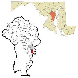
Severn is a census-designated place (CDP) in Anne Arundel County, Maryland, United States. According to the 2020 U.S. census, the population of Severn is 57,118, a 22.6% increase from 44,231 in 2010. The zip code is 21144.

Severna Park is a census-designated place (CDP) in Anne Arundel County, Maryland, United States. Severna Park is part of the Baltimore-Washington Metropolitan Area, and is located approximately 8 miles (13 km) north of Annapolis, 17 miles (27 km) south of Baltimore and 39 miles (63 km) east of Washington, D.C. Severna Park's population was 39,933 at the 2020 census.

Shady Side is a census-designated place (CDP) in Anne Arundel County, Maryland, United States. The population was 5,803 at the 2010 census.
Seabrook is an unincorporated community and census-designated place (CDP) in Prince George's County, Maryland, United States, located approximately 12 miles (19 km) east of Washington, D.C. Per the 2020 census, the population was 19,627. Prior to 2010, Seabrook was part of the Lanham-Seabrook census-designated place.

Baltimore Highlands is a census-designated place (CDP) in Baltimore County, Maryland, United States, directly south of the city of Baltimore. The population was 7,019 at the 2010 census. At the 2000 census and earlier, the area was delineated as part of the Lansdowne-Baltimore Highlands CDP.
Gambrills refers to two neighboring places in Anne Arundel County, Maryland, United States, located in the Annapolis metro area: the unincorporated community of Gambrills, and the Gambrills census-designated place (CDP). The area was named after Augustine Gambrill, plantation owner. The CDP covers an expansive range that falls within the communities of Crofton, Waugh Chapel, and Odenton. It also borders Davidsonville, Crownsville, Millersville, and Prince George's County, Maryland.
Lisbon is a census-designated place located in western Howard County in the state of Maryland, United States, located roughly between Baltimore and Frederick and north of Washington, D.C. It is contained in an area of roughly one square mile. Lisbon is located along Interstate 70 and Maryland Route 144 and is home to the first roundabout in Maryland. It first appeared as a CDP in the 2020 Census with a population of 282.

Galesville is an unincorporated town and census-designated place (CDP) in Anne Arundel County, Maryland, United States. As of the 2010 census, it had a population of 685.
Bishopville [bɪʃɪpvɪl] is an unincorporated community and census-designated place 10 miles (16 km) north of Berlin in Worcester County, Maryland, United States. The community is just south of the Delaware state line. It is part of the Salisbury, Maryland-Delaware Metropolitan Statistical Area. As of the 2010 census, Bishopville had a population of 531.
West Denton is an unincorporated community and census-designated place (CDP) in Caroline County, Maryland, United States. As of the 2010 census it had a population of 52.
Friendship is an unincorporated community and census-designated place (CDP) in Anne Arundel County, Maryland, United States. As of the 2010 census, its population was 447.
Edgewater is a census-designated place (CDP) in Anne Arundel County, Maryland, United States. The population was 9,023 at the 2010 census.


