West River, Maryland

Last updated
West River, Maryland
USA Maryland location map.svg
Red pog.svg
West River, Maryland
Location within the state of Maryland
Usa edcp location map.svg
Red pog.svg
West River, Maryland
West River, Maryland (the United States)
Coordinates: 38°51′01″N76°35′46″W / 38.85028°N 76.59611°W / 38.85028; -76.59611 Coordinates: 38°51′01″N76°35′46″W / 38.85028°N 76.59611°W / 38.85028; -76.59611
Country Flag of the United States.svg United States
State Flag of Maryland.svg  Maryland
County Flag of Anne Arundel County, Maryland.png Anne Arundel
Elevation
82 ft (25 m)
Time zone UTC-5 (Eastern (EST))
  Summer (DST) UTC-4 (EDT)
ZIP code
20778 [1]
Area code(s) 410,443 and 667

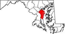
West River is an unincorporated community in Anne Arundel County, Maryland, United States. [2]

Notable person

Related Research Articles

<span class="mw-page-title-main">Colorado</span> U.S. state

Colorado is a state in the Mountain West subregion of the Western United States. It encompasses most of the Southern Rocky Mountains, as well as the northeastern portion of the Colorado Plateau and the western edge of the Great Plains. Colorado is the eighth most extensive and 21st most populous U.S. state. The 2020 United States census enumerated the population of Colorado at 5,773,714, an increase of 14.80% since the 2010 United States census.

<span class="mw-page-title-main">Europe</span> Continent

Europe is a large peninsula conventionally considered a continent in its own right because of its great physical size and the weight of its history and traditions. Europe is also considered a subcontinent of Eurasia and it is located entirely in the Northern Hemisphere and mostly in the Eastern Hemisphere. Comprising the westernmost peninsulas of Eurasia, it shares the continental landmass of Afro-Eurasia with both Africa and Asia. It is bordered by the Arctic Ocean to the north, the Atlantic Ocean to the west, the Mediterranean Sea to the south and Asia to the east. Europe is commonly considered to be separated from Asia by the watershed of the Ural Mountains, the Ural River, the Caspian Sea, the Greater Caucasus, the Black Sea and the waterways of the Turkish Straits.

<span class="mw-page-title-main">Mississippi River</span> Major river in the United States

The Mississippi River is the second-longest river and chief river of the second-largest drainage system in North America, second only to the Hudson Bay drainage system. From its traditional source of Lake Itasca in northern Minnesota, it flows generally south for 2,340 miles (3,770 km) to the Mississippi River Delta in the Gulf of Mexico. With its many tributaries, the Mississippi's watershed drains all or parts of 32 U.S. states and two Canadian provinces between the Rocky and Appalachian mountains. The main stem is entirely within the United States; the total drainage basin is 1,151,000 sq mi (2,980,000 km2), of which only about one percent is in Canada. The Mississippi ranks as the thirteenth-largest river by discharge in the world. The river either borders or passes through the states of Minnesota, Wisconsin, Iowa, Illinois, Missouri, Kentucky, Tennessee, Arkansas, Mississippi, and Louisiana.

<span class="mw-page-title-main">Nigeria</span> Country in West Africa

Nigeria, officially the Federal Republic of Nigeria, is a country in West Africa. It is situated between the Sahel to the north and the Gulf of Guinea to the south in the Atlantic Ocean. It covers an area of 923,769 square kilometres (356,669 sq mi), and with a population of over 225 million, it is the most populous country in Africa, and the world's sixth-most populous country. Nigeria borders Niger in the north, Chad in the northeast, Cameroon in the east, and Benin in the west. Nigeria is a federal republic comprising 36 states and the Federal Capital Territory, where the capital, Abuja, is located. The largest city in Nigeria is Lagos, one of the largest metropolitan areas in the world and the second-largest in Africa.

<span class="mw-page-title-main">Nebraska</span> U.S. state

Nebraska is a state in the Midwestern region of the United States. It is bordered by South Dakota to the north; Iowa to the east and Missouri to the southeast, both across the Missouri River; Kansas to the south; Colorado to the southwest; and Wyoming to the west. It is the only triply landlocked U.S. state.

<span class="mw-page-title-main">Ohio</span> U.S. state

Ohio is a state in the Midwestern region of the United States. Of the fifty U.S. states, it is the 34th-largest by area, and with a population of nearly 11.8 million, is the seventh-most populous and tenth-most densely populated. The state's capital and largest city is Columbus, with the Columbus metro area, Greater Cincinnati, and Greater Cleveland being the largest metropolitan areas. Ohio is bordered by Lake Erie to the north, Pennsylvania to the east, West Virginia to the southeast, Kentucky to the southwest, Indiana to the west, and Michigan to the northwest. Ohio is historically known as the "Buckeye State" after its Ohio buckeye trees, and Ohioans are also known as "Buckeyes". Its state flag is the only non-rectangular flag of all the U.S. states.

<span class="mw-page-title-main">Rio Grande</span> Major river forming part of the US–Mexico border

The Rio Grande, known in Mexico as the Río Bravo del Norte or simply the Río Bravo, is one of the principal rivers in the southwestern United States and in northern Mexico. The length of the Rio Grande is 1,896 miles (3,051 km). It originates in south-central Colorado, in the United States, and flows to the Gulf of Mexico. The Rio Grande drainage basin (watershed) has an area of 182,200 square miles (472,000 km2); however, the endorheic basins that are adjacent to and within the greater drainage basin of the Rio Grande increase the total drainage-basin area to 336,000 square miles (870,000 km2).

<span class="mw-page-title-main">Grand Canyon</span> Steep-sided canyon carved by the Colorado River in Arizona, United States

The Grand Canyon is a steep-sided canyon carved by the Colorado River in Arizona, United States. The Grand Canyon is 277 miles (446 km) long, up to 18 miles (29 km) wide and attains a depth of over a mile.

<span class="mw-page-title-main">West Point, New York</span> CDP in New York, United States

West Point is the oldest continuously occupied military post in the United States. Located on the Hudson River in New York, West Point was identified by General George Washington as the most important strategic position in America during the American Revolution. Until January 1778, West Point was not occupied by the military. On January 27, 1778, Brigadier General Samuel Holden Parsons and his brigade crossed the ice on the Hudson River and climbed to the plain on West Point and from that day to the present, West Point has been occupied by the United States Army. It comprises approximately 16,000 acres (6,500 ha) including the campus of the United States Military Academy, which is commonly called "West Point".

<span class="mw-page-title-main">Dnieper</span> Longest river of Ukraine and Belarus

The Dnieper or Dnipro is one of the major transboundary rivers of Europe, rising in the Valdai Hills near Smolensk, Russia, before flowing through Belarus and Ukraine to the Black Sea. It is the longest river of Ukraine and Belarus and the fourth-longest river in Europe, after the Volga, Danube, and Ural rivers. It is approximately 2,200 km (1,400 mi) long, with a drainage basin of 504,000 square kilometres (195,000 sq mi).

<span class="mw-page-title-main">West Oxfordshire</span> Non-metropolitan district in England

West Oxfordshire is a local government district in northwest Oxfordshire, England, including towns such as Woodstock, Burford, Chipping Norton, Charlbury, Carterton and Witney, where the council is based.

<span class="mw-page-title-main">Sacramento River Cats</span> Minor league baseball team

The Sacramento River Cats are a Minor League Baseball team of the Pacific Coast League (PCL) and are the Triple-A affiliate of the San Francisco Giants. Prior to 2015, the River Cats were the Triple-A affiliate of the Oakland Athletics for 15 years. They are based in West Sacramento, California, and play their home games at Sutter Health Park which opened in 2000 and was known as Raley Field through 2019.

<span class="mw-page-title-main">Hooghly River</span> Distributary of the Ganges River in India

The Hooghly River or the 'Bhāgirathi-Hooghly', called the Ganga or the Kati-Ganga in mythological texts, is the eastern distributary of the Ganges River in West Bengal, India, rising close to Giria in Murshidabad. The main distributary of the Ganges then flows into Bangladesh as the Padma. Today there is a man-made canal called the Farakka Feeder Canal connecting the Ganges to the Bhagirathi.

<span class="mw-page-title-main">River Leven, North Yorkshire</span> River in North Yorkshire, England

The River Leven in North Yorkshire, England is a tributary of the River Tees. It rises on Warren Moor, part of Kildale Moor, in the North York Moors and flows to the north of the moors to join the River Tees at Yarm.

<span class="mw-page-title-main">North West River</span> Town in Newfoundland and Labrador, Canada

North West River is a small town located in central Labrador. Established in 1743 as a trading post by French Fur Trader Louis Fornel, the community later went on to become a hub for the Hudson's Bay Company and home to a hospital and school serving the needs of coastal Labrador. North West River is the oldest modern settlement in Labrador.

This timeline is a chronology of significant events in the history of the U.S. State of Colorado and the historical area now occupied by the state.

<span class="mw-page-title-main">Buffalo River Dene Nation</span> First Nations band in Saskatchewan, Canada

The Buffalo River Dene Nation is a Dene First Nations band government in Saskatchewan, Canada. The band's main community, Dillon, is located on the western shore of Peter Pond Lake at the mouth of the Dillon River, and is accessed by Highway 925 from Highway 155.

<span class="mw-page-title-main">Julián Álvarez (footballer)</span> Argentine footballer (born 2000)

Julián Álvarez, nicknamed "La Araña", is an Argentine professional footballer who plays as a forward for Premier League club Manchester City and the Argentina national team. As a forward, his main position is as a striker but he can also operate as a winger.

<span class="mw-page-title-main">North Branch Potomac River</span> Tributary of the Potomac River

The North Branch Potomac River flows from Fairfax Stone in West Virginia to its confluence with the South Branch Potomac River near Green Spring, West Virginia, where it turns into the Potomac River proper.

References

  1. "West River ZIP Code". zipdatamaps.com. 2022. Retrieved November 18, 2022.
  2. "Geographic Names Information System". West River (Populated Place). U.S. Geological Survey. 2009-01-29.