Lothian, Maryland

Last updated
Lothian, Maryland
USA Maryland location map.svg
Red pog.svg
Lothian, Maryland
Location within the state of Maryland
Usa edcp location map.svg
Red pog.svg
Lothian, Maryland
Lothian, Maryland (the United States)
Coordinates: 38°49′54″N76°36′41″W / 38.83167°N 76.61139°W / 38.83167; -76.61139 Coordinates: 38°49′54″N76°36′41″W / 38.83167°N 76.61139°W / 38.83167; -76.61139
Country Flag of the United States.svg United States
State Flag of Maryland.svg  Maryland
County Flag of Anne Arundel County, Maryland.png Anne Arundel
Time zone UTC-5 (Eastern (EST))
  Summer (DST) UTC-4 (EDT)
ZIP codes
20711

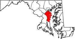
Lothian is an unincorporated community in Anne Arundel County, Maryland, United States., [1] 12 miles southwest of Annapolis, 24 miles east of Washington and 31 miles south of Baltimore. As of the 2010 Census, the population was 6,643 people.

Public Schools: Lothian Elementary, Southern Middle, and Southern Senior.

Members of Congress: U.S. Senators Chris Van Hollen and Ben Cardin; U.S. Representative Steny Hoyer (D-Md.-5th District).

State Representatives: State Representative Robert A. Costa (Maryland House of Delegates District 33B) (see Map of District 33B); Md State Senator Edward R. Reilly.

Related Research Articles

Cambridge, Maryland City in Maryland, United States

Cambridge is a city in Dorchester County, Maryland, United States. The population was 12,326 at the 2010 census. It is the county seat of Dorchester County and the county's largest municipality. Cambridge is the fourth most populous city in Maryland's Eastern Shore region, after Salisbury, Elkton and Easton.

Fort Washington, Maryland Census-designated place in Maryland

Fort Washington is an unincorporated area and census-designated place in Prince George's County, Maryland, United States. It borders the capital of the United States of America, Washington, D.C., situated just south of the downtown district. As of the 2010 census it had a population of 23,717. Fort Washington is a prosperous community with an African American majority population. The Fort Washington community is located west of Maryland Route 210, with some additional area to the east of the highway.

U.S. Route 340 is a spur route of US 40, and runs from Greenville, Virginia to Frederick, Maryland. In Virginia, it runs north–south, parallel and east of US 11, from US 11 north of Greenville via Waynesboro, Grottoes, Elkton, Luray, Front Royal, and Berryville to the West Virginia state line. A short separate piece crosses northern Loudoun County on its way from West Virginia to Maryland.

Maryland Route 4

Maryland Route 4 is a state highway in the U.S. state of Maryland. The highway runs 64.85 miles (104.37 km) from MD 5 in Leonardtown north to Southern Avenue in Suitland at the District of Columbia boundary, beyond which the highway continues into Washington as Pennsylvania Avenue. MD 4 is a four- to six-lane highway that connects Washington and communities around the Capital Beltway with southern Prince George's County with southwestern Anne Arundel County. The highway is the primary highway for the length of Calvert County, during most of which the route runs concurrently with MD 2. MD 4 also connects Calvert and St. Mary's counties via the Governor Thomas Johnson Bridge across the Patuxent River. The highway connects the Southern Maryland county seats of Leonardtown, Prince Frederick, and Upper Marlboro.

Maryland Route 537

Maryland Route 537 is a collection of unsigned state highways in the U.S. state of Maryland. These two existing highways and two former sections of state highway are segments of old alignment of U.S. Route 213, which is now MD 213, in Chesapeake City in southern Cecil County. Some of the roads that became segments of MD 537 were constructed in the mid-1910s as part of the original state road between Elkton and Cecilton. Other portions of MD 537 were part of the approach roads to a bridge across the Chesapeake & Delaware Canal that was built in the mid-1920s and destroyed in 1942. After the modern Chesapeake City Bridge and its approach roads were completed in 1949, US 213 was moved to the new bridge and approach roads and MD 537 was assigned to the bypassed sections of US 213. Much of MD 537 outside of Chesapeake City was transferred to county maintenance in the late 1950s. In 2015, the remaining section of MD 537 north of the canal was turned over to municipal maintenance.

Maryland Democratic Party

The Maryland Democratic Party is the affiliate of the Democratic Party in the state of Maryland, headquartered in Annapolis. The current state party chair is Yvette Lewis.

Maryland Route 322 Highway in Maryland

Maryland Route 322 (MD 322) is a state highway in the U.S. state of Maryland. Known as Easton Parkway, the highway runs 5.12 miles (8.24 km) on the west side of Easton between two junctions with U.S. Route 50 (US 50). MD 322 serves as a bypass of downtown Easton for traffic between US 50 and highways to western Talbot County, including MD 33 toward Saint Michaels and Tilghman Island and MD 333 toward Oxford. Easton Parkway was constructed in the mid to late 1960s. The state highway was originally designated as part of MD 33; MD 322 became the sole designation on the bypass in 1978.

Maryland Route 565 Highway in Maryland

Maryland Route 565 is a collection of state highways in the U.S. state of Maryland. These highways are sections of old alignment of U.S. Route 213, the predecessor route to US 50, between Trappe and Easton. The two mainline sections of MD 565 run from Trappe to US 50 south of Easton and within the southern part of Easton. MD 565 was assigned to the Trappe–Easton section in the early 1940s when US 213 was moved to a new alignment between Trappe and Peach Blossom Creek in southern Talbot County. MD 565A was designated in the late 1950s in the southern part of Easton and extended north of the downtown area in the mid-1960s. Portions of MD 565 were returned to municipal maintenance in Easton and Trappe in the mid-1980s and late 1990s.

1969 Maryland special gubernatorial election

The Maryland special gubernatorial election, 1969 was not a direct election, but a vote in the Maryland General Assembly to determine who would assume the governorship of Maryland after Spiro Agnew's resignation, following his election to the U.S. vice presidency.

Maryland Route 408

Maryland Route 408 is a state highway in the U.S. state of Maryland. Known as Mount Zion-Marlboro Road, the highway runs 5.62 miles (9.04 km) from MD 4 at Waysons Corner east to MD 2 and MD 422 in Lothian. MD 408 is the old alignment of MD 4 in southern Anne Arundel County. The highway was constructed in the late 1910s and became the easternmost part of MD 4 in 1927. The highway received its present designation in the mid-1960s when MD 4 was rerouted south into Calvert County. MD 408's western end was relocated when MD 4 was upgraded to a freeway through Waysons Corner in the early 1990s. MD 408 was also applied to the old sections of MD 4 between Andrews Air Force Base and Upper Marlboro in Prince George's County. The number was assigned after the MD 4 freeway was completed in the mid-1960s. The Prince George's County portions of MD 408 were transferred to county maintenance in the late 1970s except the section through Upper Marlboro, which became MD 725.

Maryland Route 259

Maryland Route 259 is a state highway in the U.S. state of Maryland. Known as Greenock Road, the highway runs 2.67 miles (4.30 km) from MD 794 in Bristol north to MD 408 near Lothian. MD 259 was constructed in the late 1920s and early 1930s.

Maryland Route 422

Maryland Route 422 is a state highway in the U.S. state of Maryland. Known as Bayard Road, the highway runs 3.04 miles (4.89 km) from Polling House Road near Lothian east to MD 2 and MD 408 at Lothian in southern Anne Arundel County. MD 422 was constructed in the late 1920s.

Maryland Route 778

Maryland Route 778 is a state highway in the U.S. state of Maryland. Known as Old Solomons Island Road, the state highway runs 2.12 miles (3.41 km) from MD 2 near Owings north to MD 261 at Friendship. MD 778 and its unsigned auxiliary routes are segments of the old alignment of MD 2 in far northern Calvert County and southern Anne Arundel County. MD 2 was originally constructed as one of the original state roads in the early to mid-1910s. The state highway from Edgewater south to Owings was reconstructed in stages from the early 1950s to the mid-1960s, when the Owings–Friendship portion of MD 2 was relocated. As portions of the old MD 2 were bypassed, they were designated segments of MD 778.

2012 United States Senate election in Maryland

The 2012 United States Senate election in Maryland took place on November 6, 2012, concurrently with the 2012 U.S. presidential election as well as other elections to the United States Senate, House of Representatives, and various state and local elections. Incumbent Democratic U.S. Senator Ben Cardin won re-election to a second term, defeating Republican nominee Dan Bongino and independent Rob Sobhani.

2012 United States House of Representatives elections in Maryland

The 2012 United States House of Representatives elections in Maryland were held on Tuesday, November 6, 2012 to elect the eight U.S. Representatives from the state of Maryland, one from each of the state's eight congressional districts. The elections coincided with the elections of other federal and state offices, including the quadrennial presidential election and an election to the U.S. Senate.

2016 United States House of Representatives elections in Maryland

The 2016 United States House of Representatives elections in Maryland were held on November 8, 2016, to elect the eight U.S. Representatives from the state of Maryland, one from each of the state's eight congressional districts. The elections coincided with the 2016 U.S. presidential election, as well as other elections to the House of Representatives, elections to the United States Senate and various state and local elections. The primaries were held on April 26.

2020 United States House of Representatives elections in Maryland Upcoming House elections in Maryland

The 2020 United States House of Representatives elections in Maryland will be held on November 3, 2020, to elect the eight U.S. Representatives from the state of Maryland, one from each of the state's eight congressional districts. The elections will coincide with the 2020 U.S. presidential election, as well as other elections to the House of Representatives, elections to the United States Senate and various state and local elections. On March 17, 2020, Governor Larry Hogan announced that the primary election would be postponed from April 28 to June 2 due to coronavirus concerns. On March 26, the Maryland Board of Elections met to consider whether in-person voting should be used for June's primary, and recommended that voting in June be mail-in only.

References

  1. "Geographic Names Information System". Lothian (Populated Place). U.S. Geological Survey. 2009-01-29.