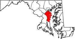
South River, Maryland

Last updated
South River
Unincorporated community
USA Maryland location map.svg
Red pog.svg
South River
Location within the state of Maryland
Usa edcp location map.svg
Red pog.svg
South River
South River (the US)
Coordinates: 38°54′11″N76°33′38″W / 38.90306°N 76.56056°W / 38.90306; -76.56056 Coordinates: 38°54′11″N76°33′38″W / 38.90306°N 76.56056°W / 38.90306; -76.56056
Country Flag of the United States.svg United States
State Flag of Maryland.svg  Maryland
County Flag of Anne Arundel County, Maryland.png Anne Arundel
Time zone Eastern (EST) (UTC-5)
  Summer (DST) EDT (UTC-4)

South River is an unincorporated community in Anne Arundel County, Maryland, United States. [1] South River Club was listed on the National Register of Historic Places in 1969. [2]

Unincorporated area Region of land not governed by own local government

In law, an unincorporated area is a region of land that is not governed by a local municipal corporation; similarly an unincorporated community is a settlement that is not governed by its own local municipal corporation, but rather is administered as part of larger administrative divisions, such as a township, parish, borough, county, city, canton, state, province or country. Occasionally, municipalities dissolve or disincorporate, which may happen if they become fiscally insolvent, and services become the responsibility of a higher administration. Widespread unincorporated communities and areas are a distinguishing feature of the United States and Canada. In most other countries of the world, there are either no unincorporated areas at all, or these are very rare; typically remote, outlying, sparsely populated or uninhabited areas.

Anne Arundel County, Maryland county in Maryland, United States

Anne Arundel County, also notated as AA or A.A. County, is a county located in the U.S. state of Maryland. As of the 2010 United States Census, its population was 537,656, a population increase of just under 10% since 2000. Its county seat is Annapolis, which is also the capital of the state. The county is named for Lady Anne Arundell (1615–1649), a member of the ancient family of Arundells in Cornwall, England, and the wife of Cecilius Calvert, 2nd Baron Baltimore (1605–1675), founder and first Lord Proprietor of the colony Province of Maryland.

Maryland State of the United States of America

Maryland is a state in the Mid-Atlantic region of the United States, bordering Virginia, West Virginia, and the District of Columbia to its south and west; Pennsylvania to its north; and Delaware to its east. The state's largest city is Baltimore, and its capital is Annapolis. Among its occasional nicknames are Old Line State, the Free State, and the Chesapeake Bay State. It is named after the English queen Henrietta Maria, known in England as Queen Mary.

See also

Related Research Articles

Watson Mill Bridge State Park

Watson Mill Bridge State Park is a 1,018 acre (4.12 km²) Georgia state park located near Comer and Carlton on the South Fork of the Broad River. The park is named for the Watson Mill Bridge, the longest original-site covered bridge in Georgia, which spans 229 feet across the South Fork River. The site is listed on the National Register of Historic Places as the Watson Mill Covered Bridge and Mill Historic District. The bridge, being more than 100 years old, is supported by a town lattice truss system held firmly together with wooden pins. Georgia once had over 200 covered bridges, but only 20 now remain. The park also offers a scenic nature trail and a new hiking/horse trail that winds through the thick forests and along the rivers edge.

Cascade River State Park place in Minnesota listed on National Register of Historic Places

Cascade River State Park is a state park near the northeastern tip of Minnesota, USA, on the north shore of Lake Superior. The park is in a rocky and rugged location, and has many different types of wildlife.

National Register of Historic Places listings in Arkansas Wikimedia list article

This is a list of properties and historic districts in Arkansas that are listed on the National Register of Historic Places. There are more than 2,600 listings in the state, including at least 8 listings in each of Arkansas's 75 counties.

National Register of Historic Places listings in Pennsylvania Wikimedia list article

This is a list of properties and districts listed on the National Register of Historic Places in Pennsylvania. As of 2015, there are over 3,000 listed sites in Pennsylvania. Sixty-six of the 67 counties in Pennsylvania have listings on the National Register; Cameron County is the only county without any sites listed.

National Register of Historic Places listings in South Carolina Wikimedia list article

This is a list of the properties and historic districts in each of the 46 counties of South Carolina that are designated National Register of Historic Places.

National Register of Historic Places listings in Fairfield County, Connecticut Wikimedia list article

This is intended to be a complete list of the properties and districts on the National Register of Historic Places in Fairfield County, Connecticut, United States. The locations of National Register properties and districts for which the latitude and longitude coordinates are included below, may be seen in an online map.

National Register of Historic Places listings in Litchfield County, Connecticut Wikimedia list article

This is a list of the National Register of Historic Places listings in Litchfield County, Connecticut.

Fort Ridgely State Park

Fort Ridgely State Park is a state park of Minnesota, USA, on the Minnesota River south of Fairfax. It preserves Fort Ridgely, site of the Battle of Fort Ridgely during the Dakota War of 1862. It is the only Minnesota state park with a 9-hole golf course, which overlooks the Minnesota River and goes along Fort Ridgely Creek.

The following is a list of Registered Historic Places in Midland County, Michigan.

The following is a list of Registered Historic Places in Ottawa County, Michigan.

National Register of Historic Places listings in Charleston County, South Carolina Wikimedia list article

This is a list of the National Register of Historic Places listings in Charleston County, South Carolina.

List of Registered Historic Places in Fall River, Massachusetts, which has been transferred from and is an integral part of National Register of Historic Places listings in Bristol County, Massachusetts

National Register of Historic Places listings in Botetourt County, Virginia Wikimedia list article

This is a list of the National Register of Historic Places listings in Botetourt County, Virginia.

National Register of Historic Places listings in Halifax County, Virginia Wikimedia list article

This is a list of the National Register of Historic Places listings in Halifax County, Virginia.

National Register of Historic Places listings in James City County, Virginia Wikimedia list article

This is a list of the National Register of Historic Places listings in James City County, Virginia.

National Register of Historic Places listings in Newberry County, South Carolina Wikimedia list article

This is a list of the National Register of Historic Places listings in Newberry County, South Carolina.

National Register of Historic Places listings in Chester County, South Carolina Wikimedia list article

This is a list of the National Register of Historic Places listings in Chester County, South Carolina.

National Register of Historic Places listings in Charleston, South Carolina Wikimedia list article

This is a list of the National Register of Historic Places listings in Charleston, South Carolina.

National Register of Historic Places listings in Gratiot County, Michigan Wikimedia list article

This is a list of the National Register of Historic Places listings in Gratiot County, Michigan.

The Hughes Mound Site, (3SA11), is an archeological site in Saline County, Arkansas near Benton. The 4.5-acre (1.8 ha) is an important Caddoan Mississippian culture village center, at the northeastern frontier of that civilization. It is the only known platform mound site south of Benton on the Saline River. The site has not been dated, but artifacts found there are consistent with the Caddoan period; no contact-period artifacts have been found.

References

  1. "Geographic Names Information System". South River (Populated Place). U.S. Geological Survey. 2009-01-29.
  2. National Park Service (2008-04-15). "National Register Information System". National Register of Historic Places . National Park Service.