Parkville, Maryland

Last updated

Parkville, Maryland
Fall Walk (55084812).jpeg
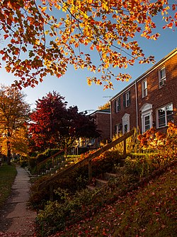
Townhomes on a residential street in the Ridgeleigh area of Parkville, Maryland
Baltimore County Maryland Incorporated and Unincorporated areas Parkville Highlighted.svg
Location of Parkville, Maryland
Coordinates: 39°22′59″N76°33′0″W / 39.38306°N 76.55000°W / 39.38306; -76.55000
CountryFlag of the United States.svg United States
State Flag of Maryland.svg  Maryland
County Flag of Baltimore County, Maryland.svg Baltimore
Area
[1]
  Total4.29 sq mi (11.10 km2)
  Land4.29 sq mi (11.10 km2)
  Water0.00 sq mi (0.00 km2)
Elevation
331 ft (101 m)
Population
 (2020)
  Total31,812
  Density7,424.04/sq mi (2,866.58/km2)
Time zone UTC−5 (Eastern (EST))
  Summer (DST) UTC−4 (EDT)
ZIP code
21234
Area code 410
FIPS code 24-60275
GNIS feature ID0590976

Parkville is an unincorporated community and census-designated place in Baltimore County, Maryland, United States. As of the 2010 census, the population was 30,734. [2]

Contents

Geography

According to the United States Census Bureau, the CDP has a total area of 4.2 square miles (11 km2), all land. The northern border of the CDP is Interstate 695 (the Baltimore Beltway) from Loch Raven Boulevard to Putty Hill Avenue. The eastern border is roughly where Putty Hill Avenue becomes Rossville Boulevard, the southern border is the Baltimore City/Baltimore County line from near Glen Road to Loch Raven Boulevard, and the western boundary is Loch Raven Boulevard from the city line to I-695. [3]

Demographics

Historical population
CensusPop.Note
1960 27,236
1970 33,58923.3%
1980 35,1594.7%
1990 31,617−10.1%
2000 31,118−1.6%
2010 30,734−1.2%
2020 31,8123.5%
U.S. Decennial Census [4] [5]

At the 2000 census there were 31,118 people, 13,044 households, and 8,243 families living in the CDP. The population density was 7,352.1 inhabitants per square mile (2,838.7/km2). There were 13,550 housing units at an average density of 3,201.4 per square mile (1,236.1/km2). The racial makeup of the CDP was 73.64% White, 22.48% African American, 0.16% Native American, 1.88% Asian, 0.02% Pacific Islander, 0.42% from other races, and 1.39% from two or more races. Hispanic or Latino of any race were 1.65%. [6]

Of the 13,044 households 28.3% had children under the age of 18 living with them, 42.8% were married couples living together, 16.2% had a female householder with no husband present, and 36.8% were non-families. 29.8% of households were one person and 11.1% were one person aged 65 or older. The average household size was 2.36 and the average family size was 2.93.

The age distribution was 22.8% under the age of 18, 8.9% from 18 to 24, 30.4% from 25 to 44, 20.8% from 45 to 64, and 17.1% 65 or older. The median age was 38 years. For every 100 females, there were 86.1 males. For every 100 females age 18 and over, there were 81.5 males.

The median income for a household in the CDP was $41,410, and the median family income was $50,421. Males had a median income of $36,728 versus $27,579 for females. The per capita income for the CDP was $20,633. About 6.4% of families and 7.4% of the population were below the poverty line, including 8.9% of those under age 18 and 5.7% of those age 65 or over.

Education

People in Parkville are zoned for the following schools:

Elementary schools

Middle schools

Elementary/middle schools

High schools

Transportation

Roads

Some of the major roads in the Parkville area are:

Public transportation

The Maryland Transit Administration's Bus Route 54 operates along Harford Road between the Carney Park-and-Ride and Downtown Baltimore.

Local culture

An annual Czech and Slovak Heritage Festival is held in Parkville to celebrate the Czech and Slovak heritage of Baltimore. [7] [8]

For several years, Parkville was the primary location for the music festival Stanstock, a nonprofit charity that primarily benefits two local charities, the Nicole Van Horn Foundation and the Catch a Lift Fund. [9] [10] [11]

Related Research Articles

<span class="mw-page-title-main">Ferndale, Maryland</span> Census-designated place in Maryland, United States

Ferndale is a census-designated place (CDP) in Anne Arundel County, Maryland, United States. At the 2010 census, the population was 16,746.

<span class="mw-page-title-main">Severna Park, Maryland</span> Census-designated place in Maryland, United States

Severna Park is a census-designated place (CDP) in Anne Arundel County, Maryland, United States. Severna Park is part of the Baltimore-Washington Metropolitan Area, and is located approximately 8 miles (13 km) north of Annapolis, 17 miles (27 km) south of Baltimore and 39 miles (63 km) east of Washington, D.C. Severna Park's population was 39,933 at the 2020 census.

<span class="mw-page-title-main">Carney, Maryland</span> Census-designated place in Maryland, United States

Carney is an unincorporated community and census-designated place in Baltimore County, Maryland, United States. The population was 29,941 at the 2010 census.

<span class="mw-page-title-main">Hampton, Maryland</span> Census-designated place in Maryland, United States

Hampton is an unincorporated community and census-designated place (CDP) in Baltimore County, Maryland, United States. The population was 5,052 at the 2010 census. Hampton is often considered a subdivision of the nearby community of Towson and is located just north of Baltimore, about twenty minutes from downtown. Hampton contains residences situated on lots up to several acres in a park-like setting. The community is anchored by its principal landmark, the Hampton National Historic Site. The Towson United Methodist Church is located in Hampton, flanked on the south by I-695 and Goucher College.

<span class="mw-page-title-main">Lochearn, Maryland</span> Census-designated place in Maryland, United States

Lochearn is an unincorporated community and census-designated place in Baltimore County, Maryland, United States, located immediately to the west of the City of Baltimore. Per the 2020 census, the population was 25,511.

<span class="mw-page-title-main">Owings Mills, Maryland</span> Census-designated place in Maryland, US

Owings Mills is an unincorporated community and census-designated place in Baltimore County, Maryland, United States. It is a suburb of Baltimore. Per the 2020 census, the population was 35,674. Owings Mills is home to the northern terminus of the Baltimore Metro Subway, and housed the Owings Mills Mall until its closure in 2015. It is also home to the Baltimore Ravens' headquarters facility, and the studios for Maryland Public Television. In 2008, CNNMoney.com named Owings Mills number 49 of the "100 Best Places to Live and Launch".

<span class="mw-page-title-main">Pikesville, Maryland</span> Census-designated place in Maryland, United States

Pikesville is a census-designated place (CDP) in Baltimore County, Maryland, United States. Pikesville is just northwest of the Baltimore city limits. It is the northwestern suburb closest to Baltimore.

<span class="mw-page-title-main">Rosedale, Maryland</span> Census-designated place in Maryland, United States

Rosedale is an unincorporated community and census-designated place in Baltimore County, Maryland, United States. The population was 19,257 at the 2010 United States Census.

<span class="mw-page-title-main">Towson, Maryland</span> Census-designated place in Maryland, United States

Towson is an unincorporated community and a census-designated place in Baltimore County, Maryland, United States. The population was 55,197 as of the 2010 census. It is the county seat of Baltimore County and the second-most populous unincorporated county seat in the United States.

<span class="mw-page-title-main">White Marsh, Maryland</span> Census-designated place in Maryland, United States

White Marsh is an unincorporated community and census-designated place in Baltimore County, Maryland, United States. The population was 9,513 at the 2010 census. White Marsh is a northeast suburb of Baltimore.

<span class="mw-page-title-main">Woodlawn, Baltimore County, Maryland</span> Place in Maryland, United States

Woodlawn is an unincorporated community and census-designated place in Baltimore County, Maryland. Per the 2020 census, the population was 39,986. It is home to the headquarters of the Social Security Administration (SSA) and the Centers for Medicare and Medicaid Services (CMS). It is bordered by Catonsville on the south, by the Patapsco River and Howard County on the west, by Randallstown and Lochearn to the north, and by the City of Baltimore to the east. Parts of Woodlawn are sometimes informally referred to as Security, Maryland, due to the importance of the SSA's headquarters as well as nearby Security Boulevard and Security Square Mall.

<span class="mw-page-title-main">Bel Air South, Maryland</span> Census-designated place in Maryland, United States

Bel Air South is a census-designated place (CDP) in Harford County, Maryland, United States. The population was 47,709 at the 2010 census, up from 39,711 in 2000.

<span class="mw-page-title-main">Fallston, Maryland</span> Census-designated place in Maryland, United States

Fallston is a census-designated place (CDP) in Harford County, Maryland, United States. The population was 8,958 at the 2010 census, up from 8,427 in 2000. Fallston is a semi-rural community consisting mostly of farms and suburban-like developments.

<span class="mw-page-title-main">Pleasant Hills, Maryland</span> Census-designated place in Maryland, United States

Pleasant Hills is a census-designated place (CDP) in Harford County, Maryland, United States. The population was 3,379 at the 2010 census, up from 2,851 in 2000. There is no post office with the designation "Pleasant Hills"; most of the residents have either Fallston or Kingsville addresses and consider themselves as belonging to those communities.

<span class="mw-page-title-main">Maryland Route 41</span> State highway in Maryland, US

Maryland Route 41 is a state highway in the U.S. state of Maryland. Known for most of its length as Perring Parkway, the state highway runs 6.75 miles (10.86 km) from MD 147 in Baltimore north to Waltham Woods Road in Carney. MD 41 is a four- to six-lane divided highway that connects portions of Northeast Baltimore, including Morgan State University, with Parkville and Interstate 695 (I-695). The state highway is maintained by the Maryland State Highway Administration in Baltimore County and the Baltimore City Department of Transportation in the city, where it is unsigned. MD 41 was built in the early to mid-1960s, largely to relieve congestion on portions of neighboring Old Harford and Harford Roads during the period of rapid post-World War II growth in the area.

<span class="mw-page-title-main">Hamilton Hills, Baltimore</span> Neighborhood in Baltimore, Maryland, United States

Hamilton Hills is a mixed-use suburban neighborhood located in the northeastern corner of Baltimore City, Maryland. Hamilton Hills represents a section of Hamilton, a larger historic area that includes other neighborhoods in Northeast Baltimore. The neighborhood's borders are Old Harford Road and Harford Road to the east, Echodale Avenue to the south, Perring Parkway to the west and the Baltimore County line to the north. The main thoroughfare in Hamilton Hills is Harford Road, which has been an integral part of the area's history.

<span class="mw-page-title-main">LocalLink 54 (BaltimoreLink)</span> Bus route operated by the Maryland Transit Administration

Route 54 is a bus route operated by the Maryland Transit Administration in Baltimore and its suburbs. The route was formerly known as Route 19 prior to 2017. The line currently runs from the State Center Metro Subway Station to the intersection of Harford Road and Northern Parkway. From there it splits into two branches. About one half of buses continue operating along Harford Road to the Carney Park-and-Ride just north of the I-695 interchange, and the other half to the intersection of Goucher Boulevard and Taylor Avenue in Towson via Northern, McLean Boulevard, Hillsway, and Taylor. The line serves the communities of Montebello, Hamilton, and Parkville.

<span class="mw-page-title-main">Parkville High School</span> Public school in Parkville, Maryland, United States

Parkville High School (PHS) is a four-year public high school in Baltimore County, Maryland, United States. The school was originally established in 1953 on what is now the location of Parkville Middle School. The current high school building opened in 1961. Area middle schools include Parkville Middle, Loch Raven Academy, and Pine Grove Middle.

<span class="mw-page-title-main">Maryland Route 542</span>

Maryland Route 542 is a state highway in the U.S. state of Maryland. Known for most of its length as Loch Raven Boulevard, the state highway runs 6.33 miles (10.19 km) from MD 147 in Baltimore north to Interstate 695 (I-695) and Cromwell Bridge Road near Towson. MD 542 is a four-lane divided highway that connects portions of Northeast Baltimore with Towson and I-695. The state highway is maintained by the Maryland State Highway Administration in Baltimore County and the Baltimore City Department of Transportation in the city. MD 542 was constructed in the early to mid-1930s. The highway was expanded to a divided highway in Baltimore by 1950 and in Baltimore County in the mid- to late 1950s.

Old Harford Road, one of the oldest continuously used rights-of-way in central Maryland, United States, is a southwest–northeast thoroughfare in northeast Baltimore City and eastern Baltimore County.

References

  1. "2020 U.S. Gazetteer Files". United States Census Bureau. Retrieved April 26, 2022.
  2. "Profile of General Population and Housing Characteristics: 2010 Demographic Profile Data (DP-1): Parkville CDP, Maryland". United States Census Bureau . Retrieved February 29, 2012.
  3. "P.L. 94-171 County Block Map (2010 Census): Baltimore County, MD; Map sheets 65 and 66" (PDF). U.S. Census Bureau. Retrieved February 29, 2012.
  4. "Census of Population and Housing". Census.gov. Retrieved June 4, 2016.
  5. Community not separately delineated in 1960, which the community combined with Carney to form Parkville-Carney, which had a total population of 27,236.
  6. "U.S. Census website". United States Census Bureau . Retrieved January 31, 2008.
  7. "Czech-Slovak festival is Sunday in Parkville". The Baltimore Sun . Retrieved August 10, 2014.
  8. "Czech and Slovak Festival is Sunday". The Baltimore Sun . Retrieved August 10, 2014.
  9. "Pines Resident Recognized for Charitable Efforts" (PDF). The Courier (Delmarva) . Retrieved April 28, 2017.
  10. "A Humanitarian With A Message Of Hope" (PDF). The Courier (Delmarva) . Retrieved April 28, 2017.
  11. "People Are Talking". WJZ-TV . Retrieved May 1, 2017.