Halethorpe, Maryland

Last updated

Halethorpe, Maryland
Motto: 
"Life is heaven in 21227" [1]
Baltimore osm-mapnik location map.png
Red pog.svg
Halethorpe, Maryland
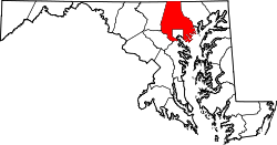
Location within the State of Maryland
Coordinates: 39°14′23″N76°40′49″W / 39.23972°N 76.68028°W / 39.23972; -76.68028
CountryFlag of the United States.svg United States
State Flag of Maryland.svg  Maryland
County Flag of Baltimore County, Maryland.svg Baltimore
EstablishedJune 12, 1893 [2]
Time zone UTC−5 (Eastern (EST))
  Summer (DST) UTC−4 (EDT)
ZIP codes
21227

Halethorpe is an unincorporated community in Baltimore County, Maryland, United States. The community is considered to be a sub-section of Arbutus by the United States Census Bureau. It is bordered by the main portion of Arbutus to the north, Baltimore to the North East, Elkridge to the South West, and Linthicum to the East. It is southeast of the University of Maryland, Baltimore County.

Contents

Fire protection

Halethorpe is home to the Baltimore County Fire Department's Station 5, located on the corner of Washington Boulevard and Halethorpe Farms Road.

Economy

There is a large Alcoa aluminum extrusion plant in Halethorpe that used to be part of Kaiser Aluminum.

The Clipper City Brewing Company, the brewer of Heavy Seas Beer, is located on Hollins Ferry Road in Halethorpe.

Education

Halethorpe has one public school, Halethorpe Elementary. Halethorpe has one non-denominational school, Lamb of God School.

Public transportation

Looking north at a train departing from Halethorpe Station Halethorpe Station Bridge Overlook.jpg
Looking north at a train departing from Halethorpe Station

The Halethorpe community is served by the no. 77 bus line operated by the Maryland Transit Administration.

A stop on the MARC Penn Line on Southwestern Boulevard serves the Halethorpe-Arbutus community. The Maryland Transit Administration and the University of Maryland, Baltimore County provide bus service to the station.

Fair of the Iron Horse (1927)

Halethorpe was the site of the Baltimore and Ohio Railroad's 1927 centenary celebration, the Fair of the Iron Horse. [3] [4] [5]

Related Research Articles

<span class="mw-page-title-main">Arbutus, Maryland</span> Census-designated place in Maryland, United States

Arbutus is an unincorporated community and a census-designated place in Baltimore County, Maryland, United States. The population was 20,483 at the 2010 census. The census area also contains the communities of Halethorpe and Relay, in which all three names were used during the 1960 census when the area had a population of 22,402.

<span class="mw-page-title-main">Catonsville, Maryland</span> Census-designated place in Maryland, United States

Catonsville is a census-designated place (CDP) in Baltimore County, Maryland. The population was 44,701 at the 2020 US Census. The community is a streetcar suburb of Baltimore along the city's western border. The town is known for its proximity to the Patapsco River and Patapsco Valley State Park, making it a regional mountain biking hub. The town is also notable as a local hotbed of music, earning it the official nickname of "Music City, Maryland." Catonsville contains the majority of the University of Maryland, Baltimore County (UMBC), a major public research university with close to 14,000 students.

<span class="mw-page-title-main">Dundalk, Maryland</span> Unincorporated community in Maryland, United States

Dundalk is an unincorporated community and census-designated place in Baltimore County, Maryland, United States. The population was 67,796 at the 2020 census. In 1960 and 1970, Dundalk was the largest unincorporated community in Maryland. It was named after the town of Dundalk in County Louth, Ireland. Dundalk is considered one of the first inner-ring suburbs of Baltimore.

<span class="mw-page-title-main">Elkridge, Maryland</span> Census-designated place in Maryland, United States of America

Elkridge is an unincorporated community and census-designated place (CDP) in Howard County, Maryland, United States. The population was 15,593 at the 2010 census. Founded early in the 18th century, Elkridge is adjacent to two other counties, Anne Arundel and Baltimore.

<span class="mw-page-title-main">Maryland Transit Administration</span> Public transit authority of the state of Maryland

The Maryland Transit Administration (MTA) is a state-operated mass transit administration in Maryland, and is part of the Maryland Department of Transportation. The MTA operates a comprehensive transit system throughout the Washington-Baltimore metropolitan area. There are 80 bus lines serving the Baltimore Metropolitan Area, along with rail services that include the Light Rail, Metro Subway, and MARC Train. In 2023, the system had a ridership of 52,922,000, or about 186,900 per weekday as of the first quarter of 2024.

<span class="mw-page-title-main">Timonium, Maryland</span> Census-designated place in Maryland, United States

Timonium is a census-designated place (CDP) in Baltimore County, Maryland, United States. As of the 2010 census it had a population of 9,926. Prior to 2010 the area was part of the Lutherville-Timonium CDP.

<span class="mw-page-title-main">Lansdowne, Maryland</span> Census-designated place in Maryland, United States

Lansdowne is a census-designated place in southern Baltimore County, Maryland, United States, located just south of Baltimore. As of the 2010 census, it had a population of 8,409. At the 2000 census and earlier, the area was delineated as part of the Lansdowne-Baltimore Highlands CDP.

<span class="mw-page-title-main">Mount Washington, Baltimore</span> United States historic place

Mount Washington is an area of northwest Baltimore, Maryland. It is a designated city historic district and divided into two sections: South Road/Sulgrave to the southeast and Dixon's Hill to the north. The Mount Washington Historic District was listed on the National Register of Historic Places in 1990 with a boundary increase in 2001, with five contributing buildings and four contributing structures.

<span class="mw-page-title-main">St. Denis, Maryland</span> Unincorporated community in Maryland, United States

St. Denis is an unincorporated community in Baltimore County in Central Maryland, United States, located in Arbutus, south of Baltimore.

<span class="mw-page-title-main">U.S. Route 1 in Maryland</span> Section of U.S. Route in Maryland, United States

U.S. Route 1 (US 1) is the easternmost and longest of the major north–south routes of the older 1920s era United States Numbered Highway System, running from Key West, Florida, to Fort Kent, Maine. In the U.S. state of Maryland, it runs 81 miles (130 km) from the Washington, D.C. line to the Pennsylvania state line near the town of Rising Sun.

<span class="mw-page-title-main">CityLink Green (BaltimoreLink)</span> Bus route operated by the Maryland Transit Administration

CityLink Green is a bus route operated by the Maryland Transit Administration in Baltimore and its suburbs. The line currently runs from the Inner Harbor with most trips operating to Cromwell Bridge Road Park and Ride in Baynesville along the corridors of Loch Raven Boulevard and St. Paul Street, with selected trips to Sheppard Pratt Hospital in Towson, mostly via Joppa Road, and some trips making short turns at Loch Raven and Taylor. It is the successor to the 17 St. Paul Street streetcar line that ran from 1893 to 1938 and the Route T bus that ran from 1939 to 1947 and the Route 3 bus which ran until 2017.

<span class="mw-page-title-main">LocalLink 54 (BaltimoreLink)</span> Bus route operated by the Maryland Transit Administration

Route 54 is a bus route operated by the Maryland Transit Administration in Baltimore and its suburbs. The route was formerly known as Route 19 prior to 2017. The line currently runs from the State Center Metro Subway Station to the intersection of Harford Road and Northern Parkway. From there it splits into two branches. About one half of buses continue operating along Harford Road to the Carney Park-and-Ride just north of the I-695 interchange, and the other half to the intersection of Goucher Boulevard and Taylor Avenue in Towson via Northern, McLean Boulevard, Hillsway, and Taylor. The line serves the communities of Montebello, Hamilton, and Parkville.

<span class="mw-page-title-main">LocalLink 56 (BaltimoreLink)</span> Bus route in Baltimore, Maryland and its suburbs

LocalLink Route 56 is a bus route operated by the Maryland Transit Administration in Baltimore and its suburbs. The line runs between the Park and Ride station in White Marsh and Charles Center in Downtown Baltimore. In June 2017, LocalLink 56 replaced the former local bus Route 35, which connected the city's downtown area with White Marsh, to the east of the city, and UMBC to the west. Route 35 was the successor to the No. 3 Wilkens Avenue and No, 6 Monument Street streetcar lines.

<span class="mw-page-title-main">Halethorpe station</span> Railway station in Halethorpe, Maryland

Halethorpe station is a passenger rail station located in the unincorporated community of Halethorpe, Maryland, on the Northeast Corridor. MARC Penn Line trains serve the station; Amtrak trains pass through but do not stop.

<span class="mw-page-title-main">LocalLink 37 (BaltimoreLink)</span> Bus route operated by the Maryland Transit Administration

Route 77 is a bus route operated by the Maryland Transit Administration in the suburbs of Baltimore. The line currently runs from the Old Court Metro Subway Station in Pikesville, Maryland, to the Patapsco Light Rail Stop and serves Randallstown, Windsor Mill, Woodlawn, Catonsville, Arbutus, Halethorpe, and Lansdowne as well as the campuses of UMBC and CCBC Catonsville.

<span class="mw-page-title-main">LocalLink 62 (BaltimoreLink)</span> Bus route operated by the Maryland Transit Administration

LocalLink 62 is a bus route in the suburbs of Baltimore, United States. The line currently runs from the Essex campus of the Community College of Baltimore County to Turner's Station in Dundalk. The current route serves the Rosedale, Middle River, and Essex areas and the CCBC Essex and Dundalk campuses. The line was previously known as Route 4 prior to the launch of BalitmoreLink. LocalLink Route 62 replaced the entirety of Route 4 on June 18, 2017.

<span class="mw-page-title-main">U.S. Route 1 Alternate (Baltimore, Maryland)</span> Highway in Maryland

U.S. Route 1 Alternate is an alternate route of US 1 in the U.S. state of Maryland. The highway runs 3.92 miles (6.31 km) between intersections with US 1 in Arbutus and in Baltimore. US 1 Alt. serves the southwestern Baltimore County community of Halethorpe and connects US 1 with full-access interchanges with Interstate 95 (I-95) and I-695. The Washington Boulevard portion of the alternate route was the original road southwest from Baltimore in the 18th century and was part of the turnpike southwest to Washington, D.C. for much of the 19th century. The highway was paved in the early 1910s, expanded in the late 1910s and late 1920s, and became part of US 1 in 1926. The Caton Avenue portion of the alternate route was improved and expanded in the 1930s to serve as a rerouting of US 1 in southwest Baltimore. US 1 Alt. was created in 1949 when US 1 was moved to its present course through Arbutus and southwest Baltimore. The alternate route's interchanges with I-695 and I-95 were constructed in the late 1950s and mid-1970s, respectively.

<span class="mw-page-title-main">Hawkins Point, Baltimore</span> Neighborhood in Baltimore, Maryland, United States

Hawkins Point is a neighborhood in the South District of Baltimore, located at the southern tip of the city between Curtis Bay (north) and the Anne Arundel County line (south) and Thoms Cove (east). Its land area covers 2.6 square miles (6.7 km2), and it had a population of 24 people according to the 2020 U.S. Census. The neighborhood is predominantly industrial.

<span class="mw-page-title-main">Regional Transportation Agency of Central Maryland</span> American transit organization

Regional Transportation Agency of Central Maryland, locally referred to as the RTA, is a transit organization providing fixed-route and paratransit services across Central Maryland. The RTA is made up of multiple jurisdictions including Anne Arundel County, Howard County, the City of Laurel, Northern Prince George's County, and Baltimore County.

UMBC Transit is the official bus system of the University of Maryland, Baltimore County. Along with the Maryland Transit Administration (MTA), the UMBC community has public transit access to nearby areas such as Catonsville, Arbutus, Maryland, and Baltimore City.
References

  1. https://www.heavenin21227.com/product-category/product-themes/life-is-heaven-category/%5B%5D
  2. "Archived copy" (PDF). www.postalmuseum.si.edu. Archived from the original (PDF) on May 18, 2014. Retrieved January 12, 2022.{{cite web}}: CS1 maint: archived copy as title (link)
  3. Tcakick, Christina (June 6, 2017). "The 1927 "Fair of the Iron Horse"". The Darkroom: Exploring Visual Journalism from the Baltimore Sun. The Baltimore Sun.
  4. "The 'Fair of the Iron Horse'". The Railway and Locomotive Historical Society Bulletin (15): 5–10. 1927. JSTOR   43516849.
  5. Cowan, Katherine. "Fair of the Iron Horse". Prints and photographs collection. Maryland Historical Society. Archived from the original on August 13, 2011. Retrieved December 13, 2011.