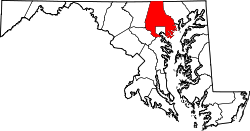
Hunt Valley, Maryland

Last updated

Hunt Valley, Maryland
Baltimore Light Rail train entering Gilroy Road station, March 2000.jpg
Hunt Valley, Maryland, as seen from Gilroy Road
USA Maryland location map.svg
Red pog.svg
Hunt Valley
Location in Maryland
Usa edcp location map.svg
Red pog.svg
Hunt Valley
Hunt Valley (the United States)
Coordinates: 39°30′12″N76°42′10″W / 39.50333°N 76.70278°W / 39.50333; -76.70278
Country Flag of the United States.svg United States
State Flag of Maryland.svg  Maryland
County Flag of Baltimore County, Maryland.svg Baltimore
ZIP codes
21031, 21030
Area code(s) 410, 443
Hunt Valley Towne Centre in Hunt Valley, Maryland HuntValleyTowneCenter.jpg
Hunt Valley Towne Centre in Hunt Valley, Maryland
Hunt Valley Business Park in Hunt Valley, Maryland Hunt Valley Business Community sign.jpg
Hunt Valley Business Park in Hunt Valley, Maryland
Horse Racing right outside Hunt Valley, Maryland Genesee Valley Hunt Races.jpg
Horse Racing right outside Hunt Valley, Maryland

Hunt Valley is an unincorporated community in Baltimore County, Maryland, United States, [1] near the site of the Maryland Hunt Cup Steeplechase. It lies just north of the city of Baltimore, along York Road (Maryland Route 45), parallel to Interstate 83. The nearby Loch Raven Reservoir is an important landmark and drinking water resource. Its surrounding forested watershed is one of three reservoirs (along with Prettyboy and Liberty Reservoirs) established for the City of Baltimore. [2] Hunt Valley is located at a latitude of 39.5° North and longitude of 76.7° West. [3] It is served by the Cockeysville post office, and is also a neighbor of Timonium. A satellite campus of the Community College of Baltimore County is located in Hunt Valley Town Centre.

Contents

Business and industry

An industrial park, named The Hunt Valley Business Community, [4] was opened in 1962. [5] Hunt Valley is the home of AmTote International, Inc., Systems Alliance, Inc., [6] BreakAway Games, Atradius North America, Sinclair Broadcast Group, McCormick & Company, AAI Corporation, Dunbar Armored, [7] TESSCO Technologies, [8] ZeniMax Online Studios, and DrChrono. The Hunt Valley Inn has been the site of Balticon in the past.

McCormick Hq McCormick Hq.jpg
McCormick Hq

Hunt Valley Towne Centre is the main shopping area. It was built on an estate formerly owned by the Grand Lodge of Ancient Free and Accepted Masons of Maryland. Before that, the land was the Merryman family estate, “Bonnie Blink”. [9] It was originally opened as Hunt Valley Mall in 1981, [10] and redeveloped into the current open air Towne Centre in 2005. [11]

Recreation

In 2000 the Maryland Environmental Trust acquired an area encompassing Western Run shoreline, and wetlands, creating a nature preserve and hiking area. [12]

Torrey C. Brown Rail Trail, also known as the NCR , a popular place to hike.

Oregon Ridge Park and Oregon Ridge Nature Center, also with hiking trails. The Nature Center hosts an annual bird count.

Places to see

The System Source Computer Museum houses computing artifacts dating from ancient China to the present day. [13]

Public transportation

Hunt Valley is the northern terminus of the Light Rail line, [14] and is also served by the Route 93 bus.

Related Research Articles

<span class="mw-page-title-main">Owings Mills, Maryland</span> Census-designated place in Maryland, United States

Owings Mills is an unincorporated community and census-designated place in Baltimore County, Maryland, United States. It is a suburb of Baltimore. Per the 2020 census, the population was 35,674. Owings Mills is home to the northern terminus of the Baltimore Metro Subway, and housed the Owings Mills Mall until its closure in 2015. It is also home to the Baltimore Ravens' headquarters facility, and the studios for Maryland Public Television. In 2008, CNNMoney.com named Owings Mills number 49 of the "100 Best Places to Live and Launch".

<span class="mw-page-title-main">Timonium, Maryland</span> Census-designated place in Maryland, United States

Timonium is a census-designated place (CDP) in Baltimore County, Maryland, United States. As of the 2010 census it had a population of 9,926. Prior to 2010 the area was part of the Lutherville-Timonium CDP.

<span class="mw-page-title-main">Prettyboy Reservoir</span> Reservoir in Baltimore County, Maryland

Prettyboy Reservoir is a 1,500-acre (610 ha) reservoir in northern Baltimore County, Maryland, also known as the Hereford Zone. Even though the reservoir is in the county, the City of Baltimore owns the reservoir and the surrounding land of forested watershed. The reservoir is one of three reservoirs created to supply the Metropolitan Baltimore municipal water system for Baltimore City, Baltimore County and northern Anne Arundel County constructed by the Baltimore City Department of Public Works. Prettyboy Reservoir, along with Loch Raven Reservoir that is downstream of the Gunpowder Falls, provide about 61% of the drinking water for the Baltimore Metropolitan system. For this reason, the Prettyboy is considered a "source water" or drinking water watershed. The reservoir on average contains about 19 billion US gallons (72,000,000 m3) of water.

<span class="mw-page-title-main">Torrey C. Brown Rail Trail</span>

The Torrey C. Brown Rail Trail (TCB), the official name of the Northern Central Railroad (NCR) Trail, is a rail trail that runs along an abandoned railroad corridor where the Northern Central Railway once operated. The trail extends 19.7 miles from Ashland Road in Cockeysville, Maryland to the boundary with Pennsylvania. At the Pennsylvania line, the Torrey C. Brown Trail becomes the York County Heritage Rail Trail and continues to the city of York.

<span class="mw-page-title-main">Baltimore Light RailLink</span> Light rail transit system serving Baltimore

Baltimore Light RailLink is a light rail system serving Baltimore, Maryland, United States, and its northern and southern suburbs. It is operated by the Maryland Transit Administration. In downtown Baltimore, it uses city streets. Outside the central portions of the city, the line is built on private rights-of-way, mostly from the defunct Northern Central Railway, Baltimore and Annapolis Railroad and Washington, Baltimore and Annapolis Electric Railway. The system had a ridership of 3,262,100, or about 14,600 per weekday, as of the third quarter of 2023. On December 7, 2023, MTA Maryland announced the system would shut down after inspections revealed a fire hazard, and provided less than 24 hour notice to riders and did not immediately say when service would resume. Officials said that a free shuttle bus service would replace the service as repairs were made to the 53-car fleet.

<span class="mw-page-title-main">East Towne Mall</span> Shopping mall in Wisconsin, United States

East Towne Mall is a shopping mall located on the northeast side of Madison, Wisconsin. The anchor stores are JCPenney, Shoe Carnival, Barnes & Noble, Planet Fitness, Flix Brewhouse, and Dick's Sporting Goods. There are 3 vacant anchor stores that were once Gordmans, Sears and Boston Store.

<span class="mw-page-title-main">Maryland Route 146</span> State highway in Maryland, US

Maryland Route 146 is a state highway in the U.S. state of Maryland. The state highway runs 16.81 miles (27.05 km) from MD 45 in Towson north to MD 23 near Jarrettsville. MD 146 connects Towson with Loch Raven Reservoir, an impoundment of Gunpowder Falls. The state highway also serves the northern Baltimore County community of Jacksonville and Jarrettsville in western Harford County. MD 146 was constructed as two different state highways on either side of Loch Raven Reservoir. The section of the state highway in Towson was built in the 1910s and the portion through Jacksonville to Jarrettsville was constructed in the late 1920s and early 1930s. The gap in MD 146 through Loch Raven Reservoir was filled in two steps of maintenance swaps in the early 1960s and late 1970s.

<span class="mw-page-title-main">Maryland Route 145</span> State highway in Maryland, US

Maryland Route 145 is a state highway in the U.S. state of Maryland. The state highway runs 10.34 miles (16.64 km) from MD 45 in Cockeysville east to MD 165 near Baldwin. MD 145 connects the north-central and eastern portions of Baltimore County via Jacksonville. The first section of the highway was built from Loch Raven Reservoir to Jacksonville in the early 1910s. The remainder of MD 145 east to Baldwin was completed in the mid-1920s. The state highway was extended west to Cockeysville in the early 1980s in a maintenance swap. When MD 145's bridge over Loch Raven Reservoir was replaced in 2000, the old bridge from 1922 was preserved.

<span class="mw-page-title-main">Liberty Reservoir</span> Reservoir in near Eldersburg, Maryland

Liberty Reservoir is a reservoir west of Baltimore, Maryland; about a mile north of Patapsco Valley State Park's McKeldin area. It is owned by the City of Baltimore Department of Public Works, but is located outside the city, and it divides Baltimore and Carroll Counties.

<span class="mw-page-title-main">Hunt Valley Towne Centre</span> Outdoor shopping mall in Hunt Valley, Maryland

Hunt Valley Towne Centre, formerly Hunt Valley Mall, is an outdoor shopping mall in northern Baltimore County, Maryland, with 58 stores. The development was constructed following the closure of Hunt Valley Mall in 2000. The new centre started operating in 2003. The anchor stores in existence today include Dick's Sporting Goods, Burlington Coat Factory and Wegmans. Wal-Mart was located at Hunt Valley mall until late October 2007, when it moved two miles south to Cockeysville, Maryland. It was replaced by Best Buy, which closed in May 2012 as part of a nationwide downsizing. Near a gazebo located in the main street area of the center, there is a memorial to Chuck Thompson. Hunt Valley's official mascot was Hunter the Valley Bear prior to redevelopment.

<span class="mw-page-title-main">Patapsco Valley State Park</span> State park in Maryland, United States

Patapsco Valley State Park is a Maryland state park extending along 32 miles (51 km) of the Patapsco River south and west of the city of Baltimore, Maryland. The park encompasses multiple developed areas on over 14,000 acres (5,700 ha) acres of land, making it Maryland's largest state park. In 2006, it was officially celebrated as Maryland's first state park, its first formation being in 1906. Patapsco Valley State Park is managed by the Maryland Department of Natural Resources.

<span class="mw-page-title-main">Loch Raven Reservoir</span> Reservoir in Baltimore County, Maryland

The Loch Raven Reservoir is a reservoir that provides drinking water for the City of Baltimore and most of Baltimore County, Maryland. It is fed by the Big Gunpowder Falls river, and has a capacity of 23 billion US gallons (87,000,000 m3) of water.

<span class="mw-page-title-main">Lake Roland (Maryland)</span> Reservoir in Baltimore County, Maryland

Lake Roland is a 100-acre (0.40 km2) defunct reservoir in Baltimore County, Maryland. It was named for Roland Run, a nearby stream that feeds the lake and eventually flows into Jones Falls. It runs southeast through the city center to the Northwest Branch of the Patapsco River and the Baltimore Harbor. It is located just north of the Baltimore city limits.

<span class="mw-page-title-main">Hunt Valley station</span> Light rail station in Hunt Valley, Maryland, US

Hunt Valley station is a Baltimore Light Rail station located at the Hunt Valley Towne Centre shopping complex in Hunt Valley, Maryland. The station opened in 1997 as the terminus of a northern extension of the Light Rail system. It has a single island platform serving two tracks, which continue east of the platform as tail tracks.

Greetings & Readings of Hunt Valley was the largest independent bookstore in Baltimore and was a member of the American Booksellers Association. The store occupied 30,000 square feet (2,800 m2) of retail and warehouse space on the second floor of the main Hunt Valley Towne Centre plaza, the final northbound destination of the Baltimore Light Rail, before closing in January 2019.

<span class="mw-page-title-main">Lake Roland (park)</span> United States historic place

Lake Roland is a city/county park encompassing over 500 acres of woodland, wetlands, serpentine barrens, rare plants and rocky plateaus surrounding Lake Roland in Baltimore County, Maryland. The park is located near the intersection of Falls Road and Lake Avenue, adjacent to the Falls Road Light Rail Stop of the Baltimore Light Rail, which runs from Cromwell Station near Glen Burnie in Anne Arundel County in the south to Hunt Valley of Baltimore County. The line runs along a railroad embankment and trestle over the lake above the dam, cutting the park into a two-thirds wooded northern part and the one-third southern portion around the dam, picnic groves, pavilion and pumping station.

<span class="mw-page-title-main">Eastern High School (Maryland)</span> United States historic place

Eastern High School, established in 1844 along with its sister school Western High School, was a historic all-female, public high school located in Baltimore City, Maryland, 21218, U.S.A. Its final building, at 1101 East 33rd Street, is to the west of The Baltimore City College, also at 33rd Street, and across the street from the former site of Memorial Stadium. E.H.S. was operated by the Baltimore City Public Schools system at successive locations until it was closed in 1986. The final building was renovated in the 1990s and is currently owned and used for offices by the Johns Hopkins Medical Institutions. It was listed on the National Register of Historic Places in 2000.

<span class="mw-page-title-main">Historical Society of Baltimore County</span> Organization

The Historical Society of Baltimore County (HSBC) was founded in 1959 with the goal of preserving, interpreting, and illustrating the history of Baltimore County for the benefit of present and future generations of Marylanders, and is a resource for those interested in researching both local and family history. As the HSBC describes it, they "continually accomplish" their mission "through the production of presentations, lectures, workshops, entertaining educational publications, historical tours, and exhibits." Centrally located in Cockeysville, Maryland, the Society operates out of the Agriculture Building, the former Baltimore County Almshouse, which was built in 1872 and used to house the poor and mentally ill of Baltimore County until 1958.

<span class="mw-page-title-main">Union Mills Reservoir</span> Proposed, unfunded, unbuilt reservoir near Union Mills, Carroll County, Maryland, USA

A proposed Union Mills Reservoir represents a half century of efforts by the Commissioners of the Carroll County, Maryland, to build variations on a "dam" or "reservoir" near Union Mills, Maryland, on the Big Pipe Creek, defeated by a petition led by the Carroll County Taxpayers' Committee in the 1970s. The plan may be alive among some county officials but may also be postponed "indefinitely." Land threatened by the reservoir includes the Whittaker Chambers Farm, also known as the Pipe Creek Farm, a National Historic Landmark as well as protected under the Maryland Agricultural Land Preservation Foundation (MALPF).

References

  1. "Cities and Towns of Baltimore County" . Retrieved February 17, 2020.
  2. "About Loch Raven". Loch Raven Trails. Retrieved February 11, 2020.
  3. "Hunt Valley, Maryland". Lat-Long.com. Retrieved February 10, 2020.
  4. Glasgow, Jesse (February 2, 1972). "The Baltimore Sun". ProQuest   536373285.
  5. "Industrial Park Launched". The Sun (Baltimore). May 27, 1962. ProQuest   542519802.
  6. "Contact Us". Systems Alliance, Inc. Retrieved February 10, 2020.
  7. "Dunbar Armored, Inc". Bloomberg. Retrieved February 10, 2020.
  8. "Tessco Support". Tessco. Retrieved February 12, 2020.
  9. Taylor, Stuart S. (May 4, 1973). "Group plans to develop tract on Shawan Road". The Sun (Baltimore).
  10. Jackson, Jacquelyn (September 16, 1981). "Hunt Valley Mall Opens Tomorrow". The Sun. ProQuest   535888303.
  11. Walker, Andrea K. (January 21, 2005). "1st new stores set to open at Hunt Valley". The Sun (Baltimore). ProQuest   406635926.
  12. Atwood, Liz (January 6, 2000). "Hunt Valley property becomes 500th parcel protected by trust". The Sun (Baltimore).
  13. "System Source Computer Museum". The Computer Museum. Retrieved February 14, 2020.
  14. "Light Rail". Maryland Transit Administration. February 12, 2020. Retrieved February 12, 2020.