Torrey C. Brown Rail Trail

Last updated
Torrey C. Brown Rail Trail
NCR Trailbed.jpg
The trail's crushed limestone surface
Length19.7 mi (31.7 km)
Location Upper Marlboro, Maryland to the Maryland-Pennsylvania border and continuing to York, Pennsylvania via York County Heritage Rail Trail
Established1984
Trailheads Cockeysville
New Freedom
UseHiking, biking, horseback riding, fishing, pet walking
DifficultyEasy, level, ADA accessible
SeasonYear-round
MonthsYear-round
Surface Crushed limestone
Right of way Northern Central Railway
Website https://dnr.maryland.gov/publiclands/Pages/central/tcb.aspx
Trail map

Contents

M.P.
[1]
BSicon fCONTg.svg
becomes York County Heritage Rail Trail
19.7
BSicon fSTR+GRZq.svg
Information icon.svg Mason–Dixon line
18.6
BSicon fHST.svg
Parking icon.svg Toilets unisex.svg Information icon.svg Freeland
BSicon fSTR.svg
BSicon RP2q.svg
MD Route 409.svg MD 409 Freeland Rd
15.5
BSicon fHST.svg
Parking icon.svg Information icon.svg Bentley Springs
BSicon fSKRZ-Bu.svg
I-83.svg I-83
BSicon RP2q.svg
BSicon fTUNNEL2.svg
MD Route 45.svg MD 45 York Rd
12.9
BSicon fHST.svg
Parking icon.svg Information icon.svg Parkton
10.8
BSicon fHST.svg
Parking icon.svg Information icon.svg White Hall
7.2
BSicon fHST.svg
Parking icon.svg Toilets unisex.svg Information icon.svg Monkton
BSicon fSTR.svg
BSicon RP2q.svg
MD Route 138.svg MD 138 Monkton Rd
3.8
BSicon fHST.svg
Parking icon.svg Information icon.svg Sparks
2.0
BSicon fHST.svg
Parking icon.svg Information icon.svg Phoenix
0.5
BSicon fHST.svg
Parking icon.svg Information icon.svg Paper Mill
BSicon fSTR.svg
BSicon RP2q.svg
MD Route 145.svg MD 145 Paper Mill Rd
0.0
BSicon fKBHFe.svg
Parking icon.svg Information icon.svg Ashland Rd

The Torrey C. Brown Rail Trail (TCB), the official name of the Northern Central Railroad (NCR) Trail, is a rail trail that runs along an abandoned railroad corridor where the Northern Central Railway once operated. The trail extends 19.7 miles from Ashland Road in Cockeysville, Maryland to the boundary with Pennsylvania. At the Pennsylvania line, the Torrey C. Brown Trail becomes the York County Heritage Rail Trail (part of BicyclePA Route J) and continues to the city of York. [2]

The trail is 10 feet (3.0 m) wide with a stone dust surface and the majority of the trail runs along the Gunpowder River and Beetree Run. [2] Popular activities on the trail include horseback riding, jogging, walking, hiking, fishing and biking. It is open to the public from sunrise to sunset, seven days a week throughout the year. The trail is also pet-friendly as long as the pet is on a leash.

The TCB makes up a segment of the East Coast Greenway, a 3,000 mile long system of trails connecting Maine to Florida.

Historical development

Zero mile of the trail NCRsign.jpg
Zero mile of the trail
Monkton Station MonktonPlace.jpg
Monkton Station

Historical significance

The Northern Central Railway, built in 1832, ran between Baltimore, Maryland, and Sunbury, Pennsylvania, and was one of the oldest rail lines in the country. The railway serviced the growing Baltimore, York and Harrisburg industries, had 46 stops, 22 of which were in Maryland, and operated for 140 years. It carried passengers, people vacationing at Bentley Springs, and freight between Baltimore and York or Harrisburg, Pennsylvania. During the Civil War, the Pennsylvania Railroad-controlled Northern Central served as a major transportation route for supplies, food, clothing, and material, as well as troops heading to the South from Camp Curtin and other Northern military training stations.

Already in financial trouble, the NCR ceased operations between Cockeysville and York in 1972 after Hurricane Agnes battered its bridges. The old bed, which was converted to a rail-trail in 1984, can still be seen today. Historical markers can be found along the trail such as the Monkton Train Station that underwent renovations and is now serving as a museum, gift shop, and ranger station.

History and evolution

In the early 1980s when it was proposed to place the hike and bike trail in the place of the train tracks, a contentious battle raged between property owners and the state. The owners contended that the property was taken under eminent domain for the purpose of train tracks, and that once the property was no longer to be used for a train the property rights should revert to the previous land owners.

The state prevailed in its fight for the property and the Maryland Department of Natural Resources converted the corridor into a trail which opened to the public in 1984. The trail is used by hundreds of people daily by bicycle, foot and horse. The trail also provides access to the Gunpowder River and Loch Raven watershed for boating and fishing. In honor of Dr. Torrey C. Brown's unconditional support for the trail, it was renamed the Torrey C. Brown Rail Trail, after the third Secretary of the Maryland Department of Natural Resources, in 2007.

Trail development

Design and construction

The majority of the trail’s nearly 20 miles is 10 feet wide with a smooth surface of crushed limestone. The trail is wheel-chair accessible. Mile 0 of the Trail is located just off Maryland Route 145 (Ashland Road), where the road's name changes to Paper Mill Road, in a small subdivision, where there is a small parking lot. A larger parking lot is located less than a mile north of Mile 0 on Paper Mill Road, and additional parking lots exist along the length of the trail. [2] Warning signals, mileage markers, signals, and railroad signs are placed throughout the trail to warn and ensure the safety of trail goers.

Trail amenities

Amenities include drinking fountains, picnic tables, benches, and portable restrooms. Within a mile of the trail, there are hotels and motels and there is easy access to a bike shop that rents and repairs bikes. In addition to the renovations to the Monkton Station, there is also the Sparks Bank Nature Center, in Sparks, Maryland.

Community

Trail supporters

The Torrey C. Brown Trail is managed and maintained by the Maryland Department of Natural Resources, a state government agency. The Maryland Park Service's volunteer program is in charge of recruiting volunteers to invest their time in the many trails throughout the state of Maryland. The trail receives state and federal funding as well as donations.

Special events

There are different events hosted every month put together by the Maryland Department of Natural Resources, as well as from outside institutions. Topics include local archaeological and plant-life investigations, night-time bike-rides, inner tubing, and a marathon.

Related Research Articles

<span class="mw-page-title-main">Cockeysville, Maryland</span> Census-designated place in Maryland, United States

Cockeysville is a census-designated place (CDP) in Baltimore County, Maryland, United States. The population was 20,776 at the 2010 census.

<span class="mw-page-title-main">East Coast Greenway</span> Long-distance hiking trail in the United States

The East Coast Greenway is a 3,000-mile (4,800 km) pedestrian and bicycle route between Maine and Florida along the East Coast of the United States. The nonprofit East Coast Greenway Alliance was created in 1991 with the goal to use the entire route with off-road, shared-use paths; as of 2021, over 1,000 mi (1,600 km) of the route (35%) meets this criteria. In 2020, the Greenway received over 50 million visits.

<span class="mw-page-title-main">Hunt Valley, Maryland</span> Unincorporated community in Maryland, United States

Hunt Valley is an unincorporated community in Baltimore County, Maryland, United States, near the site of the Maryland Hunt Cup Steeplechase. It lies just north of the city of Baltimore, along York Road, parallel to Interstate 83. The nearby Loch Raven Reservoir is an important landmark and drinking water resource. Its surrounding forested watershed is one of three reservoirs established for the City of Baltimore. Hunt Valley is located at a latitude of 39.5° North and longitude of 76.7° West. It is served by the Cockeysville post office, and is also a neighbor of Timonium. A satellite campus of the Community College of Baltimore County is located in Hunt Valley Town Centre.

<span class="mw-page-title-main">U.S. Route 111</span>

U.S. Route 111 (US 111) was a U.S. Highway that extended from Baltimore, Maryland north to the Harrisburg, Pennsylvania area. It replaced part of the Susquehanna Trail, partially signed as Pennsylvania Route 4, and was in turn replaced by Interstate 83 (I-83). Portions of its pre-freeway alignment are now Maryland Route 45 and I-83 Business. Other old sections in Pennsylvania are now unsigned Quadrant Routes or township-maintained roads. US 111 extended north to the Pennsylvania–New York state line where U.S. Route 15 now crosses it between 1928 and 1937.

<span class="mw-page-title-main">Maryland Route 45</span> State highway in Maryland, US

Maryland Route 45 is a state highway in the U.S. state of Maryland. Known for most of its length as York Road, the state highway runs 30.06 miles (48.38 km) from U.S. Route 1 /US 40 Truck in Baltimore north to the Pennsylvania state line in Maryland Line, where the highway continues as State Route 3001. MD 45 is the primary highway between Downtown Baltimore and Towson, the county seat of Baltimore County. North of Interstate 695 (I-695), the state highway parallels I-83 and serves the suburban communities of Lutherville, Timonium, Cockeysville, and Hunt Valley. MD 45 also connects the northern Baltimore County communities of Hereford and Parkton. The state highway is maintained by the Maryland State Highway Administration in Baltimore County and by the Baltimore City Department of Transportation in the city, where the highway also follows Greenmount Avenue.

<span class="mw-page-title-main">Northern Central Railway</span> Railway connecting Baltimore MD and Sunbury PA, US

The Northern Central Railway (NCRY) was a Class I Railroad in the United States connecting Baltimore, Maryland, with Sunbury, Pennsylvania, along the Susquehanna River. Completed in 1858, the line came under the control of the Pennsylvania Railroad (PRR) in 1861, when the PRR acquired a controlling interest in the Northern Central's stock to compete with the rival Baltimore and Ohio Railroad (B&O).

<span class="mw-page-title-main">Sparks, Maryland</span> Unincorporated community in Maryland, United States

Sparks is an unincorporated community that is located in Baltimore County, Maryland, United States. It is situated approximately 20 miles (32 km) north of Baltimore and is considered to be a suburb of the City of Baltimore. The Gunpowder River runs through Sparks.

<span class="mw-page-title-main">Ohiopyle State Park</span>

Ohiopyle State Park is a Pennsylvania state park on 20,500 acres (8,300 ha) in Dunbar, Henry Clay and Stewart Townships, Fayette County, Pennsylvania in the United States. The focal point of the park is the more than 14 miles (23 km) of the Youghiogheny River Gorge that passes through the park. The river provides some of the best whitewater boating in the Eastern United States. Ohiopyle State Park is bisected by Pennsylvania Route 381 south of the Pennsylvania Turnpike. The park opened to the public in 1965 but was not officially dedicated until 1971.

Monkton is an unincorporated community in northern Baltimore County, Maryland, United States. It has a population of approximately 4,856 people. The community is 35 square miles (91 km2) in area, with approximately 138 inhabitants per square mile (53/km2). As an unincorporated area, Monkton has no legally defined boundaries, and its ZIP code (21111) includes a portion of adjacent Harford County.

<span class="mw-page-title-main">Maryland Route 145</span> State highway in Maryland, US

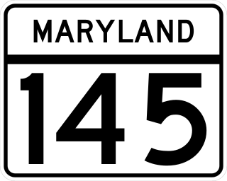
Maryland Route 145 is a state highway in the U.S. state of Maryland. The state highway runs 10.34 miles (16.64 km) from MD 45 in Cockeysville east to MD 165 near Baldwin. MD 145 connects the north-central and eastern portions of Baltimore County via Jacksonville. The first section of the highway was built from Loch Raven Reservoir to Jacksonville in the early 1910s. The remainder of MD 145 east to Baldwin was completed in the mid-1920s. The state highway was extended west to Cockeysville in the early 1980s in a maintenance swap. When MD 145's bridge over Loch Raven Reservoir was replaced in 2000, the old bridge from 1922 was preserved.

<span class="mw-page-title-main">White Clay Creek Preserve</span> State park in Chester County, Pennsylvania

White Clay Creek Preserve is a 3,050-acre (1,230 ha) Pennsylvania state park along the valley of White Clay Creek in London Britain Township in Chester County, Pennsylvania in the United States. The park was donated by the DuPont Company in 1984 for the purpose of "preserving the diverse and unique plant and animal species, and the rich cultural heritage of the area". Dupont also donated an additional 528 acres (214 ha) for the adjoining White Clay Creek State Park to the state of Delaware. White Clay Creek Preserve is 3 miles (4.8 km) north of Newark, Delaware on Pennsylvania Route 896.

<span class="mw-page-title-main">York County Heritage Rail Trail</span> Rail and trail in Pennsylvania

Heritage Rail Trail County Park is a National Recreation Trail rail-with-trail in Pennsylvania built in 1999 by the York County Rail Trail Authority (YCRTA). It connects with the Torrey C. Brown Rail Trail in Maryland. The trail runs along the active Northern Central Railway line and forms the southernmost part of Route J in the BicyclePA route system.

<span class="mw-page-title-main">Pine Creek Rail Trail</span> Rail trail in Pennsylvania, United States

The Pine Creek Rail Trail is the only rail trail in the Appalachian Mountains of north-central Pennsylvania.

<span class="mw-page-title-main">Falls Road station</span> Light Rail station in Towson, Maryland, US

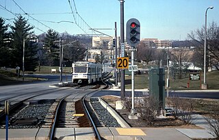
Falls Road station is a Baltimore Light Rail station in the southwest corner of Towson, Maryland, located near the Mount Washington neighborhood of Baltimore and the Bare Hills Historic District in the Jones Falls Valley. It has two side platforms serving two tracks, one in each direction. A 0.3 mile boardwalk provides access from the parking lot to neighboring Lake Roland Park.

<span class="mw-page-title-main">Gunpowder Falls State Park</span> State park in Maryland, United States

Gunpowder Falls State Park is a public recreation area comprising six non-contiguous areas covering 18,000 acres (7,300 ha) in northeastern Baltimore County and western Harford County, Maryland. The state park is primarily made up of the stream valleys of the Big and Little Gunpowder Falls and the Gunpowder River; its natural features range from tidal marshes to rugged interior slopes. The park has over 120 miles of trails for hiking, biking, horseback riding, and cross-country skiing plus facilities for picnicking, tubing, canoeing and kayaking, tide-water fishing and crabbing, fly fishing, and hunting, among other activities. It is managed by the Maryland Department of Natural Resources.

<span class="mw-page-title-main">St. James Church (Monkton, Maryland)</span> Historic church in Maryland, United States

St. James Church is a historic Episcopal church located at Monkton, Baltimore County, Maryland, US.

<span class="mw-page-title-main">Maryland Route 138</span> State highway in Maryland, US

Maryland Route 138 is a state highway in the U.S. state of Maryland. The state highway runs 9.24 miles (14.87 km) from MD 45 in Hereford east to MD 23 near Shawsville. MD 138 connects northern Baltimore County with northwestern Harford County via the community of Monkton on Gunpowder Falls. The first section of the state highway was built east of Monkton in the 1910s. The remainder of MD 138 was built west of Monkton in the mid-1920s and east of Monkton in the early to mid-1930s. The state highway through Monkton was maintained by Baltimore County from the late 1960s to the mid-1990s, during which the highway was relocated at Gunpowder Falls.

The Cumberland County Biker/Hiker Trail is a Pennsylvania rail trail at Pine Grove Furnace State Park and is almost entirely on the "Old Railroad Bed Road" between Fuller Lake and Laurel Lake. The trail is a pleasant 2.2 miles within the Pine Grove Furnace State Park located in the Michaux State Forest. The park is home to many species of wildlife and is a common attraction for locals and tourists alike. Walking, hiking, and biking are the opportunities offered by the trail year round. The biker/hiker trail shares roughly half of its trail with the Appalachian Trail and is a very popular route within the State Park.

<span class="mw-page-title-main">Torrey C. Brown</span> American politician

Torrey C. Brown was an American politician who served in the Maryland House of Delegates and was the Secretary of the Maryland Department of Natural Resources.

References

  1. "NCR Trail Snails" . Retrieved 23 May 2021.
  2. 1 2 3 "Maryland Trails Program: Torrey C. Brown Rail Trail". Maryland Department of Natural Resources. Retrieved February 22, 2020.