Hampton, Maryland

Last updated
Hampton, Maryland
Hampton Natl Historic Site.jpg
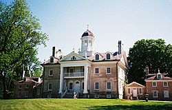
The Hampton National Historic Site in Hampton, Maryland
Baltimore County Maryland Incorporated and Unincorporated areas Hampton Highlighted.svg
Location of Hampton in the State of Maryland
Coordinates: 39°25′22″N76°35′5″W / 39.42278°N 76.58472°W / 39.42278; -76.58472 Coordinates: 39°25′22″N76°35′5″W / 39.42278°N 76.58472°W / 39.42278; -76.58472
Country Flag of the United States.svg United States
State Flag of Maryland.svg  Maryland
County Flag of Baltimore County, Maryland.svg Baltimore
Area
[1]
  Total6.35 sq mi (16.45 km2)
  Land5.95 sq mi (15.41 km2)
  Water0.40 sq mi (1.04 km2)
Elevation
338 ft (103 m)
Population
 (2020)
  Total5,180
  Density870.44/sq mi (336.08/km2)
Time zone UTC-5 (Eastern (EST))
  Summer (DST) UTC-4 (EDT)
ZIP codes
21286
Area code 410 / 443
FIPS code 24-36512
GNIS feature ID0590409

Hampton is an unincorporated community and census-designated place (CDP) in Baltimore County, Maryland, United States. The population was 5,052 at the 2010 census. [2] Hampton is often considered a subdivision of the nearby community of Towson and is located just north of Baltimore, about twenty minutes from downtown. Hampton contains residences situated on lots up to several acres in a park-like setting (current zoning limits density to not more than two residential units per acre). The community is anchored by its principal landmark, the Hampton National Historic Site. The Towson United Methodist Church is located in Hampton, flanked on the south by I-695 and Goucher College.

Contents

History

In ancient times, the land was frequented by Susquehannock Indians, who used what became nearby Joppa Road as a trail. The area now known as Hampton was originally part of a land grant given to a relative of Lord Baltimore in 1695. [3] His heirs sold the land on April 2, 1745, to Col. Charles Ridgely (170272), a tobacco farmer and trader. In the latter half of the 18th century, the Hampton Mansion was built by the Ridgely family, who used the surrounding land for farming, including apple orchards and the breeding of thoroughbred race horses, along with slave quarters.

Succeeding generations of Ridgelys continued to own the land until 1929, when the Hampton Development Company was formed and the land around the Hampton Mansion was subdivided, creating the modern Hampton community. The Hampton Mansion continued to be owned by the Ridgely family until 1948, when the house and the remaining 43 acres (170,000 m2) of the Ridgely estate were designated a National Historic Site and sold to a preservation trust, eventually to be acquired and now operated by the National Park Service. [3]

In 1958, the Towson United Methodist Church completed construction of its large Georgian-style sanctuary with a 235-foot (72 m) spire on 16 acres (65,000 m2) of land in Hampton. [3] In 2008, the church announced plans to sell a 5-acre (20,000 m2) outparcel of undeveloped, wooded property to a developer for construction of a senior housing complex. [4] A zoning change application was submitted to Baltimore County to increase density to 16 residential units per acre. However, the Hampton Improvement Association, representing neighborhood residents, objected, saying they "oppose zoning changes that would allow higher density residential development and require trees to be knocked down". [4] The church subsequently dropped plans for the development, saying it wished to remain a good neighbor. [5] The church now has a walking path in the forested area for meditation, open to the public during daylight hours.

Geography

Hampton is located at 39°25′22″N76°35′5″W / 39.42278°N 76.58472°W / 39.42278; -76.58472 (39.4229, -76.5847). [6]

According to the United States Census Bureau, the CDP has a total area of 5.7 square miles (15 km2), all land.

Climate

The climate in this area is characterized by hot, humid summers and generally mild to cool winters. According to the Köppen Climate Classification system, Hampton has a humid subtropical climate, abbreviated "Cfa" on climate maps. [7]

Demographics

Historical population
CensusPop.Note
1980 5,220
1990 4,926−5.6%
2000 5,0041.6%
2010 5,0521.0%
2020 5,1802.5%
U.S. Decennial Census [8]
Typical residence in Hampton Hampton (MD) typical home.jpg
Typical residence in Hampton

As of the census [9] of 2000, there were 5,004 people, 1,900 households, and 1,578 families residing in the CDP. The population density was 876.2 inhabitants per square mile (338.3/km2). There were 1,935 housing units at an average density of 338.8 per square mile (130.8/km2). The racial makeup of the CDP was 91.41% White, 1.48% African American, 6.00% Asian, 0.02% Pacific Islander, 0.22% from other races, and 0.88% from two or more races. Hispanic or Latino of any race were 1.48% of the population.

There were 1,900 households, out of which 29.1% had children under the age of 18 living with them, 75.3% were married couples living together, 5.7% had a female householder with no husband present, and 16.9% were non-families. 14.3% of all households were made up of individuals, and 8.8% had someone living alone who was 65 years of age or older. The average household size was 2.62 and the average family size was 2.89.

In the CDP, the population was spread out, with 21.9% under the age of 18, 4.1% from 18 to 24, 19.3% from 25 to 44, 30.1% from 45 to 64, and 24.5% who were 65 years of age or older. The median age was 48 years. For every 100 females, there were 94.2 males. For every 100 females age 18 and over, there were 91.5 males.

The median income for a household in the CDP was $95,546, and the median income for a family was $100,240. Males had a median income of $75,518 versus $42,479 for females. The per capita income for the CDP was $43,850. About 0.4% of families and 1.8% of the population were below the poverty line, including 1.3% of those under age 18 and 2.6% of those age 65 or over.

Schools

Hampton is served by these public schools:

Notre Dame Preparatory School, a private, Catholic school for girls, is located in Hampton.

Related Research Articles

<span class="mw-page-title-main">Baltimore County, Maryland</span> County in Maryland, United States

Baltimore County is the third-most populous county in the U.S. state of Maryland and is part of the Baltimore metropolitan area. Baltimore County is part of the Northeast megalopolis, which stretches from Northern Virginia northward to Boston. Baltimore County hosts a diversified economy, with particular emphasis on education, government, and health care. As of the 2020 census, the population was 854,535.

<span class="mw-page-title-main">Gulkana, Alaska</span> CDP in Alaska, United States

Gulkana is a census-designated place (CDP) in Copper River Census Area, Alaska, U.S. At the 2020 census the population was 110, down from 119 in 2010. It also has an airport.

<span class="mw-page-title-main">Orangetree, Florida</span> Census-designated place in Florida

Orangetree is a census-designated place (CDP) in Collier County, Florida, United States. The population was 4,406 at the 2010 census, up from 950 in 2000. It is part of the Naples–Marco Island Metropolitan Statistical Area.

<span class="mw-page-title-main">Crownsville, Maryland</span> Census-designated place in Maryland, United States

Crownsville is a census-designated place (CDP) in Anne Arundel County, Maryland, United States. The population was 1,757 at the 2010 census. It hosts the Anne Arundel County Fair each September, as well as the annual Maryland Renaissance Festival for several summer weekends. A state psychiatric hospital was formerly in Crownsville. The area offers waterfront scenery and easy access to urban metropolitan areas and culture.

<span class="mw-page-title-main">Ferndale, Maryland</span> Census-designated place in Maryland, United States

Ferndale is a census-designated place (CDP) in Anne Arundel County, Maryland, United States. At the 2010 census, the population was 16,746.

<span class="mw-page-title-main">Odenton, Maryland</span> Census-designated place in Maryland, U.S.

Odenton is a census-designated place (CDP) in Anne Arundel County, Maryland, United States, located approximately 10–20 minutes from the state capital, Annapolis. The population was 37,132 at the 2010 census, up from 20,534 at the 2000 census. The town's population growth rate of 80.8% between 2000 and 2010 was the greatest of any town in western Anne Arundel County. Odenton is located west of Annapolis, south of Baltimore, and northeast of Washington.

<span class="mw-page-title-main">Carney, Maryland</span> Census-designated place in Maryland, United States

Carney is an unincorporated community and census-designated place in Baltimore County, Maryland, United States. The population was 29,941 at the 2010 census.

<span class="mw-page-title-main">Lochearn, Maryland</span> Census-designated place in Maryland, United States

Lochearn is an unincorporated community and census-designated place in Baltimore County, Maryland, United States, located immediately to the west of the City of Baltimore. Per the 2020 census, the population was 25,511.

<span class="mw-page-title-main">Milford Mill, Maryland</span> Census-designated place in Maryland, United States

Milford Mill is an unincorporated community and census-designated place in Baltimore County, Maryland, United States. Per the 2020 census, the population was 30,622.

<span class="mw-page-title-main">Overlea, Maryland</span> Census-designated place in Maryland, United States

Overlea is an unincorporated community and census-designated place in Baltimore County, Maryland, United States. The population was 12,275 at the 2010 census. Students attend Overlea High School. Area roads include Belair Road and Kenwood Avenue.

<span class="mw-page-title-main">Parkville, Maryland</span> Census-designated place in Maryland, United States

Parkville is an unincorporated community and census-designated place in Baltimore County, Maryland, United States. As of the 2010 census, the population was 30,734.

<span class="mw-page-title-main">Rosedale, Maryland</span> Census-designated place in Maryland, United States

Rosedale is an unincorporated community and census-designated place in Baltimore County, Maryland, United States. The population was 19,257 at the 2010 United States Census.

<span class="mw-page-title-main">Towson, Maryland</span> Census-designated place in Maryland, United States

Towson is an unincorporated community and a census-designated place in Baltimore County, Maryland, United States. The population was 55,197 as of the 2010 census. It is the county seat of Baltimore County and the second-most populous unincorporated county seat in the United States.

<span class="mw-page-title-main">White Marsh, Maryland</span> Census-designated place in Maryland, United States

White Marsh is an unincorporated community and census-designated place in Baltimore County, Maryland, United States. The population was 9,513 at the 2010 census. White Marsh is a northeast suburb of Baltimore.

<span class="mw-page-title-main">Jarrettsville, Maryland</span> Census-designated place in Maryland, United States

Jarrettsville is an unincorporated community and census-designated place (CDP) in Harford County, Maryland, United States. The population was 2,888 at the 2020 census.

<span class="mw-page-title-main">Perryman, Maryland</span> Census-designated place in Maryland, United States

Perryman is an unincorporated community and census-designated place (CDP) in Harford County, Maryland, United States. The population was 2,342 at the 2010 census.

<span class="mw-page-title-main">Potomac, Maryland</span> Census-designated place in Maryland, United States

Potomac is a census-designated place (CDP) in Montgomery County, Maryland. It is named after the nearby Potomac River. Potomac is the seventh most educated small town in America, based on percentage of residents with postsecondary degrees.

<span class="mw-page-title-main">Cashiers, North Carolina</span> Unincorporated village in Jackson County, North Carolina

Cashiers is a census-designated place (CDP) and unincorporated village located in southern Jackson County, North Carolina, United States. As of the 2020 United States census, the community had a total population of 657, up from 157 at the 2010 census. Cashiers is pronounced KASH-erz locally, and is one of several communities in the area popular with tourists and owners of vacation homes.

<span class="mw-page-title-main">Jessup, Maryland</span> Census-designated place in Maryland

Jessup is an unincorporated community and census-designated place in Howard and Anne Arundel counties, about 15 miles (24 km) southwest of Baltimore, Maryland, United States. Per the 2020 census, the population was 10,535.

<span class="mw-page-title-main">Lutherville, Maryland</span> Census-designated place in Maryland, United States

Lutherville is a census-designated place (CDP) in Baltimore County, Maryland, United States. As of the 2010 census it had a population of 6,504. Prior to 2010 the area was part of the Lutherville-Timonium CDP. Within its borders lies the Lutherville Historic District.

References

  1. "2020 U.S. Gazetteer Files". United States Census Bureau. Retrieved April 26, 2022.
  2. "Profile of General Population and Housing Characteristics: 2010 Demographic Profile Data (DP-1): Hampton CDP, Maryland". United States Census Bureau . Retrieved February 23, 2012.
  3. 1 2 3 Ann Milkovich McKee (2007). Images of America Hampton National Historic Site. Charleston, SC: Arcadia Publishing. ISBN   978-0-7385-4418-2.
  4. 1 2 Laura Barnhardt (February 18, 2008). "Hampton residents fight development". The Baltimore Sun . Retrieved September 23, 2019.
  5. Loni Ingraham (2008-03-12). "Developer drops plan for Hampton Lane". Towson Times.
  6. "Hampton". Geographic Names Information System . United States Geological Survey, United States Department of the Interior . Retrieved 2009-05-03.
  7. Climate Summary for Hampton, Maryland
  8. "Census of Population and Housing". Census.gov. Retrieved June 4, 2016.
  9. "U.S. Census website". United States Census Bureau . Retrieved 2008-01-31.