Baltimore Highlands, Maryland

Last updated

Baltimore Highlands, Maryland
2020-08-06 13 48 05 View north along Maryland State Route 648 (Annapolis Road) from the overpass for Interstate 895 (Baltimore Harbor Tunnel Thruway) in Baltimore Highlands, Baltimore County, Maryland.jpg
View of the Annapolis Road corridor which runs through the Baltimore Highlands area
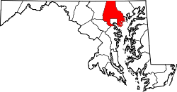
Baltimore County Maryland Incorporated and Unincorporated areas Lansdowne-Baltimore Highlands Highlighted.svg
Location of Baltimore Highlands, Maryland
Coordinates: 39°14′09″N76°38′14″W / 39.23583°N 76.63722°W / 39.23583; -76.63722
CountryFlag of the United States.svg United States
State Flag of Maryland.svg  Maryland
County Flag of Baltimore County, Maryland.svg Baltimore
Area
[1]
  Total1.82 sq mi (4.71 km2)
  Land1.73 sq mi (4.49 km2)
  Water0.08 sq mi (0.22 km2)
Population
 (2020)
  Total7,740
  Density4,463.67/sq mi (1,723.64/km2)
Time zone UTC−5 (Eastern (EST))
  Summer (DST) UTC−4 (EDT)
ZIP code
21227
Area code 410 and 443
FIPS code 24-04050

Baltimore Highlands is a census-designated place (CDP) in Baltimore County, Maryland, United States, directly south of the city of Baltimore. The population was 7,019 at the 2010 census. [2] At the 2000 census and earlier, the area was delineated as part of the Lansdowne-Baltimore Highlands CDP.

Contents

History

In the area known as Baltimore Highlands is a legendary mansion called English Consul. The land and house were owned by William Dawson, the first English Consul to Maryland. One legend claims that Dawson had a brother who was transported from England to America in disgrace. Each year he was to receive a whip lashing as punishment for the crime he had committed. This took place on the English Consul estate. Another legend has it that the mansion was a stop on the Underground Railroad before the Civil War. In 1909 a developer purchased the estate. It was eventually divided into the areas known as Baltimore Highlands, Rosemont, Friendship Gardens and the small section still called English Consul.

In the 1980s Baltimore County Recreation and Parks opened a large parcel of land for public use. Southwest Area Park is located on the Patapsco River just below Baltimore Highlands.

Geography

Baltimore Highlands is located at 39°14′09″N76°38′14″W / 39.23583°N 76.63722°W / 39.23583; -76.63722 (39.2359, 76.6374). [3] It is bounded to the northeast by the border of Baltimore City, to the west by the Baltimore–Washington Parkway, separating the area from Lansdowne, and to the south and southeast by the Patapsco River, which forms the boundary with Anne Arundel County.

According to the United States Census Bureau, the CDP has a total area of 1.8 square miles (4.7 km2), of which 1.7 square miles (4.5 km2) is land and 0.08 square miles (0.2 km2), or 4.80%, is water. [4]

Transit

The community is served by Baltimore Light Rail, which stops at the Baltimore Highlands station.

Baltimore Highlands station Baltimore Highlands station.jpg
Baltimore Highlands station

Roads

Annapolis Road (Maryland Route 648) runs north–south through Baltimore Highlands. To the north it enters Baltimore City, where it crosses West Patapsco Avenue. To the south, it crosses the Patapsco River into the Pumphrey section of Anne Arundel County and an intersection with Maryland Route 170.

Demographics

Historical population
CensusPop.Note
1960 13,134
1970 17,77035.3%
1980 16,759−5.7%
1990 15,509−7.5%
2000 15,7241.4%
2010 7,019−55.4%
2020 7,74010.3%
Separated from Lansdowne-Baltimore Highlands CDP in 2010 Census [5]

2020 census

Baltimore Highlands CDP, Maryland – racial and ethnic composition
Note: the US Census treats Hispanic/Latino as an ethnic category. This table excludes Latinos from the racial categories and assigns them to a separate category. Hispanics/Latinos may be of any race.
Race / Ethnicity (NH = Non-Hispanic)Pop 2010 [6] Pop 2020 [7] % 2010% 2020
White alone (NH)4,0853,40858.20%44.03%
Black or African American alone (NH)1,4861,55021.17%20.03%
Native American or Alaska Native alone (NH)18180.26%0.23%
Asian alone (NH)1993002.84%3.88%
Pacific Islander alone (NH)830.11%0.04%
Some Other Race alone (NH)2590.03%0.76%
Mixed Race/Multi-Racial (NH)2134033.03%5.21%
Hispanic or Latino (any race)1,0081,99914.36%25.83%
Total7,0197,740100.00%100.00%

At the 2010 census there were 7,019 people, 2,525 households, and 1,751 families in the CDP. The population density was 3,870 inhabitants per square mile (1,490/km2). There were 2,708 housing units at an average density of 1,592.9 per square mile (615.0/km2). The racial makeup of the CDP was 63.8% White, 21.7% African American, 0.4% Native American, 2.8% Asian, 0.1% Pacific Islander, 7.3 some other race, and 3.9% from two or more races. Hispanic or Latino of any race were 14.4%. [8]

Of the 2,525 households 32.1% had children under the age of 18 living with them, 39.0% were headed by married couples living together, 22.0% had a female householder with no husband present, and 30.7% were non-families. 22.1% of households were made up of individuals, and 6.3% were one person aged 65 or older. The average household size was 2.78, and the average family size was 3.20.

The age distribution was 25.3% under the age of 18, 12.5% from 18 to 24, 29.5% from 25 to 44, 23.8% from 45 to 64, and 8.7% 65 or older. The median age was 31.7 years. For every 100 females, there were 96.1 males. For every 100 females age 18 and over, there were 94.0 males.

Related Research Articles

<span class="mw-page-title-main">Brooklyn Park, Maryland</span> Census-designated place in Maryland, United States

Brooklyn Park is a census-designated place (CDP) in Anne Arundel County, Maryland, United States. The population was 14,373 at the 2010 census.

<span class="mw-page-title-main">Ferndale, Maryland</span> Census-designated place in Maryland, United States

Ferndale is a census-designated place (CDP) in Anne Arundel County, Maryland, United States. At the 2010 census, the population was 16,746.

<span class="mw-page-title-main">Linthicum, Maryland</span> Census-designated place in Maryland, United States

Linthicum is a census-designated place (CDP) and unincorporated community in Anne Arundel County, Maryland, United States. The population was 10,324 at the 2010 census. It is located directly north of Baltimore–Washington International Thurgood Marshall Airport (BWI).

<span class="mw-page-title-main">Pasadena, Maryland</span> Census-designated place in Maryland, United States

Pasadena is a census-designated place (CDP) in Anne Arundel County, Maryland, United States. The population was 24,287 at the 2010 census.

<span class="mw-page-title-main">Pumphrey, Maryland</span> Unincorporated community in Maryland, United States

Pumphrey is an unincorporated community and former census-designated place (CDP) in Anne Arundel County, Maryland, United States. At the 2000 census, the population was 5,317. It was split between the Linthicum and Brooklyn Park CDPs for the 2010 census.

<span class="mw-page-title-main">Riviera Beach, Maryland</span> Census-designated place in Maryland, United States

Riviera Beach is a census-designated place in Anne Arundel County, Maryland, United States. The population was 12,677 at the 2010 U.S. census.

<span class="mw-page-title-main">Arbutus, Maryland</span> Census-designated place in Maryland, United States

Arbutus is an unincorporated community and a census-designated place in Baltimore County, Maryland, United States. The population was 20,483 at the 2010 census. The census area also contains the communities of Halethorpe and Relay, in which all three names were used during the 1960 census when the area had a population of 22,402.

<span class="mw-page-title-main">Edgemere, Maryland</span> Census-designated place in Maryland, United States

Edgemere is an unincorporated community and census-designated place in Baltimore County, Maryland, United States. The population was 8,669 at the 2010 census. Founded in 1899 as Edgemere being renamed from previous name "Fitzell". Meeting held at the Fitzell Farm which was situated where the old Rheem plant was located.

<span class="mw-page-title-main">Lansdowne-Baltimore Highlands, Maryland</span> Former census-designated place in Maryland, United States

Lansdowne-Baltimore Highlands was a census-designated place (CDP) in Baltimore County, Maryland, United States. The population was 15,724 at the 2000 census. At the 2010 census the area was split into two separate CDPs, the unincorporated communities of Lansdowne and Baltimore Highlands.

<span class="mw-page-title-main">Lochearn, Maryland</span> Census-designated place in Maryland, United States

Lochearn is an unincorporated community and census-designated place in Baltimore County, Maryland, United States, located immediately to the west of the City of Baltimore. Per the 2020 census, the population was 25,511.

<span class="mw-page-title-main">Milford Mill, Maryland</span> Census-designated place in Maryland, United States

Milford Mill is an unincorporated community and census-designated place in Baltimore County, Maryland, United States. Per the 2020 census, the population was 30,622.

<span class="mw-page-title-main">Owings Mills, Maryland</span> Census-designated place in Maryland, United States

Owings Mills is an unincorporated community and census-designated place in Baltimore County, Maryland, United States. It is a suburb of Baltimore. Per the 2020 census, the population was 35,674. Owings Mills is home to the northern terminus of the Baltimore Metro Subway, and housed the Owings Mills Mall until its closure in 2015. It is also home to the Baltimore Ravens' headquarters facility, and the studios for Maryland Public Television. In 2008, CNNMoney.com named Owings Mills number 49 of the "100 Best Places to Live and Launch".

<span class="mw-page-title-main">Randallstown, Maryland</span> Census-designated place in Maryland, United States

Randallstown is an unincorporated community and census-designated place in Baltimore County, Maryland, United States. It is named after Christopher and Thomas Randall, two 18th-century tavern-keepers. At that time, Randallstown was a tollgate crossroads on the Liberty Turnpike, a major east–west thoroughfare. It is a suburb of Baltimore, with a population of 33,655 as of the 2020 census. As of 2020 it was 72 percent African American. In the 1990s, Randallstown transitioned to a majority African American community.

<span class="mw-page-title-main">Woodlawn, Baltimore County, Maryland</span> Place in Maryland, United States

Woodlawn is an unincorporated community and census-designated place in Baltimore County, Maryland. Per the 2020 census, the population was 39,986. It is home to the headquarters of the Social Security Administration (SSA) and the Centers for Medicare and Medicaid Services (CMS). It is bordered by Catonsville on the south, by the Patapsco River and Howard County on the west, by Randallstown and Lochearn to the north, and by the City of Baltimore to the east. Parts of Woodlawn are sometimes informally referred to as Security, Maryland, due to the importance of the SSA's headquarters as well as nearby Security Boulevard and Security Square Mall.

<span class="mw-page-title-main">Fallston, Maryland</span> Census-designated place in Maryland, United States

Fallston is a census-designated place (CDP) in Harford County, Maryland, United States. The population was 8,958 at the 2010 census, up from 8,427 in 2000. Fallston is a semi-rural community consisting mostly of farms and suburban-like developments.

<span class="mw-page-title-main">Fairland, Maryland</span> Census-designated place in Maryland, United States

Fairland is a census-designated place and an unincorporated area in Montgomery County, Maryland, United States. It had a population of 25,396 per the 2020 census.

<span class="mw-page-title-main">South Laurel, Maryland</span> Census-designated place in Maryland

South Laurel is an unincorporated area and census-designated place (CDP) in Prince George's County, Maryland, United States. Per the 2020 census, the population was 29,602.

<span class="mw-page-title-main">West Laurel, Maryland</span> Census-designated place in Maryland

West Laurel is an unincorporated area and census-designated place (CDP) in Prince George's County, Maryland, United States. Per the 2020 census, the population was 4,428.

<span class="mw-page-title-main">Calverton, Maryland</span> Census-designated place in Maryland, United States

Calverton is an unincorporated area and census-designated place located on the boundary between Montgomery and Prince George's counties, Maryland, in the United States. At the 2020 census, it had a population of 17,316.

<span class="mw-page-title-main">Lansdowne, Maryland</span> Census-designated place in Maryland, United States

Lansdowne is a census-designated place in southern Baltimore County, Maryland, United States, located just south of Baltimore. As of the 2010 census, it had a population of 8,409. At the 2000 census and earlier, the area was delineated as part of the Lansdowne-Baltimore Highlands CDP.

References

  1. "2020 U.S. Gazetteer Files". United States Census Bureau. Retrieved April 26, 2022.
  2. "Profile of General Population and Housing Characteristics: 2010 Demographic Profile Data (DP-1): Baltimore Highlands CDP, Maryland". United States Census Bureau . Retrieved February 21, 2012.
  3. "US Gazetteer files: 2010, 2000, and 1990". United States Census Bureau. February 12, 2011. Retrieved April 23, 2011.
  4. "Geographic Identifiers: 2010 Demographic Profile Data (G001): Baltimore Highlands CDP, Maryland". United States Census Bureau . Retrieved February 21, 2012.
  5. "Census of Population and Housing". Census.gov. Retrieved June 4, 2016.
  6. "P2 HISPANIC OR LATINO, AND NOT HISPANIC OR LATINO BY RACE – 2010: DEC Redistricting Data (PL 94-171) – Baltimore Highlands CDP, Maryland". United States Census Bureau .
  7. "P2 HISPANIC OR LATINO, AND NOT HISPANIC OR LATINO BY RACE - 2020: DEC Redistricting Data (PL 94-171) - Baltimore Highlands CDP, Maryland". United States Census Bureau .
  8. "U.S. Census website". United States Census Bureau . Retrieved January 31, 2008.