
Georgetown is a historic neighborhood and commercial district in Northwest Washington, D.C., situated along the Potomac River. Founded in 1751 as part of the colonial-era Province of Maryland, Georgetown predated the establishment of Washington, D.C. by 40 years. Georgetown was an independent municipality until 1871 when the United States Congress created a new consolidated government for the entire District of Columbia. A separate act, passed in 1895, repealed Georgetown's remaining local ordinances and renamed Georgetown's streets to conform with those in Washington, D.C.

Locust Point is a peninsular neighborhood in Baltimore, Maryland. Located in South Baltimore, the neighborhood is entirely surrounded by the Locust Point Industrial Area; the traditional boundaries are Lawrence street to the west and the Patapsco River to the north, south, and east. It once served as a center of Baltimore's Polish-American, Irish-American and Italian-American communities; in more recent years Locust Point has seen gradual gentrification with the rehabilitation of Tide Point and Silo Point. The neighborhood is also noted as being the home of Fort McHenry and the western end of its namesake tunnel that carries eight lanes of Interstate 95 under the river.

West Baltimore station is a commuter rail station located in the western part Baltimore, Maryland, along the Northeast Corridor. It is served by MARC Penn Line trains. The station is positioned on an elevated grade at 400 Smallwood Street near parallel West Mulberry and West Franklin Streets extending off U.S. Route 40. Three large surface lots are available for commuters. The station only has staircases from street level and two low-level side platforms next to the outer tracks and is thus not accessible to people with some mobility disabilities, but MTA Maryland plans to renovate the station with accessible platforms and entrances.

Pigtown is a neighborhood in the southwest area of Baltimore, bordered by Martin Luther King Jr. Boulevard to the east, Monroe Street to the west, Russell Street to the south, and West Pratt Street to the north. The neighborhood acquired its name during the second half of the 19th century, when the area was the site of butcher shops and meat packing plants to process pigs transported from the Midwest on the B&O Railroad; they were herded across Ostend and Cross Streets to be slaughtered and processed.
Smithfield Hog Production Division, formerly Premium Standard Farms, Inc. (PSF), is a subsidiary of Smithfield Foods, Inc.
The Chesapeake and Potomac Telephone Company, usually known as C&P Telephone, is a former d/b/a name for four Bell Operating Companies providing service to Washington, D.C., Maryland, West Virginia, and Virginia.

National Bohemian Beer, colloquially Natty Boh, is an American lager originating from Baltimore, Maryland. It was first brewed in 1885 by the National Brewing Company, but was eventually purchased by Pabst Brewing Company.

Barney Circle is a small residential neighborhood located between the west bank of the Anacostia River and the eastern edge of Capitol Hill in southeast Washington, D.C., in the United States. The neighborhood is characterized by its sense of community, activism, walkability, and historic feel. The neighborhood's name derives from the eponymous former traffic circle Pennsylvania Avenue SE just before it crosses the John Philip Sousa Bridge over the Anacostia. The traffic circle is named for Commodore Joshua Barney, Commander of the Chesapeake Bay Flotilla in the War of 1812.

Maryland Route 150 (MD 150) is a state highway in the U.S. state of Maryland. Known for most of its length as either Eastern Avenue or Eastern Boulevard, the highway runs 13.01 miles (20.94 km) from U.S. Route 40 (US 40) in Baltimore east to Graces Quarters Road in Chase in eastern Baltimore County. MD 150 connects Baltimore with its southeastern suburbs of Dundalk, Essex, and Middle River. The state highway also links those communities with Interstate 95 (I-95), I-695, I-895, and Martin State Airport. MD 150 was constructed from Baltimore to Middle River and in Chase in the mid-1920s. The road was completed through Middle River in the early 1930s. Between 1942 and 1944, MD 150 was reconstructed as a four-lane divided highway with interchanges to improve access between Baltimore and the Glenn L. Martin Company aircraft manufacturing plant in Middle River. The highway has followed several routes since it was extended west into the city of Baltimore in the mid-1940s; the present route in East Baltimore was established shortly after 2000.

The National Brewing Company was an American brewing company that was founded in Baltimore, Maryland, in 1885. Its Baltimore brewery was located in the city's Highlandtown neighborhood. After World War II, it grew to be the largest brewer in Baltimore history and its advertising, including one-eyed mascot "Mr. Boh" and its slogan "From the Land of Pleasant Living", became part of the folk culture of the Baltimore area.
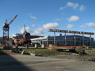
The Baltimore Museum of Industry is a museum in Baltimore, Maryland, United States. Located in an old cannery complex, the museum has exhibits on various types of manufacturing and industry from the early 20th century. There are several hands-on sections with working equipment and other artifacts.
The Chesapeake Beach Railway (CBR), now defunct, was an American railroad of southern Maryland and Washington, D.C., built in the 19th century. The CBR ran 27.629 miles from Washington, D.C., on tracks laid by the Southern Maryland Railroad and its own single track through Maryland farm country to a resort at Chesapeake Beach. The construction of the railway was overseen by Otto Mears, a Colorado railroad builder, who planned a shoreline resort with railroad service from Washington and Baltimore. It served Washington and Chesapeake Beach for almost 35 years, but closed amid the Great Depression and the rise of the automobile. The last train left the station on April 15, 1935. Parts of the right-of-way are now used for roads and a future rail trail.

The Washington, Baltimore and Annapolis Electric Railway (WB&A) was an American railroad that operated from 1899 until 1935 in central Maryland and Washington, D.C.

Baltimore is the most populous city in the U.S. state of Maryland. With a population of 585,708 at the 2020 census, it is the 30th-most populous US city. Baltimore was designated as an independent city by the Constitution of Maryland in 1851, and is the most populous independent city in the nation. As of 2020, the population of the Baltimore metropolitan area was 2,838,327, the 20th-largest metropolitan area in the country. The city is also part of the Washington–Baltimore combined statistical area (CSA), which had a 2020 population of 9,973,383, the third-largest in the country. Though Baltimore is not located within or under the administrative jurisdiction of any county in the state, it is part of the Central Maryland region, together with the surrounding county that shares its name.
Yale Heights is a neighborhood in the Southwest District of Baltimore, located between Beechfield (west) and Irvington (east). Most of its homes were built in 1955 as a development of two-bedroom, brick townhouses. These townhouses had an average value of $110,469 in 2022. The neighborhood's population in 2022 was estimated at 2,592.
Verizon Maryland LLC is Bell Operating Company owned by Verizon Communications serving the state of Maryland. Its headquarters are in Baltimore.

Irvington is a neighborhood in the Southwest District of Baltimore, located between Yale Heights neighborhood to the west and the Gwynns Falls neighborhood to the east. It was historically nicknamed "Skulltown" for its three large cemeteries: Loudon Park, Mount Olivet and New Cathedral.

Wheelabrator Baltimore, also known as WIN Waste Baltimore is a waste-to-energy incinerator located in the Westport neighborhood of Baltimore, Maryland, and is operated by Wheelabrator Technologies. It has an electric generation capacity of 64.5 megawatts. On October 2, 2018, ECP announced the agreement to sell Wheelabrator Technologies to Macquarie Infrastructure Partners, a subsidiary of Macquarie Group.

Hawkins Point is a neighborhood in the South District of Baltimore, located at the southern tip of the city between Curtis Bay (north) and the Anne Arundel County line (south) and Thoms Cove (east). Its land area covers 2.6 square miles (6.7 km2), and it had a population of 24 people according to the 2020 U.S. Census. The neighborhood is predominantly industrial.

The meat industry has been severely affected by the COVID-19 pandemic in the United States. Outbreaks of the virus took place in factories operated by the meat packing industry and the poultry processing industry. These outbreaks affected dozens of plants, leading to closures of some factories and disruption of others, and posed a significant threat to the meat supply in the United States. The damage the COVID-19 pandemic brought to the meatpacking industry was unexpected and resulted in a sharp reduction of meat processing and capacity reduction of meatpacking companies.


