
The Maryland Transit Administration (MTA) is a state-operated mass transit administration in Maryland, and is part of the Maryland Department of Transportation. The MTA operates a comprehensive transit system throughout the Washington-Baltimore metropolitan area. There are 80 bus lines serving the Baltimore Metropolitan Area, along with rail services that include the Light Rail, Metro Subway, and MARC Train. In 2023, the system had a ridership of 52,922,000, or about 219,600 per weekday as of the second quarter of 2024.

Mondawmin is a neighborhood located in the Western district of Baltimore, Maryland, United States. The neighborhood is surrounded by Druid Hill Park, the Whitelock Community, and Lower Park Heights. Included within its boundaries are Frederick Douglass High School, and Mondawmin Mall. The Baltimore Metro Subway serves the neighborhood, with a station at Mondawmin Mall that is also a hub for many bus routes.

Maryland Route 140 is a 49-mile (79 km) state highway in the U.S. state of Maryland. The route runs from U.S. Route 1 and US 40 Truck in Baltimore northwest to the Pennsylvania border, where the road continues into that state as Pennsylvania Route 16. MD 140 passes through the northern part of central Maryland, connecting Baltimore, Pikesville, Reisterstown, Westminster, Taneytown, and Emmitsburg.
Mondawmin refers to the following in Baltimore, Maryland, in the United States:

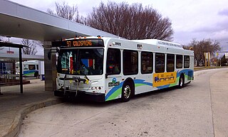
LocalLink 80 is a bus route operated by the Maryland Transit Administration in Baltimore, Maryland, in the United States. LocalLink 80 is part of the high frequency network of the local bus system. The route consists of a leg originating in Downtown Baltimore and goes on to serve the Garrison Boulevard corridor in the northwest of the city. Route 80 and its predecessor, route 91, has carried some of the highest ridership out of Baltimore's local bus network throughout its history. The line was the first in the city to be assigned articulated buses, which are now used to meet the higher capacity requirements of the frequent lines.

Mondawmin station is a Metro SubwayLink station in Baltimore, Maryland. It is located under the intersection of Reisterstown Road and Liberty Heights Avenue in the Mondawmin neighborhood, adjacent to the Mondawmin Mall. It is the northernmost underground station on the line, and a major transfer point to many bus routes.

The Maryland Transit Administration provides the primary public bus service for the Baltimore metropolitan area and commuter bus service in other parts of the state of Maryland. There are currently 76 bus routes, which include 45 LocalLink routes, 12 High Frequency CityLink Routes routes, 8 express bus routes, 19 commuter bus routes, and 5 Intercounty Connector or "ICC" routes. The local and commuter bus routes operate in conjunction with one subway line, three light rail lines, MARC train service, and various connections to other transit agencies.
Route 82, also known as the Mondawmin Shuttle Bug or Mondawmin Shuttle, is one of two neighborhood shuttle routes operated by the Maryland Transit Administration in Baltimore. It was the second and is so far the final in the series of shuttle bus routes to be introduced by MTA in the 2000s. The route serves Baltimore City Community College, Coppin State College, and various nearby streets, some served by regular bus routes, and some not. But the full route is within a close walk of one or more other MTA bus routes. The route operates at 25-minute intervals.
Dorchester is a neighborhood in the Northwest District of Baltimore. It is located between the neighborhoods of Arlington (north), Central Forest Park (south), Howard Park (west) and Gallway-Garrison (east). Maryland Route 26 draws the boundary between Dorchester and Central Forest Park. Dorchester's other boundaries are marked by Oakford Avenue, Eldorado Avenue and Garrison Boulevard.
Cameron Village is a neighborhood in the North District of Baltimore, located between the neighborhoods of Mid-Govans and Woodbourne Heights. Vaguely bell-shaped, its boundaries are marked by Bradhurst Road and E. Belvedere Avenue (north), Woodbourne Avenue (south), Lothian Road (west) and Northwood Drive (east).
Edgecomb, also known as Parklane, is a neighborhood in the North District of Baltimore, located between the neighborhoods of Cylburn (north) and Greenspring (south). Its boundaries are marked by Dupont Avenue (north), Coldspring Lane (south), Pimlico Road (west) and Greenspring Avenue (east). Central Park Heights, is located on the opposite side of Pimlico Road in the Northwest District. The neighborhood of Coldspring is located to Edgecomb's east, across Greenspring Avenue.

Cylburn is a neighborhood in the North District of Baltimore, located between the neighborhoods of Levindale (north) and Edgecomb (south). Its boundaries are marked by Cylburn Avenue (north), Dupont Avenue (south), Pimlico Road (west) and Greenspring Avenue (east). Central Park Heights, is located on the opposite side of Pimlico Road in the Northwest area of Baltimore City. Cylburn Arboretum and the neighborhood of Cold Spring are located to Cylburn's east, across Greenspring Avenue. The heavily wooded property with its historic mansion and grounds, walking trails, famous collections and gardens overlook the Jones Falls Valley with the Jones Falls Expressway further to the east.
Garwyn Oaks is a neighborhood in the Northwest District of Baltimore, located between the neighborhoods of Windsor Hills and Hanlon Longwood. The boundaries of its somewhat rectangular shape are marked by Woodhaven Avenue (north), Gwynns Falls Parkway (south), Garrison Boulevard (east) and Chelsea Terrace (west).
Greenspring is a neighborhood in the North District of Baltimore, located between the neighborhoods of Woodberry (east) and Central Park Heights (west). Its boundaries are marked by West Cold Spring Lane (north), Greenspring Avenue (east), and Springhill Avenue (south). The western edge of the neighborhood runs along Pimlico Road from West Cold Spring Lane to Park Heights Avenue, then along Park Heights Avenue to Springhill Avenue.

Beverly Hills is a neighborhood in the Northeast District of Baltimore, located between the neighborhoods of Moravia-Walther, Arcadia and Lauraville. Its boundaries are drawn by Harford Road (west), Weaver Avenue (south), Harcourt Road (east), Moravia Road (northeast) and Grindon Avenue (north).

Bellona–Gittings is a neighborhood in the North District of Baltimore, located between the neighborhoods of Cedarcroft (east) and The Orchards (west). Its boundaries are marked by the Baltimore County line (north), East Melrose Avenue (south), Bellona Avenue (east) and North Charles Street (west). Many of the houses in this neighborhood were built from 1853 to 1956, with a wide variety of styles. Aside from one historic commercial building, the neighborhood is residential.
Hanlon Longwood is a neighborhood in the Northwest District of Baltimore, located between the neighborhoods of Garwyn Oaks (west) and Burleigh–Leighton (east). It is bounded by North Dukeland Street (east), Garrison Boulevard (west) and the Gwynns Falls Parkway (south). The neighborhood's north boundary is marked by North Longwood Street, North Hilton Street and Liberty Heights Avenue.
Langston Hughes is a neighborhood in the Northwest District of Baltimore, located between the neighborhoods of Central Park Heights (east) and Woodmere. Its roughly pentagonal boundaries are marked by West Belvedere Avenue (northwest), Litchfield Avenue (northeast), Reisterstown Road (south) and Oakmont Avenue (east).
Westgate is a neighborhood in the Southwest District of Baltimore, located between Baltimore County (west) and the city neighborhood of Ten Hills (east). Its boundaries are marked by Baltimore National Pike (north), Frederick Avenue (south), Rock Glen Avenue and Edmondson Avenue (east) and the city line (west).
Mount Holly is a neighborhood in the Southwest District of Baltimore, located between the neighborhoods of Fairmont (south), Walbrook (east) and Garwyn Oaks (north). Its boundaries are drawn by Denison Street (east), Clifton Avenue (southwest), Gwynns Falls Parkway (north), Windsor Mill Road (northwest), and West North Avenue (south). Gwynns Falls Leakin Park is located to the west of Mount Holly.


