Bridgeview/Greenlawn is a historic, culturally diverse neighborhood in West Baltimore, Maryland. Originally a thriving center for Baltimore's middle class, it is noted for its multicultural American neighborhood, Jewish, Islamic, Catholic and Greek Orthodox traditions. In recent years, it has been included in Amtrak's Frederick Douglass Tunnel Program, which includes a modern ADA-accessible MARC station and a $50 million Community Investment Program.[1][2]
Bridgeview/Greenlawn is home to Eddie Murray Field at BGE Park, a modern community baseball facility opened in 2017. The field was developed through a partnership between the Cal Ripken Sr. Foundation, BGE, and Baltimore City Public Schools, and is named in honor of Baltimore native and Baseball Hall of Famer Eddie Murray. "Eddie Murray Field at BGE Park unveiled". Cal Ripken Sr. Foundation. November 15, 2017. Retrieved June 9, 2025.
Located at 1100 Wheeler Avenue, the field features a synthetic turf diamond, dugouts, bleachers, a backstop, and a digital scoreboard. It serves as the home field for the James Mosher Baseball League, one of the city's oldest African-American youth baseball leagues. "Eddie Murray Field at BGE Park - James Mosher Baseball League". Timmons Group. Retrieved June 9, 2025. Since its opening, the field has hosted after-school leagues, mentorship programs, and community events, including the Ripken Foundation's Badges for Baseball program, which combines sports with character education and mentoring. "Ripken Foundation: 2020 Annual Report". Cal Ripken Sr. Foundation. Retrieved June 9, 2025.
The park plays an important role in supporting youth recreation and community engagement in Bridgeview/Greenlawn and the surrounding neighborhoods.
Architecture and parks
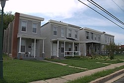
Bridgeview/Greenlawn is part of the Edmondson Avenue Historic District, which includes daylight rowhouses, Gothic-style churches, and early-to-mid 20th century civic buildings.[3] While it lacks large parks within its boundaries, the neighborhood benefits from proximity to Edmondson Village green space and is a short drive from Druid Hill Park, one of the oldest large landscaped urban parks in the U.S., notable for its Victorian-era design and historic architecture.[4]
History and culture
Bridgeview/Greenlawn was established as a streetcar suburb in the early to mid‑20th century and became a hub of Baltimore's middle class following rapid demographic shifts in the 1950s.[5][6]
The neighborhood is recognized for a diverse cultural landscape, including multicultural American heritage, Hebrew and Islamic expressions, Jewish, Catholic and Greek Orthodox influences. Community institutions—such as churches, mosques, and synagogues—have been integral to its spiritual life.
The late 20th century brought economic decline, housing abandonment, and public safety challenges, similar to other urban areas. Despite this, the community remains resilient, with ongoing efforts in interfaith cooperation, civic engagement, and cultural preservation.
Demographics
As of 2025, the neighborhood had an estimated population of about 3,000 residents.[7]
Infrastructure and revitalization
Bridgeview/Greenlawn lies along the alignment of the Frederick Douglass Tunnel Program, a $6 billion rail project led by Amtrak and scheduled for completion in 2035.[1] The project includes construction of two new electrified tunnel tubes and upgrades to Northeast Corridor rail infrastructure.[1] It will also replace the existing West Baltimore MARC Station with a modern, fully accessible facility.[1]
A $50 million Community Investment Program associated with the project supports local schools, businesses, parks, transportation improvements, workforce training, and historic preservation.[2] The program also includes a salvage centre that distributes reclaimed building materials from demolished homes to residents and community organizations.[8]
In 2014, the Coppin Heights Community Development Corporation secured control of a long-vacant building from Coppin State University and the University of Maryland. The transfer enabled a $12.4 million rehabilitation project to convert the building into the Center for Health Care and Healthy Living.[9] Restoration work carried out from 2018 to 2020 earned a Phoenix Award from Preservation Maryland in 2020 for excellence in historic preservation.[10]
The building reopened on October 25, 2023, as a community health centre. It now houses offices for the Baltimore City Health Department and Behavioral Health System Baltimore.[11]
Education
Bille Holliday Elementary School (2400 W Mosher St) serves Pre‑K–5 students from Bridgeview/Greenlawn.[12]
Sports and youth section
Added details on Eddie Murray Field at BGE Park, a youth baseball facility opened in 2017, supporting the James Mosher Baseball League and community mentorship programs. Sources include WMAR‑2, The Daily Record, MASN, and the Cal Ripken Sr. Foundation. Bridgeview/Greenlawn is home to Eddie Murray Field at BGE Park, a modern community baseball facility opened in 2017. The field was developed through a partnership between the Cal Ripken Sr. Foundation, BGE, and Baltimore City Public Schools, and is named in honor of Baltimore native and Baseball Hall of Famer Eddie Murray.[13]
Located at 1100 Wheeler Avenue, the field features a synthetic turf diamond, dugouts, bleachers, a backstop, and a digital scoreboard. It serves as the home field for the James Mosher Baseball League, one of the city's oldest African-American youth baseball leagues.[14] Since its opening, the field has hosted after-school leagues, mentorship programs, and community events, including the Ripken Foundation's Badges for Baseball program, which combines sports with character education and mentoring.[15]
The park plays an important role in supporting youth recreation and community engagement in Bridgeview/Greenlawn and the surrounding neighborhoods.
1234Amtrak, “Frederick Douglass Tunnel Program — Community Benefits & Infrastructure,” Amtrak.com, accessed June 2025.
12Amtrak, “Amtrak Publishes Guide for West Baltimore Community Investments Funded by the Frederick Douglass Tunnel Program,” April 2024. Amtrak, *Frederick Douglass Tunnel Program Community Investment Program Guide (PDF),* April 2024.
This page is based on this Wikipedia article Text is available under the CC BY-SA 4.0 license; additional terms may apply. Images, videos and audio are available under their respective licenses.