Harwood, Baltimore

Last updated
Harwood
"Welcome to Harwood" sign, E. 25th Street and Barclay Street (northeast corner), Baltimore, MD 21218 (33518885620).jpg
Harwood neighborhood welcome sign at Barclay and East 25th Streets
Country United States
State Maryland
City Baltimore
Time zone UTC-5 (Eastern)
  Summer (DST)EDT
ZIP code
21218
Area code 410, 443, and 667

Harwood is a small neighborhood located in the central area of Baltimore, Maryland, USA. It sits east of Charles Village, south of Abell, west of Waverly and north of Barclay. Its boundaries are Guilford and Greenmount Avenues to the east and west, and 25th and 29th streets to the north and south. These streets together encompass about 14 city blocks.

Contents

History

Harwood was originally known as Oxford. In the 1890s, the B&O Railroad constructed the Baltimore Belt Line through the neighborhood. The line was once the main passenger rail line into Baltimore from Philadelphia and New York, and now serves as a major freight route, with several trains passing through each day. The neighborhood's earliest homes were wood-frame detached houses, many of which are on 26th Street, next to the railroad tracks. The majority of homes are brick rowhouses, and most were built between 1900 and 1920.

Harwood was home to many of Baltimore's early professional baseball teams. The original Oriole Park, located at 25th Street and Greenmount Avenue, was home to Baltimore's professional team from 1882 to 1889. The team spent one season at a new ballpark four blocks north, at 29th Street and Greenmount Avenue in the Abell community, before returning to its first home, now christened Union Park, for the 1891 to 1900 seasons. After 1900, Baltimore baseball teams played most of their games at a new stadium at 30th Street and Greenmount Avenue, until Major League Baseball's Orioles began playing at nearby Memorial Stadium in 1954.

Demographics

According to the 2010 Census, Harwood has a population of about 1,575 people, a 12% decline since 2000. As of the census, 75% of residents are black, 21% are white, and 4% are of other races. Approximately 13% of the neighborhood's 749 houses were vacant as of the Census date. Harwood is a small community, encompassing just 45 acres, but has very little undeveloped space, and its population density is approximately 22,400 people per square mile. [1] The community's median household income is approximately $23,873. Approximately 40% of residents are homeowners with 60% of the neighborhood renting their home. As of 2010, the median home sale price in Harwood was $204,000. [2]

Community layout

Harwood consists primarily of brick rowhouses along mostly east-west streets. Barclay Street, a north-south thoroughfare the divides the neighborhood in half, also creates divisions in housing style. Most houses west of Barclay Street have large, covered porches, while most of those east of it boast only stoops. Homes fronting Guilford Avenue, on the neighborhood's western edge, tend to be larger and more expensive than most of the rest of the neighborhood. There are a few scattered businesses along the 25th Street and Greenmount Avenue boundaries of the community. The Baltimore Belt Line (a freight train line operated by CSX) runs below grade along 26th Street and creates noticeable noise and vibrations each time a train passes. Harwood has two small neighborhood parks and a community garden.

Transportation

As a dense urban neighborhood, many amenities are available in surrounding communities and are a short walk away. With a WalkScore of 91, Harwood is considered a "Walker's Paradise" by Walkscore.com. [3] According to the website, the neighborhood is the 15th "most walkable" neighborhood in Baltimore. Harwood is located on the 8 and 12 bus routes, operated by the Maryland Transit Administration, and is a couple blocks from the MTA's Red, Silver and 51 routes, as well as a shuttle operated by Johns Hopkins University. Guilford Avenue, Harwood's western boundary, is the city's only designated "bike boulevard," with traffic calming designed to encourage bicycling along the corridor, which connects Charles Village with the downtown area.

Revitalization

Harwood's population declined steadily in the latter half of the 20th century and early 21st century due to white flight, petty crime, drug dealing, drug abuse, and other social ills that negatively affected the neighborhood. However, several revitalization efforts are underway to help the community rebound. Harwood is part of Baltimore's Healthy Neighborhoods program, which offers special loans on designated target blocks within the community. Residents have won grants to complete substantial neighborhood beautification projects in recent years. One of the most notable projects includes mosaic house numbers, mailboxes and signs throughout the neighborhood. The community's main welcome sign, located at 25th Street and Barclay Street, is made of mosaics, as are the majority of house numbers on the 300 blocks of 26th Street, East Lorraine Avenue and 27th Street. The artist, who lives in Harwood, has also completed a decorative mosaic mural over the entrance to The Barclay School, one of the neighborhood's public schools, and most recently another large sign for the neighborhoods 29th Street Community Center.

Other small development projects are underway. In 2011 and 2012, 30 Harwood residents participated in the Charles Village Painted Ladies Contest, an occasional project to add vibrant color to the fronts of houses. [4] In 2012, an arts collective called Brickhaus was started on Greenmount Avenue, converting a vacant warehouse in 16 artist studios with exhibition and recording space. [5] In 2013, two developers who own a large number of vacant homes in the community were awarded a $500,000 grant from the State of Maryland to complete at least 18 renovations, mostly on Whitridge Avenue and East Lorraine Avenue. [6] Also in 2013, the City's former Barclay Recreation Center, which had been shuttered, was reopened as a community center. [7]

Schools

Harwood's public school students attend one of two public schools that serve the neighborhood, Margaret Brent Elementary/Middle School and The Barclay School. Both schools offer pre-Kindergarten through 8th grade education. Both schools are part of the Great Schools Charles Village initiative, a partnership between the two schools and Loyola University Maryland that seeks to create a stronger educational environment. The partnership works with Baltimore City Public Schools and advocacy groups like The Village Parents on issues like curriculum changes, parent engagement, enrollment and teacher training and retention.

Related Research Articles

<span class="mw-page-title-main">Baltimore Orioles (1882–1899)</span> 1882–1899 baseball team in Baltimore, Maryland, United States

The Baltimore Orioles were a 19th-century professional baseball team that competed from 1882 to 1899, first in the American Association and later in the National League. This early Orioles franchise, which featured six players and a manager who were later inducted to the National Baseball Hall of Fame, finished in first place for three consecutive seasons (1894–1896) and won the Temple Cup national championship series in 1896 and 1897.

<span class="mw-page-title-main">Charles Village, Baltimore</span> Neighborhood of Baltimore in Maryland, United States

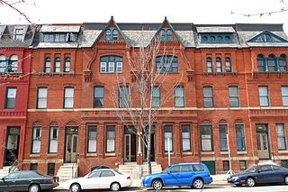
Charles Village is a neighborhood located in the north-central area of Baltimore, Maryland, USA. It is a diverse, eclectic, international, largely middle-class area with many single-family homes that is in proximity to many of Baltimore's cultural amenities. Nearby are the Baltimore Museum of Art, the Homewood campus of The Johns Hopkins University, Olmstead's Wyman Park, the weekly Waverly Farmers Market, and the arts district, Station North. Homes are Baltimore brick and stone row houses, many dating from the 1890s. Running from downtown north is the historic boulevard, Charles Street, where Baltimore's Easter Promenade once took place.

<span class="mw-page-title-main">Station North Arts and Entertainment District</span> Neighborhood of Baltimore in Maryland, United States

The Station North Arts and Entertainment District is an area and official arts and entertainment district in the U.S. city of Baltimore, Maryland. The neighborhood is marked by a combination of artistically-leaning commercial ventures, such as theaters and museums, as well as formerly abandoned warehouses that have since been converted into loft-style living. It is roughly triangular, bounded on the north by 20th Street, on the east by Greenmount Avenue, and on the south and west by the tracks of Amtrak's Northeast Corridor, though the neighborhood's boundaries include a one-block wide extension over the tracks.

<span class="mw-page-title-main">Abell, Baltimore</span> United States historic place

Abell is a neighborhood located in the north-central area of Baltimore, Maryland, United States. It is considered to be part of Charles Village, Baltimore.

<span class="mw-page-title-main">Charles Street (Baltimore)</span> State Highway in Maryland, US

Charles Street, known for most of its route as Maryland Route 139, runs through Baltimore and the Towson area of Baltimore County. On the north end, it terminates at an intersection with Bellona Avenue near Interstate 695 (I-695). At the south end, it terminates in Federal Hill in Baltimore. Charles Street is one of the major routes through Baltimore, and is a major public transportation corridor. For the one-way portions of Charles Street, the street is functionally complemented by the parallel St. Paul Street, including St. Paul Place and Preston Gardens, Maryland Avenue, Cathedral Street, and Liberty Street.

<span class="mw-page-title-main">CityLink Navy (BaltimoreLink)</span> Bus route operated by the Maryland Transit Administration

CityLink Navy is a bus route operated by the Maryland Transit Administration in Baltimore. It replaced Route 1 in 2017. The bus route is the successor to the 1 Gilmor Street, 2 Carey Street, and 2 Fort Avenue streetcar lines.

<span class="mw-page-title-main">Waverly, Baltimore</span> Neighborhood statistical area in Baltimore, Maryland, United States

Waverly is a neighborhood in the north central area of Baltimore, Maryland, located to the north of the adjacent same neighborhood called Better Waverly and west of Ednor Gardens-Lakeside, north and east of Charles Village west of the area of Coldstream-Homestead-Montebello neighborhoods, along with the campus of the former red brick H-shaped building for Eastern High School (1938–1984), facing north towards 33rd Street, now renovated since the 1990s into offices for The Johns Hopkins University, a mile to the west. Adjacent to the east of the Eastern High/Johns Hopkins campus is the landmark tree-shaded campus of The Baltimore City College, at 33rd Street and The Alameda. The College is a massive stone structure with a 150-foot bell tower visible for miles, nicknamed "The Castle on the Hill", constructed 1926–1928 of Collegiate Gothic architecture on one of the highest hills in the city, "Collegian Hill", with the downtown skyline visible to the south. City College is the third oldest public high school in America, founded 1839 in downtown has been through eight different sites in its 179 years of history and five major buildings, each were architectural landmarks in their times. From its beginnings, until 1979, it was a single sex secondary school for boys in the Baltimore City Public Schools, when it co-educated admitting young women. These three major institutions and their sports events dominated the east side of Waverly/Better Waverly for nine decades.

<span class="mw-page-title-main">Greenmount West, Baltimore</span> Neighborhood of Baltimore in Maryland, United States

Greenmount West is a neighborhood in the state-designated Station North Arts District of Baltimore. Its borders consist of Hargrove Alley to the west, Hoffman Street and the Amtrak railroad tracks to the south, the south side of North Avenue to the north, and Greenmount Avenue to the east. Residents in the area include a mix of low, middle and high income families, artists, commuters to Washington DC and working-class Baltimoreans with the majority of residents of African American descent.

<span class="mw-page-title-main">Barclay, Baltimore</span> Neighborhood of Baltimore in Maryland, United States

Barclay is a neighborhood in the center of Baltimore City. Its boundaries, as defined by the City Planning Office, are marked by North Avenue, Greenmount Avenue, Saint Paul and 25th Streets. The neighborhood lies north of Greenmount West, south of Charles Village, west of East Baltimore Midway, and east of Charles North and Old Goucher. The boundary between the Northern and Eastern police districts runs through the community, cutting it roughly in half.

<span class="mw-page-title-main">East Baltimore Midway, Baltimore</span> Neighborhood in Baltimore

East Baltimore Midway is a neighborhood in the Eastern district of Baltimore, Maryland. Its boundaries are the south side of 25th Street, the east side of Greenmount Avenue, the west side of Harford Road, and the north side of North Avenue.

<span class="mw-page-title-main">Guilford, Baltimore</span> United States historic place

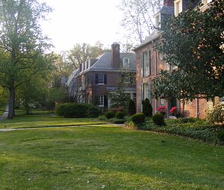
Guilford is a prominent and historic neighborhood located in the northern part of Baltimore, Maryland.

<span class="mw-page-title-main">Ednor Gardens-Lakeside, Baltimore</span> Community in Baltimore, Maryland

Ednor Gardens-Lakeside is a large community in northeast Baltimore, Maryland. It is bounded by 33rd Street to the south, Hillen Road to the east, Ellerslie Avenue to the west, and Argonne Drive, The Alameda, Loch Raven Boulevard, and Roundhill Road to the north. Ednor Gardens was part of a large planned community that was built out from the 1920s through the 1950s by Edward Gallagher, one of Baltimore's most prolific homebuilders at the time. It is notable among its neighbors for the quality of the homes and extensive landscaping. Until it was torn down in 2002, Memorial Stadium was located in Ednor Gardens-Lakeside.

<span class="mw-page-title-main">Pen Lucy, Baltimore</span> Neighborhood of Baltimore in Maryland, United States

Pen Lucy is a small community in the North District of Baltimore and part of the development of York Road, a historic Baltimore route to Pennsylvania. The Pen Lucy neighborhood features many different housing types.

<span class="mw-page-title-main">Remington, Baltimore</span> Neighborhood of Baltimore in Maryland, United States

Remington is a neighborhood in northern Baltimore bordered to the north by Hampden, Wyman Park, and Johns Hopkins University and to the east by Charles Village. The southernmost boundary is North Avenue and the long southwestern boundary is formed by Falls Road in the I-83 corridor. The neighborhood is split between two Baltimore City Council Districts.

<span class="mw-page-title-main">Oriole Park</span> Baseball stadium in Baltimore, Maryland

Oriole Park was the name of multiple baseball parks in Baltimore, Maryland, all built within a few blocks of each other.

<span class="mw-page-title-main">Patterson Park (neighborhood), Baltimore</span> United States historic place

Patterson Park is a neighborhood in Baltimore, Maryland, United States. Named for the 137-acre park that abuts its north and east sides, the neighborhood is in the southeast section of Baltimore city, roughly two miles east of Baltimore's downtown district.

Better Waverly is a neighborhood in the North District of Baltimore, located between the neighborhoods of Charles Village (west) and Coldstream-Homestead-Montebello (east). Its boundaries are marked by East 33rd Street (north), Exeter Hall Avenue (south), Greenmount Avenue (west) and Loch Raven Road (east).

<span class="mw-page-title-main">Midtown-Edmondson, Baltimore</span> Neighborhood of Baltimore in Maryland, United States

Midtown-Edmondson is a mixed-use neighborhood in western Baltimore City developed mostly between the 1880s and the 1910s. The neighborhood is mainly composed of residential rowhouses, with a mixed-used business district along Edmondson Avenue, and industrial warehouses and buildings dotted along the CSX railroads that bound its western edge.

References

  1. "Planning / 2010 Census". Baltimorecity.gov. 2014-04-28. Retrieved 2016-06-16.
  2. "GIS Mapping and Geographic Information System Data". PolicyMap.com. Retrieved 2016-06-16.
  3. "Harwood Baltimore Apartments for Rent and Rentals". Walkscore.com. Retrieved 2016-06-16.
  4. "Painted purple in Charles Village | GHCC". Archived from the original on 2013-07-04. Retrieved 2013-05-29.
  5. "Welcome Brickhaus.org - BlueHost.com". Brickhaus.org. Retrieved 2016-06-16.
  6. "BOE Agenda : Protests" (PDF). Baltimorecitycouncil.com. Archived from the original (PDF) on 2016-03-04. Retrieved 2016-06-16.
  7. Jacques Kelly (2013-02-17). "Volunteers work to reopen shuttered Barclay Rec Center - tribunedigital-baltimoresun". Articles.baltimoresun.com. Retrieved 2016-06-16.

39°19′12″N76°36′42″W / 39.3200°N 76.6117°W / 39.3200; -76.6117