Kresson, Baltimore

Last updated
Kresson
South Kresson St, Baltimore, MD 21224.jpg
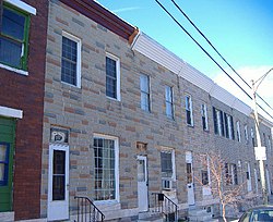
Rowhouses on South Kresson Street
Country United States
State Maryland
City Baltimore
Time zone UTC-5 (Eastern)
  Summer (DST)EDT
ZIP code
21224
Area code 410, 443, and 667

Kresson is a neighborhood of Southeast Baltimore, Maryland, United States. [1]

The area currently known as Kresson is primarily an industrial district, though a small section contains a residential neighborhood. Residents of Kresson often refer to their neighborhood as Highlandtown, a larger, adjacent residential neighborhood. Kresson's boundaries are defined by Pulaski Highway (U.S. Route 40) to the north, East Lombard and East Pratt Streets to the south, Haven Street (north and south portions) to the west and rail tracks to the east. [2]

The residential neighborhood in Kresson is architecturally, like much of Baltimore, composed of rowhouses. These row houses were constructed around the year 1900. The 2000 census determined its residents to be racially diverse, though predominantly lower-income. The neighborhood of 395 people was 75.9% white, and 20.3% African American. [3]

Kresson Street, which runs through the heart of the Kresson neighborhood, from East Lombard Street to East Monument Street (0.1 miles outside Kresson) is a section of MD 150. [4]

The north-south streets are arranged in consecutive order alphabetically, so to the west of Kresson lie Baylis, Conkling, Dean, Eaton, Fagley, Grundy, Haven, Iris and Janney, while those to the east are named Lehigh, Macon, Newkirk, Oldham, Ponca, Quail, Rappolla, Savage, Tolna and Umbra.

Related Research Articles

Wooster Square Neighborhood of New Haven in Connecticut, United States

Wooster Square is a neighborhood in the city of New Haven, Connecticut to the east of downtown. The name refers to a park square located between Greene Street, Wooster Place, Chapel Street and Academy Street in the center of the neighborhood. Wooster Square is also known as Little Italy: a bastion of Italian American culture and cuisine, and is home to some of New Haven's, best-known pizza eateries, including Frank Pepe Pizzeria Napoletana and Sally's Apizza. The square and much of the neighborhood are included in the Wooster Square Historic District, which was listed on the National Register of Historic Places in 1971.

The Schuylkill Expressway, locally known as "the Schuylkill" or "the Skook", is a two to eight lane freeway through southwestern Montgomery County and the city of Philadelphia, and the easternmost segment of Interstate 76 (I-76) in the U.S. state of Pennsylvania. It extends from the Valley Forge exit of the Pennsylvania Turnpike in King of Prussia, paralleling its namesake Schuylkill River for most of the route, to the Walt Whitman Bridge in South Philadelphia. It serves as the primary corridor into Philadelphia from points west. Maintenance and planning are administered through Pennsylvania Department of Transportation (PennDOT) District 6. Constructed over a period of ten years from 1949 to 1959, a large portion of the expressway predates the 1956 introduction of Interstate Highway System; many of these portions were not built to contemporary standards. The rugged terrain, limited riverfront space covered by the route and narrow spans of bridges passing over the highway have largely stymied later attempts to upgrade or widen the highway. With the road being highly over capacity, it has become notorious for its chronic congestion. An average of 163,000 vehicles use the road daily in Philadelphia County, and an average of 109,000 use the highway in Montgomery County, making it the busiest road in Pennsylvania. Its narrow lane and left shoulder configuration, left lane entrances and exits, common construction activity and generally congested conditions have led to many accidents, critical injuries and fatalities, leading to the highway's humorous nickname of the "Surekill Expressway" or in further embellishment, the "Surekill Distressway" or the “Surekill Crawlway".

Brewers Hill, Baltimore Neighborhood statistical area in Baltimore, Maryland, United States

Brewers Hill is a neighborhood in the Southeast District of Baltimore, Maryland, United States.

Maryland Route 150 State highway in, Maryland, US, known as Eastern Ave or Eastern Blvd

Maryland Route 150 (MD 150) is a state highway in the U.S. state of Maryland. Known for most of its length as either Eastern Avenue or Eastern Boulevard, the highway runs 13.01 miles (20.94 km) from U.S. Route 40 (US 40) in Baltimore east to Graces Quarters Road in Chase in eastern Baltimore County. MD 150 connects Baltimore with its southeastern suburbs of Dundalk, Essex, and Middle River. The state highway also links those communities with Interstate 95 (I-95), I-695, I-895, and Martin State Airport. MD 150 was constructed from Baltimore to Middle River and in Chase in the mid-1920s. The road was completed through Middle River in the early 1930s. Between 1942 and 1944, MD 150 was reconstructed as a four-lane divided highway with interchanges to improve access between Baltimore and the Glenn L. Martin Company aircraft manufacturing plant in Middle River. The highway has followed several routes since it was extended west into the city of Baltimore in the mid-1940s; the present route in East Baltimore was established shortly after 2000.

Charles Street (Baltimore) State Highway in Maryland, US

Charles Street, known for most of its route as Maryland Route 139, runs through Baltimore City and through the Towson area of Baltimore County. On the north end it terminates at an intersection with Bellona Avenue near Interstate 695 (I-695) and at the south end it terminates in Federal Hill in Baltimore. Charles Street is one of the major routes through the city of Baltimore, and is a major public transportation corridor. For the one-way portions of Charles Street, the street is functionally complemented by the parallel St. Paul Street, Maryland Avenue, Cathedral Street, and Liberty Street.


Amity is a residential and commercial neighborhood of the city of New Haven, Connecticut, United States. It is bounded on the northeast by West Rock Ridge, on the south by the Westville neighborhood of New Haven, and on the northwest by the Flats in the town of Woodbridge, Connecticut. The official New Haven neighborhood planning maps include the traditionally separate neighborhoods of West Hills and Beverly Hills within the Amity neighborhood. The neighborhood lies in the glacier-carved valley of the West River. The river flows in a southerly direction, bisecting the neighborhood.

Carrollton Ridge, Baltimore Neighborhood of Baltimore in Maryland, United States

Carrollton Ridge is a neighborhood of South Baltimore, Maryland, United States

U.S. Route 1 is a major north–south U.S. Highway, extending from Key West, Florida in the Florida Keys in the south to Fort Kent, Maine at the Canadian border in the north. In the U.S. state of Pennsylvania, US 1 runs for 81 miles (130 km) from the Maryland state line near Nottingham northeast to the New Jersey state line at the Delaware River in Morrisville, through the southeastern portion of the state. The route runs southwest to northeast, and serves as a major arterial road through the city of Philadelphia and for many of the suburbs in the Delaware Valley area. South of Philadelphia, the road mostly follows the alignment of the old Baltimore Pike. Within Philadelphia, it mostly follows Roosevelt Boulevard.

Randle Highlands Place in the United States

Randle Highlands is a neighborhood in Southeast Washington, D.C., east of the Anacostia River.

Perkins Homes, Baltimore Public housing development located in Baltimore, Maryland, United States

Perkins Homes is a public housing development in Southeast Baltimore, located between Fells Point and Little Italy and bounded by Pratt Street to the north, Eden Street on the west, Dallas Street on the east, and Bank Street to the south. The community is located within the East Harbor Empowerment Zone of the Fells Point area, and is one of the oldest housing projects in southeast Baltimore. The housing project tenants are about 91% African-American, 7% Puerto Rican, and 2% white.

U.S. Route 13 is a U.S. highway running from Fayetteville, North Carolina north to Morrisville, Pennsylvania. The route runs for 49.33 mi (79.39 km) through the Philadelphia metropolitan area in the U.S. state of Pennsylvania. The route enters the state from Delaware in Marcus Hook, Delaware County. It continues northeast through Delaware County, passing through the city of Chester before heading through suburban areas along Chester Pike to Darby. US 13 enters the city of Philadelphia on Baltimore Avenue and runs through West Philadelphia to University City, where it turns north along several city streets before heading east across the Schuylkill River along Girard Avenue. The route turns north and heads to North Philadelphia, where it runs northeast along Hunting Park Avenue. US 13 becomes concurrent with US 1 on Roosevelt Boulevard, continuing into Northeast Philadelphia. US 13 splits southeast on a one-way pair of streets before heading northeast out of the city on Frankford Avenue. The route continues into Bucks County as Bristol Pike, heading northeast to Bristol, where it turns into a divided highway. US 13 becomes a freeway in Tullytown and continues north to its terminus at US 1 in Falls Township, near Morrisville. US 13 roughly parallels Interstate 95 (I-95) through its course in Pennsylvania.

Brooklyn, Baltimore Neighborhood of Baltimore in Maryland, United States

Brooklyn is one of the southernmost neighborhoods in Baltimore, Maryland. It is located near Anne Arundel County along Governor Ritchie Highway which is also Maryland Route 2. Its main roads are South Hanover Street,, Potee Street, and East Patapsco Avenue, Sixth Street, Tenth Street, and West Bay Avenue which borders the neighboring Curtis Bay community to the east, running through Bay Brook Park, which separates the two. South Hanover Street also serves as the dividing line between east–west streets in Brooklyn, as Charles Street does not exist here. Often mistaken as Brooklyn Park, Brooklyn shares the 21225 ZIP Code with the greater Brooklyn Park area which is across the Baltimore City Line in and the other neighboring community of Cherry Hill to the west and northwest across the now small western branch of the Patapsco River flowing from Ellicott City and Elkridge and along the shoreline-hugging southern extension "South Hanover Street" of the downtown's old colonial-era "Hanover Street" across the 1914-1917 Hanover Street Bridge, later renamed the Vietnam Veterans Memorial Bridge in the 1990s.

Jonestown, Baltimore Neighborhood of Baltimore in Maryland, United States

Jonestown is a neighborhood in the southeastern district of Baltimore. Its boundaries are the north side of Pratt Street, the west side of Central Avenue, the east side of Fallsway, and the south side of Orleans Street. The neighborhood lies north of the Little Italy, south of the Old Town, west of the Washington Hill, and east of the Downtown Baltimore neighborhoods. The southern terminus of the Jones Falls Expressway is located here.

Pen Lucy, Baltimore Neighborhood of Baltimore in Maryland, United States

Pen Lucy is a small community in the North District of Baltimore and part of the development of York Road, a historic Baltimore route to Pennsylvania. The Pen Lucy neighborhood features many different housing types. The neighborhood is bounded by Argonne Drive (south), East 43rd Street (north), Greenmount Avenue (west) and The Alameda (east). The Pen Lucy Neighborhood Association, Inc., a non profit community organization represents the residents of the Pen Lucy Community.

Evergreen, Baltimore Neighborhood of Baltimore in Maryland, United States

Evergreen is a neighborhood in the North District of Baltimore, Maryland. Evergreen's buildings date from the late 19th to early 20th century. It is known as one of the first early non-rowhouse styled suburban communities in Baltimore.

Keswick is a residential neighborhood in Baltimore, Maryland. The area is mostly surrounded by, and sometimes considered a part of, the Roland Park neighborhood. It also borders the Evergreen neighborhood to the north and Guilford to the east. Keswick is delineated as south of West Cold Spring Lane, east of Kittery Lane, north of Overhill Road, and west of Stony Run stream.

Baltimore Highlands, Baltimore Neighborhood statistical area in Baltimore, Maryland, United States

Baltimore Highlands is a neighborhood in the Southeast District of Baltimore, located between the neighborhoods of Patterson Park and Kresson. Its boundaries are drawn by Pulaski Highway (north), East Baltimore Street (south), Haven Street (east) and North Clinton Street (west).

Harwood, Baltimore Neighborhood of Baltimore in Maryland, United States

Harwood is a small neighborhood located in the north-central area of Baltimore, Maryland, USA. It sits east of Charles Village, south of Abell, west of Waverly and north of Barclay. Its boundaries are Guilford and Greenmount Avenues to the east and west, and 25th and 29th streets to the north and south. These streets together encompass about 14 city blocks.

South Central is a neighborhood in Wichita, Kansas, United States. A mixed commercial and residential area on the east bank of the Arkansas River, it is among the city’s oldest neighborhoods.

References

  1. "Baltimore Neighborhoods - Southeast Planning District". Baltimore City Government. Archived from the original on 2007-02-16. Retrieved 2007-08-02.
  2. "Baltimore Neighborhood Map" (PDF). Live Baltimore Home Center, Inc. June 2005. Archived from the original (PDF) on 2007-09-27. Retrieved 2007-08-02.
  3. Baltimore City Department of Planning. "Table DP-1. Profile of General Demographic Characteristics: 2000, Neighborhood Statistical Area: KRESSON" (PDF). Baltimore Neighborhood Indicators Alliance. Archived from the original (PDF) on February 13, 2006. Retrieved 2007-08-02.
  4. Pruett, Mike. "MDRoads: Routes 140-159". Mike Pruett. Retrieved 2007-08-02.

Coordinates: 39°17′45″N76°33′29″W / 39.29583°N 76.55806°W / 39.29583; -76.55806