Penn-North, Baltimore

Last updated
Penn-North
Barber shop and vacant buildings, 1386-1394 W. North Avenue, Baltimore, MD 21217 (41099998954).jpg
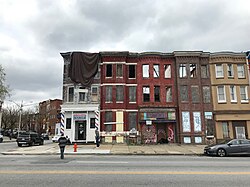
Buildings on the 1300 block of West North Avenue by the intersection with Woodbrook Avenue in Penn-North, Baltimore
Baltimore osm-mapnik location map.png
Red pog.svg
Penn-North
Location within Baltimore
USA Maryland relief location map.svg
Red pog.svg
Penn-North
Location within Maryland
Usa edcp relief location map.png
Red pog.svg
Penn-North
Location within the United States
Coordinates: 39°18′34″N76°38′38″W / 39.3094°N 76.6438°W / 39.3094; -76.6438 Coordinates: 39°18′34″N76°38′38″W / 39.3094°N 76.6438°W / 39.3094; -76.6438
Country Flag of the United States.svg  United States
State Flag of Maryland.svg  Maryland
City Flag of Baltimore, Maryland.svg Baltimore
City Council District 7
Time zone UTC−5 (Eastern)
  Summer (DST) UTC−4 (EDT)
ZIP Codes
21217
Area Codes 410, 443, 667
Penn-North, Baltimore

Penn-North is a neighborhood in the city of Baltimore, Maryland, United States. It is located southwest of Druid Hill Park, west of Reservoir Hill, north of Bolton Hill, and east of Mondawmin. It is bounded Northeast by the Druid Park Lake Drive, the West and Northwest by Fulton Ave., the South by North Avenue (U.S. Route 1), and East by McCulloh Street. It is contained in the 21217 ZIP code.

The neighborhood has a subway stop located at the corner of Pennsylvania Ave. and North Ave. [1] This is the Penn-North Metro Subway Station.

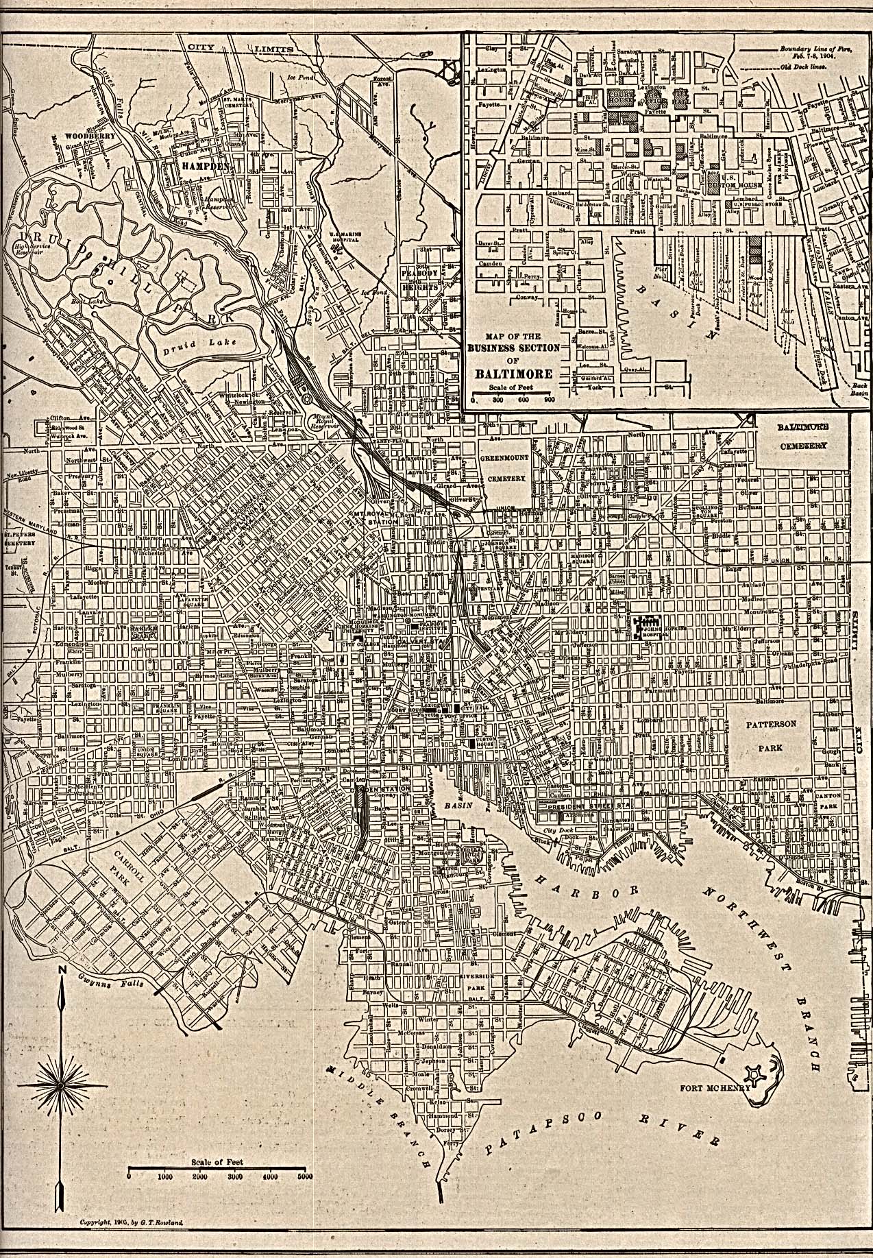
Some of the earliest records of the development of the area is the historical maps. One of these shows North Ave.'s intersection with Pennsylvania Ave. and the streets around it. [2] [3]

Proposed City Plans are available online. [4] [5] [6] [7]

Related Research Articles

Druid Hills, Georgia CDP and neighborhood of Atlanta in DeKalb, Georgia, United States

Druid Hills is a community which includes both a census-designated place (CDP) in unincorporated DeKalb County, Georgia, United States, as well as a neighborhood of the city of Atlanta. The CDP's population was 14,568 at the 2010 census. The CDP formerly contained the main campus of Emory University and the Centers for Disease Control and Prevention (CDC); they were annexed by Atlanta in 2018. The Atlanta-city section of Druid Hills is one of Atlanta's most affluent neighborhoods with a mean household income in excess of $238,500.

Maryland Transit Administration Public transit authority of the state of Maryland

The Maryland Transit Administration (MTA) is a state-operated mass transit administration in Maryland, and is part of the Maryland Department of Transportation. The MTA operates a comprehensive transit system throughout the Baltimore-Washington Metropolitan Area. There are 80 bus lines serving Baltimore's public transportation needs, along with other services that include the Light Rail, Metro Subway, and MARC Train. With nearly half the population of Baltimore residents lacking access to a car, the MTA is an important part of the regional transit picture. The system has many connections to other transit agencies of Central Maryland, Washington, D.C., Northern Virginia, and south-central Pennsylvania : WMATA, Charm City Circulator, Regional Transportation Agency of Central Maryland, Annapolis Transit, Rabbit Transit, Ride-On, and TransIT.

University City, Philadelphia Neighborhood of Philadelphia in Philadelphia County, Pennsylvania, United States

University City is the easternmost portion of West Philadelphia, encompassing several Philadelphia universities. It is situated directly across the Schuylkill River from Center City.

Druid Hill Park Urban park in northwest Baltimore, Maryland, US

Druid Hill Park is a 745-acre (3.01 km2) urban park in northwest Baltimore, Maryland. Its boundaries are marked by Druid Park Drive (north), Swann Drive and Reisterstown Road, and the Jones Falls Expressway / Interstate 83 (east).

Bolton Hill, Baltimore Neighborhood of Baltimore in Maryland, United States

Bolton Hill is a neighborhood in Baltimore, Maryland, with 20 blocks of mostly preserved buildings from the late 19th century. It is listed on the National Register of Historic Places, preserved as a Baltimore City Historic District, and included within the boundaries of Baltimore National Heritage Area. The neighborhood is bounded by North Avenue, Mount Royal Avenue, Cathedral Street, Dolphin Street, and Eutaw Place. Bolton Hill is a largely residential neighborhood with three-story row houses with red brick, white marble steps, and high ceilings. There are also larger more ornate originally single-family houses, many houses of worship, parks, monuments, and a few large apartment buildings. Many significant residents have lived in the neighborhood, including F. Scott Fitzgerald, Woodrow Wilson, the Cone sisters, and Florence Rena Sabin.

Mondawmin, Baltimore Neighborhood of Baltimore in Maryland, United States

Mondawmin is a neighborhood located in the city of Baltimore, Maryland, United States. The neighborhood is surrounded by Druid Hill Park, the Whitelock Community, and Lower Park Heights. Included within its boundaries are Frederick Douglass High School, and Mondawmin Mall. The Baltimore Metro Subway serves the neighborhood, with a station at Mondawmin Mall that is also a hub for many bus routes.

Baltimore Metro SubwayLink Rapid transit line in Maryland

The Metro SubwayLink is a rapid transit line serving the greater area of Baltimore, Maryland, in the United States, and is operated by the Maryland Transit Administration. Less than half of the line is underground, and most of the line outside the central city is elevated or at surface grade.

Baltimore Light RailLink Light rail transit system serving Baltimore

Baltimore Light RailLink is a light rail system serving Baltimore, Maryland, United States, as well as its surrounding suburbs. It is operated by the Maryland Transit Administration. In downtown Baltimore, it uses city streets. Outside the central portions of the city, the line is built on private rights-of-way, mostly from the defunct Northern Central Railway, Baltimore and Annapolis Railroad and Washington, Baltimore and Annapolis Electric Railway.

Reservoir Hill, Baltimore United States historic place

Reservoir Hill, also known as Whitelock, is a neighborhood in the city of Baltimore, Maryland, United States. It is located south of Druid Hill Park, north of Bolton Hill, east of Penn-North, and west of Jones Falls. It is bounded by Druid Park Lake Drive, the Jones Falls Expressway, North Avenue, and McCulloh Street. It is contained in the 21217 ZIP code.

Upton, Baltimore Neighborhood of Baltimore in Maryland, United States

Upton is a neighborhood in Baltimore City, Maryland, United States. The neighborhood is in the western section of the city, roughly between Fremont Avenue and McCulloh Street, extending from Dolphin Street to Bloom Street. Its principal thoroughfare is Pennsylvania Avenue.

Maryland Route 140 State highway in Maryland, US

Maryland Route 140 is a 49-mile (79 km) state highway in the U.S. state of Maryland. The route runs from U.S. Route 1 and US 40 Truck in Baltimore northwest to the Pennsylvania border, where the road continues into that state as Pennsylvania Route 16. MD 140 passes through the northern part of central Maryland, connecting Baltimore, Pikesville, Reisterstown, Westminster, Taneytown, and Emmitsburg.

LocalLink 80 (BaltimoreLink) Bus route in Baltimore, Maryland

LocalLink 80 is a bus route operated by the Maryland Transit Administration in Baltimore, Maryland, U.S.. LocalLink 80 is part of the high frequency network of the local bus system.

Park Heights, Baltimore Neighborhood of Baltimore in Maryland, United States

Park Heights is an area of Baltimore City, Maryland, that lies approximately 10 miles northwest of downtown Baltimore and within two miles of the Baltimore County line. A 1,500-acre community, Park Heights comprises 12 smaller neighborhoods that together contain approximately 30,000 residents. It is bounded on the south by Druid Park Drive, on the west by Wabash Avenue, on the east by Greenspring Avenue, and on the north by Northern Parkway. Interstate-83 is less than a half mile to the east. Two major roadways—Park Heights Avenue and Reisterstown Road—run north-south through Park Heights, serving as the neighborhood's "Main Streets" as well as commuter corridors. Limited commercial uses—primarily retail—are scattered along these roads; there is also some industrial activity on the neighborhood's western edge.

Maryland Route 129 State highway in Maryland, US

Maryland Route 129 is a state highway in the U.S. state of Maryland, running north-northwesterly from U.S. Route 40 and MD 295 in Baltimore into Baltimore County, ending at Garrison Forest Road east of Reisterstown. The route leaves downtown on the one-way pair of McCulloh Street and Druid Hill Avenue, and then uses the entire length of Park Heights Avenue to the end. MD 129 connects Downtown Baltimore with Druid Hill Park using McCulloh Street and Druid Hill Avenue. As Park Heights Avenue, the state highway is one of two primary radial routes in the northwestern part of the city, providing access to The Maryland Zoo and Pimlico Race Course. In Baltimore County, MD 129 passes through Pikesville, where it has a junction with Interstate 695 (I-695) and serves an affluent rural area north of Pikesville and east of Reisterstown.

Mondawmin station Metro SubwayLink station

Mondawmin station is a Metro SubwayLink station in Baltimore, Maryland. It is located under the intersection of Reisterstown Road and Liberty Heights Avenue in the Mondawmin neighborhood, adjacent to the Mondawmin Mall. It is the northernmost underground station on the line, and a major transfer point to many bus routes.

Rogers Avenue station Metro SubwayLink station

Rogers Avenue station is a Metro SubwayLink station in Baltimore, Maryland. It is located in the Woodmere area, and is the fifth most northern and western station on the line, with approximately 900 parking spaces.

Penn-North station Metro SubwayLink station

Penn-North station is a Metro SubwayLink station in Baltimore, Maryland. Its name comes from its location, at the corner of Pennsylvania and North Avenues. It is the eighth most northern and western station on the line, and the first station when starting from Owings Mills that does not have free parking.

Seton Hill, Baltimore United States historic place

Seton Hill Historic District is a historic district in Baltimore, Maryland. It was listed on the National Register of Historic Places in 1975.

Druid Heights, Baltimore Neighborhood in Baltimore

Druid Heights is a neighborhood in west Baltimore.

West Baltimore Innovation District Innovation district in Maryland, United States

The West Baltimore Innovation Village District is a neighborhood district of Baltimore City that will specialize in attracting startup companies and other employers to West Baltimore. Following the Death of Freddie Gray and the subsequent 2015 Baltimore protests, government leaders decided to launch the innovation district as a way to attract redevelopment and revitalization to the areas hardest hit by the protests. The district includes the neighborhoods of Mondawmin, Coppin Heights, Penn-North, Reservoir Hill and Bolton Hill.

References

  1. "Home | Maryland Transit Administration". Mta.maryland.gov. 2015-04-30. Retrieved 2015-05-06.
  2. "Photographic image of 1904 map of the Business Section of Baltimore" (JPG). Lib.utexas.edu. Retrieved 2015-05-06.
  3. "United States Historical City Maps – Perry–Castañeda Map Collection – UT Library Online". Lib.utexas.edu. Retrieved 2015-05-06.
  4. "Penn North Area Master Plan" (PDF). Archived from the original (PDF) on August 19, 2014. Retrieved August 19, 2014.
  5. "Planning / Master Plans, Maps & Publications / Neighborhood Plans". Archive.baltimorecity.gov. Retrieved 2015-05-06.
  6. "URBAN RENEWAL PLAN : PENN-NORTH TRANSIT STATION AREA" (PDF). Archive.baltimorecity.gov. Retrieved 2015-05-06.
  7. "Planning / Master Plans, Maps & Publications / Urban Renewal Plans". Archive.baltimorecity.gov. Retrieved 2015-05-06.