Madison Park | |
---|---|
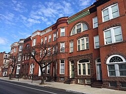
![]() Rowhouses on the northeast side of the 1800 block of McCulloh Street in Madison Park, Baltimore | |
Coordinates: 39°18′15″N76°37′40″W / 39.3041°N 76.6277°W | |
Country | ![]() |
State | ![]() |
City | ![]() |
City Council | District 11 |
Area | |
• Total | 0.1584 sq mi (0.410 km2) |
Population (2010) | |
• Total | 2,134 |
• Density | 13,474/sq mi (5,202/km2) |
[1] | |
Time zone | UTC−5 (Eastern) |
• Summer (DST) | UTC−4 (EDT) |
ZIP Codes | 21217, 21201 |
Area Codes | 410, 443, 667 |
![]() |
Madison Park is a neighborhood in west Baltimore.
Madison Park is bounded by North Avenue to the north, Martin Luther King Boulevard to the south, Eutaw Place and Dolphin Street to the east, and McCulloh Street and Madison Avenue to the west. Adjacent neighborhoods are Reservoir Hill (north), Mount Vernon (south), Seton Hill (south), Bolton Hill (east), Mid-Town Belvedere (east), Upton (west), and Druid Heights (west). [2]
Capitol Hill is a densely populated residential district and a neighborhood in Seattle, Washington, United States. It is immediately east of Downtown Seattle and north of First Hill. The neighborhood is one of the city's most popular nightlife and entertainment districts and is home to a historic gay village and vibrant counterculture community.
Manhattan Community Board 5 is a New York City community board, part of the local government apparatus of the city, with the responsibility for the neighborhoods of Midtown, Times Square, most of the Theater District, the Diamond District, the Garment District, Herald Square, Koreatown, NoMad, Murray Hill and the Flatiron District, all in the borough of Manhattan. It is bounded by 59th Street on the north, Eighth Avenue, 26th Street, the Avenue of the Americas on the west, 14th Street on the south, and Lexington Avenue on the east, excluding the area from 34th to 40th Streets between Madison and Lexington Avenues, and the area from 20th to 22nd Streets between Park Avenue South and Lexington Avenue/Irving Place.
Squire Park is a neighborhood in the city of Seattle, in the U.S. state of Washington. According to the Squire Park Community Council, it is bounded on the south by S. Jackson Street, on the west by 12th Avenue and 12th Avenue S., on the north by E. Union Street, and on the east by 23rd Avenue and 23rd Avenue S., placing it within the Central District. Its main thoroughfares are E. Jefferson and Cherry Streets and E. Yesler Way and 14th Avenue. Swedish Medical Center's Cherry Hill campus is located here, Seattle University, a Jesuit University has part of its campus in Squire Park, as the Admissions, some dormitories and Athletics departments are east of 12th Avenue.
Reservoir Hill is a historic neighborhood in the city of Baltimore, Maryland, United States. It is located south of Druid Hill Park, north of Bolton Hill, east of Penn-North, and west of Jones Falls. It is bounded by Druid Park Lake Drive, the Jones Falls Expressway, North Avenue, and McCulloh Street. It is contained in the 21217 ZIP code.
McElderry Park is a neighborhood in the northern part of the southeastern district of the City of Baltimore. Its boundaries are marked by East Fayette Street, East Monument Street, Linwood Avenue, and Patterson Park Avenue. South of McElderry Park is the neighborhood of Patterson Park; Butchers Hill is to the southwest. Ellwood Park is located to the east, and the campus of The Johns Hopkins Hospital to the west. To its north is the neighborhood of Madison-East End.
Charles Street, known for most of its route as Maryland Route 139, runs through Baltimore and the Towson area of Baltimore County. On the north end, it terminates at an intersection with Bellona Avenue near Interstate 695 (I-695). At the south end, it terminates in Federal Hill in Baltimore. Charles Street is one of the major routes through Baltimore, and is a major public transportation corridor. For the one-way portions of Charles Street, the street is functionally complemented by the parallel St. Paul Street, including St. Paul Place and Preston Gardens, Maryland Avenue, Cathedral Street, and Liberty Street.
Maryland Route 129 is a state highway in the U.S. state of Maryland, running north-northwesterly from U.S. Route 40 and MD 295 in the city of Baltimore into Baltimore County, ending at Garrison Forest Road east of Reisterstown. The route leaves downtown on the one-way pair of McCulloh Street and Druid Hill Avenue, and then uses the entire length of Park Heights Avenue to the end. MD 129 connects Downtown Baltimore with Druid Hill Park using McCulloh Street and Druid Hill Avenue. As Park Heights Avenue, the state highway is one of two primary radial routes in the northwestern part of the city, providing access to The Maryland Zoo and Pimlico Race Course. In Baltimore County, MD 129 passes through Pikesville, where it has a junction with Interstate 695 (I-695) and serves an affluent rural area north of Pikesville and east of Reisterstown.
Rose Hill is a neighborhood in the New York City borough of Manhattan, between the neighborhoods of Murray Hill to the north and Gramercy Park to the south, Kips Bay to the east, the Flatiron District to the southwest, and NoMad to the northwest. The formerly unnamed area is sometimes considered to be a part of NoMad, because the name "Rose Hill" was chiefly used for the area in the 18th and 19th centuries, and is not very commonly used to refer to the area in the 2010s.
Cherry Hill is a neighborhood and predominantly residential area in Seattle, Washington located south of Capitol Hill within the Central District, north of the International District, and east of First Hill. Cherry Hill is bound on the west by 14th Avenue, on the east by 23rd Avenue, on the north by East Madison Street and on the south by East Yesler Way. Cherry Hill overlaps considerably with the neighborhood of Squire Park as defined by the Squire Park Neighborhood Council. In the Seattle City Clerk's Geographic Indexing Atlas, Cherry Hill is designated as the Minor neighborhood of the Central Area. Cherry Hill was previously called Second Hill or Renton Hill.
Waverly is a neighborhood in the north central area of Baltimore, Maryland, located to the north of the adjacent same neighborhood called Better Waverly and west of Ednor Gardens-Lakeside, north and east of Charles Village west of the area of Coldstream-Homestead-Montebello neighborhoods, along with the campus of the former red brick H-shaped building for Eastern High School (1938–1984), facing north towards 33rd Street, now renovated since the 1990s into offices for The Johns Hopkins University, a mile to the west. Adjacent to the east of the Eastern High/Johns Hopkins campus is the landmark tree-shaded campus of The Baltimore City College, at 33rd Street and The Alameda. The College is a massive stone structure with a 150-foot bell tower visible for miles, nicknamed "The Castle on the Hill", constructed 1926–1928 of Collegiate Gothic architecture on one of the highest hills in the city, "Collegian Hill", with the downtown skyline visible to the south. City College is the third oldest public high school in America, founded 1839 in downtown has been through eight different sites in its 179 years of history and five major buildings, each were architectural landmarks in their times. From its beginnings, until 1979, it was a single sex secondary school for boys in the Baltimore City Public Schools, when it co-educated admitting young women. These three major institutions and their sports events dominated the east side of Waverly/Better Waverly for nine decades.
NoMad, also known as Madison Square North, is a neighborhood centered on the Madison Square North Historic District in the borough of Manhattan in New York City.
Frankford is a neighborhood in northeast Baltimore. Frankford is the most populous of the city's designated neighborhoods, with over 17,000 residents.
Druid Heights is a neighborhood in west Baltimore.
Jones Falls Trail is a hiking and bicycling trail in Baltimore, Maryland. It mostly runs along the length of the namesake Jones Falls, a major north–south stream in and north of the city that has long acted as a major transportation corridor for the city. It also incorporates the bike path encircling Druid Hill Reservoir and its namesake park. The Jones Falls Trail forms a segment of the East Coast Greenway, a partially completed network of off-road bicycling routes that runs the length of the East Coast.
Broadway is a major north–south thoroughfare in Seattle, Washington. The 1.6-mile-long (2.6 km) arterial runs north from Yesler Way at Yesler Terrace through the First Hill and Capitol Hill neighborhoods to East Roy Street. Broadway East continues north to East Highland Drive. North of there the street is made up of shorter segments: one from just south of East Blaine Street to just north of East Miller Street, another from East Roanoke Street to East Shelby Street, and the last from East Allison Street to Fuhrman Avenue East.
Midtown South is a macro-neighborhood of the borough of Manhattan in New York City, generally characterized as constituting the southern portion of Midtown Manhattan. Midtown Manhattan hosts over 700,000 daily employees as a busy hub for workers, residents, and tourists. The Empire State Building, the Flatiron Building, Pennsylvania Station, Madison Square Garden, the Macy's Herald Square flagship store, Koreatown, and NYU Langone Medical Center are all located in Midtown South.
Madison-Eastend is a neighborhood in the heart of East Baltimore, Maryland. Madison-Eastend occupies 66.7 acres of land north of Patterson Park and south of Amtrak's Northeast Corridor. The neighborhood is bounded by the neighborhoods of Ellwood Park and McElderry Park to the south, Milton-Montford to the west, Biddle Street to the north, and Orangeville to the east. The swath of land between Johns Hopkins Hospital and Frank C Bocek Park, which includes Madison-Eastend, is often referred to as the "Down the Hill" neighborhood by local residents.