The English word "fell" comes from Old Norsefell and fjall (both forms existed).[1] It is cognate with Danishfjeld, Faroesefjall and fjøll, Icelandicfjall and fell, Norwegianfjell with dialectsfjøll, fjødd, fjedd, fjedl, fjill, fil(l), and fel,[2] and Swedishfjäll, all referring to mountains rising above the alpine tree line.[3]
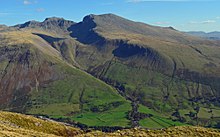
View of the Scafell massif from Yewbarrow, Wasdale, Cumbria. In the valley are older enclosures and higher up on the fell-side are the parliamentary enclosures following straight lines regardless of terrain.
In northern England, especially in the Lake District and in the PennineDales, the word "fell" originally referred to an area of uncultivated high ground used as common grazing usually on common land and above the timberline. Today, generally, "fell" refers to the mountains and hills of the Lake District and the Pennine Dales.
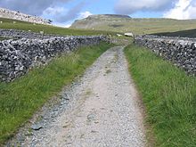
Names that originally referred to grazing areas have been applied to these hilltops. This is the case with Seathwaite Fell, for example, which would be the common grazing land used by the farmers of Seathwaite. The fellgate marks the road from a settlement onto the fell (see photograph for example), as is the case with the Seathwaite Fell. In other cases the reverse is true; for instance, the name of Wetherlam, in the Coniston Fells, though understood to refer to the mountain as a whole, strictly speaking refers to the summit; the slopes have names such as Tilberthwaite High Fell, Low Fell and Above Beck Fells.
Fell Lane, near Ingleton towards the fellgate and Ingleborough, North Yorkshire, England
As the most mountainous region of England, the Lake District is the area most closely associated with the sport of fell running, which takes its name from the fells of the district. "Fellwalking" is also the term used locally for the activity known in the rest of Great Britain as hillwalking.
The word "fell" also enjoys limited use in Scotland; with, for example, the Campsie Fells in central Scotland, to the north-east of Glasgow. One of the most famous examples of the use of the word "fell" in Scotland is Goat Fell, the highest point on the Isle of Arran. Criffel and the nearby Long Fell in Galloway may be seen from the northern Lake District of England. Peel Fell in the Kielder Forest is on the border between the Scottish Borders to the north and the English county of Northumberland to the south.
In Norway, fjell, in common usage, is generally interpreted as simply a summit or area of greater altitude than a hill, which leads to a great deal of local variation in what is defined as a fjell. Fjell is mostly used about areas above the forest line. Distinct summits can be referred to as et fjell (a mountain). High plateaus (vidde landscape) such as Hardangervidda are also regarded as fjell.[4][5] Professor of geography at the University of Bergen, Anders Lundeberg, has summed up the problem by stating, "There simply is no fixed and unambiguous definition of fjell."[6]Ivar Aasen defined fjell as a "tall berg", primarily referring to a berg that reaches an altitude where trees do not grow, lower berg are referred to as "berg", ås (hill, ridge) or hei (moor, heathland). The fixed expression til fjells refers to mountains (or uplands) as a collective rather than a specific location or specific summit (the "s" in til fjells is an old genitive form remaining only in fixed expressions). According to Ivar Aasen, berg refers to cliffs, bedrock and notable elevations of the surface underpinned by bedrock; berg also refers to the substance of bedrock.[7][8] For all practical purposes, fjell can be translated as "mountain" and the Norwegian language has no other commonly used word for mountain.[citation needed]
Sweden
In Sweden, fjäll generally refers to any mountain or upland high enough that forest will not naturally survive at the top, in effect a mountain tundra. Fjäll is primarily used to describe mountains in the Nordic countries, but also more generally to describe mountains shaped by massive ice sheets, primarily in Arctic and subarctic regions. There are however dialectal differences in usage, with comparatively low mountains or plateaus, sometimes tree-covered, in Bohuslän and Västergötland (e.g. Safjällets nationalpark[sv] and Kynnefjäll[sv]) being referred to as "fjäll", similar to how the word is used in Norwegian [citation needed]
Finland
Fells in Finland (including Halti, the highest fell in Finland)
In Finnish, the mountains characteristic of the region of Lapland are called tunturi (plural: tunturit), i.e. "fell". A tunturi is a hill high enough that its top is above the tree line and has alpine tundra. In Finnish, the geographical term vuori is used for mountains recently uplifted and with jagged terrain featuring permanent glaciers, while tunturi refers to the old, highly eroded, gently shaped terrain without glaciers, as found in Finland.[9] They are round inselbergs rising from the otherwise flat surroundings. The tree line can be at a rather low altitude, such as 600 m in Enontekiö, owing to the high latitude. The fells in Finnish Lapland form vestiges of the Karelides mountains, formed two billion years ago. The term tunturi is also generally used to refer to treeless plains at high altitudes in far north regions. The term tunturi, originally a word limited to far-Northern dialects of Finnish and Karelian, is a loan from Sami, compare Proto-Sami*tuontër, South Samidoedtere, Northern Samiduottar, Inari Samituodâr "uplands, mountains, tundra", Kildin Samitūndâr, which means "uplands, treeless mountain tract" and is cognate with Finnish tanner "hard ground".[10] From this Sami word, the word "tundra" is borrowed, as well, through the Russian language.[11][12] Hills that are over 50 m high, but do not reach the tree line are referred to as vaara, while the general term for hills including hills of 50 m or less is mäki.[13] In place names, however, tunturi, vaara and vuori are used inconsistently, e.g. Rukatunturi is technically a vaara, as it lacks alpine tundra.[citation needed]
The term förfjäll (literally "fore-fell") is used in Sweden and Finland[14] to denote mountainous zones lower and less dissected than the fell proper. However, its more pronounced relief, its often higher amount of plateaux, and its coherent valley systems distinguishes the förfjäll also from the undulating hilly terrain (bergkullsterräng) and the plains with residual hills (bergkullslätt). Generally, the förfjäll do not surpass 1000m ASL. As a geomorphic unit, the förfjäll extends across Sweden as a 650km-long and 40km to 80km-broad belt from Dalarna in the south to Norrbotten in the north.[15]
This page is based on this Wikipedia article Text is available under the CC BY-SA 4.0 license; additional terms may apply. Images, videos and audio are available under their respective licenses.