
The Pennines, also known as the Pennine Chain or Pennine Hills, are a range of uplands mainly located in Northern England. Commonly described as the "backbone of England" because of its length and position, the range runs from Derbyshire and Staffordshire in the north of the Midlands to Northumberland in North East England. From the Tyne Gap in the north, the range extends south through the North Pennines, Yorkshire Dales, South Pennines, and Peak District to end near the valley of the River Trent. The Border Moors and Cheviot Hills, which lie beyond the Tyne Gap, are included in some definitions of the range.

A fell is a high and barren landscape feature, such as a mountain or moor-covered hill. The term is most often employed in Fennoscandia, Iceland, the Isle of Man, parts of northern England, and Scotland.
The mountains of Whernside, Ingleborough and Pen-y-ghent are collectively known as the Three Peaks. The peaks, which form part of the Pennine range, encircle the head of the valley of the River Ribble in the Yorkshire Dales National Park in the North of England.
Ingleborough is the second-highest mountain in the Yorkshire Dales, England. It is one of the Yorkshire Three Peaks, and is frequently climbed as part of the Three Peaks walk. A large part of Ingleborough is designated as a Site of Special Scientific Interest and National Nature Reserve and is the home of a joint project, Wild Ingleborough, with aims to improve the landscape for wildlife and people.

Fairfield is a fell in the English Lake District. It is the highest of a group of hills in the Eastern Fells, standing to the south of the Helvellyn range.

Grasmoor is a mountain in the north-western part of the Lake District, northern England. It is the highest peak in a group of hills between the villages of Lorton, Braithwaite and Buttermere, and overlooks Crummock Water.

High Seat is a fell in the dale of Mallerstang, Cumbria. With a summit at 709 metres (2,326 ft), it is the fourth highest fell in the Yorkshire Dales after Whernside, Ingleborough and Great Shunner Fell. It is in the north-western part of the Dales, overlooking the deep trench of Mallerstang, and is usually climbed from this side.

The Pennine Bridleway is a National Trail in Northern England.

Aisgill is the southernmost of the hamlets that form the parish of Mallerstang in the English county of Cumbria. It is on the B6259 road, at the head of Mallerstang dale, just before the boundary between Cumbria and North Yorkshire.

Mallerstang is a civil parish in the extreme east of Cumbria, and, geographically, a dale at the head of the upper Eden Valley. Originally part of Westmorland, it lies about 6 miles (9.7 km) south of the nearest town, Kirkby Stephen. Its eastern edge, at Aisgill, borders on North Yorkshire; and since August 2016 it has been within the Yorkshire Dales National Park.

Millstone Grit is any of a number of coarse-grained sandstones of Carboniferous age which occur in the British Isles. The name derives from its use in earlier times as a source of millstones for use principally in watermills. Geologists refer to the whole suite of rocks that encompass the individual limestone beds and the intervening mudstones as the Millstone Grit Group. The term Millstone Grit Series was formerly used to refer to the rocks now included within the Millstone Grit Group together with the underlying Edale Shale Group.

Nine Standards Rigg is the summit of Hartley Fell in the Pennine Hills of England. It lies near the boundary between Cumbria and North Yorkshire, a few miles south-east of Kirkby Stephen and approximately 770 yards (700 m) outside the Yorkshire Dales National Park. Nine Standards Rigg lies within the North Pennines Area of Outstanding Natural Beauty (AONB). The name is derived from a group of cairns, the Nine Standards, located near the summit. The fell is listed as Nine Standards Rigg, rather than Hartley Fell, in Alan Dawson's book The Hewitts and Marilyns of England.

Baugh Fell is a large, flat-topped hill in the northern Pennines of England. It lies in the north-western corner of the Yorkshire Dales National Park, immediately to the east of the Howgill Fells and to the north of Whernside, the highest of the Yorkshire Three Peaks. Formerly in the West Riding of Yorkshire, since 1974 it has been part of the county of Cumbria.

The mountains and hills of England comprise very different kinds of terrain, from a mountain range which reaches almost 1,000 metres high, to several smaller areas of lower mountains, foothills and sea cliffs. Most of the major upland areas have been designated as Areas of Outstanding Natural Beauty (AONB) or national parks. The highest and most extensive areas are in the north and west, while the midlands, south-east and east of the country tend to be low-lying.

Top o'Selside is a hill in the Lake District in Cumbria, England. At 335 metres (1,099 ft), it is the highest point of the group of hills situated between Coniston Water and Windermere. This group also includes the Wainwright of Black Fell and the summits of Black Brows and Rusland Heights. Top o'Selside lies not in the centre of this region, but in the south-western corner, just outside the forestry plantations of Grizedale Forest and only two-thirds of a mile from the eastern shore of Coniston Water. This large separation from any higher ground gives it enough relative height to make it a Marilyn.

The South Pennines is a region of moorland and hill country in northern England lying towards the southern end of the Pennines. In the west it includes the Rossendale Valley and the West Pennine Moors. It is bounded by the Greater Manchester conurbation in the west and the Bowland Fells and Yorkshire Dales to the north. To the east it is fringed by the towns of West Yorkshire whilst to the south it is bounded by the Peak District. The rural South Pennine Moors constitutes both a Site of Special Scientific Interest and Special Area of Conservation.

Hugh Seat is a mountain, or more accurately a fell, in Mallerstang on the eastern edge of Cumbria, England. It lies on the border between Cumbria and North Yorkshire.

Swarth Fell is an approximately 1-mile (1.6 km) stretch of high ground situated to the south of Wild Boar Fell, of which it is a continuation. It is mostly within Mallerstang, Cumbria, but the boundary between Cumbria and North Yorkshire runs along its length, just to the west of the highest points.

Gregory Chapel is one of the high points of the fells on the border between Cumbria and North Yorkshire.

Fountains Fell is a mountain in the Yorkshire Dales, England. The main summit has a height of 668 metres (2,192 ft) and a relative height or topographic prominence of 243 metres (797 ft) and thus qualifies as a Marilyn. Its subsidiary, Fountains Fell South Top reaches 662 metres (2,172 ft) and qualifies as a Nuttall. A third summit, further south at SD868697, reaches 610 metres (2,001 ft) and is the most southerly 2,000 ft summit in the Pennines.
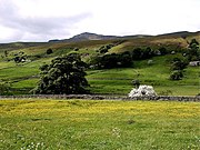 Wild Boar Fell, seen from Mallerstang in June, with wild flowers in the hay meadows
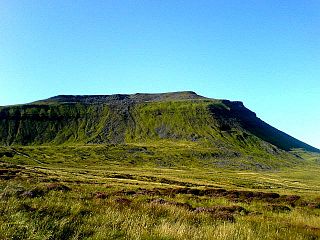
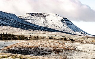
 The table top profile of Wild Boar Fell, from Aisgill
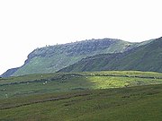 The Nab, Wild Boar Fell
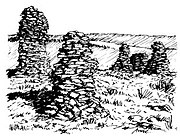 Cairns on The Nab, Wild Boar Fell


