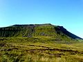
The landscape of the Yorkshire Dales consists of sheltered glacial valleys separated by exposed moorland.[2] The predominant rock is Carboniferous Limestone, which is particularly visible in the south-west in features such as Malham Cove. It is overlain in many areas by the Yoredale Series of alternating weak shales and hard limestones and sandstones, which give the dales their characteristic 'stepped' appearance.[3] Most of the dales contain rivers, and the area contains seven primary catchments: the Swale, Ure, Wharfe, Aire, Nidd, Ribble, and Lune.[4] There are several notable cave systems in the area, including part of the longest system in the United Kingdom, the Three Counties.[5]
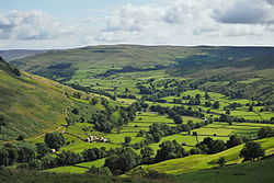
Agriculture and other land management has significantly affected the appearance of the Dales, through the creation of pastures and meadows for livestock grazing and moorland for red grouse shooting. Dry stone walls and field barns are characteristic of the valley floors, particularly Wensleydale and Swaledale in the north.[2]Wensleydale cheese is a particularly famous product from the region.[2] The dales are popular for hiking, and are crossed by the Dales Way, Pennine Way, and Coast to Coastlong-distance footpaths.[6][7] The Yorkshire Three Peaks is a walking trail entirely within the area which takes in three of its mountains: Ingleborough (723m (2,372ft)), Whernside (736m (2,415ft)), and Pen-y-ghent (694m (2,277ft)).[8] The extensive cave systems are a major centre for caving in the UK.[9]
Etymology
The word dale, like dell, is derived from the Old English word dæl. It has cognates in the Nordic/Germanic words for valley (dal, tal), and occurs in valley names across Yorkshire and Northern England.[10] Usage here may have been reinforced by Nordic languages during the time of the Danelaw.[11]
Most of the dales are named after their river or stream (e.g., Arkengarthdale, formed by Arkle Beck). The best-known exception is Wensleydale, which is named after the small village and former market town of Wensley, rather than the River Ure, although an older name for the dale is Yoredale.[12] River valleys all over Yorkshire are called "(name of river)+dale"—but only the more northern valleys (and only the upper, rural, reaches) are included in the term "The Dales".[13]
The lower reaches of Airedale and Wharfedale are not usually included in the area, and Calderdale, south of Airedale and in the South Pennines, is not often considered part of the Dales (even though it is a dale, is in Yorkshire, and its upper reaches are as scenic and rural as many further north).[15] Additionally, although the National Park includes the Howgill Fells and Orton Fells,[16] they are not usually considered part of the Dales.
The characteristic scenery of the Dales is green upland pastures separated by dry-stone walls and grazed by sheep and cattle.[19] A survey carried out in 1988 estimated that there were just over 4,971 miles (8,000km) of dry-stone walling in the Yorkshire Dales.[20] Many upland areas consist of heather moorland, used for grouse shooting from 12 August (the Glorious Twelfth).[21]
The Yorkshire Dales National Park covers 2,178 km2 (841 sq mi) and includes most of the dales as well as the Howgill Fells, and the Orton Fells. Most of the park is within North Yorkshire, with a sizeable area in Cumbria and a small part in Lancashire. Nidderdale is not within the national park, and has instead been designated a national landscape.
Cultural aspects
A typical village (Gunnerside) in the Swaledale agricultural area of the Yorkshire DalesTourists approaching a field barn in Muker
Much of the rural area is used for agriculture, with residents living in small villages and hamlets or in farmsteads. Miles of dry-stone walls and much of the traditional architecture have remained,[22] including some field barns, though many are no longer in active use. Breeding of sheep and rearing of cattle remain common.[23] To supplement their incomes, many farmers have diversified, with some providing accommodations for tourists.[24] A number of agricultural shows are held each year.[25]
Lead mining was common in some areas of the Dales in the 19th century, particularly during 1821 to 1861, and some industrial remains can still be found, such as the Grassington miners' cottages.[26] Certain former mining sites are maintained by Historic England. The Grassington Moor Lead Mining Trail, with its many remaining structures,[27] has received funding from a variety of sources. The Yorkshire Dales National Park Authority provides a mobile-device software app for those who wish to explore the relevant areas.[28]
Tourism
In this primarily agricultural area, tourism has become an important contributor to the economy.[29] In 2016, there were 3.8 million visits to the Yorkshire Dales National Park including 0.48 million who stayed at least one night. The park authority estimates that this contributed £252 million to the economy and provided 3,583 full-time equivalent jobs. The wider Yorkshire Dales area received 9.7 million visitors who contributed £644 million to the economy.[30]
A traditional pub with rooms to let in Hawes, in the Dales of North Yorkshire
The 73-mile-long (117km)Settle–Carlisle line railway, operated by Network Rail, runs through the National Park using tunnels and viaducts, including Ribblehead.[33]
The DalesBus service provides service in the Dales on certain days in summer, "including the Yorkshire Dales National Park and Nidderdale Area of Outstanding Natural Beauty". In summer, these buses supplement the other services operating year-round in the Dales.[35][36]
Tourism in the region declined because of restrictions implemented in relation to the COVID-19 pandemic in 2020, and into 2021. Later in 2021, the volume of visits was expected to increase as a result of the 2020 TV series All Creatures Great and Small, largely filmed within the Dales.[37] The first series aired in the UK in September 2020 and in the US in early 2021. One source stated that visits to Yorkshire websites had increased significantly by late September 2020.[38] By early 2021, the Discover England websites, for example, were using the tagline "Discover 'All Creatures Great and Small' in Yorkshire".[39]
The underlying limestone in parts of the Dales has extensive cave systems, including the 54-mile-long (87km)Three Counties System, making it a major area for caving in the UK. There are over 2500 known caves;[45] some are open to the public for tours.[46] Visitors can try caving at one of the show caves: White Scar Cave, Ingleborough Cave or Stump Cross Caverns near Greenhow.[47]
↑ "Get Outdoors". Yorkshire Dales. 1 March 2016. Retrieved 12 January 2019. There are over 2500 known caves in the Dales including the longest system in Britain
↑ Ekwall, Eilert (1960). The concise Oxford dictionary of English place-names (4ed.). Oxford: Oxford University Press. p.138. OCLC1228215388.
↑ Booth, Michael (2015). "Introduction". The Almost Nearly Perfect People (1ed.). London: Vintage Books. p.9. ISBN9780099546078.
↑ Rhea, Nicholas (5 November 2010). "Why call it Wensleydale?". Darlington and Stockton Times. Retrieved 10 April 2018.
↑ Chrystal, Paul (2017). The Place Names of Yorkshire; Cities, Towns, Villages, Rivers and Dales, some Pubs too, in Praise of Yorkshire Ales (1ed.). Catrine: Stenlake. pp.102–104. ISBN9781840337532.
↑ "Caving". Yorkshire Dales National Park. Retrieved 25 November 2022. There are over 2500 known caves in the Dales including the longest system in Britain
This page is based on this Wikipedia article Text is available under the CC BY-SA 4.0 license; additional terms may apply. Images, videos and audio are available under their respective licenses.