In 1986 Mary Towneley rode on horseback 250 miles (402km) from Corbridge, Northumberland, to Ashbourne, Derbyshire, to launch the idea of a Pennine Bridleway. This was followed by a feasibility study and route investigation from 1987 to 1990. Finally in 1995 approval was granted for the Pennine Bridleway National Trail from Carsington Water, Derbyshire, to Kirkby Stephen, Cumbria.
In 1999 Sport England awarded and donated £1,841,876 towards the route from Derbyshire to North Yorkshire and 3 feeder routes from Keighley, Bolton and Penistone. The Pennine Bridleway project team was appointed by the Countryside Agency and work began shortly.
In 2000 there was a proposal for an extension to the Pennine Bridleway from Kirkby Stephen, Cumbria, to Byrness, Northumberland. This extension was approved in 2002, but has not yet been funded.
Mary Towneley died in February 2001, and is commemorated by the Mary Towneley Loop, which opened in 2002. The southern section of the Trail from Derbyshire followed, and in 2005 the Settle Loop opened. The final sections of the trail were opened by Martin Clunes in June 2012.[1]
The Pennine Bridleway has two starting points in Derbyshire. The main starting point is at Middleton-by-Wirksworth, from where it follows the High Peak Trail along a disused railway passing through the limestone of the White Peak. The second starting point, recommended for horse riders, is the site of the former Hartington railway station, and uses a short section of the Tissington Trail before joining the High Peak Trail at Parsley Hay.[2] At the end of the High Peak Trail, 7 kilometres (4mi) south east of Buxton, the route heads north following the line of a packhorse road from Tideswell, via Peak Forest to Hayfield, where it briefly follows the line of another converted railway, the Sett Valley Trail.
North of Hayfield, there is a gap of 8 kilometres (5mi) in the bridleway. There are alternative routes for walkers and cyclists, but no safe route for horse riders until the missing section is completed. The route resumes at Bottoms Reservoir near Tintwistle in Longdendale.[3] Spending cuts meant that a 4-kilometre (2.5mi) gap still existed between Charlesworth and Tintwistle in 2017.[4]
Greater Manchester
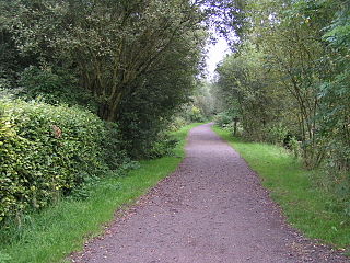
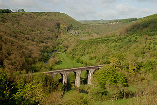
Cyclists on the Pennine Bridleway near Denshaw
Leaving Derbyshire for Greater Manchester, the trail follows the edge of a heather moor and picks up the trackbed of a former railway line along the Tame valley through the tourist village of Uppermill and to the village of Diggle. From here the trail heads west across moorland and descends to follow a dismantled railway towards Hollingworth Lake. It then crosses more moorland east of Littleborough before joining the Mary Towneley Loop near Summit.
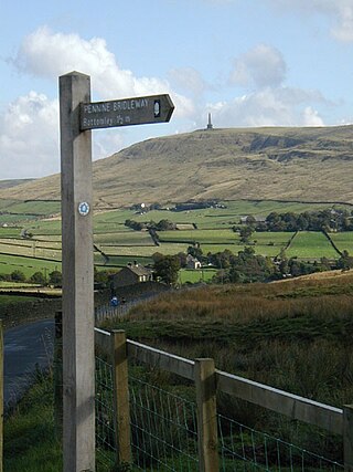
The shorter route follows the Mary Towneley Loop counterclockwise, heading north into West Yorkshire. The trail passes the villages of Bottomley and Mankinholes, then drops down to cross the Calder Valley just west of the town of Hebden Bridge. It then climbs to cross Heptonstall Moor and enters Lancashire south of Widdop.
The longer clockwise route of the Mary Towneley Loop heads west from Summit and climbs to Top of Leach at 474 metres (1,555ft). The trail passes through the town of Waterfoot in the Rossendale Valley and follows new tracks via Lumb before entering the Cliviger Gorge and then climbing up to the Long Causeway. It then heads north to the top of the Loop just east of Worsthorne.
Lancashire
From the top of the Mary Towneley Loop the trail heads north to the village of Wycoller, then turns west to pass south of Earby and Barnoldswick. For several miles it follows an old track named Coal Pit Lane to reach Gisburne Park on the River Ribble. It then heads north across the flatter landscape of the Ribble Valley to enter North Yorkshire just north of the village of Paythorne.
North Yorkshire and Cumbria
At the southern edge of the Yorkshire Dales the route reaches Long Preston on the busy A65 road. The route through Long Preston and across the A65 has not yet been finalised.[3] The trail heads north from Long Preston to the town of Settle. South of Settle the Settle Loop branches east to rejoin the main route just north of the town.
At Stainforth the route turns west to Feizor, Austwick and Clapham on ancient walled lanes. From Clapham the trail turns north east to Selside and crosses to the east side of Ribblesdale. It then joins the Pennine Way for 7 kilometres (4mi), climbing Cam Fell. A new trail is then followed west over high and exposed terrain to Newby Head. The route briefly enters Cumbria over Dent Fell, then reenters North Yorkshire at Garsdale Head.
At the head of Wensleydale the route follows an old track (Lady Anne's Way) to cross into the Mallerstang valley in Cumbria. The trail then crosses Wild Boar Fell to reach its present terminus near the village of Ravenstonedale.[2]
One feeder route has been opened, and two more are planned:
The 17-mile (27km) Calder–Aire Link starts at Bingley in West Yorkshire, and runs through Wilsden and across Oxenhope Moor to join the Mary Towneley Loop near Widdop.
The 42-mile (68km) West Pennine Link will run from Smithills Hall near Bolton to join the Mary Towneley Loop near Clowbridge Reservoir in Rossendale.
The West Pennine Perimeter is planned to join with the West Pennine Link to provide a circular route around the West Pennine Moors.[5]
Longdendale is a valley in the Peak District of England, north of Glossop and southwest of Holmfirth. The name means "long wooded valley" and the valley is mostly in the counties of Derbyshire and Greater Manchester.
The River Etherow is a river in northern England, and a tributary of the River Goyt. Although now passing through South Yorkshire, Derbyshire and Greater Manchester, it historically formed the ancient county boundary between Cheshire and Derbyshire. The upper valley is known as Longdendale. The river has a watershed of approximately 30 square miles (78 km2), and the area an annual rainfall of 52.5 inches (1,330 mm).
The Pennines, also known as the Pennine Chain or Pennine Hills, are a range of uplands mainly located in Northern England. Commonly described as the "backbone of England" because of its length and position, the range runs from the north Midlands to North East England, near the Anglo-Scottish border. The range starts near the valley of the River Trent to the south and extends northwards across the Peak District, South Pennines, Yorkshire Dales, and North Pennines, ending at the Tyne Gap. Beyond the gap are the Border Moors and Cheviot Hills, which are included in some definitions of the range.
The Pennine Way is a National Trail in England, with a small section in Scotland. The trail stretches for 268 miles (431 km) from Edale, in the northern Derbyshire Peak District, north through the Yorkshire Dales and Northumberland National Park and ends at Kirk Yetholm, just inside the Scottish border. The path runs along the Pennine hills, sometimes described as the "backbone of England". Although not the United Kingdom's longest National Trail, it is according to The Ramblers, "one of Britain's best known and toughest".
The mountains of Whernside, Ingleborough and Pen-y-ghent are collectively known as the Three Peaks. The peaks, which form part of the Pennine range, encircle the head of the valley of the River Ribble in the Yorkshire Dales National Park in the North of England.
The Dales Way is an 78.5-mile (126.3 km) long-distance footpath in Northern England, from Ilkley, West Yorkshire, to Bowness-on-Windermere, Cumbria. This walk was initially devised by the West Riding Ramblers' Association with the 'leading lights' being Colin Speakman and Tom Wilcock. The route was announced to the public in 1968 and the first recorded crossing was by a group of Bradford Grammar School Venture Scouts in 1969.
The High Peak Trail is a 17-mile (27 km) trail for walkers, cyclists and horse riders in the Peak District of England. Running from Dowlow (53.2059°N 1.8349°W), near Buxton, to High Peak Junction, Cromford (53.1004°N 1.5354°W), it follows the trackbed of the former Cromford and High Peak Railway, which was completed in 1831 to carry minerals and goods between the Cromford Canal wharf at High Peak Junction and the Peak Forest Canal at Whaley Bridge.
Woodhead is a small and scattered settlement at the head of the Longdendale valley in Derbyshire, England. It lies on the trans-Pennine A628 road connecting Greater Manchester and South Yorkshire, 6 miles (10 km) north of Glossop, 19 miles (31 km) east of Manchester and 18 miles (29 km) west of Barnsley. It is close to the River Etherow and the Trans Pennine Trail. Although part of Derbyshire since 1974, like nearby Tintwistle and Crowden, the hamlet was in the historic county of Cheshire.
The Midshires Way is a long-distance footpath and bridleway that runs for 230 miles (370 km) from the Chiltern Hills from near Bledlow in Buckinghamshire, through the Midlands counties of Northamptonshire, Leicestershire, Nottinghamshire and Derbyshire, to Stockport, Greater Manchester. It also links several other long-distance walking routes or trackways including The Ridgeway, the Pennine Bridleway and the Trans Pennine Trail.
The Pennine Cycleway is a Sustrans-sponsored route in the Pennines range in northern England, an area often called the "backbone of England". The route passes through the counties of Derbyshire, West Yorkshire, Lancashire, North Yorkshire, Cumbria and Northumberland. It is part of the National Cycle Network (NCN). Sustrans founder John Grimshaw calls it 'the best National Cycle Network route of the lot'.
The Sett Valley Trail is a 2.5-mile (4.0 km) cycle- and bridleway in Derbyshire, England, linking the village of Hayfield and the town of New Mills. It runs along the lower valley of the River Sett and follows the trackbed of a former branch railway line from New Mills Central to Hayfield, which opened in 1868 and closed in 1970. The line was purchased from British Rail by Derbyshire County Council in 1973. The station buildings at Hayfield were demolished in 1975; an information centre, picnic area, car park and toilets have now been built on the site. The Pennine Bridleway and Peak District Boundary Walk follow the section of the trail between Hayfield and Birch Vale.
The Mary Towneley Loop is a 47-mile (76 km) circular route that forms part of the Pennine Bridleway National Trail, along the borders of Lancashire and Yorkshire. The loop was opened in 2002, the first section of the Pennine Bridleway.
Parsley Hay railway station served Parsley Hay, a hamlet within Hartington Middle Quarter civil parish, about 9.3 miles (15 km) south east of Buxton, Derbyshire, on the LNWR line to Ashbourne. The nearest large settlement is the village of Hartington.
The Sabrina Way is a waymarked long-distance footpath and bridleway in England.
The Burnley Way is a 40-mile (64 km) long distance footpath in Lancashire, England. As a circular walk it can be walked from any point, but it is common to start and finish at the Weavers' Triangle Visitor Centre in Burnley. It covers a range of terrain from canal towpaths to open moorland.
A Dales High Way is a long-distance footpath in northern England. It is 90 miles (140 km) long and runs from Saltaire in West Yorkshire to Appleby-in-Westmorland, Cumbria, roughly parallel to the line of the Settle and Carlisle Railway.
The Yorkshire Water Way is a 104-mile (167 km) path that runs from Kettlewell in North Yorkshire to Langsett in South Yorkshire. It was devised by Mark Reid in conjunction with Yorkshire Water (YW) and it passes by over more than 20 reservoirs which are operated by Yorkshire Water.
The Peak District Boundary Walk is a circular 190-mile (310 km) walking trail, starting and finishing at Buxton and broadly following the boundary of the Peak District, Britain's first national park. The route was developed by the Friends of the Peak District and was launched on 17 June 2017.
The White Peak Loop is a 60-mile (97 km) route for walking, cycling and horse riding in the Peak District of England. The trail combines sections of the High Peak Trail and the Monsal Trail with linking sections through the towns of Buxton, Bakewell and Matlock. The White Peak Loop is being developed by Derbyshire County Council and as of 2022 some sections are not yet complete.
This page is based on this Wikipedia article Text is available under the CC BY-SA 4.0 license; additional terms may apply. Images, videos and audio are available under their respective licenses.