River Tame, Greater Manchester

Last updated

Tame
River Tame Reddish Vale.JPG
River Tame near Reddish Vale
River Tame map.png
The River Tame is highlighted in red
Coordinates: 53°24′51″N2°09′25″W / 53.4142°N 2.15689°W / 53.4142; -2.15689
Location
Country England
Region Greater Manchester
Physical characteristics
Source 
  locationwest of Buckstones Moss, West Yorkshire
  coordinates 53°37′07″N2°00′13″W / 53.6187°N 2.0035°W / 53.6187; -2.0035
  elevation473 m (1,552 ft)
Mouth River Mersey
  location
Stockport
  coordinates
53°24′51″N2°09′23″W / 53.4143°N 2.1565°W / 53.4143; -2.1565
  elevation
40 [1]  m (130 ft)
Length47.7 km (29.6 mi)
Basin size146 [2]  km2 (56 sq mi)
Basin features
River system River Mersey

The River Tame flows through Greater Manchester, England. It rises on Denshaw Moor and flows to Stockport where it joins the River Goyt to form the River Mersey.

Contents

Sources

The Tame rises on Denshaw Moor in Greater Manchester, close to the border with the modern metropolitan county of West Yorkshire but within the historic West Riding of Yorkshire.

Course

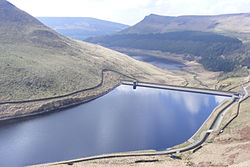
Most of the river's catchment lies on the western flank of the Pennines. The named river starts as compensation flow (that is, a guaranteed minimum discharge [3] ) from Readycon Dean Reservoir in the moors above Denshaw. The source is a little further north, just over the county border in West Yorkshire, close to the Pennine Way. The highest point of the catchment is Greater Manchester's highest point at Black Chew Head.

The river flows generally south through Delph, Uppermill, Mossley, Stalybridge, Ashton-under-Lyne, Dukinfield, Haughton Green, Denton and Hyde. The Division Bridge (which spans the river at Mossley), marks the meeting point of the traditional boundaries of Lancashire, Yorkshire and Cheshire. The section through Stalybridge was once mooted as a diversion route for the restoration of the Huddersfield Narrow Canal although the canal was later de-culverted along a different route. At the end of its course, the confluence with the River Goyt forms the River Mersey at Stockport.

The 19th-century industrial concentrations in the above-named urban areas resulted in the Tame being a much polluted waterway. As well as industrial pollution from the dyes and bleaches used in textile mills, effluent from specialised paper-making cigarette papers, engineering effluents, including base metal washings from battery manufacture, phenols from the huge coal-gas plant in Denton, rain-wash from roads and abandoned coal spoil heaps there was also the sewage effluent from the surrounding population. Up to two-thirds of the river's flow at its confluence with the Goyt had passed through a sewage works. The anti-pollution efforts of the last thirty years of the 20th century have resulted in the positive fauna distributions listed below.

The Centre for Ecology and Hydrology measures the flow at two points for the National River Flow Archive, at Portwood weir (Stockport) and at Broomstairs weir (Denton). Portwood weir is 1¼ miles above the confluence with the Mersey and contains the great majority of the final flow (with the exception of waste water from a concrete facility). [4]

Boundary line

The river has been a border from the earliest times between the Anglo-Saxon kingdoms of Northumbria and Mercia. [5] For its course after the Division Bridge in Mossley the river marks much of the historical boundary dividing Cheshire and Lancashire.

Mouth

Greenfield Reservoir Greenfield Reservoir.JPG
Greenfield Reservoir
Dovestone Reservoir Dovestones from Alphin Hill.jpg
Dovestone Reservoir
Railway viaduct and former lodge at Reddish Vale Reddish Vale viaduct.JPG
Railway viaduct and former lodge at Reddish Vale
The Tame (left) meets the Goyt in Stockport to form the Mersey Confluenceoftameandgoyt.JPG
The Tame (left) meets the Goyt in Stockport to form the Mersey

The Tame joins the River Goyt at Stockport, forming the River Mersey which eventually flows into the Irish Sea just past Liverpool.

Toponymy

The name Tame is attached to rivers across the UK in several forms, including Thames, Thame, Taff, and Tamar, alongside two other instances of Tame. [6] [7] The name is Celtic in origin, but the meaning is uncertain. [8] [9] Dark river or dark one has been suggested, [10] [11] but Ekwall [8] finds it unlikely; Mills suggests it may simply mean river (c.f. Avon, Humber, Tyne). [7] The names of the Mersey's co-tributaries Etherow and Goyt are equally ancient and mysterious. [8] Mersey is an Old English name (i.e. more recent) derived from "river at the boundary". The earlier name is lost: Dodgson suggests that Tame may have been the name for the whole of the Mersey. [9] The Metropolitan Borough of Tameside is named after the river. While it flows through the borough, the river neither rises nor finishes inside its boundaries; however, most of the built-up area alongside the river is in Tameside.

Fauna

The fish species present vary along the river's length. The lower reaches (near Reddish Vale Country Park) are home to coarse fish such as gudgeon (Gobio gobio), chub (Leuciscus cephalus), and roach (Rutilus rutilus); pike (Esox lucius) and perch (Perca fluviatilis) are also present. The upper reaches (above Ashton) support brown trout (Salmo trutta) and smaller numbers of some coarse fish. The populations are self-sustaining. Migratory fish such as Atlantic salmon and sea trout cannot navigate the river as the weir at Reddish Vale is too tall and has no fish pass. [12] Furthermore,

are all declared as salmonid waters by statute, and as such have set physical and chemical water quality objectives. [13] [14]

Hull Brook is a Site of Biological Importance (SBI). Hull Brook and Castleshaw Reservoir have populations of white-clawed crayfish. [15] The river is now clean enough in principle to support otters, but none were found in a survey in 2000–2002. [16]

Environment

In 2018 a study found that the river contained the greatest amount of microplastic contamination of any river yet surveyed. [17]

Tributaries

See also

Related Research Articles

Tameside Borough of Greater Manchester, England

The Metropolitan Borough of Tameside is a metropolitan borough of Greater Manchester in England. It is named after the River Tame, which flows through the borough, and includes the towns of Ashton-under-Lyne, Audenshaw, Denton, Droylsden, Dukinfield, Hyde, Mossley and Stalybridge. Its western border is approximately 4 miles (6.4 km) east of Manchester city centre. Tameside is bordered by the metropolitan boroughs of Stockport and Oldham to the south and north respectively, the city of Manchester to the west and the borough of High Peak in Derbyshire to the east across Longdendale. As of 2011 the overall population was 219,324.

River Etherow River in north west England

The River Etherow is a river in northern England, and a tributary of the River Goyt. Although now passing through South Yorkshire, Derbyshire and Greater Manchester, it historically formed the ancient county boundary between Cheshire and Derbyshire. The upper valley is known as Longdendale. The river has a watershed of approximately 30 square miles (78 km2), and the area an annual rainfall of 52.5 inches (1,330 mm).

River Mersey Major river emptying into Liverpool Bay

The River Mersey is a river in the North West of England. Its name is derived from Old English and means "boundary river", possibly referring to its having been a border between the ancient kingdoms of Mercia and Northumbria. For centuries it has formed part of the boundary between the historic counties of Lancashire and Cheshire.

Mottram in Longdendale Human settlement in England

Mottram in Longdendale is a village in Tameside, Greater Manchester, England. At the 2011 census, the population for the ward of Longdendale, which includes Mottram and the surrounding area, was 9,950.

River Goyt River in northwest England

The River Goyt is a tributary of the River Mersey in North West England.

Denton, Greater Manchester Town in Greater Manchester, England

Denton is a town in Tameside, Greater Manchester, England, five miles (8 km) east of Manchester city centre. Historically part of Lancashire, it had a population of 36,591 at the 2011 Census.

Stockport Town in Greater Manchester, England

Stockport is a large town in Greater Manchester, England, 7 miles (11 km) south-east of Manchester city centre, where the rivers Goyt and Tame merge to create the River Mersey. It is the largest town in the metropolitan borough of the same name.

Reddish Area of Greater Manchester, England

Reddish is an area in Metropolitan Borough of Stockport, Greater Manchester, England. 4.6 miles (7.4 km) south-east of Manchester city centre. At the 2011 Census, the population was 28,052. Historically part of Lancashire, Reddish grew rapidly in the Industrial Revolution and still retains landmarks from that period, such as Houldsworth Mill, a former textile mill.

Hyde, Greater Manchester Town in Tameside, Greater Manchester, England

Hyde is a town in Tameside, Greater Manchester, England, which had a population of 34,003 in 2011.

Mossley Human settlement in England

Mossley (/ˈmɒzli/) is a town and civil parish in Tameside, Greater Manchester, England, in the upper Tame Valley and the foothills of the Pennines, 3 miles (4.8 km) southeast of Oldham and 8.9 miles (14.3 km) east of Manchester.

Metropolitan Borough of Stockport Borough of Greater Manchester, England

The Metropolitan Borough of Stockport is a metropolitan borough of Greater Manchester in North West England, south-east of central Manchester. As well as the towns of Stockport, Bredbury and Marple, it includes the outlying areas of Hazel Grove, Bramhall, Cheadle, Cheadle Hulme Gatley, Reddish, Woodley and Romiley. In 2001, it had a population of 284,500.

Reddish Vale

Reddish Vale is in the Tame Valley close to Reddish, Greater Manchester, England. The centre of the vale is around the bottom of Reddish Vale Road. Reddish Vale Country Park is a country park managed by Stockport Metropolitan Borough Council. It covers 161 hectares in all and comprises some of the traditional Reddish Vale area, Reddish Vale Farm and the grazing land and Woodhall Fields, about half a mile to the south. Part of it is a designated local nature reserve.

County Borough of Stockport Former municipal borough in present-day town of Stockport

Stockport County Borough was created by the Municipal Corporations Act 1835 when the existing Borough of Stockport was reformed as a municipal borough. Until 1835 the town was governed by a charter dating from circa 1220 granted by Ranulph de Blondeville, 4th Earl of Chester. The municipal borough consisted of parts of Cheshire, namely the township of Stockport and the neighbouring areas of Edgeley and Portwood and part of Heaton Norris in Lancashire.

There is evidence of activity around Reddish – a settlement in Greater Manchester, England – before the Norman conquest in the presence of Nico Ditch and some Saxon coins. The recorded history of Reddish begins at the turn of the 13th century when it was documented as "Redich". Reddish remained a predominantly rural settlement throughout the medieval period, but expanded to become a mixed industrial and residential area during the 19th century. It developed rapidly during the Industrial Revolution, and still retains landmarks from that period, such as Houldsworth Mill.

Stockport Castle was a promontory castle in Stockport, Cheshire. The castle was in the medieval town, overlooking a ford over the River Mersey. It was first documented in 1173, but the next mention of it is in 1535 when it was in ruins. What remained of the castle was demolished in 1775.

Palmer Mills, Stockport were cotton spinning mills in Portwood, Stockport, Greater Manchester. Built in the late 19th century, It was taken over by the Lancashire Cotton Corporation in the 1930s and sold on. Renamed the Stockport Paper Mill they survived into the 21st century when they were demolished to be replaced by modern businesses.

Vernon Mill, Stockport Cotton mill in Greater Manchester, England

Vernon Mill, Stockport is a former cotton spinning mill in Portwood, Stockport, Greater Manchester, England. Built in 1881, it was taken over by the Lancashire Cotton Corporation in 1930 and later sold on. Although still in business use, it is now a grade II listed building.

Kingston Mill, Stockport Cotton spinning mill in Greater Manchester, England

Kingston Mill, Stockport is a mid nineteenth century cotton spinning mill in Edgeley, Stockport, Greater Manchester, England. It was taken over by the Lancashire Cotton Corporation in the 1930s and passed to Courtaulds in 1964. Production finished, it was made over to multiple uses.

References

Notes

  1. Boyce, D (August 2005). "Mersey and Bollin Catchment abstraction management strategy" (PDF). Environment Agency North West, Warrington. p. 5. Retrieved 13 March 2007.
  2. Boyce, D (March 2004). "The Tame, Goyt and Etherow catchment abstraction management strategy" (PDF). Environment Agency, Warrington. p. 6. Retrieved 13 March 2007.
  3. "Glossary". Centre for Ecology and Hydrology. Archived from the original on 10 December 2007. Retrieved 8 January 2008.
  4. "69027 - Tame at Portwood". The National River Flow Archive. Centre for Ecology and Hydrology. Archived from the original on 27 October 2007. Retrieved 8 January 2008.
  5. Oliver, G.J (2008). "Tameside-Mottram history". Tameside Family Histories. Retrieved 28 October 2011.
  6. Ekwall, Bror Oscar Eilert (1922). The Place-Names of Lancashire. Publications of the University of Manchester, English series, number 11. Manchester: Manchester University Press.
  7. 1 2 Mills, A D (1998). A dictionary of English place-names. Oxford: Oxford University Press. ISBN   0-19-280074-4.
  8. 1 2 3 Ekwall, Eilert (1928). English river names. Oxford: Clarendon Press.
  9. 1 2 Dodgson, J McN (1966). The place-names of Cheshire, part 1. Cambridge University Press.
  10. Ekwall, Bror Oscar Eilert (1947). The Concise Oxford Dictionary of English Place Names. Oxford: Clarendon Press.
  11. Potter, Simeon M A (1955). Cheshire Place-Names (Reprinted from the Transactions of the Historic Society of Lancashire and Cheshire). London: International University Booksellers.
  12. "River Tame fish survey". Environment Agency. 8 December 2004. Archived from the original on 25 February 2006. Retrieved 7 January 2008.
  13. "Freshwater Fish Directive". DEFRA. 13 January 2004. Archived from the original on 21 November 2008. Retrieved 8 January 2008.
  14. "Schedule 2 Freshwaters in England and Wales to which Classification SW applies" (PDF). DEFRA. July 1998. Archived from the original (PDF) on 26 June 2007. Retrieved 8 January 2008.
  15. "Report on update of sites of biological importance". Oldham MBC. 15 October 2007. Archived from the original (Word document) on 14 October 2011. Retrieved 20 January 2008.
  16. "Fourth Otter Survey of England 2000–2002" (PDF). Environment Agency. 2002. Archived from the original (PDF) on 21 December 2007. Retrieved 4 February 2008.
  17. Hurley, Rachel; Woodward, Jamie; Rothwell, James J. (April 2018). "Microplastic contamination of river beds significantly reduced by catchment-wide flooding". Nature Geoscience. 11 (4): 251–257. Bibcode:2018NatGe..11..251H. doi:10.1038/s41561-018-0080-1.

Bibliography

  • Carter, Charles Frederick, ed. (1962). Manchester and its region : a survey prepared for the meeting of the British Association for the Advancement of Science held in Manchester August 29 to September 5, 1962. Manchester: Manchester University Press.
  • Arrowsmith, Peter (1997). Stockport : a history. Stockport: Stockport Metropolitan Borough Council. ISBN   0-905164-99-7.
  • Holden, Roger N. (1998). Stott & Sons : architects of the Lancashire cotton mill. Lancaster: Carnegie. ISBN   1-85936-047-5.
  • Williams, Mike; D A Farnie (1992). Cotton mills in Greater Manchester. Preston: Carnegie. ISBN   0-948789-69-7.
  • Greater Manchester Council (1981). Tame Valley : report of survey and issues. Greater Manchester Council.

Route map:

KML file (edithelp)
    KML is from Wikidata