The River Bollin and its tributaries within its catchment area. The direction of flow is east to west. Also shown is the sub-catchment area of the River Dean.
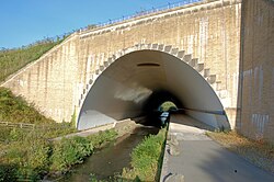
To the west of Styal, the Bollin flows to the south of Manchester Airport. Between 1997 and 2000, the airport underwent expansion work and the runways were extended. To accommodate the longer runways, the River Bollin was diverted via a culvert underneath the southern runway.[7]
For its final 10 miles (16km) it defines the southwestern portion of the border between Greater Manchester and Cheshire. To the south of Hale, the Bollin valley is crossed by the Mid-Cheshire railway line.[8] Below Bowdon, the River Birkin, Mobberley Brook and streams coming from Rostherne Mere and Tatton Meres enter the Bollin. After Bowdon, the river flows through the village of Little Bollington; a similarly named town of Bollington lies further upstream near Macclesfield, but this town lies on the River Dean before its junction with the Bollin.[4]
The town of Macclesfield used to dispose all its waste and sewage into the Bollin. The profusion of human sewage in the Bollin was still common in 1850.[citation needed] Efforts to clean up the Mersey and its tributaries led to the return of the Atlantic salmon to the Mersey, Bollin and Goyt. In 2025, salmon parr were found in the Bollin for the first time since 2015.[10]
Tributaries
Agden Brook (L)
Millington Clough
Birkin Brook (L)
Blackburn's Brook (L)
Shawgreen Brook (L)
Rostherne Brook
Mopperley Brook (R)
Mobberley Brook
Swim Brook (R)
Whim Brook (R)
Whitehall Brook (R)
Pott Brook (R)
Sugar Brook (R)
Tatton Mere brook (L)
Pedley Brook (R)
Marthall Brook
Bollin Valley Way
The Bollin Valley Way is a 25-mile (40km)footpath which follows the route of the River Bollin from Macclesfield Riverside Park to the Manchester Ship Canal at Partington.[11]
References
Wikimedia Commons has media related to River Bollin.
This page is based on this Wikipedia article Text is available under the CC BY-SA 4.0 license; additional terms may apply. Images, videos and audio are available under their respective licenses.