Bramhall

Last updated

Bramhall
Bramall Hall SE view, 2005.jpg
Bramall Hall is a Tudor mansion and local landmark.
Greater Manchester UK location map 2.svg
Red pog.svg
Bramhall
Location within Greater Manchester
Area15.93 km2 (6.15 sq mi)
Population17,436 (2011)
  Density 1,095/km2 (2,840/sq mi)
OS grid reference SJ890845
Metropolitan borough
Metropolitan county
Region
Country England
Sovereign state United Kingdom
Post town STOCKPORT
Postcode district SK7
Dialling code 0161
Police Greater Manchester
Fire Greater Manchester
Ambulance North West
UK Parliament
List of places
UK
England
Greater Manchester
53°21′25″N2°09′50″W / 53.357°N 2.164°W / 53.357; -2.164

Bramhall is an area in the Metropolitan Borough of Stockport, Greater Manchester, England. [1] [2] [3] Historically in Cheshire, it had a population of 17,436 at the 2011 Census. [4] [5] [6]

Contents

History

In 1066 the Anglo-Saxon manor of Bramall was held as separate estates by two freemen, Brun and Hakon. [7] [8] In 1070, William the Conqueror subdued the north-west of England, and divided the land among his followers. The manor was given to Hamon de Massey, who eventually became the first Baron of Dunham Massey. [9] The earliest reference to Bramall was recorded in the Domesday Book as "Bramale", a name derived from the Old English words brom meaning broom, both indigenous to the area, and halh meaning nook or secret place, probably by water. De Massey received the manor as wasteland, since it had been devastated in the Harrying of the North . By the time of the Domesday survey, the land was recovering and cultivated again. [10]

In 1875, Bramhall was one of eight civil parishes of Cheshire to be included in the Stockport Rural rural sanitary district. The sanitary district became the Stockport Rural District in 1894. The parish was abolished in 1900 and its former area became part of the Hazel Grove and Bramhall civil parish and urban district. In 1974, the district was abolished, under the Local Government Act 1972, and transferred to Greater Manchester to be combined with that of other districts to form the Metropolitan Borough of Stockport. [11]

Governance

Bramhall is part of the parliamentary constituency of Cheadle, represented by Conservative Mary Robinson since 2015.

Landmarks

Bramhall War Memorial Bramhall War Memorial.JPG
Bramhall War Memorial

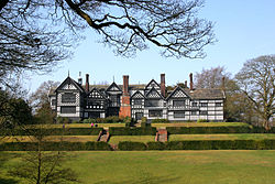
Bramall Hall, set in 26 hectares (64 acres) of parkland, is an example of a 14th-century Cheshire building. In 2016 an extensive programme of restoration work was completed. The Ladybrook flows westward through the park, joining the River Mersey at Cheadle.

Bramhall War Memorial is in Mayfield Place. It was unveiled by Sir Henry de Beauvoir De Lisle on 18 December 1921. [12] It commemorates the 90 men of Bramhall who fell in the two world wars. [13] [14]

Churches

St Michael and All Angels' Church St Michael's Church, Bramhall.jpg
St Michael and All Angels' Church

The Church of England parish church of St Michael and All Angels [15] in Robins Lane was consecrated in 1911 when Bramhall Parish was created, although the building was not completed until 1963. It replaced an earlier mission church opened in 1890. [16]

Other churches in Bramhall include the Methodist Church near the centre of the village, the United Reformed Church located on Bramhall Lane South, the Baptist Church located on Woodford Road, the Catholic Church of St. Vincent de Paul on Handley Road and Ford's Lane Evangelical Church.

Recreation

Bramhall has a cricket club and there are three lawn tennis clubs (LTC): Bramhall Queensgate LTC, to the north; Bramhall Lane LTC, close to the village; and Bramhall Park LTC, close to the park. There are also two golf clubs in Bramhall, each with 18-hole courses: Bramhall Golf Club and Bramall Park Golf Club. Stockport RUFC in Bramhall has been host to Headlander Festival. There is a recreation centre linked with Bramhall High School with indoor and outdoor facilities.

Transport

Bramhall railway station is on a spur of the West Coast Main Line between Manchester Piccadilly and London Euston, via Macclesfield and Stoke-on-Trent. Local trains stop every hour Monday-Saturday on their way to/from Manchester Piccadilly and Stoke-on-Trent; there is a much reduced service on Sundays. [17]

Bus services link Bramhall with Manchester (42B), Stockport (378/9), Cheadle Hulme (42B,307/8), Woodford (42B), Parrs Wood (42B) and Hazel Grove (307/8). Routes are predominantly operated by Stagecoach Manchester. [18]

Housing

Alongside numerous listed buildings, [19] the sixties and early seventies saw a growth in Bramhall's housing stock. New developments included the Parkside and New House Farm areas in the north of Bramhall and the Dairyground estate which features a co-operative, apartments and a care home. The Dairyground estate is served by Stagecoach Manchester [20] and is in close proximity to Bramhall railway station. Bramhall High School is situated in the Dairyground estate, which is part of the Bramhall North Ward. [21]

Little Australia

The area of Little Australia (so called as all the roads are named after towns in Australia) is bordered by the West Coast Main Line to the north, the Bramhall oil terminal to the east, Bramhall village centre to the west and Moorend Golf Club to the south. The longest road in Little Australia is Meadway, which starts in Bramhall shopping centre and runs through the heart of the estate for its entire length. Meadway has a number of shops, care homes and two large car parking facilities which are served by multiple CCTV cameras. There is also a recycling centre situated on the Meadway East car park. Lumb Lane park is located on the estate and consists of two football pitches, a small children's playground and a hard surface football/basketball court. Bramhall Village Hall is located on Lumb Lane. Queensgate Primary School is located on Albany Road. Little Australia is part of the Bramhall South Ward.

New House Farm

The New House Farm area is to the north of Bramhall and extends into Hazel Grove after crossing the Fred Perry Way. It is home to a McColl's newsagent and a pub, the Shady Oak. The main roads through New House Farm are Grange Road, which links to Bramhall Lane South, and Ringmore Road. New House Farm is served by the 374 bus route between Hazel Grove Station and Reddish. The New House Farm area contains a section of the Fred Perry Way joining the estate from Bridge Lane and exiting up into Woodsmoor. This area is part of the Bramhall North Ward.

Education

Bramhall has five primary schools: Ladybrook, Moss Hey, Nevill Road, Pownall Green and Queensgate. Bramhall High School is the local secondary school.

Notable people

Notable local residents have included:

See also

Related Research Articles

<span class="mw-page-title-main">Stockport</span> Town in Greater Manchester, England

Stockport is an industrial town in Greater Manchester, England, 7 miles (11 km) south-east of Manchester, 9 miles (14 km) south-west of Ashton-under-Lyne and 12 miles (19 km) north of Macclesfield. The River Goyt and Tame merge to create the River Mersey here. It is the main settlement of the wider Metropolitan Borough of Stockport.

<span class="mw-page-title-main">Davenport, Greater Manchester</span> Human settlement in England

Davenport is a district of Stockport, Greater Manchester, England; until 1974, it was part of Cheshire. At the 2011 census, it had a population of 14,924.

<span class="mw-page-title-main">Cheadle Hulme</span> Suburb of Stockport, Greater Manchester, England

Cheadle Hulme is a suburb in the Metropolitan Borough of Stockport, Greater Manchester, England,. Historically in Cheshire, it is 2 miles (3.2 km) south-west of Stockport and 8 miles (12.9 km) south-east of Manchester. It lies in the Ladybrook Valley, on the Cheshire Plain, and the drift consists mostly of boulder clay, sands and gravels. In 2011, it had a population of 26,479.

<span class="mw-page-title-main">Cheadle (UK Parliament constituency)</span> UK Parliament constituency since 1950

Cheadle is a borough constituency represented in the House of Commons of the Parliament of the United Kingdom.

<span class="mw-page-title-main">Hazel Grove</span> Village in England

Hazel Grove is a village in the Metropolitan Borough of Stockport, Greater Manchester, England. Historically in Cheshire, it had a population of 14,022 at the 2021 Census.

<span class="mw-page-title-main">Cheadle, Greater Manchester</span> Village in Greater Manchester, England

Cheadle is a village in the Metropolitan Borough of Stockport, Greater Manchester, England. Within the boundaries of the historic county of Cheshire, it borders Cheadle Hulme, Gatley, Heald Green and Cheadle Heath in Stockport, and East Didsbury in Manchester. In 2011, it had a population of 14,698.

<span class="mw-page-title-main">Hazel Grove (UK Parliament constituency)</span> Parliamentary constituency in the United Kingdom, 1974 onwards

Hazel Grove is a constituency in Greater Manchester represented in the House of Commons of the UK Parliament since 2015 by William Wragg, a Conservative.

<span class="mw-page-title-main">Offerton, Greater Manchester</span> Human settlement in England

Offerton is a suburb of Stockport, Greater Manchester, England. Historically in Cheshire, it includes Bosden Farm, Foggbrook and the Offerton Estate. Offerton School closed in 2012 and is now home to Castle Hill High School. The ward population at the UK Census 2011 was 13,720.

<span class="mw-page-title-main">Bramall Hall</span> Tudor manor house in Greater Manchester

Bramall Hall is a largely Tudor manor house in Bramhall, Greater Manchester, England. The building is timber-framed and its oldest parts date from the 14th century, with additions from the 16th and 19th centuries. The house functions as a museum and its 70 acres (28 ha) of landscaped parkland are open to the public.

<span class="mw-page-title-main">Woodford, Greater Manchester</span> Suburb of Stockport, Greater Manchester, England

Woodford is a suburban village in the Metropolitan Borough of Stockport, Greater Manchester, England, 5.2 miles (8.4 km) south of Stockport, 5.7 miles (9.2 km) north-west of Macclesfield and 10.7 miles (17.2 km) south-east of Manchester. Woodford is the most southerly point of Greater Manchester; it consists of a ribbon of properties and a housing development along the A5102 road, around which is open countryside.

Bosden Farm is a suburban housing estate with a population of around 3,000 on the edge of Offerton, bordering Marple and Hazel Grove, in Stockport, England, surrounded by land used for agricultural purposes.Bosden Farm also boasts its own football team with both male and female teams competing across Manchester Set up in 2022 by local sports entrepreneur Thom Mck.

<span class="mw-page-title-main">Metropolitan Borough of Stockport</span> Borough of Greater Manchester, England

The Metropolitan Borough of Stockport is a metropolitan borough of Greater Manchester in England. It is south-east of central Manchester and south of Tameside. As well as the towns of Stockport, Bredbury and Marple, it includes the outlying villages and suburbs of Hazel Grove, Bramhall, Cheadle, Cheadle Hulme, Gatley, Reddish, Woodley and Romiley. In 2021, it had a population of 295,243, making it the fourth-most populous borough of Greater Manchester.

<span class="mw-page-title-main">Knutsford (UK Parliament constituency)</span> Parliamentary constituency in the United Kingdom, 1885–1983

Knutsford was a county constituency in Cheshire which returned one Member of Parliament (MP) to the House of Commons of the Parliament of the United Kingdom from 1885 until it was abolished for the 1983 general election.

<span class="mw-page-title-main">Handforth</span> Human settlement in England

Handforth is a town and civil parish in Cheshire, England, 9 miles (14 km) south of Manchester city centre. The population at the 2011 census was 6,266. In the 1960s and 1970s, two overspill housing estates, Spath Lane in Handforth, and Colshaw Farm nearby in Wilmslow, were built to re-house people from inner city Manchester. It lies between Wilmslow, Heald Green, Stanley Green and Styal and forms part of the Greater Manchester Built-up Area.

<span class="mw-page-title-main">Ladybrook Valley</span>

The Ladybrook Valley begins in the English Peak District and runs through Stockport. In its 15 kilometres (9.3 mi) course the brook falls 275 metres (902 ft). At various points it is called Bollinhurst Brook, Norbury Brook, Bramhall Brook, the Ladybrook and the Mickerbrook.

<span class="mw-page-title-main">Micker Brook</span> River in North West England

Micker Brook is a tributary of the River Mersey in North West England.

<span class="mw-page-title-main">Stockport bus station</span> Bus station in Stockport, Greater Manchester, England

Stockport bus station in Stockport, Greater Manchester was a bus terminus for approximately sixty-five bus services. It opened on 2 March 1981 on the site of a former car park. Before the bus station opened, most services terminated at Mersey Square.

Hazel Grove and Bramhall are towns in the Metropolitan Borough of Stockport, Greater Manchester, England. The towns, together with the village of Woodford, contain 29 listed buildings that are recorded in the National Heritage List for England. Of these, one is listed at Grade I, the highest of the three grades, one is at Grade II*, the middle grade, and the others are at Grade II, the lowest grade. Most of the listed buildings are houses and associated structures, farmhouses and farm buildings. The other listed buildings include churches and lych gates, and two war memorials.

The ceremonial county of Cheshire, which comprises the unitary authorities of Cheshire East, Cheshire West and Chester, Halton and Warrington, has returned 11 MPs to the UK Parliament since 1997.

References

  1. Williams, Jennifer (3 December 2008). "Happy to be home in Bramhall". Stockport Express. M.E.N. Media.
  2. 1 2 "Bramhall named friendliest spot". Manchester Evening News. 19 April 2010. Retrieved 11 March 2014.
  3. Stockport council (2005),"Bramhall Area Public Health Report".
  4. "United Kingdom: North West England". City Population. Retrieved 8 January 2016.
  5. Bramhall South and Bramhall North Wards "Ward mid-year population estimates for England and Wales (experimental)". Office for National Statistics. Mid-2007 Quinary Estimates for 2009 wards (experimental).
  6. "History and facts". I Love Bramhall. Retrieved 29 January 2020.
  7. "Bramhall Hall, Cheshire". bramhill.net. Archived from the original on 26 January 2015.
  8. "Bramhall". opendomesday.org. Open Domesday.
  9. "Bramhall Park (2005)". Stockport Metropolitan Borough Council. Archived from the original on 11 March 2014.
  10. Dean, E. Barbara (1977). Bramall Hall: The Story of an Elizabethan Manor House. Stockport: Recreation & Culture Division, Metropolitan Borough Council of Stockport. p. 14. ISBN   0-905164-06-7.
  11. "Districts". Eyewitness in Manchester. Archived from the original on 24 August 2007.
  12. "Bramhall War Memorial". Alderley & Wilmslow Advertiser. 23 December 1921. p. 2.
  13. "The Men of the Bramhall War Memorial" (PDF). Archived from the original (PDF) on 13 November 2013. Retrieved 13 November 2013.
  14. "Bramhall". www.iwm.org.uk. Imperial War Museums, War Memorials Register.
  15. "St Michael & All Angels Parish Church".
  16. "Bramhall, St Michael and All Angels". The National Archives. Retrieved 13 November 2013.
  17. "Timetables and engineering information for travel with Northern". Northern Trains . May 2023. Retrieved 3 July 2023.
  18. "Stops in Bramhall". Bus Times. 2023. Retrieved 3 July 2023.
  19. "Listed Buildings in Bramhall South and Woodford Ward, Stockport". britishlistedbuildings.co.uk. Retrieved 29 January 2020.
  20. "National Rail Enquiries – Bus Maps for Bramhall". Archived from the original on 31 March 2009. Retrieved 11 February 2010.
  21. Skinner, Miles (29 November 2006). "Bramhall businesses forced to barricade themselves in". Stockport Express. M.E.N. Media.
  22. McCabe, Bob (2005). Ronnie Barker: the authorized biography. London: BBC Books. pp. 30–31. ISBN   9780563522461.
  23. "Inside the late British football star George Best's house". House and Garden. 10 July 2018. Retrieved 29 January 2020.
  24. "Dame Wendy Hiller | British actress". Encyclopedia Britannica. Retrieved 29 January 2020.
  25. "At Home with Paul Ince". Independent. 30 September 1995. Retrieved 29 January 2020.
  26. Viner, Brian (23 October 2011). "'Cancer did not change me. I still have the same hunger for my profession". Independent. Retrieved 29 January 2020.
  27. "Schmeichel and Bruce are back in action". Mirror. 31 July 2010. Retrieved 29 January 2020.
  28. Spackman, Anne (29 September 1995). "The 11 footballers on the right are hot property. But do they live in one?". Independent. Retrieved 29 January 2020.