The Brittoniclanguages form one of the two branches of the Insular Celtic language family; the other is Goidelic. It comprises the extant languages Breton, Cornish, and Welsh. The name Brythonic was derived by Welsh Celticist John Rhys from the Welsh word Brython, meaning Ancient Britons as opposed to an Anglo-Saxon or Gael.

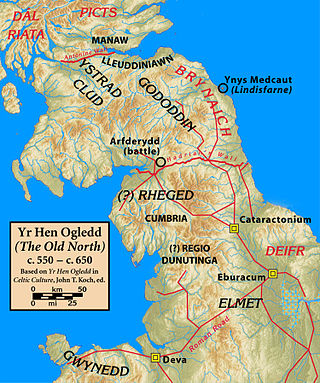
Rheged was one of the kingdoms of the Hen Ogledd, the Brittonic-speaking region of what is now Northern England and southern Scotland, during the post-Roman era and Early Middle Ages. It is recorded in several poetic and bardic sources, although its borders are not described in any of them. A recent archaeological discovery suggests that its stronghold was located in what is now Galloway in Scotland rather than, as was previously speculated, being in Cumbria. Rheged possibly extended into Lancashire and other parts of northern England. In some sources, Rheged is intimately associated with the king Urien Rheged and his family. Its inhabitants spoke Cumbric, a Brittonic dialect closely related to Old Welsh.

A glen is a valley, typically one that is long and bounded by gently sloped concave sides, unlike a ravine, which is deep and bounded by steep slopes. The word is Goidelic in origin: gleann in Irish and Scottish Gaelic, glion in Manx. The designation "glen" also occurs often in place names. Glens are appreciated by tourists for their tranquility and scenery.
Pictish is an extinct Brittonic Celtic language spoken by the Picts, the people of eastern and northern Scotland from Late Antiquity to the Early Middle Ages. Virtually no direct attestations of Pictish remain, short of a limited number of geographical and personal names found on monuments and early medieval records in the area controlled by the kingdoms of the Picts. Such evidence, however, shows the language to be an Insular Celtic language related to the Brittonic language then spoken in most of the rest of Britain.
Cumbric was a variety of the Common Brittonic language spoken during the Early Middle Ages in the Hen Ogledd or "Old North" in what is now the counties of Westmorland, Cumberland, northern Lancashire in Northern England and the southern Scottish Lowlands. It was closely related to Old Welsh and the other Brittonic languages. Place name evidence suggests Cumbric may also have been spoken as far south as Pendle and the Yorkshire Dales. The prevailing view is that it became extinct in the 12th century, after the incorporation of the semi-independent Kingdom of Strathclyde into the Kingdom of Scotland.

Elmet, sometimes Elmed or Elmete, was an independent Brittonic Celtic Cumbric speaking kingdom between about the 4th century and mid 7th century.

The River Irwell is a tributary of the River Mersey in north-west England. It rises at Irwell Springs on Deerplay Moor, approximately 1+1⁄2 miles north of Bacup and flows southwards for 39 mi (63 km) to meet the Mersey near Irlam. The Irwell marks the boundary between Manchester and Salford, and its lower reaches have been canalised and now form part of the Manchester Ship Canal.

The River Irk is a river in the historic county of Lancashire in the North West England that flows through the northern most Lancastrian towns of the ceremonial county of Greater Manchester.
In much of the "Old World" the names of many places cannot easily be interpreted or understood; they do not convey any apparent meaning in the modern language of the area. This is due to a general set of processes through which place names evolve over time, until their obvious meaning is lost. In contrast, in the "New World", many place names' origins are known.

Y Gododdin is a medieval Welsh poem consisting of a series of elegies to the men of the Brittonic kingdom of Gododdin and its allies who, according to the conventional interpretation, died fighting the Angles of Deira and Bernicia at a place named Catraeth in about AD 600. It is traditionally ascribed to the bard Aneirin and survives only in one manuscript, the "Book of Aneirin".

The Britons, also known as Celtic Britons or Ancient Britons, were an indigenous Celtic people who inhabited Great Britain from at least the British Iron Age until the High Middle Ages, at which point they diverged into the Welsh, Cornish, and Bretons. They spoke Common Brittonic, the ancestor of the modern Brittonic languages.

Yr Hen Ogledd, or in English the Old North, is the historical region that was inhabited by the Brittonic people of sub-Roman Britain in the Early Middle Ages, now Northern England and the southern Scottish Lowlands, alongside the Celtic Kingdom of Elmet. Its population spoke a variety of the Brittonic language known as Cumbric which is closely related to, if not a dialect of Old Welsh. The people of Wales and the Hen Ogledd considered themselves to be one people, and both were referred to as Cymry ('fellow-countrymen') from the Brittonic word combrogi. The Hen Ogledd was distinct from the parts of Great Britain inhabited by the Picts, Anglo-Saxons, and Scoti.

The River Spodden is a watercourse in North West England, one of two major tributaries of the River Roch. It rises in the Lancashire South Pennine hills north of Whitworth and flows south through what is now known as the Whitworth Valley to Rochdale, Greater Manchester, where the river merges with the River Roch. Nestled within the picturesque wooded valley is Healey Dell Nature Reserve.

The Beal is a small river in Greater Manchester, England, and is a tributary of the River Roch. It rises in the Beal Valley in green space between Sholver and Royton, before continuing northwards through Shaw and Crompton, Newhey, Milnrow and Belfield.

Cumbrian toponymy refers to the study of place names in Cumbria, a county in North West England, and as a result of the spread of the ancient Cumbric language, further parts of northern England and the Southern Uplands of Scotland.

The River Lostock is a river in Lancashire, England.
Aber and Inver are common elements in place-names of Celtic origin. Both mean "confluence of waters" or "river mouth". Their distribution reflects the geographical influence of the Brittonic and Goidelic language groups, respectively.

Elvanfoot is a small village in South Lanarkshire, Scotland.

The House of Rheged or the House of Rhun was an informal royal dynasty who ruled in the brittonic Kingdom of Rheged. The line is traced back to Coel Hen whose descendants are often referred to as the Coeling. The dynasty includes Urien, King of Rheged and his son Sir Ywain a Knight of the Round Table in Arthurian legend.


