
Rochdale is a large town in Greater Manchester, England, at the foothills of the South Pennines in the dale on the River Roch, 5.3 miles (8.5 km) northwest of Oldham and 9.8 miles (15.8 km) northeast of Manchester. It is the administrative centre of the Metropolitan Borough of Rochdale, which had a population of 211,699 in 2011.

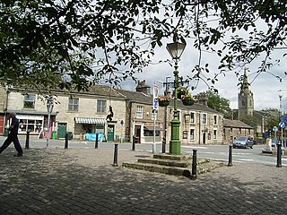
Milnrow is a suburban town within the Metropolitan Borough of Rochdale, in Greater Manchester, England. It lies on the River Beal at the foothills of the South Pennines, and forms a continuous urban area with Rochdale. It is 1.9 miles (3.1 km) east of Rochdale town centre, 10.4 miles (16.7 km) north-northeast of Manchester, and spans urban, suburban and rural locations—from Windy Hill in the east to the Rochdale Canal in the west. Milnrow is adjacent to junction 21 of the M62 motorway, and includes the village of Newhey, and hamlets at Tunshill and Ogden.

The River Roch is a river in Greater Manchester in North West England, a tributary of the River Irwell, that gives Rochdale its name.
Littleborough is a town within the Metropolitan Borough of Rochdale, in Greater Manchester, England. It is located in the upper Roch Valley by the foothills of the South Pennines, 3 miles (4.8 km) northeast of Rochdale and 12.6 miles (20.3 km) north-northeast of Manchester; Milnrow and the M62 motorway are to the south, and the rural uplands of Blackstone Edge are to the east. In 2001, Littleborough and its suburbs of Calderbrook, Shore and Smithy Bridge, had a population of 13,807.

Rochdale is a seat represented in the House of Commons of the UK Parliament. It has elected one Member of Parliament (MP) since its 1832 creation.
The Oldham Loop Line was a local railway route in Greater Manchester, England, used by trains that ran from Manchester Victoria to Rochdale via Oldham Mumps. Services on the line at the time of its closure were operated by Northern Rail.

Newhey is a suburban village in the Milnrow area of the Metropolitan Borough of Rochdale, in Greater Manchester, England. It lies at the foot of the South Pennines, by Junction 21 of the M62 motorway and on the River Beal, 2.7 miles (4.3 km) east-southeast of Rochdale, 10.3 miles (16.6 km) northeast of Manchester.

Shaw and Crompton is a tram stop on the Oldham and Rochdale Line (ORL) of Greater Manchester's light-rail Metrolink system. It opened to passengers on 16 December 2012 and is located in Shaw and Crompton, a part of the Metropolitan Borough of Oldham, England.

The Beal is a small river in Greater Manchester, England, and is a tributary of the River Roch. It rises in the Beal Valley in green space between Sholver and Royton, before continuing northwards through Shaw and Crompton, Newhey, Milnrow and Belfield.

Crompton Moor is an area of moorland in the South Pennines, in North West England. It lies along the northeastern outskirts of Shaw and Crompton, in the Metropolitan Borough of Oldham, Greater Manchester.

Butterworth was a township occupying the southeastern part of the parish of Rochdale, in the hundred of Salford, Lancashire, England. It encompassed 12.1 square miles (31 km2) of land in the South Pennines which spanned the settlements of Belfield, Bleaked-gate-cum-Roughbank, Butterworth Hall, Clegg, Haughs, Hollingworth, Kitcliffe, Lowhouse, Milnrow, Newhey, Ogden, Rakewood, Smithy Bridge, Tunshill and Wildhouse. It extended to the borders of Crompton to the south, and to the highest points of Bleakedgate Moor and Clegg Moor, up to the ridge of Blackstone Edge, to the east, where its boundary was the old county boundary between Lancashire and Yorkshire.

Butterworth Hall Brook is a water course in Greater Manchester, North-West England, which flows through the village of Milnrow and is a tributary of the River Beal.

Piethorne Brook is a watercourse in Greater Manchester. It is a tributary of the River Beal.

Kingsway Business Park is a tram stop on the Oldham and Rochdale Line (ORL) of Greater Manchester's Metrolink network. It is located in Firgrove, on the northeastern side of Kingsway Business Park in the Metropolitan Borough of Rochdale, between the Milnrow and Newbold stations. It opened as part of Phase 3a of the system's expansion, on 28 February 2013.

Belfield is a locality within Rochdale, in Greater Manchester, England. It lies at the confluence of the River Beal and River Roch, 1.3 miles (2.1 km) east-northeast of Rochdale's town centre. Belfield is bound to the east by the Rochdale Canal, which forms Rochdale's common boundary with Firgrove in Milnrow.
Moss Brook is a watercourse in Rochdale, Greater Manchester and a tributary of the River Roch. It originates in Newbold, and flows Northwards to join the River Roch. The majority of the brook is now culverted.
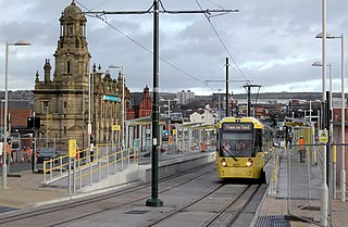
The Oldham and Rochdale Line (ORL) is a tram line of the Manchester Metrolink in Greater Manchester running from Manchester city centre to Rochdale town centre via Oldham, using most of the trackbed of the former Oldham Loop Line which closed in 2009. The line was re-opened in a modified form as a tram line between 2012 and 2014, as part of phase three of the system's expansion.
