Romiley

Last updated

Romiley
Stockport Road, Romiley.jpg
Stockport Road in Romiley
Greater Manchester UK location map 2.svg
Red pog.svg
Romiley
Location within Greater Manchester
OS grid reference SJ945905
Metropolitan borough
Metropolitan county
Region
Country England
Sovereign state United Kingdom
Post town STOCKPORT
Postcode district SK6
Dialling code 0161
Police Greater Manchester
Fire Greater Manchester
Ambulance North West
UK Parliament
List of places
UK
England
Greater Manchester
53°24′41″N2°05′03″W / 53.41128°N 2.08421°W / 53.41128; -2.08421

Romiley is a village in the Metropolitan Borough of Stockport, Greater Manchester, England. Historically part of Cheshire, it borders Marple, Bredbury and Woodley. At the 2011 census, the Romiley ward, which includes Compstall, Bredbury Green and a large part of Bredbury, had a population of 14,139. [1]

Contents

History

Compstall Road in Romiley, 1905 Compstall Road, Romiley 1905 (2).jpg
Compstall Road in Romiley, 1905

Romiley (or Rvmelie in Medieval Latin) is documented in the Domesday Book as being predominantly agricultural, with 16 ploughlands (areas defined as 120 acres each) and 92 leagues of woodland. [2] It had no recorded population.

Romiley's agricultural nature continued during the centuries leading up to the late Victorian era, when it became a residential area with a small district centre.

The Peak Forest Canal flows around the west and south of Romiley. It was completed in 1805. Although much of the canal fell into disuse by the early 1960s, it was restored and subsequently reopened in April 1974. [3]

Education

There are four primary schools: Romiley Primary School, Bredbury Green Primary School, St. Christopher's Catholic Primary School and Greave Primary School (which is on the border with Woodley).

Secondary education is provided by Werneth School and Harrytown Catholic High School in Bredbury, with much of the suburb being in the catchment area for Marple Hall School in nearby Marple.

Amenities

Romiley Arms Romiley Arms - opposite the station.jpg
Romiley Arms

Romiley has its own theatre, the Forum Theatre. This is a building owned by Stockport Council but, since 2003, has been managed by NK Theatre Arts, a registered charity which provides all-inclusive performing arts workshops for children, young people and adults. The theatre is also used by many other local community groups in Stockport. [4]

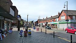
There are many pubs in Romiley, including The Friendship Inn, Romiley Arms, Platform One, Duke of York and Stock Dove.

Geography

Romiley's surroundings are rural, although it is a suburb, with fields to the north, south and east. Compstall, between Romiley and Marple, is home to the Etherow Country Park which is the largest country park in Stockport.

Transport

Romiley station, from Beech Lane Romiley Station.jpg
Romiley station, from Beech Lane

The suburb is served by Romiley railway station, which is on the Hope Valley Line between Sheffield and Manchester Piccadilly. Services run westbound to Manchester Piccadilly, either via Bredbury or Woodley; eastbound trains travel either to Rose Hill Marple or to Marple and beyond to New Mills Central and Sheffield. [5]

Romiley is served by several bus services, which are operated by Stagecoach Manchester. The most regular services run on a Stockport circular route to Bredbury and Portwood (383 anticlockwise) and to Marple and Offerton (384 clockwise). There is also an hourly 382 service, which runs from Stockport to/from Woodley, via Romiley. [6]

Conservation areas

Romiley contains four conservation areas, a designation made by the local council to protect locations which have special architectural or historical character. It helps reduce traffic, preserve wildlife and important landscapes, and restricts making changes which affect the look of the area such as changing front doors, roofing, facades or windows. They are:

A further conservation area adjoins Romiley at Hatherlow in Bredbury.

Notable people

See also

Related Research Articles

<span class="mw-page-title-main">Stockport</span> Town in Greater Manchester, England

Stockport is a town in Greater Manchester, England, 8 miles (13 km) south-east of Manchester, 9 miles (14 km) south-west of Ashton-under-Lyne and 12 miles (19 km) north of Macclesfield. The Rivers Goyt and Tame merge to create the River Mersey here. It is the main settlement of the wider Metropolitan Borough of Stockport.

<span class="mw-page-title-main">Hyde, Greater Manchester</span> Town in Tameside, Greater Manchester, England

Hyde is a town in Tameside, Greater Manchester, England, which had a population of 35,890 in 2021. Within the boundaries of the historic county of Cheshire, it is located 5 miles (8 km) north-east of Stockport, 6 miles (10 km) west of Glossop and 8 miles (13 km) east of Manchester.

<span class="mw-page-title-main">Compstall</span> Village in Greater Manchester, England

Compstall is a village in the Metropolitan Borough of Stockport, Greater Manchester, England; it is situated between Marple Bridge and Romiley and is historically part of Cheshire. It was formerly a mill village, built by George Andrew in the 1820s to house his 800 workers. Most of the original mill cottages and other structures remain unchanged.

<span class="mw-page-title-main">Marple, Greater Manchester</span> Town in Greater Manchester, England

Marple is a town in the Metropolitan Borough of Stockport, Greater Manchester, England. It is on the River Goyt, 9 miles (14 km) south-east of Manchester, 9 miles (14 km) north of Macclesfield and 4 miles (6 km) south-east of Stockport. In 2011, it had a population of 23,686.

<span class="mw-page-title-main">Woodley, Greater Manchester</span> Human settlement in England

Woodley is a suburb in the Metropolitan Borough of Stockport, Greater Manchester, England. It is situated on the east side of the Peak Forest Canal, next to Bredbury, Romiley and the boundary with Tameside, at Gee Cross.

<span class="mw-page-title-main">High Lane, Greater Manchester</span> Human settlement in England

High Lane is a village in the Metropolitan Borough of Stockport, Greater Manchester, England, on the Macclesfield Canal, 5 miles (8 km) from Stockport.

<span class="mw-page-title-main">Heaton Mersey</span> Suburb of Stockport, Greater Manchester, England

Heaton Mersey is a suburb of Stockport, Greater Manchester, England. It is situated on the north-western border of Stockport, adjacent to Didsbury and Burnage which are in the City of Manchester.

<span class="mw-page-title-main">Bredbury</span> Town in Greater Manchester, England

Bredbury is a town in the Metropolitan Borough of Stockport, Greater Manchester, England. It is located 8 miles (12.9 km) south-east of Manchester, 2 miles (3.2 km) east of Stockport and 3 miles (4.8 km) south-west of Hyde. At the 2011 census, it had a population of 16,721.

<span class="mw-page-title-main">Metropolitan Borough of Stockport</span> Borough of Greater Manchester, England

The Metropolitan Borough of Stockport is a metropolitan borough of Greater Manchester in England. It is south-east of central Manchester and south of Tameside. As well as the towns of Stockport, Bredbury and Marple, it includes the outlying villages and suburbs of Hazel Grove, Bramhall, Cheadle, Cheadle Hulme, Gatley, Reddish, Woodley and Romiley. In 2022, it had a population of 297,107, making it the fourth-most populous borough of Greater Manchester.

<span class="mw-page-title-main">Marple Bridge</span> District in Greater Manchester, England

Marple Bridge is a district of Marple in the Metropolitan Borough of Stockport, Greater Manchester, England. The River Goyt runs through the centre of the village. Marple Bridge shares borders with Mellor, Marple, Compstall, New Mills, Strines, Mill Brow and Chisworth. It is in the ecclesiastical parish of Mellor; the parish church of St. Thomas stands several hundred feet higher than the village, overlooking Greater Manchester and Cheshire.

<span class="mw-page-title-main">Romiley railway station</span> Railway station in Greater Manchester, England

Romiley railway station serves Romiley, in the Metropolitan Borough of Stockport, Greater Manchester, England. It is sited at a junction of two parts of the Hope Valley Line, providing services between Manchester Piccadilly, New Mills Central and Sheffield, and also between Piccadilly and Rose Hill Marple.

<span class="mw-page-title-main">Rose Hill Marple railway station</span> Railway station in Stockport, England

Rose Hill Marple is one of two railway stations that serve Marple in the Metropolitan Borough of Stockport, England; the other is Marple railway station. The station, which opened in 1869, is the last surviving stop on the former Macclesfield, Bollington and Marple Railway (MB&MR). It is connected via a short branch to the Hope Valley Line. The original line to Macclesfield was closed in January 1970, leaving Rose Hill Marple as the terminus of the route; the Middlewood Way, a shared-use path, now follows the preserved route of the disused MB&MR.

<span class="mw-page-title-main">Woodley railway station</span> Railway station in Greater Manchester, England

Woodley railway station serves the suburb of Woodley in Stockport, Greater Manchester, England. The station is 9+14 miles (14.9 km) east of Manchester Piccadilly on a branch of the Hope Valley Line to Rose Hill Marple. It is situated where the A560 road from Stockport to Gee Cross, near Hyde, crosses over the railway line.

<span class="mw-page-title-main">Cheshire Ring</span> Canal ring in North West England

The Cheshire Ring is a canal cruising circuit or canal ring, which includes sections of six canals in and around Cheshire and Greater Manchester in North West England: the Ashton Canal, Peak Forest Canal, Macclesfield Canal, Trent and Mersey Canal, Bridgewater Canal and Rochdale Canal.

<span class="mw-page-title-main">Wood Mill, Woodley</span> Mill located by the River Tame in Stockport, Cheshire

Wood Mill was a mill located by the River Tame in Stockport, Cheshire. Originally built in the early to mid 19th century and used as a bone mill. After 1848 the building was converted to a woollen mill and was rebuilt in 1864. In the 1930s, the building was used for colour and chemical manufacturing and demolished in 1964. The remains of the building are located on the bend of Lambeth Grove, Woodley between Wellington Works and Riverside Kennels.

<span class="mw-page-title-main">Stockport bus station</span> Former bus station in Stockport, Greater Manchester, England

Stockport bus station in Stockport, Greater Manchester, England, was a bus terminus for approximately 65 bus services. It opened on 2 March 1981 on the site of a former car park. Before the bus station opened, most services terminated at Mersey Square.

<span class="mw-page-title-main">Bredbury and Woodley (Stockport electoral ward)</span> Human settlement in England

Bredbury and Woodley is an electoral ward in the Metropolitan Borough of Stockport. It elects three Councillors to Stockport Metropolitan Borough Council using the first past the post electoral method, electing one Councillor every year without election on the fourth.

<span class="mw-page-title-main">Bredbury Green and Romiley (Stockport electoral ward)</span> Human settlement in England

Bredbury Green & Romiley is an electoral ward in the Metropolitan Borough of Stockport.

Bredbury and Romiley are towns in the Metropolitan Borough of Stockport, Greater Manchester, England. The towns, together with the area of Woodley and the village of Compstall and the surrounding countryside, contain 43 listed buildings that are recorded in the National Heritage List for England. Of these, two are listed at Grade II*, the middle grade, and the others are at Grade II, the lowest grade.

References

  1. "Census 2011".
  2. https://opendomesday.org/place/SJ9390/romiley/ [ bare URL ]
  3. Edwards, Lewis A. (1985). Inland Waterways of Great Britain (6th ed.). Imray, Laurie, Norie & Wilson. ISBN   0-85288-081-2.
  4. "Home - Forum Theatre".
  5. "Timetables and engineering information for travel with Northern". Northern Railway. May 2023. Retrieved 21 May 2023.
  6. "Romiley Bus Services". Bus Times. 2023. Retrieved 21 May 2023.