The canal network of the United Kingdom played a vital role in the Industrial Revolution. The UK was the first country to develop a nationwide canal network which, at its peak, expanded to nearly 4,000 miles in length. The canals allowed raw materials to be transported to a place of manufacture, and finished goods to be transported to consumers, more quickly and cheaply than by a land based route. The canal network was extensive and included feats of civil engineering such as the Anderton Boat Lift, the Manchester Ship Canal, the Worsley Navigable Levels and the Pontcysyllte Aqueduct.

The Bridgewater Canal connects Runcorn, Manchester and Leigh, in North West England. It was commissioned by Francis Egerton, 3rd Duke of Bridgewater, to transport coal from his mines in Worsley to Manchester. It was opened in 1761 from Worsley to Manchester, and later extended from Manchester to Runcorn, and then from Worsley to Leigh.

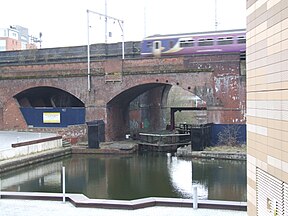
Castlefield is an inner-city conservation area in Manchester, North West England. The conservation area which bears its name is bounded by the River Irwell, Quay Street, Deansgate and Chester Road. It was the site of the Roman era fort of Mamucium or Mancunium which gave its name to Manchester. It was the terminus of the Bridgewater Canal, the world's first industrial canal, built in 1764; the oldest canal warehouse opened in 1779. The world's first passenger railway terminated here in 1830, at Liverpool Road railway station and the first railway warehouse opened here in 1831.

The Sankey Canal in North West England, initially known as the Sankey Brook Navigation and later the St Helens Canal, is a former industrial canal, which when opened in 1757 was England's first of the Industrial revolution, and the first modern canal.
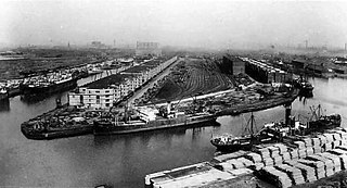
Manchester docks were nine docks in Salford, Stretford and Manchester, at the eastern end of the Manchester Ship Canal in North West England, which formed part of the Port of Manchester from 1894 until their closure in 1982. They marked the upper reaches of the ship canal, and were a destination for both coastal and ocean-bound vessels carrying cargo and passengers, often travelling to and from Canada.

The River Irwell is a tributary of the River Mersey in north west England. It rises at Irwell Springs on Deerplay Moor, approximately 1+1⁄2 miles north of Bacup and flows southwards for 39 mi (63 km) to meet the Mersey near Irlam. The Irwell marks the boundary between Manchester and Salford, and its lower reaches have been canalised and now form part of the Manchester Ship Canal.

The canals of the United Kingdom are a major part of the network of inland waterways in the United Kingdom. They have a varied history, from use for irrigation and transport, through becoming the focus of the Industrial Revolution, to today's role of recreational boating. Despite a period of abandonment, today the canal system in the United Kingdom is again increasing in use, with abandoned and derelict canals being reopened, and the construction of some new routes. Canals in England and Wales are maintained by navigation authorities. The biggest navigation authorities are the Canal & River Trust and the Environment Agency, but other canals are managed by companies, local authorities or charitable trusts.
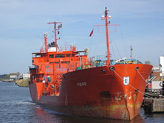
Runcorn Docks, originally the Bridgewater Docks, is an inland port on the Manchester Ship Canal in the town of Runcorn, Cheshire, England. It is operated by Peel Ports and handles bulk and project cargo.

The Rochdale Canal is in Northern England, between Manchester and Sowerby Bridge, part of the connected system of the canals of Great Britain. Its name refers to the town of Rochdale through which it passes.

A large number of canals were built in Cheshire, England, during the early phases of the Industrial Revolution to transport goods and raw materials. This resulted in a significant canal network which is now enjoyed by holiday-makers, anglers, walkers, and others.

The Manchester and Salford Junction Canal was a canal in the city of Manchester. It was originally built to provide a direct waterway between the Mersey and Irwell Navigation and the Rochdale Canal. The canal opened in 1839 and was abandoned in 1922.

The Cheshire Ring is a canal cruising circuit or canal ring, which includes sections of six canals in and around Cheshire and Greater Manchester in North West England: the Ashton Canal, Peak Forest Canal, Macclesfield Canal, Trent and Mersey Canal, Bridgewater Canal and Rochdale Canal.

The North Pennine Ring is a canal ring which crosses the Pennines between Manchester, Leeds and Castleford. It follows parts of five canals, and shares much of its route with the Outer Pennine Ring, which uses a different route for the southern crossing of the Pennines.

The Outer Pennine Ring is an English canal ring which crosses the Pennines between Manchester, Leeds and Castleford. Its route follows parts of eight canals, and includes the longest canal tunnel in England. The ring was completed in 2001, with the opening of the Huddersfield Narrow Canal. Much of the route is shared with the North Pennine Ring, which crosses the Pennines by a different route on the southern leg.

The Runcorn and Weston Canal was a short canal near Runcorn in Cheshire, England, constructed to link the Weston Canal, which is part of the River Weaver Navigation, to the Bridgewater Canal and Runcorn Docks. It was completed in 1859, but was little used. Around half of it became the Arnold Dock in 1876, when it was made wider and deeper, and linked to Fenton Dock by a ship lock. The dock section and some of the remaining canal were filled in during the 1960s, and the remainder is in a derelict state.

The Mersey and Irwell Navigation was a river navigation in North West England, which provided a navigable route from the Mersey estuary to Salford and Manchester, by improving the course of the River Irwell and the River Mersey. Eight locks were constructed between 1724 and 1734, and the rivers were improved by the construction of new cuts several times subsequently. Use of the navigation declined from the 1870s, and it was ultimately superseded by the Manchester Ship Canal, the construction of which destroyed most of the Irwell section of the navigation and the long cut between Latchford and Runcorn.

The Runcorn to Latchford Canal was a man-made canal that ran from Runcorn, to the Latchford area of Warrington. It connected the Mersey and Irwell Navigation to the River Mersey at Runcorn.
Daresbury was a Mersey flat that is now in a ruinous condition. It lies, partly submerged, in Sutton Lock on River Weaver in Cheshire, England. The lock and its contents are designated as a Scheduled Ancient Monument.