Navigable aqueduct

Last updated
Narrowboat crossing the World Heritage Pontcysyllte Aqueduct in Wales Pontcysyllte aqueduct arp.jpg
Narrowboat crossing the World Heritage Pontcysyllte Aqueduct in Wales

Navigable aqueducts (sometimes called navigable water bridges) are bridge structures that carry navigable waterway canals over other rivers, valleys, railways or roads. They are primarily distinguished by their size, carrying a larger cross-section of water than most water-supply aqueducts. Roman aqueducts were used to transport water and were created in Ancient Rome. The 662-metre (2,172 ft) long steel Briare aqueduct carrying the Canal latéral à la Loire over the River Loire was built in 1896. It was ranked as the longest navigable aqueduct in the world for more than a century, until the Magdeburg Water Bridge in Germany took the title in the early 21st century.

Contents

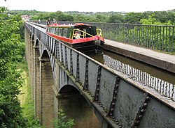
Early aqueducts such as the three on the Canal du Midi had stone or brick arches, the longest span being 18.3 metres (60 ft) on the Cesse Aqueduct, built in 1690. But, the weight of the construction to support the trough with the clay or other lining to make it waterproof made these structures clumsy. In 1796 Longdon-on-Tern Aqueduct, the first large cast iron aqueduct was built by Thomas Telford at Longdon-on-Tern on the Shrewsbury Canal. It has a total length of 57 metres (187 ft) across three intermediate piers. Within ten years Telford had completed the far more ambitious Pontcysyllte Aqueduct in Wales on the Llangollen Canal over the River Dee valley, with a total length 307 metres and a height of 38 metres, making it the tallest navigable aqueduct in the world. Other cast-iron aqueducts followed, such as the single-span Stanley Ferry Aqueduct on the Calder and Hebble Navigation in 1839, with its innovative 50-metre (160 ft) through arch design.

There were 32 navigable aqueducts on the Erie Canal, constructed 1817–1825 in New York State, United States.

Notable navigable aqueducts

Out-of-use cast-iron Longdon-on-Tern Aqueduct Longden-on-Tern1.jpg
Out-of-use cast-iron Longdon-on-Tern Aqueduct
The Magdeburg Water Bridge seen from the shores of the Elbe Trogbrucke Magdeburg.jpg
The Magdeburg Water Bridge seen from the shores of the Elbe

See also

Related Research Articles

<span class="mw-page-title-main">Thomas Telford</span> Scottish civil engineer (1757–1834)

Thomas Telford was a Scottish civil engineer. After establishing himself as an engineer of road and canal projects in Shropshire, he designed numerous infrastructure projects in his native Scotland, as well as harbours and tunnels. Such was his reputation as a prolific designer of highways and related bridges, he was dubbed the Colossus of Roads, and, reflecting his command of all types of civil engineering in the early 19th century, he was elected as the first president of the Institution of Civil Engineers, a post he held for 14 years until his death.

<span class="mw-page-title-main">River Avon, Bristol</span> River in the south west of England

The River Avon is a river in the southwest of England. To distinguish it from a number of other rivers of the same name, it is often called the Bristol Avon. The name 'Avon' is a cognate of the Welsh word afon, meaning 'river'.

<span class="mw-page-title-main">Stratford-upon-Avon Canal</span>

The Stratford-upon-Avon Canal is a canal in the south Midlands of England. The canal, which was built between 1793 and 1816, runs for 25.5 miles (41.0 km) in total, and consists of two sections. The dividing line is at Kingswood Junction, which gives access to the Grand Union Canal. Following acquisition by a railway company in 1856, it gradually declined, the southern section being un-navigable by 1945, and the northern section little better.

<span class="mw-page-title-main">Llangollen Canal</span> Canal in Wales and Shropshire, UK

The Llangollen Canal is a navigable canal crossing the border between England and Wales. The waterway links Llangollen in Denbighshire, north Wales, with Hurleston in south Cheshire, via the town of Ellesmere, Shropshire. The name, which was coined in the 1980s, is a modern designation for parts of the historic Ellesmere Canal and the Llangollen navigable feeder, both of which became part of the Shropshire Union Canals in 1846.

<span class="mw-page-title-main">Pontcysyllte Aqueduct</span> Waterway in Wales

The Pontcysyllte Aqueduct is a navigable aqueduct that carries the Llangollen Canal across the River Dee in the Vale of Llangollen in northeast Wales.

<span class="mw-page-title-main">William Jessop</span> British civil engineer (1745-1814)

William Jessop was an English civil engineer, best known for his work on canals, harbours and early railways in the late 18th and early 19th centuries.

<span class="mw-page-title-main">Canals of the United Kingdom</span> Network of inland waterways

The canals of the United Kingdom are a major part of the network of inland waterways in the United Kingdom. They have a varied history, from use for irrigation and transport, through becoming the focus of the Industrial Revolution, to today's role of recreational boating. Despite a period of abandonment, today the canal system in the United Kingdom is again increasing in use, with abandoned and derelict canals being reopened, and the construction of some new routes. Canals in England and Wales are maintained by navigation authorities. The biggest navigation authorities are the Canal & River Trust and the Environment Agency, but other canals are managed by companies, local authorities or charitable trusts.

<span class="mw-page-title-main">Chirk Aqueduct</span> Bridge in Chirk

Chirk Aqueduct is a 70-foot (21 m) high and 710-foot (220 m) long navigable aqueduct that carries what is now the Llangollen Canal across the Ceiriog Valley near Chirk, on the England-Wales border, spanning the two countries.

<span class="mw-page-title-main">River Tern</span> River in Shropshire, England

The River Tern is a river in Shropshire, England. It rises north-east of Market Drayton in the north of the county. The source of the Tern is considered to be the lake in the grounds of Maer Hall, Staffordshire. From here it flows for about 30 miles (48 km), being fed by the River Meese and the River Roden, until it joins the River Severn near Attingham Park, Atcham.

<span class="mw-page-title-main">Shrewsbury Canal</span> English Canal

The Shrewsbury Canal was a canal in Shropshire, England. Authorised in 1793, the main line from Trench to Shrewsbury was fully open by 1797, but it remained isolated from the rest of the canal network until 1835, when the Birmingham and Liverpool Junction Canal built the Newport Branch from Norbury Junction to a new junction with the Shrewsbury Canal at Wappenshall. After ownership passed to a series of railway companies, the canal was officially abandoned in 1944; many sections have disappeared, though some bridges and other structures can still be found. There is an active campaign to preserve the remnants of the canal and to restore the Norbury to Shrewsbury line to navigation.

<span class="mw-page-title-main">Longdon-on-Tern</span> Human settlement in England

Longdon-Upon-Tern is a village in east central Shropshire, England. It is in the unitary district of Telford and Wrekin, and is approximately 11 kilometres (6.8 mi) east of Shrewsbury and 11 kilometres (6.8 mi) north-west of Telford. Longdon-Upon-Tern is situated on the River Tern, a tributary of the River Severn.

<span class="mw-page-title-main">Cosgrove aqueduct</span> Bridge in Cosgrove

Cosgrove aqueduct is a navigable cast iron trough navigable aqueduct that carries the Grand Union Canal over the River Great Ouse, on the borders between Buckinghamshire and Northamptonshire at the northwest margin of Milton Keynes in England. The present structure was built in 1811, to replace a previous brick structure that had failed. When the present structure was erected, it was known as the "Iron Trunk". The structure has two cast iron trough spans, with a single central masonry pier. The abutments were constructed in masonry but have been refaced in brick during the twentieth century. The trough is 15 feet (4.6 m) wide, 6 ft 6 in (1.98 m) deep, with a total length of 101 feet (31 m). The canal surface is about 40 feet (12 m) above the surface of the river. There are large approach earthworks about 36 feet (11 m) high above the valley floor and 150 feet (46 m) wide, with a total length of half a mile (800m).

<span class="mw-page-title-main">Briare aqueduct</span> Aqueduct in central France

The Briare Aqueduct in central France carries the Canal latéral à la Loire over the river Loire on its journey to the Seine. It replaced a river-level crossing from the canal to meet the Briare Canal that was hazardous in times of flood. Between 1896 and 2003 it was the longest navigable aqueduct in the world, until the opening of the Magdeburg Water Bridge.

<span class="mw-page-title-main">Canal latéral à la Loire</span> Canal in central France

The Canal latéral à la Loire was constructed between 1827 and 1838 to connect the Canal de Briare at Briare and the Canal du Centre at Digoin, a distance of 196 kilometres (122 mi). It replaced the use of the river Loire, which was unreliable during winter floods and summer droughts. Aqueducts were used to cross the Allier at Le Guétin and the Loire at Digoin. However, because of the extreme length required, an aqueduct was not built to cross the Loire at Briare until 1896, when the Briare aqueduct was constructed.

<span class="mw-page-title-main">Berwick Tunnel</span>

Berwick Tunnel is a canal tunnel located on the Shrewsbury Canal, Shropshire, England, UK.

<span class="mw-page-title-main">Almond Aqueduct</span> Bridge in West Lothian/City of Edinburgh

The Almond Aqueduct, also known as the Lin's Mill Aqueduct, is a navigable aqueduct that carries the Union Canal over the River Almond in Scotland, west of Ratho, Edinburgh.

<span class="mw-page-title-main">Slateford Aqueduct</span> Bridge in Slateford

The Slateford Aqueduct is a navigable aqueduct that carries the Union Canal over the Water of Leith at Slateford, Edinburgh, Scotland. Completed in 1822, it has eight arches and spans a length of 500 feet (150 m).

<span class="mw-page-title-main">Avon Aqueduct</span> Bridge in Linlithgow

The Avon Aqueduct is a navigable aqueduct that carries the Union Canal over the River Avon, near Linlithgow, Scotland.

William Reynolds was an ironmaster and a partner in the ironworks in Coalbrookdale in Shropshire, England. He was interested in advances in science and industry, and invented the inclined plane for canals.

<span class="mw-page-title-main">Longdon-on-Tern Aqueduct</span> Grade I listed navigable aqueduct near Longdon-on-Tern, Shropshire, England

The Longdon-on-Tern Aqueduct, near Longdon-on-Tern in Shropshire, was one of the first two canal aqueducts to be built from cast iron.

References

  1. "Meet One of the World's Most Unique Waterways: The Veluwemeer Aqueduct". 3 April 2021.