Houtribdijk

Last updated
Houtribdijk luchtfoto richting Lelystad.jpg
Houtribdijk
Official nameHoutribdijk
LocationN302 EnkhuizenLelystad
Separating MarkermeerIJsselmeer
Total length26 km
Width68 m
Construction started1963
Construction ended1976
Houtribdijk, satellite image Houtribdijk Netherlands Satellite Photo by Sentinel-2 30 June 2018.jpg
Houtribdijk, satellite image

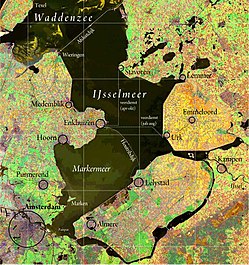
The Houtribdijk is a dam in the Netherlands, built between 1963 and 1976 as part of the Zuiderzee Works, which connects the cities of Lelystad and Enkhuizen. On the west side of the dike is the Markermeer and on the east is the IJsselmeer. The 26-kilometer-long dike was intended for the Markerwaard, but the construction of this polder was abandoned in 2003 due to environmental concerns. The Houtribdijk was widened and reinforced between 2017 and 2020. [1] [2]

Although called a dike (withholding water from land area), the Houtribdijk is actually a dam (separating water bodies). [1]

Parts of the dike are known as the Markerwaarddijk [3] and the Lelydijk. [4] It is also called the "Enkhuizen–Lelystad dike" (dijk Enkhuizen-Lelystad) in traffic announcements, as if it had no official name. [5] The dike also used to be called Enkhuizerzanddijk. [3]

The road that runs on the dike is the N302 [5] and is used by 8,500 vehicles per day with a speed limit of 100 km/h. The road also features a biking path alongside the N302 on the northeastern side. Marine traffic can cross the dike at either the locks or the naviduct at Enkhuizen. Alternatively, there is a lock system at Lelystad.[ citation needed ]

About halfway along the dike there is Trintelhaven  [ nl ], [3] an emergency harbor. Trintelhaven is also the site of a restaurant and an AM broadcasting station, which used to operate on 1395 kHz with 20 kW. It uses as antenna a 54-meters-tall free-standing grounded-lattice steel mast, which was built in 1999. The mast carries a wire antenna, which runs up the tower and is fixed to a horizontal cross on the top of the tower.[ citation needed ]

The Houtribdijk separates the Markermeer from the IJsselmeer. The dike in the north is the Afsluitdijk. IJsselmeer satellite.jpg
The Houtribdijk separates the Markermeer from the IJsselmeer. The dike in the north is the Afsluitdijk.
The Houtribdijk near Lelystad. Houtribdijk vanuit de lucht.jpg
The Houtribdijk near Lelystad.

Related Research Articles

<span class="mw-page-title-main">Nieuwe Waterweg</span> Ship canal in the Netherlands

The Nieuwe Waterweg is a ship canal in the Netherlands from het Scheur west of the town of Maassluis to the North Sea at Hook of Holland: the Maasmond, where the Nieuwe Waterweg connects to the Maasgeul. It is the artificial mouth of the river Rhine.

<span class="mw-page-title-main">Lelystad</span> City and municipality in Flevoland, Netherlands

Lelystad is a Dutch municipality and the capital city of the province of Flevoland in the central Netherlands. The city, built on reclaimed land, was founded in 1967 and was named after Cornelis Lely, who engineered the Afsluitdijk that made the reclamation possible. Lelystad is situated approximately three metres below sea level.

<span class="mw-page-title-main">IJsselmeer</span> Lake in the Netherlands

The IJsselmeer, also known as Lake IJssel in English, is a closed-off inland bay in the central Netherlands bordering the provinces of Flevoland, North Holland and Friesland. It covers an area of 1,100 km2 (420 sq mi) with an average depth of 4.5 m (15 ft). The river IJssel, which the lake was named after, flows into the IJsselmeer.

<span class="mw-page-title-main">Zuiderzee</span> Former inland sea in the Netherlands, now the IJsselmeer

The Zuiderzee or Zuider Zee, historically called Lake Almere and Lake Flevo, was a shallow bay of the North Sea in the northwest of the Netherlands. It extended about 100 km inland and at most 50 km wide, with an overall depth of about 4 to 5 metres (13–16 feet) and a coastline of about 300 km. It covered 5,000 km2 (1,900 sq mi). Its name is Dutch for "southern sea", indicating that the name originates in Friesland, to the north of the Zuiderzee.

<span class="mw-page-title-main">Zuiderzee Works</span> Land reclamation in the Netherlands

The Zuiderzee Works is a system of dams and dikes, land reclamation and water drainage work, which was the largest hydraulic engineering project undertaken by the Netherlands during the twentieth century. The project involved the damming of the Zuiderzee, a large, shallow inlet of the North Sea, and the reclamation of land in the newly enclosed water using polders. Its main purposes are to improve flood protection and create additional land for agriculture.

<span class="mw-page-title-main">Enkhuizen</span> Municipality in North Holland, Netherlands

Enkhuizen is a municipality and a city in the Netherlands, in the province of North Holland and the region of West-Frisia.

<span class="mw-page-title-main">Afsluitdijk</span> Dam

The Afsluitdijk is a major dam and causeway in the Netherlands. It was constructed between 1927 and 1932 and runs from Den Oever in North Holland province to the village of Zurich in Friesland province, over a length of 32 kilometres (20 mi) and a width of 90 metres (300 ft), at an initial height above Amsterdam Ordnance Datum of between 6.7 metres (22 ft) along the section at Friesland, and 7.4 metres (24 ft) where it crosses the deep channel of the Vlieter. The height at the greater sea depths west of Friesland was required to be a minimum of 7 metres everywhere when originally constructed.

<span class="mw-page-title-main">Markerwaard</span>

The Markerwaard is the name of a proposed, but never built, polder adjoining the IJsselmeer in the central Netherlands. Its construction would have resulted in the near-total reclamation of the Markermeer.

<span class="mw-page-title-main">Zuiderzee Museum</span> Museum in Enkhuizen, Netherlands

The Zuiderzee Museum, located on Wierdijk in the historic center of Enkhuizen, is a Dutch museum devoted to preserving the cultural heritage and maritime history from the old Zuiderzee region. With the closing of the Afsluitdijk on May 28, 1932, the Zuiderzee was split in two parts: the waters below the Afsluitdijk are now called the IJsselmeer, while the waters north of it are now considered to be part of the Waddenzee.

<span class="mw-page-title-main">Flood control in the Netherlands</span> Manmade control of flooding in the Netherlands

Flood control is an important issue for the Netherlands, as due to its low elevation, approximately two thirds of its area is vulnerable to flooding, while the country is densely populated. Natural sand dunes and constructed dikes, dams, and floodgates provide defense against storm surges from the sea. River dikes prevent flooding from water flowing into the country by the major rivers Rhine and Meuse, while a complicated system of drainage ditches, canals, and pumping stations keep the low-lying parts dry for habitation and agriculture. Water control boards are the independent local government bodies responsible for maintaining this system.

<span class="mw-page-title-main">Rijkswaterstaat</span> Dutch water management agency

Rijkswaterstaat, founded in 1798 as the Bureau voor den Waterstaat and formerly translated to Directorate General for Public Works and Water Management, is a Directorate-General of the Ministry of Infrastructure and Water Management of the Netherlands. Its role is the practical execution of the public works and water management, including the construction and maintenance of waterways and roads, and flood protection and prevention. The agency was also involved in the construction of big railway projects such as the Betuweroute and the HSL-Zuid.

<span class="mw-page-title-main">Water board (Netherlands)</span> Water management authorities in the Netherlands

In the Netherlands, a water board, water council or water authority is a regional governing body solely charged with the management of surface water in the environment. Water boards are independent of administrative governing bodies like provinces and municipalities. In general, they are responsible for managing rivers and canals, issues with the flow of watercourses and drainage issues, water collection, flood and erosion prevention and provision of potable water. They manage polder systems, water levels, water barriers and locks, enforcements, water quality and sewage treatment in their respective regions. The concept of a coordinating "High Water Authority" (Hoogheemraadschap) originated in what now is the province of South Holland in the 12th century.

<span class="mw-page-title-main">A15 motorway (Netherlands)</span>

The Dutch A15 motorway is a set of two motorways in the Netherlands, the A15 and the A18.

<span class="mw-page-title-main">Markermeer</span> Lake in the central Netherlands

The Markermeer is a 700 km2 (270 sq mi) lake in the central Netherlands in between North Holland, Flevoland, and its smaller and larger neighbors, the IJmeer and IJsselmeer. A shallow lake at 3 to 5 m in depth, matching the reclaimed land to its west, north-west and east it is named after the small former island, now peninsula, of Marken on its west shore.

<span class="mw-page-title-main">Naviduct</span> Naviduct: 2003, Netherlands

A naviduct is a special class of navigable aqueduct, in which the waterway also includes a lock. One example of a naviduct has been built at Enkhuizen on the Houtribdijk in the Netherlands on the instructions of the Rijkswaterstaat. This cost over €55 million and was completed in 2003. It is big enough to simultaneously transfer two large Rhine river-barges from the Markermeer to the IJsselmeer or vice versa. The structure was chosen because a busy waterway crosses a dam carrying a busy road, but the space available for separate aqueduct and lock facilities was restricted.

<span class="mw-page-title-main">Land reclamation in the Netherlands</span>

Land reclamation in the Netherlands has a long history. As early as in the 14th century, the first reclaimed land had been settled. Much of the modern land reclamation has been done as a part of the Zuiderzee Works since 1919.

<span class="mw-page-title-main">Oranje Locks</span> Water management facilities near Amsterdam, Netherlands

The Oranje Locks are a group of locks and other water management facilities just east of Amsterdam.

<span class="mw-page-title-main">Grevelingendam</span> Hydraulic engineering structures in the Netherlands

The Grevelingendam is a dam located in the Grevelingen sea inlet between Schouwen-Duiveland and Goeree-Overflakkee in The Netherlands. The Grevelingendam was the fourth structure constructed as part of the Delta Works.

<span class="mw-page-title-main">Stormvloedkering Hollandse IJssel</span> Hydraulic engineering structure in the Netherlands

The Stormvloedkering Hollandse IJssel, Hollandse IJsselkering or Algerakering is a storm surge barrier located on the Hollandse IJssel, at the municipal boundary of Capelle aan den IJssel and Krimpen aan den IJssel, east of Rotterdam in The Netherlands. The construction of the works comprised the first project of the Delta Works, undertaken in response to the disastrous effects of the North Sea flood of 1953. Prior to 1954, the spelling Hollandsche was used in the official name.

<span class="mw-page-title-main">Hendrik Wortman</span>

Hendrik Wortman was a Dutch civil engineer. Born in Amersfoort, Utrecht, he graduated from Delft Polytechnic in 1880 and joined the Rijkswaterstaat. He took offices throughout the country, focusing particularly on questions of water management and hydraulic engineering, until he was seconded to the Ministry of Public Works, Trade, and Industry in 1894. In this capacity, he developed several infrastructure projects, including a harbour in Scheveningen, while preparing exploratory studies for damming of the Zuiderzee.

References

  1. 1 2 "Houtribdijk". Rijkswaterstaat (in Dutch). Retrieved 16 July 2024.
  2. "Reinforcing the Houtribdijk: a world first in water safety and nature conservation". Rijkswaterstaat. Retrieved 16 July 2024.
  3. 1 2 3 "#todb Houtribdijk, Markerwaarddijk of Enkhuizerdijk. Hoe heet die dijk nou eigenlijk?". Omroep Flevoland (in Dutch). Retrieved 16 July 2024.
  4. "Aanpassing Houtribdijk bij Lelystad kost tussen €200 en €400 miljoen". www.consultancy.nl (in Dutch). 20 July 2018. Retrieved 16 July 2024.
  5. 1 2 "Dijk Enkhuizen-Lelystad afgesloten door probleem met brug". NU.nl (in Dutch). 29 January 2016. Retrieved 16 July 2024.


52°38′N5°25′E / 52.633°N 5.417°E / 52.633; 5.417