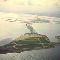
Afsluitdijk with the Wadden Sea (a part of the North Sea) on the left and the IJsselmeer on the right
The Afsluitdijk (Dutch:[ˈɑfslœydɛik]ⓘ; West Frisian: Ofslútdyk[ˈɔfslyːdik]; "closure dyke"[a]) is a major dam and causeway in the Netherlands. It was constructed between 1927 and 1932 and runs from Den Oever in North Holland province to the village of Zurich in Friesland province, over a length of 32 kilometres (20mi) and a width of 90 metres (300ft), at an initial height above Amsterdam Ordnance Datum of between 6.7 metres (22ft) along the section at Friesland, and 7.4 metres (24ft) where it crosses the deep channel of the Vlieter. The height at the greater sea depths west of Friesland was required to be a minimum of 7 metres everywhere when originally constructed.
Increases to the height of the Afsluitdijk have been made several times since 1958, when height increases were undertaken during regular maintenance periods as a result of the North Sea Flood of 1953, with the section between the Stevinsluizen and Lorentzsluizensluice complexes seeing the crest level raised to 7.8 metres.[1] Major upgrade works commenced in 2019, with one of the design conditions being that only limited wave overtopping during the design storm condition be permitted. The design proposed by the successful contractor to meet this criterion will see a further increase in the height of the dam, by approximately 2 metres.[2]
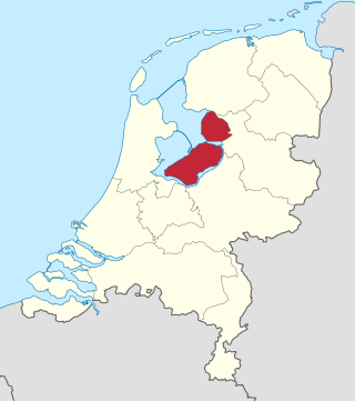
The Afsluitdijk is a fundamental part of the larger Zuiderzee Works, damming off the Zuiderzee, a salt water inlet of the North Sea, and turning it into the fresh water lake of the IJsselmeer. It is a major land reclamation project and provides a road connection between the North and West of the Netherlands.
The highway on the Afsluitdijk was the initial demonstration site for a 130km/h (81mph)speed limit in the Netherlands.[3]
History
Image from satelliteClosing the last gap 'De Vlieter' in 1932Afsluitdijk profile cross-section as designed in 1925
Reasons for construction
The Afsluitdijk (literally translated: shut-off-dyke) was completed in 1932, thereby shutting off the Zuiderzee (lit: Southern Sea) from the North Sea.[4] Until then, the Zuiderzee had been a large bay south of the North Sea which gave maritime access to five provinces of The Netherlands, and particularly during the Dutch Golden Age provided a protected entrance and exit for the harbour of Amsterdam and several other important Dutch sea harbours. Furthermore, the Zuiderzee provided relatively shallow and calm fishing grounds for the many towns bordering the bay. However, the opening of the North Sea Canal (Noordzeekanaal) in 1876 gave a much shorter direct entrance to the Amsterdam harbour, and overfishing had depleted the shallow bay. In the second half of the 19th century, the Dutch population was exploding, and there was an increasing need for land for agriculture and animal husbandry. The Dutch already had centuries of experience of building dykes around lakes, emptying them and converting them to fertile polderland.
The next large project was to convert the Zuiderzee into polder. In 1886, a few notables established the Zuiderzee Society to investigate whether reclamation was feasible. One of the most prominent members of the society was Cornelis Lely, a civil engineer, prominent member and later chairman of the society.[5] In 1891 he designed the first plan for the closure and reclamation of the Zuiderzee.
In 1913, Lely was Minister of Water Management, and land reclamation was included in the government program. His plan was initially opposed, particularly for its huge costs and also by the fishing industry. But after the flood of 1916 and the famine of 1918, opinions were ready for this mega project and the parliament agreed, but it took another 9 years, until 1927, before the works actually began.
Newsreel of the closing of the last gap
Building the dyke
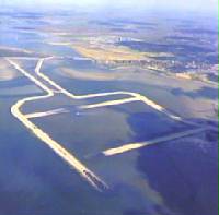
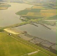
Wieringen was connected to the mainland with the short Amsteldiepdijk in 1925; the Afsluitdijk would be 32 kilometres (20 miles) in length. The inland side is heavy stone; the seaward side is boulder clay with brushwoodmattresses above, weighed down by basalt boulders and old concrete.[6] Previous experience had showed that boulder clay was superior to just sand or clay for a structure like the Afsluitdijk, with the added benefit that till was in plentiful supply in the area; it could be retrieved in large quantities by simply dredging it from the bottom of the Zuiderzee. Work started at four points: on both sides of the mainland and on two specially made construction-islands (Kornwerderzand and Breezanddijk) along the line of the future dyke.
From these points, the dyke slowly grew by ships depositing till into the open sea until it breached the surface. The nascent dyke was then strengthened from land by basalt rocks and mats of willow switch at its base. The dyke could then be finished off by raising it further with sand and finally clay for the surface of the dyke, on which grass was planted.
As the dyke grew, physicist Hendrik Antoon Lorentz calculated the force of the tide as the smaller gap made it stronger. Ten thousand workers, 27 large dredges, 13 floating cranes, 132 barges, and 88 tugs worked on the project at the end, timed to close the dyke at low tide; it was finished on 28 May 1932.[6] Construction progressed better than expected; at three points along the line of the dyke there were deeper underwater trenches where the tidal current was much stronger than elsewhere. These had been considered to be major obstacles to completing the dyke, but all of them proved to be relatively straightforward. Two years earlier than initially thought, the Zuiderzee ceased to be, as the last tidal trench, the Vlieter, was closed by a final bucket of till. The IJsselmeer was born, even though it was still salty at the time.
The dyke itself however was not finished as it still needed to be brought up to its required height and a road linking Friesland and North Holland (the current A7/E22motorway) also remained to be built. On 25 September 1933, the Afsluitdijk was officially opened, with a monument designed by architect Willem Marinus Dudok marking the spot where the dyke had been closed. The amount of material used is estimated at 23millionm3 (810millioncuft) of sand and 13.5millionm3 (480millioncuft) of till and over the years an average of around four to five thousand workers were involved with the construction every day, relieving some of the unemployment following the Great Depression.
Besides the dyke itself, there was also the necessary construction of two complexes of shipping locks and discharge sluices at both ends of the dyke. The complex at Den Oever includes the Stevin lock (named after the son of mathematician and engineerSimon Stevin, Hendrik Stevin, who was the first making a plan to close the Zuiderzee in 1667[7]) and three series of five sluices for discharging the IJsselmeer into the Wadden Sea; the other complex at Kornwerderzand is composed of the Lorentz locks (named after the physicist) and two series of five sluices, making a total of 25 discharge sluices. It is necessary to routinely discharge water from the lake since it is continually fed by rivers and streams (most notably the IJssel river that gives its name to the lake) and polders draining their water into the IJsselmeer.
Developments after construction and height increases
The height of the crest of the Afsluitdijk was originally determined based on insufficient data about wave run-up. This became apparent soon after the first significant storm surge following the completion of the works, which occurred in December 1936. During the storm, the water in the Wadden Sea reached to around half a metre below the dike. For the crown height, storm surge heights indicated by the Staatscommissie Lorentz (SCL)(English: Lorentz State Commission) were primarily used, based on storm surges that had occurred in the period 1825–1926.[1][8]
According to committee's predictions, if the Zuiderzee had been closed during the 1825–1926 period, the highest water level reached would have been 3.1 metres above Amsterdam Ordnance Datum at Den Oever, and about 3.4 metres on the Friesland coast. However, the commission drew attention to the fact that in a very rare and unfavourable set of circumstances, even higher storm surge heights were possible.[8]
Observed storm surge water levels in 1894 for various locations in the Netherlands, and calculated levels of the same locations with a closed-off Zuiderzee
Key to table
Z
Water level reached during storm in 1894
Δ
Calculated level increase with new dike
A
Calculated level with closed-off Zuiderzee
ΔG
Predicted increase in wave run-up.
All values in centimetres. Z and A are in centimetres above NAP (Normaal Amsterdams Peil/Amsterdam Ordnance Datum).[1]
Location of the area or tide gauge
Z
Δ
A
ΔG
Kaaphoofd
250
43
293
0
Den Helder, gauge
248
44
292
0
Oostoever
260
48
308
15
Westerland (Wieringen)
247
79
326
15
Den Oever
233
113
346
25
Kornwerderzand
270
100
370
(15)
Harlingen
269
77
346
15
Nieuw Bildt
271
13
284
5
Ameland, Waddenkust
330
8
335
0
Terschelling, Waddenkust east
340
0
325
0
Terschelling, harbour
286
14
300
0
Vlieland, harbour
287
16
303
0
Vlieland Waddenkust, Posthuis
260
32
292
10
Eierland near Cocksdorp
280
30
310
0
Texel, Oostkaap
245
79
324
10
Texel, Oudeschild
254
65
319
10
Texel, South Point
240
50
290
0
The lower value was based on the assumption that wave run-up in the shallow area near the Frisian coast would be reduced. However, it became evident as early as 1934 that this assumption was incorrect due to the narrowness of the shallow zone. To address this issue, a section of the dike body was removed. Despite these adjustments, a 1937 storm revealed that they were insufficient, leading to an increase in the crest height to 7.4 metres.
In determining the height for the construction of the inner berm, different considerations were employed compared to those for the main dam crest height. The primary requirement for the crest was to ensure the dike would not be breached during the most severe anticipated storm. To achieve this, the crest was designed to be elevated enough so that, at most, only a single wave could reach it. The IJsselmeer side of the dam was designed with a lower factor of safety than the Wadden Sea side, as it was anticipated that even under unfavourable conditions, such as a southwest storm over the IJsselmeer with a high average water level, the waves would not exceed about 3.5 metres above Amsterdam Ordnance Datum. Consequently, the berm was constructed to a height of approximately 4 metres.[1]
The inner berm slope toward the future water level of the IJsselmeer (or Amstelmeer) was designed to be steeper than the outer slope, with a ratio of approximately 1:3. The majority of the dam's core consisted of sand, while boulder clay on the exterior provided resistance against water flow, limiting seepage and enhancing dike breach protection. A layer of armourstone, composed of basalt rock, was utilized on the outer slope.[1][8]
During construction, the slopes were partially fortified with basalt columns and Belgian block stone Belgische Bloksteen, a block-shaped, hard variety of limestone. Block stone served as a more affordable and widely available alternative to basalt, and the Dutch Government resisted purchasing large quantities of basalt to avoid potential price increases, instead planning to gradually replace the block stone with basalt.[1]
Following the 1953 storm, a subsequent storm in 1954 caused significant damage to the Afsluitdijk. Although the 1953 water level was not as extreme at the Afsluitdijk as in the southern Netherlands, the intense wave action resulted in severe damage to a large portion of the block stone, which was later replaced by basalt. In response to recommendations from the Deltacommissie, the commission responsible for the Delta Works, it was deemed necessary to elevate the dike level. However, this was considered less urgent compared to the issues in Zeeland after the 1953 storm. A decision was made to prioritize the Delta Works while also incrementally increasing the Afsluitdijk height to 7.4 metres.[1][8]
A cross section profile of the Afsluitdijk prior to the upgrade works commenced in 2019
On 23 September 1954, on the centenary of Cornelis Lely, a statue, made by Mari Andriessen, was unveiled by Queen Juliana on the North Holland side of the Afsluitdijk. On May 9, 2007, the statue was relocated near to the Vlieter Monument. The official unveiling, on the occasion of the 75th anniversary of the dyke, was performed on 24 May 2007 by Prince Willem-Alexander.
Observation tower as seen from pedestrian bridge
In 2012, the State Secretary for Infrastructure and the Environment, Joop Atsma, issued a statement detailing the factors influencing the decision to replace the locks at Kornwerderzand. A naviduct would have a high construction cost compared with standard locks and bridges, but would benefit the economy by reducing delays. After the cost–benefit analysis of all potential solutions was considered, a decision was made to strengthen the existing locks. However, it is quite possible that a naviduct will be built to replace the locks when they reach the end of their useful life in 2050.[12] The work started in April 2020 and was planned to take three years; during the work, the highway remained in operation, however the bicycle path was closed.[13]
The new (2022) profile (Den Oever - Kornwerderzand)The new (2022) profile (Kornwerderzand - Friese Kust)
Rijkswaterstaat (the ministry which oversees the dyke) further increased the height of the dyke beginning in 2018. As part of the renovation program, a series of artistic projects were incorporated into the dyke, known as the "Icoon Afsluitdijk." Daan Roosegaarde led the artistic aspects. The three designs of light and interaction developed by Roosegaarde and his team are entitled Gates of Light, Windvogel and Glowing Nature.[14][15] The improvement of the main dike body was completed in 2022. Additional works (the fish migration river,[16] new locks and the pumping station) were at that moment not yet ready.[needs update]
Provision for a railway line linking North Holland and Friesland (between Anna Paulowna and Harlingen) had been included on the Afsluitdijk, in the form of a linear reservation, along with extra drawbridge abutments at the locks. However, construction of the line was never undertaken by the Dutch track operator (ProRail), for reasons of cost and relative lack of benefits. The reservation and abutments for the rail line were utilized instead for a second carriageway for the dyke's two-lane highway in the 1970s, transforming the latter into today's four-lane A7 motorway.
Flevoland is the twelfth and newest province of the Netherlands, established in 1986, when the southern and eastern Flevopolders, together with the Noordoostpolder, were merged into one provincial entity. It is in the centre of the country in the former Zuiderzee, which was turned into the freshwater IJsselmeer by the closure of the Afsluitdijk in 1932. Almost all of the land belonging to Flevoland was reclaimed in the 1950s and 1960s while splitting the Markermeer and Bordering lakes from the IJsselmeer. As to dry land, it is the smallest province of the Netherlands at 1,410 km2 (540 sq mi), but not gross land as that includes much of the waters of the fresh water lakes (meres) mentioned.
The IJsselmeer, also known as Lake IJssel in English, is a closed-off freshwater lake in the central Netherlands bordering the provinces of Flevoland, North Holland and Friesland. It covers an area of 1,100 km2 (420 sq mi) with an average depth of 4.5 m (15 ft). The river IJssel, after which the lake was named, flows into the IJsselmeer.
The Zuiderzee or Zuider Zee, historically called Lake Almere and Lake Flevo, was a shallow bay of the North Sea in the northwest of the Netherlands. It extended about 100 km inland and at most 50 km wide, with an overall depth of about 4 to 5 metres (13–16 feet) and a coastline of about 300 km. It covered 5,000 km2 (1,900 sq mi). Its name is Dutch for "southern sea", indicating that the name originates in Friesland, to the north of the Zuiderzee.
The Zuiderzee Works is a system of dams and dikes, land reclamation and water drainage work, which was the largest hydraulic engineering project undertaken by the Netherlands during the twentieth century. The project involved the damming of the Zuiderzee, a large, shallow inlet of the North Sea, and the reclamation of land in the newly enclosed water using polders. Its main purposes are to improve flood protection and create additional land for agriculture.
The Delta Works is a series of construction projects in the southwest of the Netherlands to protect a large area of land around the Rhine–Meuse–Scheldt delta from the sea. Constructed between 1954 and 1997, the works consist of dams, sluices, locks, dykes, levees, and storm surge barriers located in the provinces of South Holland and Zeeland.
Den Oever is a village in the Dutch province of North Holland. It is a part of the municipality of Hollands Kroon, and lies about 18 kilometres (11 mi) east of Den Helder.
St. Lucia's flood (Sint-Luciavloed) was a storm tide that affected the Netherlands and Northern Germany on 13/14 December 1287 (OS), St. Lucia Day and the day after, killing approximately 50,000 to 80,000 people in one of the largest floods in recorded history. A low-pressure system mixed with a high tide caused the North Sea to rise over the seawalls and dikes, causing a large portion of the Netherlands and Northern Germany to be flooded.
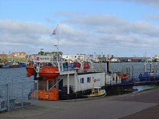
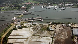
Kornwerderzand is a village on the Afsluitdijk, a major dam in the Netherlands that links Friesland with North Holland.
Flood control is an important issue for the Netherlands, as due to its low elevation, approximately two thirds of its area is vulnerable to flooding, while the country is densely populated. Natural sand dunes and constructed dikes, dams, and floodgates provide defense against storm surges from the sea. River dikes prevent flooding from water flowing into the country by the major rivers Rhine and Meuse, while a complicated system of drainage ditches, canals, and pumping stations keep the low-lying parts dry for habitation and agriculture. Water control boards are the independent local government bodies responsible for maintaining this system.
Breezanddijk is a small community that lies near the midpoint of the Afsluitdijk, part of the A7 motorway, in the Netherlands. It is located on a former artificial island which was created during the construction of the dam, and it belongs to the municipality of Súdwest-Fryslân, in Friesland province. The hamlet lies between Den Oever and Kornwerderzand.
The Battle of the Afsluitdijk of 12–14 May 1940 was an unsuccessful attempt by German Wehrmacht forces to seize the Afsluitdijk during the invasion of the Netherlands. German invasion plans called for a simultaneous attack on Vesting Holland from multiple directions, expecting to capture the country's capital and most important region in a day's time.
The Houtribdijk is a dam in the Netherlands, built between 1963 and 1976 as part of the Zuiderzee Works, which connects the cities of Lelystad and Enkhuizen. On the west side of the dike is the Markermeer and on the east is the IJsselmeer. The 26-kilometer-long dike was intended for the Markerwaard, but the construction of this polder was abandoned in 2003 due to environmental concerns. The Houtribdijk was widened and reinforced between 2017 and 2020.
The Markermeer is a 700 km2 (270 sq mi) lake in the central Netherlands in between North Holland, Flevoland, and its smaller and larger neighbors, the IJmeer and IJsselmeer. A shallow lake at 3 to 5 m in depth, matching the reclaimed land to its west, north-west and east it is named after the small former island, now peninsula, of Marken on its west shore.
The Philipsdam is a compartmentalisation dam constructed as part of the Delta Works in the Netherlands. It separates water of the lakes Krammer and Volkerak from the Oosterschelde, and connects the Grevelingendam to Sint Philipsland.
A naviduct is a special class of navigable aqueduct, in which the waterway also includes a lock. One example of a naviduct has been built at Enkhuizen on the Houtribdijk in the Netherlands on the instructions of the Rijkswaterstaat. This cost over €55 million and was completed in 2003. It is big enough to simultaneously transfer two large Rhine river-barges from the Markermeer to the IJsselmeer or vice versa. The structure was chosen because a busy waterway crosses a dam carrying a busy road, but the space available for separate aqueduct and lock facilities was restricted.
The Markiezaatskade is a compartmentalisation dam in The Netherlands, situated between South Beveland and Molenplaat, near Bergen op Zoom. The dam was constructed as part of the Delta Works, and has a length of 4 kilometres.
The Oranje Locks are a group of locks and other water management facilities just east of Amsterdam.
The Stormvloedkering Hollandse IJssel, Hollandse IJsselkering or Algerakering is a storm surge barrier located on the Hollandse IJssel, at the municipal boundary of Capelle aan den IJssel and Krimpen aan den IJssel, east of Rotterdam in The Netherlands. The construction of the works comprised the first project of the Delta Works, undertaken in response to the disastrous effects of the North Sea flood of 1953. Prior to 1954, the spelling Hollandsche was used in the official name.
The Zandkreekdam is a compartmentalisation dam located approximately 3 kilometres north of the city of Goes in The Netherlands, which connects Zuid-Beveland with Noord-Beveland, and separates the Oosterschelde from the Veerse Meer.
Pieter Jacobus (P.J.) Wemelsfelder was a Dutch hydraulic engineer who made significant contributions to the field of hydrometry in the Netherlands, and in hydraulic engineering internationally. In addition to his involvement in the design and planning of the Delta Works, he published widely and is notable for the first use of probability theory in the design of flood levels.
↑ Rijkswaterstaat, Ministerie van Infrastructuur en Waterstaat. "Project Afsluitdijk"["Afsluitdijk Project"]. www.rijkswaterstaat.nl (in Dutch). Retrieved 4 April 2023.
↑ "Holland's first 130km/h road is the Afsluitdijk". DutchNews.nl. 1 March 2011. Retrieved 20 February 2012. The speed limit on the Afsluitdijk, the stretch of the A7 on the dyke between Wognum in North Holland and Zürich in Friesland, has been increased to 130km/h from Tuesday.
↑ Hakkenes, Emiel (2017). Polderkoorts. Hoe de Zuiderzee verdween [Polder Fever. How the Zuyderzee disappeared]. Amsterdam: Uitgeverij Thomas Rap.
↑ Banning, Cees (2018). Cornelis Lely. Ingenieur van het nieuwe Nederland [In Dutch: Cornelis Lely - Engineer of the new Netherlands]. Beilen, NL: Uitgeverij Pharos.
1 2 Ley, Willy (October 1961). "The Home-Made Land". For Your Information. Galaxy Science Fiction. pp.92–106.
↑ Stevin, Hendrik (1667). Wisconstich filosofisch bedryf[mathematical and philosofical transactions] (in Dutch). Philips de Cro, Leiden.
↑ Vreugdenhil, C. B.; Alberts, Gerard; Gelder, Pieter van (2001). "Waterloopkunde: een eeuw wiskunde en werkelijkheid"[Hydraulics: A century of mathematics and reality]. Nieuw Archief voor Wiskunde (in Dutch). S 5, dl 2 (3): 266–276. ISSN0028-9825. Retrieved 3 April 2023.
This page is based on this Wikipedia article Text is available under the CC BY-SA 4.0 license; additional terms may apply. Images, videos and audio are available under their respective licenses.