Delta Works

Last updated • 9 min readFrom Wikipedia, The Free Encyclopedia

The Delta Works (Dutch : Deltawerken) is a series of construction projects in the southwest of the Netherlands to protect a large area of land around the Rhine–Meuse–Scheldt delta from the sea. Constructed between 1954 and 1997, the works consist of dams, sluices, locks, dykes, levees, and storm surge barriers located in the provinces of South Holland and Zeeland.

Contents

The aim of the dams, sluices, and storm surge barriers was to shorten the Dutch coastline, thus reducing the number of dikes that had to be raised. Along with the Zuiderzee Works, the Delta Works have been declared one of the Seven Wonders of the Modern World by the American Society of Civil Engineers.

History

Newsreel from 1959 on the advantages and disadvantages of the Delta Works

Due to indecision and the Second World War, little action was taken. In 1950 two small estuary mouths, the Brielse Gat near Brielle and the Botlek near Vlaardingen were dammed. After the North Sea flood of 1953, a Delta Works Commission was installed to research the causes and develop measures to prevent such disasters in future. They revised some of the old plans and came up with the "Deltaplan".

Delta law and conceptual framework

Zeeland Bridge Colijnsplaat - Zeelandbrucke.jpg
Zeeland Bridge
Oosterscheldekering Oosterscheldekering-pohled.jpg
Oosterscheldekering

An important part of this project was fundamental research to come up with long-term solutions, protecting the Netherlands against future floods. Instead of analysing past floods and building protection sufficient to deal with those, the Delta Works commission pioneered a conceptual framework to use as norm for investment in flood defences.

The framework is called the 'Delta norm'; it includes the following principles:

The most important "dike ring area" is the South Holland coast region. It is home to four million people, most of whom live below normal sea level. The loss of human life in a catastrophic flood here can be very large because there is typically little warning time with North Sea storms. Comprehensive evacuation is not a realistic option for the Holland coastal region.

The commission initially set the acceptable risk for complete failure of every "dike ring" in the country at 1 in 125,000 years. But, it found that the cost of building to this level of protection could not be supported. It set "acceptable" risks by region as follows:

River flooding causes less damage than salt water flooding, which causes long-term damage to agricultural lands. Areas at risk from river flooding were assigned a higher acceptable risk. River flooding also has a longer warning time, producing a lower estimated death toll per event.

These acceptable risks were enshrined in the Delta Law (Dutch: Deltawet). This required the government to keep risks of catastrophic flooding within these limits and to upgrade defences should new insights into risks require this. The limits have also been incorporated into the new Water Law (Waterwet), effective from 22 December 2009.

The Delta Project (of which the Delta Works are a part) has been designed with these guidelines in mind. All other primary defences have been upgraded to meet the norm. New data elevating the risk assessment on expected sea level rise due to global warming has identified ten 'weak points.' These have been upgraded to meet future demands. The latest upgrades are made under the High Water Protection Program.

Alterations to the plan during the execution of the Works

Scale model of the Maeslantkering Schaalmodel Maeslantkering.jpg
Scale model of the Maeslantkering

During the execution of the works, changes were made in response to public pressure. In the Nieuwe Waterweg, the heightening and the associated widening of the dikes proved very difficult because of public opposition to the planned destruction of important historic buildings to achieve this. The plan was changed to the construction of a storm surge barrier (the Maeslantkering) and dikes were only partly built up.

The storm-surge barrier

The Delta Plan originally intended to create a large freshwater lake, the Zeeuwse Meer (Zeeland Lake). [1] This would have caused major environmental destruction in Oosterschelde, with the total loss of the saltwater ecosystem and, consequently, the harvesting of oysters. Environmentalists and fishermen combined their efforts to prevent the closure; they persuaded parliament to amend the original plan. Instead of completely damming the estuary, the government agreed to build a storm surge barrier. This essentially is a long collection of very large valves that can be closed against storm surges.

The storm surge barrier closes only when the sea-level is expected to rise 3 metres above mean sea level. Under normal conditions, the estuary's mouth is open, and salt water flows in and out with the tide. As a result of the change, the weak dikes along the Oosterschelde needed to be strengthened. Over 200 km of the dike needed new revetments. The connections between the Eastern Scheldt and the neighboring Haringvliet had to be dammed to limit the effect of the salt water. Extra dams and locks were needed at the east part of the Oosterschelde to create a shipping route between the ports of Rotterdam and Antwerp. Since operating the barrier has an effect on the environment, fisheries and the water management system, decisions made on opening or closing the gate are carefully considered. Also the safety of the surrounding dykes are affected by barrier operations.

Environmental policy implementations

In an attempt to restore and preserve the natural system surrounded by the dykes and storm-surge barrier, the concept 'building with nature' was introduced in revised Delta Program updates after 2008. The new integrated water management plan not only takes into account protection against flooding, but also covers water quality, leisure industry, economic activities, shipping, environment and nature. Whenever possible, existing engineering constructions would be replaced by more 'nature friendly' options in an attempt to restore natural estuary and tides, while still protecting against flooding. [2] In addition, building components of the reinforcements are designed in a way that they support formation of entire ecosystems. [3] As part of the revision, the Room for the River projects, enabled nature to occupy space by lowering or widening the river bed. [4] In order to establish this, agricultural flood plains are turned into natural parks, excavated farmland is used for wild vegetation and newly excavated lakes and bypasses create habitats for fish and birds. [5] Along the coast, natural sand is added each year to allow sand to blow freely through the dunes instead of having the dunes held in place by planted vegetation or revetments. [6] Although the new plan brought along additional cost, it was received favourably.[ citation needed ] The re-considerations of the Delta Project indicated the growing importance of integrate environmental impact assessments in policy-making.

Environmental effects

The Delta Project of which the Delta Works are part of was originally designed in a period of time when environmental awareness and ecological effects of engineering projects were barely taken into consideration. [7] Although the level of awareness for the environment grew throughout the years, the Delta Project has caused numerous irreversible[ citation needed ] effects on the environment in the past. Blocking the estuary mouths did reduce the length of dykes that otherwise would have to be built to protect against floods, but it also led to major changes in the water systems. For example, the tides disappeared, which resulted in a less smooth transition from sea water into fresh water. Flora and fauna suffered from this noticeable change. [8] In addition, rivers experienced an increase in sedimentation by polluted sludge, since there was no longer an open passage to the sea.

Project costs

The projects of the Delta Plan are financed with the Delta Fund. In 1958, when the Delta law was accepted under the Delta Works Commission, the total costs were estimated at 3.3 billion guilder. This was at that time equal to 20% of national GDP. This amount was spread out over the 25 years that it would take to complete the massive engineering project. The Delta works were mostly financed by the national budget, with a contribution of the Marshall Plan of 400 million guilder. In addition, the Dutch natural gas discovery contributed massively to the finance of the project. At completion in 1997, costs were set on 8.2 billion guilder. [9] Nevertheless, in 2012 the total costs were already set on[ clarification needed ] around $13 billion. [10]

Current status

The original plan was completed by the Europoortkering which required the construction of the Maeslantkering in the Nieuwe Waterweg between Maassluis and Hook of Holland and the Hartelkering in the Hartel Canal near Spijkenisse. The works were declared finished after almost forty years in 1997.

Due to climate change and relative sea-level rise, the dikes will eventually have to be made higher and wider. This is a long term uphill battle against the sea. The needed level of flood protection and the resulting costs are a recurring subject of debate, and involve a complicated decision-making process. In 1995 it was agreed in the Delta Plan Large Rivers and Room for the River projects that about 500 kilometres of insufficient dyke revetments were reinforced and replaced along the Oosterschelde and Westerschelde between 1995 and 2015. After 2015, under the High Water Protection Program, additional upgrades are made. [11]

In September 2008, the Delta Commission presided by politician Cees Veerman advised in a report that the Netherlands would need a massive new building program to strengthen the country's water defenses against the anticipated effects of global warming for the next 190 years. The plans included drawing up worst-case scenarios for evacuations and included more than €100 billion, or $144 billion, in new spending through the year 2100 for measures, such as broadening coastal dunes and strengthening sea and river dikes. The commission said the country must plan for a rise in the North Sea of 1.3 meters by 2100 and 4 meters by 2200. [12]

Projects

Delta Works

The works that are part of the Delta Works are listed in chronological order with their year of completion:

Delta Works
ProjectBeginningInaugurationImageFunctionWatercoursePlace
Stormvloedkering Hollandse IJssel (Algerakering)19541958 1-Stormvloedkering Hollandse IJssel-Algerabrug--DSC 0179.jpg Flood barrier Hollandse IJssel (river) South Holland near Krimpen aan den IJssel
Zandkreekdam 19591960 Zandkreekdam-01.jpg Dam Zandkreek, Veerse Gat (Oosterschelde)Between Noord-Beveland and Zuid-Beveland in the east
Veerse Gatdam 19601961 Veerse Dam.jpg Dam Veerse Gat (Oosterschelde)Between Noord-Beveland and Walcheren in the west
Grevelingendam 19581965 Grevelingedam-01.jpg Dam Grevelingenmeer Between Tholen and Schouwen-Duiveland
Volkerakdam 19571969 Volkerakdam-01.jpg Dam Volkerak, Hollands Diep Meuse and Oosterschelde Between South Holland and Zeeland
Haringvlietdam 19581971 Haringvlietdam 2006 06 18-2.jpg Dam / Flood barrier Haringvliet (Rhine and Meuse)Between Voorne-Putten and Goeree-Overflakkee
Brouwersdam 19641971 Brouwersdam-02.jpg Dam Grevelingenmeer Between Goeree-Overflakkee and Schouwen-Duiveland
Markiezaatskade 19801983 Markiezaatskade-03.jpg Dam Scheldt–Rhine Canal, Markiezaatsmeer Between Zuid-Beveland and Molenplaat
Oosterscheldekering 19601986 Oosterscheldekering-pohled.jpg Flood barrier Oosterschelde Between Schouwen-Duiveland and Noord-Beveland
Oesterdam 19791987 Oesterdam-02.jpg Dam Oosterschelde, Scheldt–Rhine Canal Between Tholen and Zuid-Beveland
Philipsdam 19761987 Philipsdam-03.jpg Dam Oosterschelde Between Grevelingendam and Sint Philipsland
Bathse spuisluis 19801987 Spuisluis Bath-03.jpg Lock Volkerak, Markiezaatsmeer, Oosterschelde Bath, Zeeland
Maeslantkering 19881997 Maeslantkering.jpg Flood barrier Nieuwe Waterweg (Rhine)Downstream Rotterdam South Holland
Hartelkering 19911997 Spijkenisse - Hartelkering gesloten.jpg Flood barrier Hartelkanaal Near Spijkenisse, South Holland

See also

Related Research Articles

<span class="mw-page-title-main">Eastern Scheldt</span> Estuary in Zeeland, Netherlands

The Eastern Scheldt is a former estuary in the province of Zeeland, Netherlands, between Schouwen-Duiveland and Tholen on the north and Noord-Beveland and Zuid-Beveland on the south. It also features the largest national park in the Netherlands, founded in 2002.

<span class="mw-page-title-main">Goeree-Overflakkee</span> Island and Municipality in South Holland, Netherlands

Goeree-Overflakkee is the southernmost delta island of the province of South Holland, Netherlands. It is separated from Voorne-Putten and Hoeksche Waard by the Haringvliet, from the mainland of North Brabant by the Volkerak, and from Schouwen-Duiveland by Lake Grevelingen.

<span class="mw-page-title-main">Maeslantkering</span> Dutch storm surge barrier

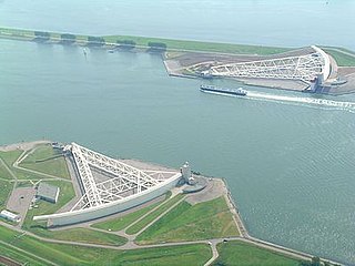
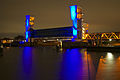
The Maeslantkering is a storm surge barrier on the Nieuwe Waterweg, in South Holland, Netherlands. It was constructed from 1991 to 1997. As part of the Delta Works the barrier responds to water level predictions calculated by a centralized computer system called BOS. It automatically closes when Rotterdam is threatened by floods.

<span class="mw-page-title-main">North Sea flood of 1953</span> Late January-early February 1953 North sea flood storm

The 1953 North Sea flood was a major flood caused by a heavy storm surge that struck the Netherlands, north-west Belgium, England and Scotland. Most sea defences facing the surge were overwhelmed, resulting in extensive flooding.

<span class="mw-page-title-main">De Biesbosch National Park</span>

De Biesbosch National Park is one of the largest national parks in the Netherlands and one of the last extensive areas of freshwater tidal wetlands in Northwestern Europe. The Biesbosch consists of a large network of rivers and smaller and larger creeks with islands. The vegetation is mostly willow forests, although wet grasslands and fields of reed are common as well. The Biesbosch is an important wetland area for waterfowl and has a rich flora and fauna. It is especially important for migrating geese.

<span class="mw-page-title-main">Oosterscheldekering</span> Dutch storm surge barrier in the North Sea

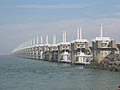
The Oosterscheldekering, between the islands Schouwen-Duiveland and Noord-Beveland, is the largest of the Delta Works, a series of dams and storm surge barriers, designed to protect the Netherlands from flooding from the North Sea. The construction of the Delta Works was a response to the widespread damage and loss of life in the North Sea flood of 1953.

<span class="mw-page-title-main">Flood barrier</span> Floodgate designed to prevent a storm surge

A flood barrier, surge barrier or storm surge barrier is a specific type of floodgate, designed to prevent a storm surge or spring tide from flooding the protected area behind the barrier. A surge barrier is almost always part of a larger flood protection system consisting of floodwalls, levees, and other constructions and natural geographical features. Flood barrier may also refer to barriers placed around or at individual buildings to keep floodwaters from entering the buildings.

<span class="mw-page-title-main">Flood control in the Netherlands</span> Manmade control of flooding in the Netherlands

Flood control is an important issue for the Netherlands, as due to its low elevation, approximately two thirds of its area is vulnerable to flooding, while the country is densely populated. Natural sand dunes and constructed dikes, dams, and floodgates provide defense against storm surges from the sea. River dikes prevent flooding from water flowing into the country by the major rivers Rhine and Meuse, while a complicated system of drainage ditches, canals, and pumping stations keep the low-lying parts dry for habitation and agriculture. Water control boards are the independent local government bodies responsible for maintaining this system.

<span class="mw-page-title-main">Philipsdam</span> Hydraulic engineering structures in the Netherlands

The Philipsdam is a compartmentalisation dam constructed as part of the Delta Works in the Netherlands. It separates water of the lakes Krammer and Volkerak from the Oosterschelde, and connects the Grevelingendam to Sint Philipsland.

<span class="mw-page-title-main">Johan van Veen</span> Dutch engineer (1893–1959)

Johan van Veen was a Dutch hydraulic engineer. He is considered the father of the Delta Works.

<span class="mw-page-title-main">Oesterdam</span> Compartmentalisation dam in the Netherlands, part of the Delta Works

The Oesterdam is a compartmentalisation dam in The Netherlands, situated between Tholen and South Beveland in the eastern part of the Eastern Scheldt. The dam, with a length of 10.5 kilometres, is the longest structure built for the Delta Works. The Oesterdam was necessitated, like the Philipsdam, after the decision was taken to close off the Eastern Scheldt with a storm surge barrier, rather than a solid dam.

<span class="mw-page-title-main">Markiezaatskade</span> Dam in the Netherlands

The Markiezaatskade is a compartmentalisation dam in The Netherlands, situated between South Beveland and Molenplaat, near Bergen op Zoom. The dam was constructed as part of the Delta Works, and has a length of 4 kilometres.

<span class="mw-page-title-main">Volkerakdam</span> Hydraulic engineering structures in the Netherlands

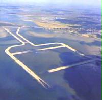
The Volkerakdam or Volkerakwerken is the name given to a group of hydraulic engineering structures between Goeree-Overflakkee and North Brabant in the Netherlands. The works are not a single dam, but are composed of three distinct structures: a dam between Goeree-Overflakkee and Hellegatsplein, a series of locks from Hellegatsplein to North Brabant, and a bridge from Hellegatsplein to Hoekse Waard. The works cross three separate bodies of water: the Haringvliet, Hollands Diep and Volkerak. The works together comprise the fifth project of the Delta Works.

<span class="mw-page-title-main">Grevelingendam</span> Hydraulic engineering structures in the Netherlands

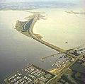
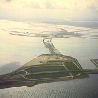
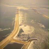
The Grevelingendam is a dam located in the Grevelingen sea inlet between Schouwen-Duiveland and Goeree-Overflakkee in The Netherlands. The Grevelingendam was the fourth structure constructed as part of the Delta Works.

<span class="mw-page-title-main">Stormvloedkering Hollandse IJssel</span> Hydraulic engineering structure in the Netherlands

The Stormvloedkering Hollandse IJssel, Hollandse IJsselkering or Algerakering is a storm surge barrier located on the Hollandse IJssel, at the municipal boundary of Capelle aan den IJssel and Krimpen aan den IJssel, east of Rotterdam in The Netherlands. The construction of the works comprised the first project of the Delta Works, undertaken in response to the disastrous effects of the North Sea flood of 1953. Prior to 1954, the spelling Hollandsche was used in the official name.

<span class="mw-page-title-main">Zandkreekdam</span> Hydraulic engineering structures in the Netherlands

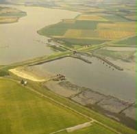
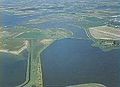
The Zandkreekdam is a compartmentalisation dam located approximately 3 kilometres north of the city of Goes in The Netherlands, which connects Zuid-Beveland with Noord-Beveland, and separates the Oosterschelde from the Veerse Meer.

<span class="mw-page-title-main">Frank Spaargaren</span> Dutch civil engineer

Frank Spaargaren was a Dutch hydraulic engineer who was one of the main designers of the Oosterscheldekering and served as a director of the Waterloopkundig Laboratorium in Delft.

A compartmentalisation dam is a dam that divides a body of water into two parts. A typical use of such a dam is the regulation of water levels separately in different sections of a basin. One application of a compartmentalisation dam is to facilitate closures of areas with multiple tidal inlets, such as in the case of the Delta Works.

<span class="mw-page-title-main">Closure of tidal inlets</span> Man-made coastal barriers against tides

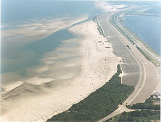
In coastal and environmental engineering, the closure of tidal inlets entails the deliberate prevention of the entry of seawater into inland areas through the use of fill material and the construction of barriers. The aim of such closures is usually to safeguard inland regions from flooding, thereby protecting ecological integrity and reducing potential harm to human settlements and agricultural areas.

<span class="mw-page-title-main">Pieter Abraham van de Velde</span> Dutch civil engineer and professor of hydraulic and road engineering

Pieter Abraham van de Velde was a Dutch civil engineer and professor of road and hydraulic engineering. He contributed to several major water engineering projects in the Netherlands, notably the drainage of Walcheren at the end of the Second World War, dike restorations following the 1953 North Sea flood, and the Deltaplan.

References

  1. Ley, Willy (October 1961). "The Home-Made Land". For Your Information. Galaxy Science Fiction. pp. 92–106.
  2. Kabat, Pavel; Fresco, Louise; Stive, Marcel J.F.; Veerman, Cees P.; van Alphen, Jos S.L.J.; Parmet, Bart W. A. H.; Hazeleger, Wilco; Katsman, Caroline A. (July 2009). "Dutch coasts in transition". Nature Geoscience. 2 (7): 450–451. Bibcode:2009NatGe...2..450K. doi:10.1038/ngeo572.
  3. Deltares (2014). "Bouwen met de natuur in de praktijk". Delta Life. 1: 14–15.
  4. Van Buuren, A; Ellen, G.J.; Warner, J.F. (2016). "Path-dependency and policy learning in the Dutch delta: toward more resilient flood risk management in the Netherlands?". Ecology and Society. 21 (4). doi: 10.5751/es-08765-210443 .
  5. Rijcken, Ties (2015). "A critical approach to some new ideas about the Dutch flood risk system". Research in Urbanism Series. 3 (1).
  6. DGW. "Nationaal Waterplan". rijksoverheid.nl. Ministerie van Infrastructuur en Milieu. Archived from the original on September 26, 2015.
  7. d'Angremond, K (2003). "From disaster to Delta Project: the storm flood of 1953". Terra Aqua. 90 (3).
  8. de Vos, Art (2006). Nederland: een natte geschiedenis. Schiedam: Scriptum Publishers. p. 96. ISBN   90-5594-487-4.
  9. Aerts, J.C.J.H. (2009). Adaptation cost in the Netherlands: Climate Change and flood risk management. Climate Changes Spatial Planning and Knowledge for Climate. pp. 34–36. ISBN   9789088150159.
  10. Higgins, Andrew (15 November 2012). "Lessons for U.S. From a Flood-Prone Land". The New York Times. Retrieved 13 April 2018.
  11. Rijcken, T (2015). "A critical approach to some new ideas about the Dutch flood risk system". Research in Urbanism Series. 3 (1). doi:10.7480/rius.3.842. S2CID   110283338.
  12. "Dutch draw up drastic measures to defend coast against rising seas". The New York Times. 3 August 2008. Retrieved 20 October 2010.

51°39′N3°43′E / 51.65°N 3.72°E / 51.65; 3.72