
The Rhine is one of the major European rivers. The river begins in the Swiss canton of Graubünden in the southeastern Swiss Alps. It forms the Swiss-Liechtenstein border and partly the Swiss-Austrian and Swiss-German borders. After that the Rhine defines much of the Franco-German border, after which it flows in a mostly northerly direction through the German Rhineland. Finally in Germany, the Rhine turns into a predominantly westerly direction and flows into the Netherlands where it eventually empties into the North Sea. It drains an area of 9,973 km2.

Batavia is a historical and geographical region in the Netherlands, forming large fertile islands in the river delta formed by the waters of the Rhine and Meuse rivers. During the Roman Empire, it was an important frontier region and source of imperial soldiers. Its name is possibly pre-Roman.

The Waal is the main distributary branch of the river Rhine flowing approximately 80 km (50 mi) through the Netherlands. It is the major waterway connecting the port of Rotterdam to Germany. Before it reaches Rotterdam, it joins with the Afgedamde Maas near Woudrichem to form the Boven Merwede. Along its length, Nijmegen, Tiel, Zaltbommel and Gorinchem are towns of importance with direct access to the river.

The IJssel is a Dutch distributary of the river Rhine that flows northward and ultimately discharges into the IJsselmeer, a North Sea natural harbour. It more immediately flows into the east-south channel around the Flevopolder, Flevoland which is kept at 3 metres below sea level. This body of water is then pumped up into the IJsselmeer.

The Afgedamde Maas is a former distributary of the Maas River in the Dutch provinces of North Brabant and Gelderland. The Maas splits near Heusden with one channel flowing north until its confluence with the river Waal to form the Merwede, while the other channel continues west as the main distributary of the Maas.

The Linge is a river in the Betuwe that is 99.8 km long, which makes it one of the longest rivers that flow entirely within the Netherlands.

The Lek is a river in the western Netherlands of some 60 km (37 mi) in length. It is the continuation of the Nederrijn after the Kromme Rijn branches off at the town of Wijk bij Duurstede. The main westbound waterway is hereafter called the Lek River. The Nederrijn is, itself, a distributary branch of the river Rhine.

The Nederrijn is the Dutch part of the Rhine from the confluence at the town of Angeren of the cut-off Rhine bend of Oude Rijn (Gelderland) and the Pannerdens Kanaal. The city of Arnhem lies on the right (north) bank of the Nederrijn, just past the point where the IJssel branches off. The Nederrijn flows on to the city of Wijk bij Duurstede, from where it continues as the Lek. The once-important but now small Kromme Rijn branch carries the name "Rhine" towards the city of Utrecht.

Oude Rijn is the name of a long former bend in river Rhine in the Dutch province of Gelderland.

The Bijlands Kanaal is a canal in the Dutch province of Gelderland, near the Dutch-German border. It is currently by far the most important river-stretch of the Rhine when that major river enters the Netherlands.

Angeren is a village in the municipality of Lingewaard, Gelderland province, Netherlands. It has a population of 2,851, and is located in the very eastern tip of the Betuwe, 2 km to the south of Huissen, between the cities of Arnhem and Nijmegen.

Pannerden is a village in the Dutch province of Gelderland. It is located in the municipality of Zevenaar.

Lower Rhine refers to the section of the Rhine between Bonn in Germany and the North Sea at Hook of Holland in the Netherlands, including the Nederrijn within the Rhine–Meuse–Scheldt delta; alternatively, Lower Rhine may also refer to just the part upstream of Pannerdens Kop, excluding the Nederrijn.
The Merwede is the name of several connected stretches of river in the Netherlands, between the cities of Woudrichem, Dordrecht and Papendrecht. The river is part of the Rhine–Meuse–Scheldt delta and is mostly fed by the river Rhine.

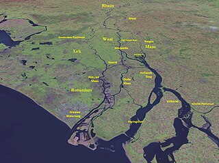
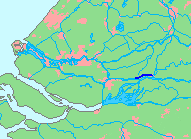
The Rhine–Meuse–Scheldt delta is a river delta in the Netherlands formed by the confluence of the Rhine, the Meuse and the Scheldt rivers. In some cases, the Scheldt delta is considered a separate delta to the Rhine–Meuse delta. The result is a multitude of islands, branches and branch names, in which a waterway that appears to be one continuous stream may have numerous separate names for different sections, e.g. Rhine → Bijlands Kanaal → Pannerdens Kanaal → Nederrijn → Lek → Nieuwe Maas → Het Scheur → Nieuwe Waterweg. Since the Rhine contributes most of the water, the term "Rhine Delta" is commonly used, although this name is also used for the delta where the Alpine Rhine flows into Lake Constance. By some calculations, the Rhine–Meuse–Scheldt delta covers 25,347 km2 (9,787 sq mi), making it the largest in Europe.

The siege of Schenkenschans was a major siege of the Eighty Years' War. In a successful campaign the Army of Flanders, commanded by Spanish general Cardinal-Infante Ferdinand of Austria, captured Schenkenschans along with a number of important towns, reversing recent Dutch gains and opening the Dutch Republic to a possible invasion. The Dutch Stadtholder, Fredrick Henry, pushed the republic's military efforts to their limit to recapture the fortress of Schenkenschans to counter the threat to the exposed Dutch heartland. He succeeded in doing so after a costly nine month siege.
The Steenenhoek Canal is a Dutch canal in southeastern Netherlands.

Schenkenschanz is a small community in North Rhine-Westphalia, Germany that was incorporated into the town of Kleve (Cleves) in 1969. Schenkenschanz is site of the former Schenkenschans fortress that was of significance in the Dutch Revolt.
